
Kamendin railway station
Kamendin Камендин / Kamendin | |||||||||||||||||||||||||||||||||||||||||||||||||||||||||||||||||||||||||||||
|---|---|---|---|---|---|---|---|---|---|---|---|---|---|---|---|---|---|---|---|---|---|---|---|---|---|---|---|---|---|---|---|---|---|---|---|---|---|---|---|---|---|---|---|---|---|---|---|---|---|---|---|---|---|---|---|---|---|---|---|---|---|---|---|---|---|---|---|---|---|---|---|---|---|---|---|---|---|
| rapid transit | |||||||||||||||||||||||||||||||||||||||||||||||||||||||||||||||||||||||||||||
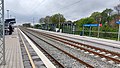
 View from platform I, looking toward Zemun Polje | |||||||||||||||||||||||||||||||||||||||||||||||||||||||||||||||||||||||||||||
| General information | |||||||||||||||||||||||||||||||||||||||||||||||||||||||||||||||||||||||||||||
| Location | Zemun Serbia | ||||||||||||||||||||||||||||||||||||||||||||||||||||||||||||||||||||||||||||
| Coordinates | 44°52′02″N 20°19′14″E / 44.86722°N 20.32056°E | ||||||||||||||||||||||||||||||||||||||||||||||||||||||||||||||||||||||||||||
| Platforms | 2 side platforms | ||||||||||||||||||||||||||||||||||||||||||||||||||||||||||||||||||||||||||||
| Connections | bus 704, 707, 709 | ||||||||||||||||||||||||||||||||||||||||||||||||||||||||||||||||||||||||||||
| Construction | |||||||||||||||||||||||||||||||||||||||||||||||||||||||||||||||||||||||||||||
| Structure type | at-grade | ||||||||||||||||||||||||||||||||||||||||||||||||||||||||||||||||||||||||||||
| Parking | no | ||||||||||||||||||||||||||||||||||||||||||||||||||||||||||||||||||||||||||||
| Bicycle facilities | outdoor railings | ||||||||||||||||||||||||||||||||||||||||||||||||||||||||||||||||||||||||||||
| Accessible | yes; elevators | ||||||||||||||||||||||||||||||||||||||||||||||||||||||||||||||||||||||||||||
| History | |||||||||||||||||||||||||||||||||||||||||||||||||||||||||||||||||||||||||||||
| Opened | 2022 | ||||||||||||||||||||||||||||||||||||||||||||||||||||||||||||||||||||||||||||
| Electrified | yes | ||||||||||||||||||||||||||||||||||||||||||||||||||||||||||||||||||||||||||||
| |||||||||||||||||||||||||||||||||||||||||||||||||||||||||||||||||||||||||||||
| |||||||||||||||||||||||||||||||||||||||||||||||||||||||||||||||||||||||||||||

The Kamendin railway station is a railway stop that serves the Zemun Polje and Kamendin neighborhoods of Zemun, Serbia. It is located on railway line 101/105, between Zemun Polje and Batajnica railway stations, at the location of a former level crossing.
Along with the nearby Altina train stop, the Kamendin stop was constructed as part of the Belgrade–Novi Sad railway reconstruction of 2019–2022.[1] It is served by BG Voz urban rail trains.
Layout
[edit]The stop has two side platforms, each 110 meters long,[2] serving two tracks. The platforms are connected by an underground passageway.
Services and access
[edit]The stop is equipped with elevators, and features an automated public address system. Bicycle parking is marked by the hand railings.
Nearby are bus stops served by city bus lines 704, 707 and 709.
Gallery
[edit]-
 View from platform II, looking toward Batajnica station
 -
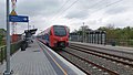 Regio service to Novi Sad passing through on track 1


See also
[edit]References
[edit]- ^ "Три нова стајалишта на брзој прузи: Тошин бунар, Алтина и Камендин" [Three new stops on the rapid railway: Tošin Bunar, Altina, and Kamendin]. Infrastruktura železnice Srbije (in Serbian). 3 March 2022. Retrieved 26 April 2022.
- ^ "Нова стајалишта на брзој прузи – Алтина и Камендин" [New stops on rapid railway – Altina and Kamendin]. Opština Zemun (in Serbian). 4 March 2022. Retrieved 26 April 2022.