
Krásna
Krásna | |
|---|---|
Borough | |
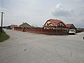
 Park in front of the church in Krásna | |
 Flag  Coat of arms | |
 Location within Košice | |
| Country | Slovakia |
| Region | Košice |
| District | Košice IV |
| Village | 1143 (first known record) |
| Borough | 1945 |
| Area | |
| • Total | 20.05 km2 (7.74 sq mi) |
| Elevation | 192 m (630 ft) |
| Population (31 December 2017) | |
| • Total | 5,401 |
| • Density | 270/km2 (700/sq mi) |
| Postal code | 040 18 |
| Area code | +421-55 |
| Car plate | KE |
| Website | www.kosicekrasna.sk |
| Source [1] | |
Krásna (literally: "beautiful" in English, Hungarian: Abaszéplak) is a borough (city ward) of the city of Košice, Slovakia. Located in the Košice IV district, it lies at an altitude of roughly 192 metres (630 ft) above sea level, and is home to over 5,000 people. Despite new small-scale housing developments, it retains much of its rural character.
History[edit]
The first written record of Krásna dates back to 1143. It was an independent village municipality until 1945, when it was connected with Košice.
In the past, it was also known under the municipal name Krásna nad Hornádom ("Krásna-upon-Hornád").
Evolution of the borough's name[edit]
Some of the recorded historical names of Krásna.
- 1219 - abbas de Zebloc (Latin)
- 1255 - Sceplok
- 1280 - monast. Zceplak
- 1288 - villa Zeplak
- 1327 - poss. Zyplok
- 1328 - Zeplak
- 1335 - poss. Sceplok, Sceplak
- 1337 - Zeplak
- 1808 - Szýplak (Hungarian)
- 1906 - Siplak
- 1918 - Krásna nad Hornádom (Slovak)
Statistics[edit]
- Area: 20.05 square kilometres (7.74 sq mi)
- Population: 5,401 (31 December 2017)
- Density of population: 270/km2 (31 December 2017)
- District: Košice IV
- Mayor: Peter Tomko (as of 2018 elections)
Gallery[edit]
-
 Meško manor house post-reconstruction, at night time (August 2015)
 -
 Meško manor house in Krásna borough, before reconstruction (May 2012)
 -
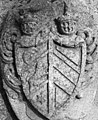 Coat of arms of József Mesko de Széplak, former owner of the manor house, tomb at Krásna cemetery
 -
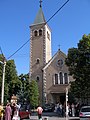 Church of St Cyril and St Methodius in the Krásna borough
 -
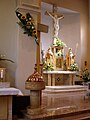 Interior and altar of the St Cyril and St Methodius church
 -
 Tourist cycling trail in the countryside around Krásna
 -
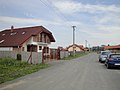 New housing development in Krásna
 -
 New housing development in Krásna
.jpg)


.jpg)
.jpg)
.jpg)
References[edit]
- ^ Mestská a obecná štatistika SR (urgently needs an updated statistics link for 2018) Archived 2007-04-27 at the Wayback Machine
External links[edit]
Wikimedia Commons has media related to Krásna.
- Official website of the Krásna borough
- Article on the Krásna borough at Cassovia.sk
- History of the manor house in Krásna
- Official website of Košice
48°40′21″N 21°19′08″E / 48.67250°N 21.31889°E
| International | |
|---|---|
| National | |