Kurtzenhouse
Appearance
You can help expand this article with text translated from the corresponding article in French. (December 2008) Click [show] for important translation instructions.
|
Kurtzenhouse
Kurzehüse | |
|---|---|
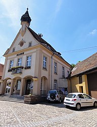
 The town hall in Kurtzenhouse | |
| Coordinates: 48°44′27″N 7°48′28″E / 48.7408°N 7.8078°E | |
| Country | France |
| Region | Grand Est |
| Department | Bas-Rhin |
| Arrondissement | Haguenau-Wissembourg |
| Canton | Brumath |
| Government | |
| • Mayor (2020–2026) | Marc Moser[1] |
Area 1 | 3.58 km2 (1.38 sq mi) |
| Population (2022)[2] | 1,087 |
| • Density | 300/km2 (790/sq mi) |
| Time zone | UTC+01:00 (CET) |
| • Summer (DST) | UTC+02:00 (CEST) |
| INSEE/Postal code | 67252 /67240 |
| Elevation | 126–179 m (413–587 ft) |
| 1 French Land Register data, which excludes lakes, ponds, glaciers > 1 km2 (0.386 sq mi or 247 acres) and river estuaries. | |
Kurtzenhouse (German: Kurzenhausen) is a commune in the Bas-Rhin department in Grand Est in north-eastern France.[3]
The name of the commune was officially changed from Kurtzenhausen to Kurtzenhouse in January 1955.[4]
Geography
[edit]The village is positioned about ten kilometres (six miles) south of Haguenau: the surrounding countryside is largely taken up with agriculture. Through the south-eastern side of the commune runs the departmental road RD 37, and beside that the rather indirect railway line that connects Haguenau with Strasbourg to the south.
See also
[edit]References
[edit]- ^ "Répertoire national des élus: les maires" (in French). data.gouv.fr, Plateforme ouverte des données publiques françaises. 13 September 2022.
- ^ "Populations de référence 2022" (in French). The National Institute of Statistics and Economic Studies. 19 December 2024.
- ^ INSEE commune file
- ^ Décret du 5 janvier 1955 portant changement de nom de la commune de Kurtzenhausen (Bas-Rhin), Journal officiel de la République française n° 0009, 9 January 1955, p. 409.
Wikimedia Commons has media related to Kurtzenhouse.


