Lake Man
| Lake Man 漫湖 Manko | |
|---|---|
 Lake Man | |
| Location | Okinawa Prefecture, Japan |
| Coordinates | 26°11′49.8″N 127°41′00.0″E / 26.197167°N 127.683333°E |
| Basin countries | Japan |
| Surface area | .11 square kilometres (0.042 sq mi) |
| Settlements | Naha and Tomigusuku, Okinawa, Okinawa Prefecture |
| Official name | Manko |
| Designated | 15 May 1999 |
| Reference no. | 996[1] |
Lake Man (漫湖, Manko) is an area of wetlands in Okinawa that is located between the cities of Naha and Tomigusuku, and within Manko Park.[2] Despite being called "Lake Man", it is in fact a wetland and not a lake. Lake Man covers .11 square kilometres (0.042 sq mi).[2]
Lake Man is close to Naha Port, located at the confluence of the lower reaches of the Kokuba River and the Noha River, to the south of Naha. Travelers from outside Okinawa Prefecture, en route from Naha Airport to the city Naha, cross this estuary, with the left side commanding a view of Lake Man.
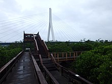
The Manko Waterbird and Wetland Center is located next to the wetland area and provides information and activities related to the area, as well as a boardwalk into the wetlands.[3]
The name Manko is pronounced the same as a crude Japanese word for female genitals, resulting in some controversy.[4]
Nature
[edit]Lake Man is an area of brackish water at almost the same elevation as sea level. Since the 1960s, with the planting of mangroves, it has been transforming into tidelands. It has also become a relay point for migrating birds such as shorebirds and plovers, and in 1999 was designated a wetland of international importance under the Ramsar Convention.[5]
A number of threatened species inhabit Lake Man, such as the shellfish Macoma nobilis, which is found only on Okinawa Island. The lake is also a noted home to sandpipers and plovers.[2]

Deposition of sediments and the worsening of water quality due to the influx of wastewater are among the problems facing these wetlands.
References
[edit]- ^ "Manko". Ramsar Sites Information Service. Retrieved 25 April 2018.
- ^ a b c "漫湖" [Lake Man]. Dijitaru Daijisen (in Japanese). Tokyo: Shogakukan. 2013. OCLC 56431036. Archived from the original on 2007-08-25. Retrieved 2013-09-24.
- ^ "English Guide|Manko Waterbird & Wetland Center 英語版 案内 | 漫湖水鳥・湿地センター". www.manko-mizudori.net. Retrieved 2019-07-25.
- ^ Jisho search on Manko
- ^ "Ramsar Sites in Japan - Manko" (PDF). Ministry of the Environment. Retrieved 24 March 2011.
External links
[edit]- wildlife of Lake Man in English
- Manko Waterbird and Wetland Center in English

