Lake Rotopokaka
| Lake Rotopokaka | |
|---|---|
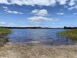
 Lake Rotopokaka in 2020 | |
| Location | Far North District, Northland Region, North Island |
| Coordinates | 34°57′00″S 173°22′59″E / 34.950°S 173.383°E |
| Type | Dune lake |
| Basin countries | New Zealand |
| Surface area | 11 hectares (27 acres) |
| Max. depth | 3.5 m (11 ft) |
Lake Rotopokaka is a dune lake in the Far North District of New Zealand. It is adjacent to Tokerau Beach on the east coast of the Karikari Peninsula. The lake is also known as 'Coca Cola lake' as the peat and tannins in the water give the lake a distinct 'cola' colour.[1]
The lake has no inflows or outflows. The surrounding catchment is a mixture of manuka scrub, pohutukawa, cabbage tree and flax.[2]
The lake is a popular recreation area and can be accessed off Ramp Road.
References[edit]
- ^ "Wetlands you can visit in the Northland Region" (PDF). www.wetlandtrust.org.nz. Retrieved 27 April 2020.
- ^ "Northland Lakes Ecological Status 2010". Northland Regional Council. Retrieved 27 April 2020.

