Les Mines
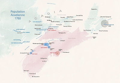
Les Mines was the name generally applied the Acadian settlements in the western Minas Basin in Nova Scotia. They included the villages of Grand-Pré, New Minas, Rivière-aux-Canards but usually excluded the villages at Pisiguit, Cobequid, and Beaubassin.[1] The name originated with early French explorers who identified copper mines at Cape d'Or as "Les Mines" and the name was gradually transferred to identify the Basin beyond Cape d'Or and its settlements. Founded in the 1680s, the communities which comprised Les Mines grew and prospered based on skilled development of dyked marsh lands for agriculture. However the settlements were destroyed in the 1755 Bay of Fundy Campaign of the Deportation of the Acadians.[2]
Evolution of the population
[edit]
| Year | Inhabitants |
|---|---|
| 1689 | 57 |
| 1689 | 165 |
| 1689 | 305 |
| 1701 | 487 |
| 1703 | 527 |
| 1707 | 677 |
| 1714 | 1,031 |
| 1730 | 2,500 |
| 1737 | 2,736 |
| 1750 | 2,450 |
| 1752 | 928 |
From the table, one can notice that by 1752, already more than half the population of Les Mines had migrated to Isle Saint-Jean (P.E.I.) and Isle Royale (Cap Breton).
References
[edit]- ^ "Les Mines", Acadian Genealogy and History
- ^ ARSENAULT, Bona, Histoire des Acadiens, Le Conseil de la vie française en Amérique, Québec, 1966.
- ^ Recensements d'Acadie (1671–1752), Archives des Colonies, Série G1, vol. 466–1, p 228.

