
Lignol, Morbihan
Lignol
An Ignol | |
|---|---|
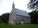
 The parish church | |
Location of Lignol  | |
 Lignol  Lignol | |
| Coordinates: 48°02′18″N 3°16′10″W / 48.0383°N 3.2694°W | |
| Country | France |
| Region | Brittany |
| Department | Morbihan |
| Arrondissement | Pontivy |
| Canton | Gourin |
| Intercommunality | Roi Morvan Communauté |
| Government | |
| • Mayor (2020–2026) | Carole Le Yaouanq[1] |
| Area 1 | 38.43 km2 (14.84 sq mi) |
| Population (2021)[2] | 849 |
| • Density | 22/km2 (57/sq mi) |
| Demonym(s) | Lignolais, Lignolaises |
| Time zone | UTC+01:00 (CET) |
| • Summer (DST) | UTC+02:00 (CEST) |
| INSEE/Postal code | 56110 /56160 |
| Elevation | 93–187 m (305–614 ft) |
| 1 French Land Register data, which excludes lakes, ponds, glaciers > 1 km2 (0.386 sq mi or 247 acres) and river estuaries. | |
Lignol (French pronunciation: [liɲɔl]; Breton: An Ignol) is a commune in the Morbihan department of Brittany in north-western France.[3]
Population[edit]
Lignol's population peaked in 1911. Lignol's population has been decreased by half since this date because of rural exodus. Inhabitants of Lignol are called in French Lignolais.
|
| |||||||||||||||||||||||||||||||||||||||||||||||||||||||||||||||||||||||||||||||||||||||||||||||||||||||||||||||
| ||||||||||||||||||||||||||||||||||||||||||||||||||||||||||||||||||||||||||||||||||||||||||||||||||||||||||||||||
| Source: EHESS[4] and INSEE (1968-2020)[5] | ||||||||||||||||||||||||||||||||||||||||||||||||||||||||||||||||||||||||||||||||||||||||||||||||||||||||||||||||
Geography[edit]
Lignol lies in the valley of the river Scorff. The village centre is located 16 km (9.9 mi) east of Le Faouët, 22 km (14 mi) west of Pontivy and 33 km (21 mi) north of Lorient. Historically, it belongs to Vannetais.
Map[edit]

History[edit]
There is a church in this town that was built during the 14th century. Lignol also has two castles, they were the homes of the dukes that used to rule the place and were under the domination of the House of Rohan. Lignol was the main place of the French resistance against the German occupation in the Guémené-sur-Scorff area. Since the Nazis occupied Guémené-sur-Scorff, the Resistance used the nearby towns as bases. Langoëlan and Lignol were their main ones in the region.
Economy[edit]
Agriculture is the main source of resources of the town.
Politics[edit]
During the presidential 2007 elections, inhabitants voted for Nicolas Sarkozy. Its current mayor is a former farmworker.
Sport[edit]
Lignol has a soccer club in association with the neighbouring town of Kernaskleden.
Gallery[edit]
-
 Coscro castle
 -
 Manor of Kerouallan
 -
 The ancient presbitery
 -
 Chapel of Saint Melan
 -
 Chapel of Saint Yves
 -
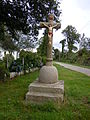 Christianized Iron Age stele


See also[edit]
References[edit]
- ^ "Maires du Morbihan" (PDF). Préfecture du Morbihan. 7 July 2020.
- ^ "Populations légales 2021". The National Institute of Statistics and Economic Studies. 28 December 2023.
- ^ INSEE commune file
- ^ Des villages de Cassini aux communes d'aujourd'hui: Commune data sheet Lignol, EHESS (in French).
- ^ Population en historique depuis 1968, INSEE
External links[edit]
- Base Mérimée: Search for heritage in the commune, Ministère français de la Culture. (in French)
- Mayors of Morbihan Association (in French)
| Authority control databases: National |
|---|