Mačkat
Mačkat
Мачкат | |
|---|---|
Village | |
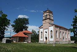
 Church in Mačkat | |
| Coordinates: 43°47′00″N 19°46′00″E / 43.7833°N 19.7667°E | |
| Country | |
| District | Zlatibor District |
| Municipality | Čajetina |
| Area | |
| • Total | 10.76 km2 (4.15 sq mi) |
| Elevation | 750 m (2,460 ft) |
| Population (2011) | |
| • Total | 905 |
| • Density | 84/km2 (220/sq mi) |
| Time zone | UTC+1 (CET) |
| • Summer (DST) | UTC+2 (CEST) |
Mačkat (Serbian Cyrillic: Мачкат) is a village in Serbia situated in the municipality of Čajetina, and the district of Zlatibor. As of 2011, it has a population of 905 inhabitants.
References[edit]
- ^ "Насеља општине Чајетина" (PDF). stat.gov.rs (in Serbian). Statistical Office of Serbia. Retrieved 12 October 2019.
External links[edit]
- (in English) Satellite view of Mačkat
- (in English) Mačkat

