
Millswood, South Australia
| Millswood Adelaide, South Australia | |||||||||||||||
|---|---|---|---|---|---|---|---|---|---|---|---|---|---|---|---|
 Millswood Crescent, looking towards the south-west | |||||||||||||||
| Population | 2,173 (SAL 2021)[1] | ||||||||||||||
| Postcode(s) | 5034 | ||||||||||||||
| Elevation | 44 m (144 ft) | ||||||||||||||
| Location | 5 km (3 mi) S of Adelaide | ||||||||||||||
| LGA(s) | City of Unley | ||||||||||||||
| State electorate(s) | |||||||||||||||
| Federal division(s) | |||||||||||||||
| |||||||||||||||
Millswood is an inner-southern mainly residential suburb of Adelaide in the City of Unley. It was named after Scotsman Samuel Mills, who arrived in the colony in 1839.
Description
[edit]The suburb is dissected by Goodwood Road, which travels north to the Adelaide city centre from the southern suburb of Pasadena. On the west side of Goodwood Road it is surrounded by the suburbs of Goodwood, Forestville, Black Forest and Clarence Park. On the east side of Goodwood Road it is surrounded by the suburbs of Goodwood, Hyde Park, Unley Park and Kings Park.
At the northern edge of the west side of the suburb, the Adelaide-Goodwood railway line forks with the Seaford railway line going south-west and the Belair railway line going south-east. Millswood railway station, located on the Belair line, on the southern edge of the suburb, was closed in 1995 but reopened in 2014.[2]
Goodwood Road passes under the railway line in a deep underpass, known as the Goodwood Subway, which often floods during heavy rain.
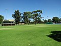
Within the triangle formed by the railway fork and Millswood Crescent are the SASMEE ( South Australian Society of Model & Experimental Engineers) Park[3] and the Millswood croquet, lawn bowls and lawn tennis clubs. The Goodwood Oval and grandstand, with playground, barbeque facilities, soccer pitch and grandstand, cricket practice nets, and eight hard tennis courts, are located to the west of the fork in the railway line.
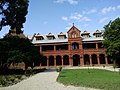
The former Goodwood Orphanage and the surrounding Orphanage Park are located on the south-east corner of Goodwood Road and Mitchell Street and now houses Tabor College Australia.[4]
History
[edit]Millswood was named after Scotsman Samuel Mills, who arrived in the colony in 1839 and owned a property called Ravenswood Farm.[5]
In 1917, Hackett's Nursery, a family-run business then in Marryatville, was sold to a limited company, E. & W. Hackett Limited, with the Hacketts continuing as directors. In the same year the business bought a 6-acre (2.4 ha) plot[6] in the Millswood Estate for over £20,067[7] to accommodate the nursery,[8] which drew glowing praise in a 1923 newspaper article[6] and continued to do business there until 1952.[5]
Gallery
[edit]-
 The former Goodwood Orphanage
 -
 Goodwood Oval Grandstand
 -
 Goodwood Oval
 -
 Goodwood Subway – from the railway bridge
 -
 Goodwood Subway – from Goodwood Road
 -
 (Closed) Millswood Railway station in 2008
 -
 Millswood Railway station in 2018

.jpg)


References
[edit]- ^ Australian Bureau of Statistics (28 June 2022). "Millswood (suburb and locality)". Australian Census 2021 QuickStats. Retrieved 28 June 2022.
- ^ http://www.adelaidenow.com.au/messenger/east-hills/millswood-train-station-is-set-to-remain-open-permanently-after-a-successful-year-long-trial/story-fni9lkyu-1227571788017?sv=e2ad48e8c777ce77b47c4e544171bb17&nk=73c2ac11b20cf2a1fcda6c99c42553b4-1466231686 [bare URL]
- ^ SASMEE – The South Australian Society of Model & Experimental Engineers, www.sasmee.com.au
- ^ History, www.goodwoodroad.com.au
- ^ a b McDougall & Vines (2006). "Unley Heritage Research Study for the City of Unley: Volume I" (PDF). Retrieved 26 July 2019.
- ^ a b "Hackett's Nursery". The Journal (Adelaide). Vol. LVI, no. 15420. South Australia. 7 May 1921. p. 15 (Night Edition). Retrieved 25 July 2019 – via National Library of Australia.
- ^ "The Millswood Estate". The Mail (Adelaide). Vol. 6, no. 279. South Australia. 22 September 1917. p. 4. Retrieved 26 July 2019 – via National Library of Australia.
- ^ "An Old-Time Garden". The Observer (Adelaide). Vol. LXXX, no. 5, 960. South Australia. 21 April 1923. p. 41. Retrieved 25 July 2019 – via National Library of Australia.