Mioko Island
Appearance
Native name: Kilungaul | |
|---|---|
 Duke of York Islands | |
| Geography | |
| Location | Oceania |
| Coordinates | 4°13′47″S 152°27′36″E / 4.22972°S 152.46000°E |
| Archipelago | bismark |
| Area | 1.3 km2 (0.50 sq mi) |
| Highest point | 33 |
| Administration | |
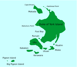
Mioko is a populated island in the Duke of York Islands archipelago in Papua New Guinea.[1] Located in East New Britain Province, in the east of the country, about 800 km (500 mi) north of Port Moresby.
Geography
[edit]
The land of Mioko Island is generally flat with the highest point being 33 metres (108 ft) above sea level. The island is about 1.3 km (0.81 mi) from north to south and 1.9 km (1.2 mi) east to west with an area of about 1.3 square kilometres (0.50 sq mi).
References
[edit]- ^ Mioko Island: Papua New Guinea National Geospatial-Intelligence Agency, Bethesda, MD, USA

