
Mount Belknap (Utah)
| Mount Belknap | |
|---|---|
 South aspect | |
| Highest point | |
| Elevation | 12,143 ft (3,701 m)[1] |
| Prominence | 1,192 ft (363 m)[1] |
| Parent peak | Delano Peak[1] |
| Isolation | 4.12 mi (6.63 km)[1] |
| Coordinates | 38°25′09″N 112°24′45″W / 38.4192011°N 112.4125695°W[2] |
| Naming | |
| Etymology | William W. Belknap |
| Geography | |
 Mount Belknap Location in Utah  Mount Belknap Mount Belknap (the United States) | |
| Country | United States |
| State | Utah |
| County | Beaver / Piute |
| Protected area | Fishlake National Forest |
| Parent range | Tushar Mountains[3] |
| Topo map | USGS Mount Belknap |
| Geology | |
| Age of rock | Miocene |
| Mountain type | Volcanic field |
| Type of rock | Rhyolite (volcanic rock)[4] |
| Volcanic arc/belt | Marysvale volcanic field |
| Climbing | |
| Easiest route | class 1+ hiking[1] |
Mount Belknap is a 12,143-foot-elevation (3,701-meter) mountain summit in the Tushar Mountains of Utah, United States.
Description[edit]
Mount Belknap is set in the Fishlake National Forest on the boundary that Beaver County shares with Piute County.[2] It ranks as the second-highest peak in the Tushar Mountains,[3] second-highest in each county and 73rd-highest in the state.[1] Precipitation runoff from the mountain drains into the Sevier River watershed via Blue Lake Creek, Fish Creek, and Beaver Creek.[3] Topographic relief is significant as the summit rises over 2,700 feet (823 meters) above Fish Creek in one mile (1.6 km). Mount Belknap is named after William Worth Belknap (1829–1890), the United States Secretary of War who served under President Ulysses S. Grant.[5] This mountain's toponym has been officially adopted by the United States Board on Geographic Names.[2]
Climate[edit]
Based on the Köppen climate classification, Mount Belknap is located in a dry summer subarctic climate zone (Köppen Dsc) with cold snowy winters and mild summers.[6]
Gallery[edit]
-
 South aspect
 -
 South aspect
 -
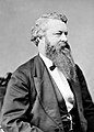 William W. Belknap


See also[edit]
References[edit]
- ^ a b c d e f "Belknap, Mount - 12,143' UT". listsofjohn.com. Retrieved 2024-06-11.
- ^ a b c "Mount Belknap". Geographic Names Information System. United States Geological Survey, United States Department of the Interior. Retrieved 2024-06-11.
- ^ a b c "Mount Belknap, Utah". Peakbagger.com. Retrieved 2024-06-11.
- ^ Charles G. Cunningham, Mount Belknap and Red Hills Calderas and Associated Rocks, Marysvale Volcanic Field, West-central Utah, US Geological Survey, U.S. Government Printing Office, 1979, p. 18.
- ^ Henry Gannett, The Origin of Certain Place Names in the United States, U.S. Government Printing Office, 1902, p. 39.
- ^ Peel, M. C.; Finlayson, B. L. & McMahon, T. A. (2007). "Updated world map of the Köppen−Geiger climate classification". Hydrol. Earth Syst. Sci. 11 (5): 1633–1644. Bibcode:2007HESS...11.1633P. doi:10.5194/hess-11-1633-2007. ISSN 1027-5606. S2CID 9654551.
External links[edit]
- Mount Belknap: weather forecast
- National Geodetic Survey Data Sheet
Places adjacent to Mount Belknap (Utah) | ||||||||||||||||
|---|---|---|---|---|---|---|---|---|---|---|---|---|---|---|---|---|
| ||||||||||||||||