
Mount Rixford
| Mount Rixford | |
|---|---|
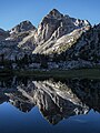
 North aspect reflected in Rae Lakes | |
| Highest point | |
| Elevation | 12,887 ft (3,928 m)[1] |
| Prominence | 584 ft (178 m)[1] |
| Parent peak | Mount Gould (13,011 ft)[2] |
| Isolation | 1.20 mi (1.93 km),[2] |
| Listing | Sierra Peaks Section |
| Coordinates | 36°47′05″N 118°23′56″W / 36.7848556°N 118.3988868°W[3] |
| Naming | |
| Etymology | Dr. Emmet Rixford |
| Geography | |
 Mount Rixford Location in California  Mount Rixford Mount Rixford (the United States) | |
| Location | Kings Canyon National Park Fresno County California, U.S. |
| Parent range | Sierra Nevada |
| Topo map | USGS Mount Clarence King |
| Geology | |
| Mountain type | Fault block |
| Type of rock | Metamorphic rock[4] |
| Climbing | |
| First ascent | 1897 |
| Easiest route | class 2[2] South slope |
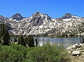
Mount Rixford is a 12,887-foot-elevation (3,928-meter) mountain summit located one mile west of the crest of the Sierra Nevada mountain range, in the southeast corner of Fresno County, in northern California.[3] It is situated in Kings Canyon National Park, 11.5 miles (18.5 km) west of the community of Independence, and one mile north of the Kearsarge Pinnacles and Kearsarge Lakes. Topographic relief is significant as the north aspect rises 2,346 feet (715 meters) above Rae Lakes in one mile. The John Muir Trail crosses Glen Pass one mile to the west of this mountain. Mt. Rixford ranks as the 183rd highest summit in California.[2] Painted Lady is a subsidiary summit at the end of Rixford's north ridge.
History[edit]
This geographical feature was named for world-famous San Francisco surgeon Dr. Emmet Rixford (1865–1938), who made the first ascent of the summit in 1897 with two companions.[5][6] As a Sierra Club explorer, he enjoyed mountaineering with companions such as the naturalist John Muir.[7] Dr. Rixford was the president of the American Surgical Association in 1927. The mountain was named in 1899 by an ascent party from Stanford University who found Rixford's name in the summit cairn. That subsequent party was David Starr Jordan, Vernon Lyman Kellogg, Ellwood Patterson Cubberley and Mrs. Cubberley.[8] Theirs was the third ascent of the peak, the second ascent was made by Bolton Brown in the intervening year.
Climate[edit]
According to the Köppen climate classification system, Mount Rixford is located in an alpine climate zone.[9] Most weather fronts originate in the Pacific Ocean, and travel east toward the Sierra Nevada mountains. As fronts approach, they are forced upward by the peaks, causing them to drop their moisture in the form of rain or snowfall onto the range (orographic lift). Precipitation runoff from this peak drains into tributaries of the South Fork Kings River.
Gallery[edit]
-
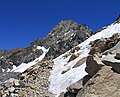 Mount Rixford from John Muir Trail below Glen Pass
 -
 South aspect of Mt. Rixford (centered), from Vidette Lakes.
(Falcor Peak to right) -
 Mt. Rixford behind Painted Lady
 -
 Mt. Rixford behind Painted Lady, from Rae Lakes
 -
 Painted Lady centered with Mt. Rixford behind left
 -
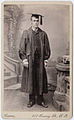 Dr. Emmet Rixord, 1887
 -
 Painted Lady with partly visible Mt. Rixford behind right
 -
 Mt. Rixford to right of center


.jpg)


.jpg)
See also[edit]
References[edit]
- ^ a b "Mount Rixford, California". Peakbagger.com. Retrieved 2021-04-26.
- ^ a b c d "Rixford, Mount - 12,887' CA". listsofjohn.com. Retrieved 2021-04-26.
- ^ a b "Mount Rixford". Geographic Names Information System. United States Geological Survey, United States Department of the Interior. Retrieved 2021-04-26.
- ^ Joseph E. Brown (1984), The Sierra Club Guides to the National Parks of the Pacific Southwest and Hawaii, Random House, ISBN 9780394724904, p. 114.
- ^ R. J. Secor, The High Sierra Peaks, Passes, Trails, 2009, Mountaineers Books, ISBN 9780898869712, page 170.
- ^ Francis P. Farquhar, Place Names of the High Sierra (1926)
- ^ Sausalito News, 7 January 1938
- ^ Vernon L. Kellogg, A Stanford Party in the Kings River Canyon, Sunset Magazine, November 1899, page 18.
- ^ Peel, M. C.; Finlayson, B. L.; McMahon, T. A. (2007). "Updated world map of the Köppen−Geiger climate classification". Hydrol. Earth Syst. Sci. 11. ISSN 1027-5606.
External links[edit]
- Weather forecast: Mount Rixford
- Emmet Rixford photo
Places adjacent to Mount Rixford | |
|---|---|