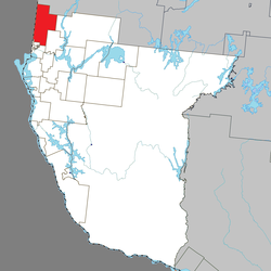
Nédélec
Nédélec | |
|---|---|
 | |
 Location within Témiscamingue RCM | |
| Coordinates: 47°41′N 79°26′W / 47.683°N 79.433°W[1] | |
| Country | Canada |
| Province | Quebec |
| Region | Abitibi-Témiscamingue |
| RCM | Témiscamingue |
| Settled | 1895 |
| Constituted | February 1, 1909 |
| Named for | Jean-Marie Nédélec[1] |
| Government | |
| • Mayor | Lyne Ash |
| • Federal riding | Abitibi—Témiscamingue |
| • Prov. riding | Rouyn-Noranda–Témiscamingue |
| Area | |
• Total | 375.14 km2 (144.84 sq mi) |
| • Land | 371.49 km2 (143.43 sq mi) |
| Population (2021)[3] | |
• Total | 340 |
| • Density | 0.9/km2 (2/sq mi) |
| • Pop (2016-21) | |
| • Dwellings | 168 |
| Time zone | UTC−05:00 (EST) |
| • Summer (DST) | UTC−04:00 (EDT) |
| Postal code(s) | |
| Area code | 819 |
| Highways | |
| Website | municipalite |
Nédélec (French pronunciation: [nedelɛk]) is a township municipality in western Quebec, Canada, in the Témiscamingue Regional County Municipality.
The name of the municipality recalls the name of Jean-Marie Nédélec who was an oblate and a missionary with the Algonquins in the region. His last name is from the Breton word Nedeleg which means Christmas.
History
[edit]By 1895, a general store was supplying the many logging camps of the area. The first permanent settlers arrived in 1909, the same year the township and township municipality were formed. They were both named after Jean-Marie Nédélec (1834-1896) who was a missionary among the Algonquin First Nations of Lake Timiskaming and Lake Abitibi from 1867 to 1869 and from 1892 to 1896.[1]
On October 7, 1995, the unorganized territory of Roulier, named after Ulric Roulier who was priest at Nédélec in the mid-1930s, was added to the municipality.[1]
Demographics
[edit]In the 2021 Census of Population conducted by Statistics Canada, Nédélec had a population of 340 living in 152 of its 168 total private dwellings, a change of -4.5% from its 2016 population of 356. With a land area of 371.49 km2 (143.43 sq mi), it had a population density of 0.9/km2 (2.4/sq mi) in 2021.[3]
| 2021 | 2016 | 2011 | |
|---|---|---|---|
| Population | 340 (-4.5% from 2016) | 356 (-11.7% from 2011) | 403 (-3.1% from 2006) |
| Land area | 371.49 km2 (143.43 sq mi) | 374.10 km2 (144.44 sq mi) | 374.06 km2 (144.43 sq mi) |
| Population density | 0.9/km2 (2.3/sq mi) | 1.0/km2 (2.6/sq mi) | 1.1/km2 (2.8/sq mi) |
| Median age | 50.0 (M: 53.2, F: 47.2) | 48.9 (M: 51.1, F: 45.2) | 43.5 (M: 45.0, F: 40.9) |
| Private dwellings | 168 (total) 152 (occupied) | 181 (total) 159 (occupied) | 175 (total) 165 (occupied) |
| Median household income | $63,200 | $50,240 | $35,890 |
|
|
| ||||||||||||||||||||||||||||||||||||||||||||||||||||||||||||||||||
| Population counts are not adjusted for boundary changes. Source: Statistics Canada[3][9] | ||||||||||||||||||||||||||||||||||||||||||||||||||||||||||||||||||||
Mother tongue (2021):[3]
- English as first language: 10.3%
- French as first language: 88.2%
- English and French as first language: 0%
- Other as first language: 1.5%
See also
[edit]References
[edit]- ^ a b c d "Nédélec (Municipalité de canton)" (in French). Commission de toponymie du Québec. Retrieved 2011-01-04.
- ^ a b "Répertoire des municipalités: Geographic code 85100". www.mamh.gouv.qc.ca (in French). Ministère des Affaires municipales et de l'Habitation. Retrieved 2023-12-12.
- ^ a b c d e "Nédélec (Code 2485100) Census Profile". 2021 census. Government of Canada - Statistics Canada. Retrieved 2023-12-12.
- ^ "2021 Community Profiles". 2021 Canadian census. Statistics Canada. February 4, 2022. Retrieved 2023-12-12.
- ^ "2016 Community Profiles". 2016 Canadian census. Statistics Canada. August 12, 2021. Retrieved 2024-12-27.
- ^ "2011 Community Profiles". 2011 Canadian census. Statistics Canada. March 21, 2019. Retrieved 2024-12-27.
- ^ "2006 Community Profiles". 2006 Canadian census. Statistics Canada. August 20, 2019.
- ^ "2001 Community Profiles". 2001 Canadian census. Statistics Canada. July 18, 2021.
- ^ 1996, 2001, 2006, 2011, 2016 census

