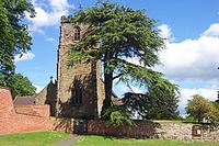
Netherseal
This article needs additional citations for verification. (December 2009) |
| Netherseal | |
|---|---|
 St. Peter's Church | |
Location within Derbyshire | |
| Population | 923 (2011) |
| OS grid reference | SK286131 |
| District | |
| Shire county | |
| Region | |
| Country | England |
| Sovereign state | United Kingdom |
| Post town | SWADLINCOTE |
| Postcode district | DE12 |
| Police | Derbyshire |
| Fire | Derbyshire |
| Ambulance | East Midlands |

Netherseal (or 'Netherseale') is a village and civil parish in the English county of Derbyshire,[1][2] situated in the South Derbyshire district. Together with neighbouring Lullington it is the southernmost village in the county. The population of the civil parish as of the 2011 census was 923.[3]
Location
[edit]The village is less than 2 miles from the neighbouring county of Leicestershire, and is close to the A444 and the M42 motorway, on the banks of the River Mease.[4]
History
[edit]St Peter's Church is the burial place of the railway engineer Sir Nigel Gresley, and the birthplace of the historian Eben William Robertson. It has a couple of 17th–century almshouses, but the home of the Gresley family was demolished in 1933.[4]
The village is home to football team Netherseal St. Peters.
See also
[edit]References
[edit]- ^ OS Explorer Map 245: The National Forest :(1:25 000) :ISBN 0 319 24028 2
- ^ Map Details retrieved 11 April 2013
- ^ "Civil Parish population 2011". Neighbourhood Statistics. Office for National Statistics. Retrieved 29 March 2016.
- ^ a b "Netherseal village in South Derbyshire".
External links
[edit]![]() Media related to Netherseal at Wikimedia Commons
Media related to Netherseal at Wikimedia Commons

