
Portal:New South Wales
The New South Wales Portal


New South Wales (commonly abbreviated as NSW) is a state on the east coast of Australia. It borders Queensland to the north, Victoria to the south, and South Australia to the west. Its coast borders the Coral and Tasman Seas to the east. The Australian Capital Territory and Jervis Bay Territory are enclaves within the state. New South Wales' state capital is Sydney, which is also Australia's most populous city. , the population of New South Wales was over 8.3 million, making it Australia's most populous state. Almost two-thirds of the state's population, 5.3 million, live in the Greater Sydney area.
The Colony of New South Wales was founded as a British penal colony in 1788. It originally comprised more than half of the Australian mainland with its western boundary set at 129th meridian east in 1825. The colony then also included the island territories of Van Diemen's Land, Lord Howe Island, and Norfolk Island. During the 19th century, most of the colony's area was detached to form separate British colonies that eventually became the various states and territories of Australia and, arguably, New Zealand. The Swan River Colony (later called the Colony of Western Australia) was never administered as part of New South Wales. (Full article...)
 Recognized content -
-

Snowy Mountains Highway is a 333-kilometre-long (207 mi) state highway located in New South Wales, Australia. Its two sections connect the New South Wales South Coast to the Monaro region, and the Monaro to the South West Slopes via the Snowy Mountains. The higher altitude regions of this road are subject to snow over the winter months, and the road also provides access to many parts of the Snowy Mountains Scheme. The highway bears the B72 shield along its entire length.
The highway originally bore the name Monaro Highway until 1958, when it received its current name. It originally ran from Tathra to Wagga Wagga but has been shortened to run from Princes Highway to Hume Highway instead. Part of the roadway was reallocated to what is now known as Monaro Highway in 1955. Reservoirs created as a result of dams built in the 1950s and 1960s as part of the Snowy Mountains Scheme required the creation of major realignments to avoid submerged areas. Previous to New South Wales' conversion to alphanumeric route markers, it was signed as National Route 18. (Full article...) -
Persoonia terminalis, also known as the Torrington geebung, is a shrub belonging to the family Proteaceae, and native to northern New South Wales and southern Queensland in eastern Australia. Reported as a subspecies of Persoonia nutans in 1981, it was described as a species by Lawrie Johnson and his colleague Peter Weston in 1991.
Two subspecies—P. t. terminalis and P. t. recurva—are recognised; both are found on well-drained acidic soils in sclerophyll forests, and P. t. terminalis is also found on granite outcrops. Although similar in appearance, they differ in leaf length and curvature. Both have a restricted range, with P. t. terminalis found in an area of under 100 square kilometres (39 square miles; 25,000 acres). (Full article...) -

Persoonia lanceolata, commonly known as lance-leaf geebung, is a shrub native to New South Wales in eastern Australia. It reaches 3 m (10 ft) in height and has smooth grey bark and bright green foliage. Its small yellow flowers grow on racemes and appear in the austral summer and autumn (January to April), followed by green fleshy fruits (known as drupes) which ripen the following spring (September to October). Within the genus Persoonia, P. lanceolata belongs to the lanceolata group of 58 closely related species. It interbreeds with several other species found in its range.
The species is usually found in dry sclerophyll forest on sandstone-based nutrient-deficient soil. It has adapted to a fire-prone environment; plants lost in bushfires can regenerate through a ground-stored seed bank. Seedlings mostly germinate within two years of fires. Several species of native bee of the genus Leioproctus pollinate the flowers. Swamp wallabies are a main consumer of its fruit, and the seeds are spread in wallaby faeces. Its lifespan ranges from 25 to 60 years, though difficulties in propagation have seen low cultivation rates. (Full article...) -
Telopea speciosissima, commonly known as the New South Wales waratah or simply waratah, is a large shrub in the plant family Proteaceae. It is endemic to New South Wales in Australia. No subspecies are recognised, but the closely related Telopea aspera was only recently classified as a separate species. T. speciosissima is a shrub to 3 or 4 m (9.8 or 13.1 ft) high and 2 m (6.6 ft) wide, with dark green leaves. Its several stems arise from a pronounced woody base known as a lignotuber. The species is well renowned for its striking large red springtime inflorescences (flowerheads), each including hundreds of individual flowers. These are visited by the eastern pygmy possum (Cercartetus nanus), birds such as honeyeaters (Meliphagidae), and various insects.
The floral emblem for its home state of New South Wales, Telopea speciosissima has featured prominently in art, architecture, and advertising, particularly since Australian federation. Commercially grown in several countries as a cut flower, it is also cultivated in home gardens, requiring good drainage yet adequate moisture, but is vulnerable to various fungal diseases and pests. A number of cultivars with various shades of red, pink and even white flowers are available. Horticulturists have also developed hybrids with T. oreades and T. mongaensis which are more tolerant of cold, shade, and heavier soils. (Full article...) -
Maddison Gae Elliott, OAM (born 3 November 1998) is an Australian swimmer. At the 2012 Summer Paralympics in London, she became the youngest Australian Paralympic medallist by winning bronze medals in the women's 400 m and 100 m freestyle S8 events. She then became the youngest Australian gold medallist when she was a member of the women's 4 × 100 m freestyle relay 34 points team. At the 2016 Rio Paralympics, she won three gold and two silver medals. (Full article...) -
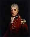
Sir Vernon Haddon Treatt KBE, MM, QC (15 May 1897 – 20 September 1984) was an Australian lawyer, soldier, Rhodes Scholar and politician. Born in Singleton, New South Wales and educated at Shore School, Treatt interrupted his studies at the University of Sydney to enlist at the outbreak of the First World War. Serving in the Royal Australian Artillery, Treatt served in France and was awarded the Military Medal. Upon returning to Australia he was awarded a Rhodes scholarship and further educated at New College, Oxford.
After briefly practising law in 1923 in Britain, Treatt returned to Australia and was admitted to the New South Wales bar that same year, serving as a Crown Prosecutor at the supreme court. Treatt also was the Challis law lecturer at the University of Sydney. Treatt entered the New South Wales Legislative Assembly on 26 March 1938, representing the Electoral district of Woollahra for the United Australia Party (UAP). When UAP Premier Bertram Stevens was ousted from the leadership in August 1939 and Alexander Mair became Premier, Mair appointed Treatt, after serving only a few months in Parliament, as the Minister for Justice. He served in this office until the UAP lost power in 1941. (Full article...) -
St James' Church, commonly known as St James', King Street, is an Australian heritage-listed Anglican parish church located at 173 King Street, in the Sydney central business district in New South Wales. Consecrated in February 1824 and named in honour of St James the Great, it became a parish church in 1835. Designed in the style of a Georgian town church by the transported convict architect Francis Greenway during the governorship of Lachlan Macquarie, St James' is part of the historical precinct of Macquarie Street which includes other early colonial era buildings such as the World Heritage listed Hyde Park Barracks.
The church remains historically, socially and architecturally significant. The building is the oldest one extant in Sydney's inner city region. It was added to the New South Wales State Heritage Register on 3 September 2004; and was listed on the (now defunct) Register of the National Estate. (Full article...) -
Monaro Highway is a 285-kilometre-long (177 mi) highway in Victoria, New South Wales, and the Australian Capital Territory, in Australia, linking Cann River in Victoria to Canberra in the Australian Capital Territory (ACT) via the Monaro region. From its southern terminus, it follows the nearby Cann River upstream towards the New South Wales border through heavily forested terrain. Within New South Wales (NSW), it makes its way through further forest before reaching the pastures typical of the Monaro. There are multiple towns and villages along the highway, including Bombala, Nimmitabel, and Cooma. The terrain within the Monaro is largely hilly, and there are numerous crossings. The road also parallels the former Bombala railway line in several locations. Within the ACT, the road becomes a high volume roadway and serves the southern suburbs of Canberra. The highway has more recently had a grade-separated dual carriageway extension constructed within Canberra, as part of the Eastern Parkway construction project. It is designated part of route M23, and route A23 within Canberra, and route B23 within Victoria and New South Wales, with a concurrency where it also carries route B72 between the two sections of Snowy Mountains Highway. (Full article...) -
Lester Joseph Brain, AO, AFC (27 February 1903 – 30 June 1980) was a pioneer Australian aviator and airline executive. Born in New South Wales, he trained with the Royal Australian Air Force (RAAF) before joining Queensland and Northern Territory Aerial Services (Qantas) as a pilot in 1924. He was awarded the Air Force Cross in 1929, after locating the lost aircraft Kookaburra in northern Australia. Having risen to Chief Pilot at Qantas by 1930, he was appointed Flying Operations Manager in 1938. As a member of the RAAF reserve, Brain coordinated his airline's support for the Australian military during World War II. He earned a King's Commendation for his rescue efforts during an air raid on Broome, Western Australia, in 1942, and was promoted to wing commander in 1944.
Seeing little prospect for advancement at Qantas once the war had ended, Brain left to join the fledgling government-owned domestic carrier Trans Australia Airlines (TAA) in June 1946. Appointed its first General Manager, he swiftly built up the organisation to the stage where it could commence scheduled operations later in the year. By the time he resigned in March 1955, TAA was firmly established as one half of the Commonwealth government's two-airline system. After his departure from TAA, Brain became Managing Director of de Havilland Aircraft in Sydney, before joining the board of East-West Airlines as a consultant in January 1961. He was appointed an Officer of the Order of Australia in January 1979 and died in June the following year, aged seventy-seven. (Full article...) -
Wagga Wagga (/ˌwɒɡə ˈwɒɡə/; informally called Wagga) is a major regional city in the Riverina region of New South Wales, Australia. Straddling the Murrumbidgee River, with an urban population of more than 57,003 as of 2021, Wagga Wagga is the state's second largest inland city after Maitland, and is an important agricultural, military, and transport hub of Australia. The ninth largest inland city in Australia, Wagga Wagga is located midway between the two largest cities in Australia—Sydney and Melbourne—and is the major regional centre for the Riverina and South West Slopes regions.
The central business district is focused around the commercial and recreational grid bounded by Best and Tarcutta Streets and the Murrumbidgee River and the Sturt Highway. The main shopping street of Wagga is Baylis Street which becomes Fitzmaurice Street at the northern end. Wagga is accessible from Sydney via the Sturt and Hume Highways, Adelaide via the Sturt Highway and Albury and Melbourne via the Olympic Highway and Hume Highway. Wagga is in an alluvial valley and much of the city has a problem with urban salinity. (Full article...) -
From 31 May to 8 June 1942, during World War II, Imperial Japanese Navy submarines made a series of attacks on the Australian cities of Sydney and Newcastle. On the night of 31 May – 1 June, three Ko-hyoteki-class midget submarines, (M-14, M-21 and M-24) each with a two-member crew, entered Sydney Harbour, avoided the partially constructed Sydney Harbour anti-submarine boom net, and attempted to sink Allied warships. Two of the midget submarines were detected and attacked before they could engage any Allied vessels. The crew of M-14 scuttled their submarine, whilst M-21 was successfully attacked and sunk. The crew of M-21 killed themselves. These submarines were later recovered by the Allies. The third submarine attempted to torpedo the heavy cruiser USS Chicago, but instead sank the converted ferry HMAS Kuttabul, killing 21 sailors. This midget submarine's fate was unknown until 2006, when amateur scuba divers discovered the wreck off Sydney's northern beaches.
Immediately following the raid, the five Japanese fleet submarines that carried the midget submarines to Australia embarked on a campaign to disrupt merchant shipping in eastern Australian waters. Over the next month, the submarines attacked at least seven merchant vessels, sinking three ships and killing 50 sailors. During this period, between midnight and 02:30 on 8 June, two of the submarines bombarded the ports of Sydney and Newcastle. (Full article...) -

Grevillea juniperina, commonly known as juniper- or juniper-leaf grevillea or prickly spider-flower, is a plant of the family Proteaceae native to eastern New South Wales and southeastern Queensland in Australia. Scottish botanist Robert Brown described the species in 1810, and seven subspecies are recognised. One subspecies, G. j. juniperina, is restricted to Western Sydney and environs and is threatened by loss of habitat and housing development.
A small, prickly-leaved shrub between 0.2–3 m (0.66–9.84 ft) high, G. juniperina generally grows on clay-based or alluvial soils in eucalypt woodland. The flower heads, known as inflorescences, appear from winter to early summer and are red, orange or yellow. Birds visit and pollinate the flowers. Grevillea juniperina plants are killed by bushfire, regenerating afterwards from seed. Grevillea juniperina adapts readily to cultivation and has been important in horticulture as it is the parent of many popular garden hybrids. (Full article...) -
The Inbetweeners 2 is a 2014 teen coming of age adventure sex comedy film and sequel to The Inbetweeners Movie (2011), which is based on the E4 sitcom The Inbetweeners. It was written and directed by series creators Damon Beesley and Iain Morris.
The film involves four school friends who meet up again for a holiday in Australia, and stars Simon Bird, Joe Thomas, James Buckley and Blake Harrison. In media interviews, the film's writers and actors stated that it was to be an end to the series. (Full article...) -
St. John's Orphanage, sometimes referred to as the Goulburn Boys Orphanage, was an orphanage located on Mundy Street in Goulburn, a town located in New South Wales, Australia. The architect of the building was EC Manfred. The foundation stone was laid and blessed on 17 March 1912 by Bishop John Gallagher of Goulburn, who also blessed the building during its opening ceremony in late 1913. It was two storeys high, and several extensions were added to the building throughout its early history. The orphanage amalgamated with St. Joseph's Orphanage for girls in 1976, and the remaining orphans were placed into group homes. As a result, the orphanage was closed in 1978 and rented out to the Youth with a Mission Base until they left in 1994. Since then, the orphanage remained abandoned, until its demolition in 2023.
Run by the Sisters of Mercy and the Catholic Church until its closure, the orphanage housed males from the ages of 5 to 16 initially. Its capacity was intended to be 100 children, but this peaked to more than 200 during the Second World War. By the 1970s, the orphanage began taking in female orphans from St. Joseph's because of declining numbers of males. Until its closure, the orphanage took in more than 2,500 individuals for various reasons. Only four per cent of those who stayed there were actually orphans. The orphanage's residents were given a religious education, and were trained in agriculture. Accounts by former residents state that they suffered severe beatings and punishments, and that they were issued a single set of clothing that was rarely washed. Another claims that some residents endured sexual abuse and rape, not only by the staff, but by older boys, and the caretaker. However, others state that the nuns were tough but fair and remained in contact with them. (Full article...) -
The Point Stephens Light is a heritage-listed active lighthouse located on Point Stephens, a point on an unnamed headland at the east of Fingal Bay, 4.25 km (2.64 mi) south of the entrance of Port Stephens, New South Wales, Australia. The light serves to assist vessels entering Port Stephens. It is considered an endangered lighthouse due to remote location and old age.
Proposed in 1857, the heritage-listed lighthouse was built in 1862. Designed by Alexander Dawson, the New South Wales Government Architect at that time, both the lighthouse's flared base and the keeper's cottages combined terrace are unique architectural features for the period. The light source used was originally kerosene lamps, which upgraded in 1912 to a Dalén light, upgraded again to electric light in 1960, automated in 1973, and finally converted to solar power in 1990. In 1991, the last caretaker withdrew from the premises and very soon after the keeper's cottages were vandalised and burned. (Full article...)


.jpg)


Selected image

The Australian 4th Division was formed in the First World War during the expansion of the Australian Imperial Force infantry brigades in February 1916.
On 11 April 1917 the Fourth Division assaulted the Hindenburg Line in the First Battle of Bullecourt. The battle was a disaster and 1170 Australian prisoners were taken by the Germans. In June it participated in the Battle of Messines. In September it participated in the Battle of Polygon Wood.
The photo depicts soldiers from the New South Wales-based 45th Battalion of the Division during the Hindenburg Line assault.
Related portals

(Northern
Territory) |
WikiProjects
Selected articles -
-
Tamworth is a city and administrative centre of the north-eastern region of New South Wales, Australia. Situated on the Peel River within the local government area of the Tamworth Regional Council, it is the largest and most populated city in the region, with a population of 43,874 in 2021, making it the second largest inland city in New South Wales. Tamworth is 318 km (198 mi) from the Queensland border and is located almost midway between Brisbane and Sydney.
The city is known as the "First Town of Lights", being the first place in Australia to use electric street lights in 1888. Tamworth is also famous as the "Country Music Capital of Australia" and "Australia's answer to Nashville", annually hosting the Tamworth Country Music Festival in late January; the second-biggest country music festival in the world after Nashville. The city is recognised as the National Equine Capital of Australia because of the high number of equine events held in the city and the construction of the world-class Australian Equine and Livestock Events Centre, the biggest of its kind in the Southern Hemisphere. (Full article...) -
Campbelltown is a suburb located on the outskirts of the metropolitan area of Sydney, New South Wales, Australia. It is located in Greater Western Sydney 53 kilometres (33 mi) south-west of the Sydney central business district by road. Campbelltown is the administrative seat of the local government area of the City of Campbelltown. It is also acknowledged on the register of the Geographical Names Board of New South Wales as one of only four cities within the Sydney metropolitan area.
Campbelltown gets its name from Elizabeth Campbell, the wife of former Governor of New South Wales Lachlan Macquarie. Originally called Campbell-Town, the name was later simplified to the current Campbelltown. (Full article...) -
The Sydney Opera House is a multi-venue performing arts centre in Sydney, New South Wales, Australia. Located on the foreshore of Sydney Harbour, it is widely regarded as one of the world's most famous and distinctive buildings and a masterpiece of 20th-century architecture.
Designed by Danish architect Jørn Utzon, but completed by an Australian architectural team headed by Peter Hall, the building was formally opened by Queen Elizabeth II on 20 October 1973, 16 years after Utzon's 1957 selection as winner of an international design competition. The Government of New South Wales, led by the premier, Joseph Cahill, authorised work to begin in 1958 with Utzon directing construction. The government's decision to build Utzon's design is often overshadowed by circumstances that followed, including cost and scheduling overruns as well as the architect's ultimate resignation. (Full article...) -
Johnson's Building is a heritage-listed former retail stores and now stock exchange offices, bar and restaurant located at 233–235 George Street in the inner city Sydney suburb of The Rocks in the City of Sydney local government area of New South Wales, Australia. It was designed by Walter Liberty Vernon and built in 1912. It is also known as Chamber of Commerce Building and Johnson's Overalls Building (Johnsons). The property is owned by Property NSW, an agency of the Government of New South Wales. It was added to the New South Wales State Heritage Register on 10 May 2002. (Full article...) -

Pacific Highway is a 790-kilometre-long (491 mi) national highway and major transport route along the central east coast of Australia, with the majority of it being part of Australia's Highway 1. The highway and its adjoining Pacific Motorway between Brisbane and Brunswick Heads and Pacific Motorway between Sydney and Newcastle links the state capitals of Sydney in New South Wales with Brisbane in Queensland, approximately paralleling the Tasman Sea and the Coral Sea of the South Pacific Ocean coast, via regional cities and towns like Gosford (Central Coast NSW), Newcastle, Taree, Port Macquarie, Kempsey, Coffs Harbour, Grafton, Ballina, Byron Bay, Tweed Heads and the Gold Coast, which is part of Queensland. Additionally, between Brunswick Heads and Port Macquarie (excluding a short stretch around Coffs Harbour), the road is also signed as Pacific Motorway, but has not been legally gazetted as such.
Pacific Highway no longer includes former sections of the highway between Brunswick Heads and Brisbane that have been legally renamed. As such, the highway stops short of the Queensland border near the Gold Coast. It is one of the busiest highways in Australia and was reconstructed as a controlled-access highway (motorway) and limited-access road (dual carriageway) standards between Hexham and the Queensland border between 1996 and December 2020, excepting a portion of remnant surface road around Coffs Harbour, with major construction of the Coffs Harbour Bypass expected to commence in 2023. (Full article...) -
The Parliament of New South Wales, formally the Legislature of New South Wales, is the bicameral legislative body of the Australian state of New South Wales (NSW). It consists of the monarch, the New South Wales Legislative Assembly (lower house) and the New South Wales Legislative Council (upper house). Each house is directly elected by the people of New South Wales at elections held approximately every four years. The legislative authority of the parliament derives from section 5 of the Constitution Act 1902 (NSW). The power to make laws that apply to New South Wales is shared with the Federal (or Commonwealth) Parliament. The houses of the New South Wales Parliament follow the Westminster parliamentary traditions of dress, Green–Red chamber colours and protocols. The houses of the legislature are located in Parliament House on Macquarie Street, Sydney. (Full article...) -
Tom Uglys Bridge are two road bridges, completed in 1929 and 1987, that carry the Princes Highway across the Georges River in southern Sydney, in the state of New South Wales, Australia. The bridges link the St George area at Blakehurst to the Sutherland Shire at Sylvania. Tom Uglys Bridge is one of six major road crossings of Georges River.
The 1929 Pratt truss bridge is listed on the New South Wales State Heritage Register and carries three lanes of northbound vehicular traffic on the Princes Highway. The 1987 concrete box girder bridge was built to the east of the older bridge and carries the three southbound lanes of the highway. Both bridges have shared bicycle and pedestrian pathways. (Full article...) -
New England is a geographical region in the north of the state of New South Wales, Australia, about 60 km inland from the Tasman Sea. The area includes the Northern Tablelands (or New England Tablelands) and the North West Slopes regions. As of 2021, New England had a population of 185,560, with over a quarter of the people living in the area of Tamworth Regional Council. (Full article...) -
The Parramatta River is an intermediate tide-dominated, drowned valley estuary located in Sydney, New South Wales, Australia. With an average depth of 5.1 metres (17 ft), the Parramatta River is the main tributary of Sydney Harbour, a branch of Port Jackson. Secondary tributaries include the smaller Lane Cove and Duck rivers.
Formed by the confluence of Toongabbie Creek and Darling Mills Creek at North Parramatta, the river flows in an easterly direction to a line between Yurulbin in Birchgrove and Manns Point in Greenwich. Here it flows into Port Jackson, about 21 kilometres (13 mi) from the Tasman Sea. The total catchment area of the river is approximately 252.4 square kilometres (97.5 sq mi) and is tidal to Charles Street Weir in Parramatta, approximately 30 kilometres (19 mi) from the Sydney Heads. (Full article...) -
The University of Sydney (USYD) is a public research university in Sydney, Australia. Founded in 1850, it is the oldest university in both Australia and Oceania. One of Australia's six sandstone universities, it was one of the world's first universities to admit students solely on academic merit, and opened its doors to women on the same basis as men. The university comprises eight academic faculties and university schools, through which it offers bachelor, master and doctoral degrees.
Five Nobel and two Crafoord laureates have been affiliated with the university as graduates and faculty. The university has educated eight Australian prime ministers, including incumbent Anthony Albanese; two governors-general of Australia; 13 premiers of New South Wales; and 26 justices of the High Court of Australia, including five chief justices. The university has produced 110 Rhodes Scholars and 19 Gates Scholars. The University of Sydney is a member of the Group of Eight, CEMS, the Association of Pacific Rim Universities and the Association of Commonwealth Universities. (Full article...) -
Goulburn (/ˈɡoʊlbərn/ GOHL-bərn) is a regional city in the Southern Tablelands of New South Wales, Australia, approximately 195 kilometres (121 mi) south-west of Sydney and 90 kilometres (56 mi) north-east of Canberra. It was proclaimed as Australia's first inland city through letters patent by Queen Victoria in 1863. Goulburn had a population of 24,565 as of the 2021 census. Goulburn is the seat of Goulburn Mulwaree Council.
Goulburn is a railhead on the Main Southern line, and regional health & government services centre, supporting the surrounding pastoral industry as well as being a stopover for travellers on the Hume Highway. It has a central historic park and many historic and listed buildings. It is also home to the monument the Big Merino, a sculpture that is the world's largest concrete-constructed sheep. (Full article...) -
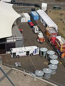
The New South Wales Police Force strip search scandal refers to an ongoing policing scandal surrounding the routine and arbitrary use of strip searches by members of the New South Wales Police Force.
Particular concern has centred around the use of strip searches "in the field", the term used by NSW Police to describe the practice of conducting strip searches outside of a police station. Following the introduction of a controversial law in 2001, police in New South Wales were given the power to deploy specially trained drug detection dogs at large scale public events, licensed venues, and on selected routes across Sydney's public transport network. In 2006, a review published by the New South Wales Ombudsman found that there were significant issues relating to their use, including civil liberties concerns, false positives, and low rates of accuracy. The report noted that during a two-year period between February 2002 and February 2004, NSW Police had conducted 10,211 personal searches resulting from positive drug detection dog indications. Most of those searches had either been a pat down or a search of a person's belongings, however in several cases, officers had made the decision to proceed to a strip search. The Ombudsman noted that such incidents were rare at the time. (Full article...) -
Maitland (/ˈmeɪtlənd/) is a city in the Hunter Valley of New South Wales, Australia and the seat of Maitland City Council, situated on the Hunter River approximately 166 kilometres (103 mi) by road north of Sydney and 35 km (22 mi) north-west of Newcastle. It is on the New England Highway approximately 17 km (11 mi) from its origin at Hexham.
At the 2021 census it had approximately 89,597 inhabitants, spread over an area of 392 square kilometres (151 sq mi), with most of the population located in a strip along the New England Highway between the suburbs of Lochinvar and Thornton respectively. The city centre is located on the right bank of the Hunter River, protected from moderate potential flooding by a levee. (Full article...) -
The Sir John Sulman Medal for Public Architecture is an architectural award presented by the New South Wales chapter of the Australian Institute of Architects since 1932. The medal is sometimes referred to as the Sulman Award and now recognises excellence in public buildings in either New South Wales or in the Australian Capital Territory. Before the advent of the Wilkinson Award in 1961 it was on occasions presented to domestic projects.
The medal is presented in memory of the Australian architect Sir John Sulman (29 August 1849 – 18 August 1934). Sulman was born in Greenwich, England, and emigrated to Sydney in 1885. From 1921 to 1924 he was chairman of the Federal Capital Advisory Committee and influenced the development of Canberra. (Full article...) -
Cabbage Tree Island may refer to three locations in New South Wales, Australia:
- Cabbage Tree Island, New South Wales, a settlement in Ballina Shire
- Cabbage Tree Island (John Gould Nature Reserve), an island and nature reserve near Port Stephens
- Cabbage Tree Island, near Old Bar in the Manning River Entrance State Park, NSW


_Johnsons_Building.JPG)


Did you know (auto-generated)

- ... that Victorian post office official William Rundell also collected stamps in his spare time, acquiring 48 copies of the "Sydney view" stamps of New South Wales?
- ... that the "Cuddle with a Koala" experience at Featherdale Wildlife Park was stopped in 1988 when New South Wales law was changed to restrict koala handling?
- ... that Turkish international soccer player Rojin Polat was named member of the "2021 All Schools Merit Girls Team" in New South Wales, Australia?
General images -
-
 Tumut 3 Power Station was constructed as part of the vast Snowy Mountains Scheme in New South Wales (1949–1974). Construction necessitated the expansion of Australia's immigration program. (from History of New South Wales)
 -
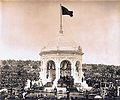 Federation Pavilion, Centennial Park, Sydney, 1 January 1901. (from History of New South Wales)
 -
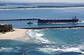 A bulk carrier entering the Port of Newcastle, New South Wales, 2009 (from Economy of New South Wales)
 -
 Dry paddocks in the Riverina region during the 2007 drought (from History of New South Wales)
 -

-
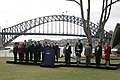 World leaders with Prime Minister John Howard in Sydney for the 2007 APEC conference (from History of New South Wales)
 -

-
 The 5th Governor of New South Wales, Lachlan Macquarie, was influential in establishing civil society in Australia (from History of New South Wales)
 -

-
 A chart of part of the interior of New South Wales by John Oxley, Surveyor General, 1822 (from History of New South Wales)
 -
 Ribbon ceremony to open the Sydney Harbour Bridge on 20 March 1932. Breaking protocol, the soon to be dismissed Premier Jack Lang cuts the ribbon while Governor Philip Game looks on. (from History of New South Wales)
 -
 Aboriginal tribes in New South Wales, from an 1892 map (from History of New South Wales)
 -
 Landing of Lieutenant James Cook at Botany Bay, 29 April 1770 (from History of New South Wales)
 -
 A General Chart of New Holland including New South Wales & Botany Bay with The Adjacent Countries and New Discovered Lands, published in An Historical Narrative of the Discovery of New Holland and New South Wales, London, Fielding and Stockdale, November 1786 (from History of New South Wales)
 -
 Early expeditions of Charles Sturt (from History of New South Wales)
 -
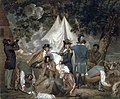 Founding of the settlement of Port Jackson at Botany Bay in New South Wales in 1788 - Thomas Gosse (from History of New South Wales)
 -
 Murray Grey cows and calves (from Economy of New South Wales)
 -
 William Wentworth was key in the establishment of self-governance in New South Wales (from History of New South Wales)
 -
 Mr E.H. Hargraves, The Gold Discoverer of Australia, returning the salute of the gold miners - Thomas Tyrwhitt Balcombe, 1851 (from History of New South Wales)
 -
 Humanitarian Caroline Chisholm provided support to poverty-stricken women migrants (from History of New South Wales)
 -
 Olympic colours on the Sydney Harbour Bridge in the year 2000 (from History of New South Wales)
 -
 Bondi Beach circa 1900 (from History of New South Wales)
 -
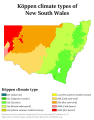 Köppen climate types in New South Wales (from Geography of New South Wales)
 -
 Hyde Park, Sydney with the Australian Museum under construction in the distance, 1842 (from History of New South Wales)
 -
 Governor Arthur Phillip hoists the British flag over the new colony at Sydney in 1788 (from History of New South Wales)
 -
 The Sydney Opera House was opened in 1973. (from History of New South Wales)
 -
 A 630 lb gold specimen from Hill End, unearthed in 1872 (from History of New South Wales)


.jpg)


.jpg)


.jpg)


Topics
Categories

More portals
In the news
- 10 June 2024 – Israel–Hamas war
- The United States Consulate General in Sydney, Australia, is vandalized by a pro-Palestinian activist. (NBC News)
Associated Wikimedia
The following Wikimedia Foundation sister projects provide more on this subject:
-
 Commons
Free media repository -
 Wikibooks
Free textbooks and manuals -
 Wikidata
Free knowledge base -
 Wikinews
Free-content news -
 Wikiquote
Collection of quotations -
 Wikisource
Free-content library -
 Wikiversity
Free learning tools -
 Wikivoyage
Free travel guide -
 Wiktionary
Dictionary and thesaurus


