
Picture Puzzle
| Picture Puzzle | |
|---|---|
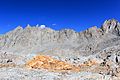
 South aspect, from Bishop Pass | |
| Highest point | |
| Elevation | 13,286+ ft (4050+ m)[1] |
| Prominence | 600 ft (183 m)[1] |
| Parent peak | Cloudripper (13,525 ft)[2] |
| Isolation | 1.12 mi (1.80 km)[2] |
| Coordinates | 37°07′40″N 118°32′20″W / 37.1279154°N 118.5388440°W[3] |
| Geography | |
 Picture Puzzle Location in California  Picture Puzzle Picture Puzzle (the United States) | |
| Country | United States |
| State | California |
| County | Inyo |
| Protected area | John Muir Wilderness |
| Parent range | Sierra Nevada Inconsolable Range[1] |
| Topo map | USGS Mount Thompson |
| Geology | |
| Age of rock | Cretaceous |
| Type of rock | Inconsolable Quartz Monzodiorite[4] |
| Climbing | |
| First ascent | 1937 by Norman Clyde[5] |
| Easiest route | Exposed scramble, class 3[5] |
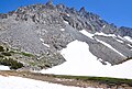
Picture Puzzle, also known as Picture Puzzle Peak, is a 13,297-foot-elevation (4,053 meter) mountain summit located one mile east of the crest of the Sierra Nevada mountain range in Inyo County of northern California, United States.[3] [6] It is situated in the Palisades area of the John Muir Wilderness, on land managed by Inyo National Forest. It is approximately 14.5 miles (23.3 km) west of the community of Big Pine, one mile north of Bishop Pass, 0.8 miles (1.3 km) northwest of Aperture Peak, 1.2 miles (1.9 km) north-northwest of Mount Agassiz, and 1.1 miles (1.8 km) south-southwest of parent Cloudripper. Picture Puzzle ranks as the 90th-highest summit in California,[2] and the third-highest peak of the Inconsolable Range.[1]
Climbing[edit]
Established climbing routes on Picture Puzzle:[5]
- Northeast Couloir – class 3
- North Slope – class 3
- West Face – class 4
The first ascent of the summit was made June 15, 1937, by Norman Clyde, who is credited with 130 first ascents, most of which were in the Sierra Nevada.[7][5]
Climate[edit]
According to the Köppen climate classification system, Picture Puzzle is located in an alpine climate zone.[8] Most weather fronts originate in the Pacific Ocean, and travel east toward the Sierra Nevada mountains. As fronts approach, they are forced upward by the peaks, causing them to drop their moisture in the form of rain or snowfall onto the range (orographic lift). Precipitation runoff from this mountain drains east into headwaters of North Fork Big Pine Creek, and west into headwaters of South Fork Bishop Creek.
Gallery[edit]
-
 South aspect
 -

-
 Picture Puzzle by Ansel Adams ca. 1936
 -
 Picture Puzzle (left) and Aperture Peak (right)
 -
 Picture Puzzle from northwest
 -


,%22_California,_1936.,_ca._1936_-_NARA_-_519918.jpg)


See also[edit]
References[edit]
- ^ a b c d "Picture Puzzle Peak, California". Peakbagger.com. Retrieved 2021-04-20.
- ^ a b c "Picture Puzzle CA". ListsOfJohn.com. Retrieved 2021-04-20.
- ^ a b "Picture Puzzle". Geographic Names Information System. United States Geological Survey, United States Department of the Interior. Retrieved 2021-04-20.
- ^ Stratotype Inventory—Sequoia and Kings Canyon National Parks, California, nps.gov
- ^ a b c d Secor, R.J. (2009). The High Sierra Peaks, Passes, and Trails (3rd ed.). Seattle: The Mountaineers. p. 203. ISBN 978-0898869712.
- ^ Steve Roper, The Climber's Guide to the High Sierra, 1976, Sierra Club Books, ISBN 9780871561473, page 195.
- ^ "Norman Clyde - Mountaineer". OwensValleyHistory.com.
- ^ Peel, M. C.; Finlayson, B. L.; McMahon, T. A. (2007). "Updated world map of the Köppen−Geiger climate classification". Hydrol. Earth Syst. Sci. 11. ISSN 1027-5606.
External links[edit]
- Weather forecast: Picture Puzzle
- Picture Puzzle from Chocolate Peak: Flickr photo
- Cloudripper and Picture Puzzle: Flickr photo