
Pine Mountain (San Bernardino County, California)
| Pine Mountain | |
|---|---|
 Northwest aspect of Pine Mountain (center) | |
| Highest point | |
| Elevation | 9,652 ft (2,942 m)[1][2] |
| Prominence | 862 ft (263 m)[1] |
| Parent peak | Mount San Antonio (10,064 ft)[3] |
| Isolation | 1.70 mi (2.74 km)[3] |
| Listing | Hundred Peaks Section[4] |
| Coordinates | 34°18′49″N 117°38′39″W / 34.3135735°N 117.6441656°W[5] |
| Geography | |
 Pine Mountain Location in California  Pine Mountain Pine Mountain (the United States) | |
| Country | United States |
| State | California |
| County | San Bernardino |
| Protected area | San Gabriel Mountains National Monument[6] Sheep Mountain Wilderness |
| Parent range | San Gabriel Mountains[2] |
| Topo map | USGS Mount San Antonio |
| Geology | |
| Mountain type | Fault block |
| Climbing | |
| Easiest route | North Backbone Trail[2] |
Pine Mountain is a 9,652-foot-elevation (2,942 meter) summit located in the San Gabriel Mountains, in San Bernardino County, California, United States.
Description[edit]
Pine Mountain is set approximately 40 miles (64 km) northeast of downtown Los Angeles within San Gabriel Mountains National Monument and the Sheep Mountain Wilderness. It ranks as the second-highest peak in the San Gabriel Mountains,[1] second-highest in the wilderness and monument, and the 10th-highest in the county.[3] Topographic relief is significant as the summit rises 2,650 feet (808 meters) above North Fork Lytle Creek in approximately one mile (1.6 km). Reaching the summit involves 6.5 miles of trail hiking with 1,600 feet of elevation gain.[7] The mountain was named by the US Forest Service for the dense stand of Jeffrey Pine and white fir covering the slopes.[8] This landform's toponym has been officially adopted by the U.S. Board on Geographic Names and first appeared in 1901.[5]
Climate[edit]
According to the Köppen climate classification system, Pine Mountain is located in a continental climate zone (Dsa) with mostly dry summers (except for scattered summer thunderstorms) and cold, wet winters.[9] Most weather fronts originating in the Pacific Ocean travel east toward the San Gabriel Mountains. As fronts approach, they are forced upward by the peaks (orographic lift), causing them to drop their moisture onto the range. Precipitation runoff from this mountain's west slopes drains to the San Gabriel River and the east slope drains into Lytle Creek.
See also[edit]
Gallery[edit]
-
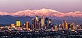
 Los Angeles with Pine Mountain to left, Mount San Antonio (aka Baldy) to right
 -
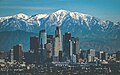
 Los Angeles with Pine Mountain to left of center, Mount San Antonio center
 -
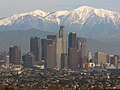
 Los Angeles with Pine Mountain to left, Mount San Antonio (aka Baldy) center
 -
 View from the summit of Mount Baden-Powell. Pine Mountain to left and Mount San Antonio (aka Baldy) to right.
 -
 Los Angeles with Pine Mountain to left, Mount San Antonio (aka Baldy) to right


.jpg)
References[edit]
- ^ a b c "Pine Mountain, California". Peakbagger.com. Retrieved 2024-05-26.
- ^ a b c "Pine Mountain, Peakvisor.com". Retrieved 2024-05-26.
- ^ a b c "Pine Mountain - 9,648' CA". listsofjohn.com. Retrieved 2024-05-26.
- ^ "Pine Mountain #1". Hundred Peaks Section List. Angeles Chapter, Sierra Club.
- ^ a b "Pine Mountain". Geographic Names Information System. United States Geological Survey, United States Department of the Interior. Retrieved 2024-05-26.
- ^ San Gabriel Mountains National Monument Map, US Forest Service, Retrieved 2024-05-26.
- ^ Allen Riedel, 100 Classic Hikes in Southern California, The Mountaineers Books, 2008, ISBN 9781594851254, p. 95.
- ^ 16C Pine Mountain #1, Hundred Peaks Section, Sierra Club, Retrieved 2024-05-26.
- ^ "San Gabriel Mountains, Peakvisor.com". Retrieved 2024-05-22.
Places adjacent to Pine Mountain (San Bernardino County, California) | ||||||||||||||||
|---|---|---|---|---|---|---|---|---|---|---|---|---|---|---|---|---|
| ||||||||||||||||