
Poienile de sub Munte
This article needs additional citations for verification. (March 2020) |
Poienile de sub Munte
Русь Поляни | |
|---|---|
 Poenile de sub Munte from nearby massif in northeast | |
 Location in Maramureș County | |
 Poienile de sub Munte Location in Romania | |
| Coordinates: 47°49′N 24°26′E / 47.817°N 24.433°E | |
| Country | Romania |
| County | Maramureș |
| Established | 1353 (first attested) |
| Government | |
| • Mayor (2020–2024) | Alexa Chifa[1] (USR) |
| Area | 293.36 km2 (113.27 sq mi) |
| Elevation | 530 m (1,740 ft) |
| Highest elevation | 1,957 m (6,421 ft) |
| Population (2021-12-01)[2] | 9,291 |
| • Density | 32/km2 (82/sq mi) |
| Time zone | EET/EEST (UTC+2/+3) |
| Postal code | 437220 |
| Area code | (+40) 02 62 |
| Vehicle reg. | MM |
| Website | www |
Poienile de sub Munte (Ukrainian: Русь Поляни, Поляни or Полонина; Rusyn: Русь Поляни; Hungarian: Ruszpolyána or Havasmező; Polish: Ruska Polana; German: Reußenau; Yiddish: פאליען-ריסקווה, romanized: Polien Riskeve) is a commune in Maramureș County, Maramureș, Romania. It is one of the oldest places in Maramureș, being mentioned for the first time in 1353. It is the biggest commune in the county and is composed of a single village, Poienile de sub Munte.
Geography[edit]
The commune is located in the northeastern part of Maramureș County, on the border with Ukraine, 60 km (37 mi) east of the city of Sighetu Marmației and 105 km (65 mi) northeast of the county seat, Baia Mare. It is situated at an altitude of 530 m (1,740 ft), nestled within the Maramureș Mountains, with an altitude of 1,957 m (6,421 ft) being reached at Farcău Peak. The Maramureș Mountains Natural Park is partly located on the territory of the commune. The river Ruscova and its tributaries, the rivers Socolău and Cvașnița, flow through Poienile de sub Munte.
Obcina is a Ruthenian hilltop settlement perched at about 1,000 m (3,300 ft) on a mountain pass without an access road, where farmers live without machines, electricity, or vehicles.
Etymology[edit]
Etymology of the name of the locality: from Poiana (< subst. poiana "light in the forest", of Slavic origin) + de + sub + Munte (< appellative mountain < lat. mons, -tis). Literally, The Meadows under the Mountain.
Demographics[edit]
| Year | Pop. | ±% |
|---|---|---|
| 1880 | 3,674 | — |
| 1900 | 4,807 | +30.8% |
| 1910 | 5,226 | +8.7% |
| 1930 | 5,644 | +8.0% |
| 1956 | 6,298 | +11.6% |
| 1977 | 8,776 | +39.3% |
| 1992 | 10,561 | +20.3% |
| 2002 | 10,033 | −5.0% |
| 2011 | 10,073 | +0.4% |
| 2021 | 9,291 | −7.8% |
| Source: Census data | ||
At the 2021 census, the commune had a population of 9,291, of which 90.83% were Ukrainians and 1.54% ethnic Romanians.[3]
Natives[edit]
- Ioan Dzițac (1953 – 2021), mathematician and computer scientist
External links[edit]
- Obcina. Part 1 of the "Ruthenian Trilogy": The most spectacular mountain village of Maramureș on YouTube
- Ukrainian wooden church from Poienile de sub Munte on YouTube
- The world up close, Poienile de sub Munte on YouTube
References[edit]
- ^ "Results of the 2020 local elections". Central Electoral Bureau. Retrieved 14 June 2021.
- ^ "Populaţia rezidentă după grupa de vârstă, pe județe și municipii, orașe, comune, la 1 decembrie 2021" (XLS). National Institute of Statistics.
- ^ "Populația rezidentă după grupa de vârstă, pe județe și municipii, orașe, comune, la 1 decembrie 2021" (in Romanian). INSSE. 31 May 2023.
-
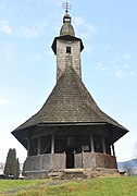 Ukrainian wooden church of the Transfiguration
 -
 The new Ukrainian church
 -
 Stone church
 -
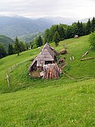 Obcina hamlet


