
Portal:Myanmar
ကြိုဆိုပါတယ်။ / Welcome to the Myanmar Portal 

Myanmar, officially the Republic of the Union of Myanmar and also known as Burma (the official name until 1989), is a country in Southeast Asia. It is the largest country by area in Mainland Southeast Asia and has a population of about 55 million. It is bordered by Bangladesh and India to its northwest, China to its northeast, Laos and Thailand to its east and southeast, and the Andaman Sea and the Bay of Bengal to its south and southwest. The country's capital city is Naypyidaw, and its largest city is Yangon (formerly Rangoon).
Myanmar is a member of the East Asia Summit, Non-Aligned Movement, ASEAN, and BIMSTEC, but it is not a member of the Commonwealth of Nations despite once being part of the British Empire. Myanmar is a Dialogue Partner of the Shanghai Cooperation Organization. The country is very rich in natural resources, such as jade, gems, oil, natural gas, teak and other minerals, as well as also endowed with renewable energy, having the highest solar power potential compared to other countries of the Great Mekong Subregion. However, Myanmar has long suffered from instability, factional violence, corruption, poor infrastructure, as well as a long history of colonial exploitation with little regard to human development. In 2013, its GDP (nominal) stood at US$56.7 billion and its GDP (PPP) at US$221.5 billion. The income gap in Myanmar is among the widest in the world, as a large proportion of the economy is controlled by cronies of the military junta. Myanmar is one of the least developed countries; as of 2020, according to the Human Development Index, it ranks 147 out of 189 countries in terms of human development, the lowest in Southeast Asia. Since 2021, more than 600,000 people were displaced across Myanmar due to the surge in violence post-coup, with more than 3 million people in dire need of humanitarian assistance. (Full article...)
Selected articles -
-
![Image 1 Yangon (Burmese: ရန်ကုန်; pronounced [jàɰ̃.ɡòʊɰ̃]), formerly romanized as Rangoon, is the capital of the Yangon Region and the largest city of Myanmar (also known as Burma). Yangon served as the capital of Myanmar until 2006, when the military government relocated the administrative functions to the purpose-built capital city of Naypyidaw in north central Myanmar. With over five million people, Yangon is Myanmar's most populous city and its most important commercial centre. Yangon boasts the largest number of colonial-era buildings in Southeast Asia, and has a unique colonial-era urban core that is remarkably intact. The colonial-era commercial core is centered around the Sule Pagoda, which is reputed to be over 2,000 years old. The city is also home to the gilded Shwedagon Pagoda – Myanmar's most sacred and famous Buddhist pagoda. (Full article...)](//upload.wikimedia.org/wikipedia/en/d/d2/Blank.png)

Yangon (Burmese: ရန်ကုန်; pronounced [jàɰ̃.ɡòʊɰ̃]), formerly romanized as Rangoon, is the capital of the Yangon Region and the largest city of Myanmar (also known as Burma). Yangon served as the capital of Myanmar until 2006, when the military government relocated the administrative functions to the purpose-built capital city of Naypyidaw in north central Myanmar. With over five million people, Yangon is Myanmar's most populous city and its most important commercial centre.
Yangon boasts the largest number of colonial-era buildings in Southeast Asia, and has a unique colonial-era urban core that is remarkably intact. The colonial-era commercial core is centered around the Sule Pagoda, which is reputed to be over 2,000 years old. The city is also home to the gilded Shwedagon Pagoda – Myanmar's most sacred and famous Buddhist pagoda. (Full article...) -
The Karen (/kəˈrɛn/ kə-REN), also known as the Kayin, Kariang or Kawthoolese, are an ethnolinguistic group of Tibeto-Burman language-speaking people. The group as a whole is heterogeneous and disparate as many Karen ethnic groups do not associate or identify with each other culturally or linguistically. These Karen groups reside primarily in Kayin State, southern and southeastern Myanmar. The Karen account for around 6.69% of the Burmese population. Many Karen have migrated to Thailand, having settled mostly on the Myanmar–Thailand border. A few Karen have settled in the Andaman and Nicobar Islands, India, and other Southeast Asian and East Asian countries.
The Karen groups as a whole are often confused with the Padaung tribe, best known for the neck rings worn by their women, but they are just one sub-group of Red Karens (Karenni), one of the tribes of Kayah in Kayah State, Myanmar. (Full article...) -
General elections were held in Myanmar on 8 November 2015, with the National League for Democracy winning a supermajority of seats in the combined national parliament. Voting occurred in all constituencies, excluding seats appointed by the military, to select Members of Assembly to seats in both the upper house (the House of Nationalities) and the lower house (the House of Representatives) of the Assembly of the Union, and State and Region Hluttaws. Ethnic Affairs Ministers were also elected by their designated electorates on the same day, although only select ethnic minorities in particular states and regions were entitled to vote for them.
These polls were the first openly contested election held in the country since 1990, which was annulled by the military government after the National League for Democracy's (NLD) victory. The poll was preceded by the 2010 general election, which was marred by a boycott and widespread allegations of systematic fraud by the victorious Union Solidarity and Development Party (USDP). (Full article...) -

The British colonial rule in Burma lasted from 1824 to 1948, from the successive three Anglo-Burmese wars through the creation of Burma as a province of British India to the establishment of an independently administered colony, and finally independence. The region under British control was known as British Burma, and officially known as Burma (Burmese: မြန်မာနိုင်ငံတော်) from 1886. Various portions of Burmese territories, including Arakan and Tenasserim, were annexed by the British after their victory in the First Anglo-Burmese War; Lower Burma was annexed in 1852 after the Second Anglo-Burmese War. The annexed territories were designated the minor province (a chief commissionership) of British Burma in 1862.
After the Third Anglo-Burmese War in 1885, Upper Burma was annexed, and the following year, the province of Burma in British India was created, becoming a major province (a lieutenant-governorship) in 1897. This arrangement lasted until 1937, when Burma began to be administered separately by the Burma Office under the Secretary of State for India and Burma. British rule was disrupted during the Japanese occupation of much of the country during World War II. Burma achieved independence from British rule on 4 January 1948. (Full article...) -
Mandalay Region (Burmese: မန္တလေးတိုင်းဒေသကြီး, pronounced [máɰ̃dəlé táiɰ̃ dèθa̰ dʑí]; formerly Mandalay Division) is an administrative division of Myanmar. It is located in the center of the country, bordering Sagaing Region and Magway Region to the west, Shan State to the east, and Bago Region and Kayin State to the south. The regional capital is Mandalay. To the south of the region lies the national capital of Naypyidaw. The division consists of eleven districts, which are subdivided into 28 townships and 2,320 wards and village-tracts.
Mandalay Region is important in Myanmar's economy, accounting for 15% of the national economy. It is under the administration of the Mandalay Region Government. (Full article...) -
The Golden Triangle is a large, mountainous region of approximately 200,000 km2 (77,000 sq mi) in northeastern Myanmar, northwestern Thailand and northern Laos, centered on the confluence of the Ruak and Mekong rivers. The name "Golden Triangle" was coined by Marshall Green, a U.S. State Department official, in 1971 in a press conference on the opium trade. Today, the Thai side of the river confluence, Sop Ruak, has become a tourist attraction, with the House of Opium Museum, a Hall of Opium, and a Golden Triangle Park, and no opium cultivation.
The Golden Triangle has been one of the largest opium-producing areas of the world since the 1950s. Most of the world's heroin came from the Golden Triangle until the early 21st century when opium production in Afghanistan increased. Myanmar was the world's second-largest source of opium after Afghanistan up to 2022, producing some 25% of the world's opium, forming part of the Golden Triangle. While opium poppy cultivation in Myanmar had declined year-on-year since 2015, cultivation area increased by 33% totalling 40,100 ha (99,000 acres) alongside an 88% increase in yield potential to 790 t (780 long tons; 870 short tons) in 2022 according to latest data from the United Nations Office on Drugs and Crime (UNODC) Myanmar Opium Survey 2022. The United Nations Office on Drugs and Crime has also warned that opium production in Myanmar may rise again if the economic crunch brought on by COVID-19 and the country's 2021 Myanmar coup d'état persists, with significant public health and security consequences for much of Asia. (Full article...) -

Japanese troops at Shwethalyaung Buddha, 1942
The Japanese occupation of Burma was the period between 1942 and 1945 during World War II, when Burma was occupied by the Empire of Japan. The Japanese had assisted formation of the Burma Independence Army, and trained the Thirty Comrades, who were the founders of the modern Armed Forces (Tatmadaw). The Burmese hoped to gain support of the Japanese in expelling the British, so that Burma could become independent.
In 1942, Japan invaded Burma and, on 1 August 1943, nominally declared the colony independent as the State of Burma. A pro-Japanese government led by Ba Maw was installed. However, many Burmese began to believe the Japanese had no intention of giving them real independence. (Full article...) -
Insurgencies have been ongoing in Myanmar since 1948, when the country, then known as Burma, gained independence from the United Kingdom. It has largely been an ethnic conflict, with ethnic armed groups fighting Myanmar's armed forces, the Tatmadaw, for self-determination. Despite numerous ceasefires and the creation of autonomous self-administered zones in 2008, armed groups continue to call for independence, increased autonomy, or federalisation. It is the world's longest ongoing civil war, spanning almost eight decades.
In 1940, during World War II, Burmese intellectuals formed the Thirty Comrades, who later established the Burma Independence Army (BIA) to fight against the Allies. Aung San led the State of Burma, switching allegiance to the Allies in mid-1944. Post-war negotiations led to Burma's independence in 1948, but tensions arose as the Panglong Agreement promising autonomy to ethnic minorities, was not honored after Aung San's assassination. This period saw the rise of the Communist Party of Burma and the Karen National Union (KNU). (Full article...) -
The royal chronicles of Myanmar (Burmese: မြန်မာ ရာဇဝင် ကျမ်းများ [mjəmà jàzəwɪ̀ɰ̃ tɕáɰ̃ mjá]; also known as Burmese chronicles) are detailed and continuous chronicles of the monarchy of Myanmar (Burma). The chronicles were written on different media such as parabaik paper, palm leaf, and stone; they were composed in different literary styles such as prose, verse, and chronograms. Palm-leaf manuscripts written in prose are those that are commonly referred to as the chronicles. Other royal records include administrative treatises and precedents, legal treatises and precedents, and censuses.
The chronicle tradition was maintained in the country's four historical polities: Upper Burma, Lower Burma, Arakan and the Shan states. The majority of the chronicles did not survive the country's numerous wars as well as the test of time. The most complete extant chronicles are those of Upper Burma-based dynasties, with the earliest extant chronicle dating from the 1280s and the first standard national chronicle from the 1720s. (Full article...) -
The Kingdom of Pagan (Burmese: ပုဂံခေတ်, pronounced [bəɡàɰ̃ kʰɪʔ], lit. 'Pagan Period'; also known as the Pagan dynasty and the Pagan Empire; also the Bagan dynasty or Bagan Empire) was the first Burmese kingdom to unify the regions that would later constitute modern-day Myanmar. Pagan's 250-year rule over the Irrawaddy valley and its periphery laid the foundation for the ascent of Burmese language and culture, the spread of Bamar ethnicity in Upper Myanmar, and the growth of Theravada Buddhism in Myanmar and in mainland Southeast Asia.
The kingdom grew out of a small 9th-century settlement at Pagan (present-day Bagan) by the Mranma/Burmans. Over the next two hundred years, the small principality gradually grew to absorb its surrounding regions until the 1050s and 1060s when King Anawrahta founded the Pagan Empire, presumably for the first time unifying under one polity the Irrawaddy valley and its periphery. By the late 12th century, Anawrahta's successors had extended their influence farther to the south into the upper Malay Peninsula, to the east at least to the Salween river, in the farther north to below the current China border, and to the west, in northern Arakan and the Chin Hills. In the 12th and 13th centuries, Pagan, alongside the Khmer Empire, was one of two main empires in mainland Southeast Asia. (Full article...)
![Image 1 Yangon (Burmese: ရန်ကုန်; pronounced [jàɰ̃.ɡòʊɰ̃]), formerly romanized as Rangoon, is the capital of the Yangon Region and the largest city of Myanmar (also known as Burma). Yangon served as the capital of Myanmar until 2006, when the military government relocated the administrative functions to the purpose-built capital city of Naypyidaw in north central Myanmar. With over five million people, Yangon is Myanmar's most populous city and its most important commercial centre. Yangon boasts the largest number of colonial-era buildings in Southeast Asia, and has a unique colonial-era urban core that is remarkably intact. The colonial-era commercial core is centered around the Sule Pagoda, which is reputed to be over 2,000 years old. The city is also home to the gilded Shwedagon Pagoda – Myanmar's most sacred and famous Buddhist pagoda. (Full article...)](/wiki/File:Blank.png)


.svg)


Did you know (auto-generated) -

- ... that Molly Burman resumed releasing music three years later after finding that "Happy Things" had accrued a million streams on Spotify?
- ... that Aung Myo Min, Union Minister of Human Rights for the National Unity Government of Myanmar, is the country's first openly LGBT minister?
- ... that the Burmese Buddhist monk Sagyo Thu-Myat successfully lobbied for the recalibration of the Burmese calendar?
- ... that the Myanmar Coast Guard was initially proposed as a civilian law enforcement agency before being established as a branch of the military three years later?
- ... that former Burmese actress Honey Nway Oo turned rebel and took up arms against the military junta following the 2021 Myanmar coup d'état?
- ... that the talabaw soup, which consists primarily of bamboo shoots, is the essential dish of Myanmar's Karen people, who use it to supplement rice?
- ... that the Burmese and South Korean first ladies held their first informal conversation 44 years after the establishment of bilateral relations between the two countries?
- ... that while defending Zaw Myint Maung following his arrest by the Myanmar junta, lawyer Ywet Nu Aung was herself arrested and charged?
Related portals and projects
General images -
-
 A wedding procession, with the groom and bride dressed in traditional Burmese wedding clothes, reminiscent of royal attire (from Culture of Myanmar)
 -
 Portuguese ruler and soldiers mounting an Elephant. Philips, Jan Caspar (draughtsman and engraver) (from History of Myanmar)
 -
 British soldiers remove their shoes at the entrance of Shwedagon Pagoda. To the left, a sign reads "Foot wearing is strictly prohibited" in Burmese, English, Tamil, and Urdu. (from Culture of Myanmar)
 -

-
 Protesters in Yangon carrying signs reading "Free Daw Aung San Suu Kyi" on 8 February 2021. (from History of Myanmar)
 -
 The restored Taungoo or Nyaungyan dynasty c. 1650 CE. (from History of Myanmar)
 -
 Former US President Barack Obama poses barefoot on the grounds of Shwedagon Pagoda, one of Myanmar's major Buddhist pilgrimage sites. (from Culture of Myanmar)
 -
 19th-century funeral cart and spire, which would form part of the procession from the home to the place of cremation (from Culture of Myanmar)
 -

-
 Pagan Kingdom during Narapatisithu's reign. Burmese chronicles also claim Kengtung and Chiang Mai. Core areas shown in darker yellow. Peripheral areas in light yellow. Pagan incorporated key ports of Lower Burma into its core administration by the 13th century. (from History of Myanmar)
 -
 Boxing match, 19th-century watercolour (from Culture of Myanmar)
 -
 Hlei pyaingbwè - a Burmese regatta (from Culture of Myanmar)
 -

-
 Recorder's Court on Sule Pagoda Road, with the Sule Pagoda at the far end, Rangoon, 1868. Photographer: J. Jackson. (from History of Myanmar)
 -
 Grandfather Island, Dawei (from Geography of Myanmar)
 -
 Vegetable stall on the roadside at the Madras Lancer Lines, Mandalay, January 1886. Photographer: Hooper, Willoughby Wallace (1837–1912). (from History of Myanmar)
 -
 Sculpture of Myanmar mythical lion (from Culture of Myanmar)
 -
 The paddle steamer Ramapoora (right) of the British India Steam Navigation Company on the Rangoon river having just arrived from Moulmein. 1895. Photographers: Watts and Skeen (from History of Myanmar)
 -
 Political Map of Burma (Myanmar) c. 1450 CE. (from History of Myanmar)
 -
 A theatrical performance of the Mon dance (from Culture of Myanmar)
 -
 British soldiers dismantling cannons belonging to King Thibaw's forces, Third Anglo-Burmese War, Ava, 27 November 1885. Photographer: Hooper, Willoughby Wallace (1837–1912). (from History of Myanmar)
 -
 A large fracture on the Mingun Pahtodawgyi caused by the 1839 Ava earthquake. (from Geography of Myanmar)
 -
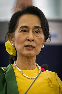
 Aung San Suu Kyi addresses crowds at the NLD headquarters shortly after her release. (from History of Myanmar)
 -
 Myinhkin thabin - equestrian sport (from Culture of Myanmar)
 -
 Myanmar (Burma) map of Köppen climate classification (from Geography of Myanmar)
 -
 Temples at Mrauk U, was the capital of the Mrauk U Kingdom, which ruled over what is now Rakhine State. (from History of Myanmar)
 -
 Mountains near Pindaya on the Shan Plateau (from Geography of Myanmar)
 -
 Mount Popa, a dormant volcano in the Central Lowlands (from Geography of Myanmar)
 -
 A bull fight, 19th-century watercolour (from Culture of Myanmar)
 -
 Salween river at Mae Sam Laep on the Thai-Myanmar border (from Geography of Myanmar)
 -
 Aerial view of a burned Rohingya village in Rakhine state, Myanmar, September 2017 (from History of Myanmar)
 -
 Saint Mary's Cathedral in Downtown Yangon is the largest Roman Catholic cathedral in Burma. (from Culture of Myanmar)
 -
 Jade Mine in Hpakant (from Geography of Myanmar)
 -
 British soldiers on patrol in the ruins of the Burmese town of Bahe during the advance on Mandalay, January 1945. (from History of Myanmar)
 -
 Two female musicians play the saung at a performance in Mandalay. (from Culture of Myanmar)
 -
 A wide range of Burmese lacquerware from Bagan (from Culture of Myanmar)
 -
 The shores of Irrawaddy River at Nyaung-U, Bagan (from Geography of Myanmar)
 -
 A group of Buddhist worshipers at Shwedagon Pagoda, an important religious site for Burmese Buddhists (from Culture of Myanmar)
 -
 Protesters in Yangon with a banner that reads non-violence: national movement in Burmese, in the background is Shwedagon Pagoda. (from History of Myanmar)
 -


_headquarter.jpg)


Major topics
Categories

More topics

Associated Wikimedia
The following Wikimedia Foundation sister projects provide more on this subject:
-
 Commons
Free media repository -
 Wikibooks
Free textbooks and manuals -
 Wikidata
Free knowledge base -
 Wikinews
Free-content news -
 Wikiquote
Collection of quotations -
 Wikisource
Free-content library -
 Wikiversity
Free learning tools -
 Wikivoyage
Free travel guide -
 Wiktionary
Dictionary and thesaurus


