
Portal:Kent/Sandbox
DesktopMobile
Test of: Transclude files as random slideshow/sandbox
-
-
 View of the White Cliffs of Dover from France (from Kent)
 -

-
-
 An early mention of Kent in the Anglo-Saxon Chronicle between 11th and 12th centuries (from Kent)
 -

-
 Canterbury Cathedral (from Kent)
 -
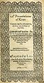 Title page of William Lambarde's Perambulation of Kent (completed in 1570 and published in 1576), a historical description of Kent and the first published county history (from Kent)
 -
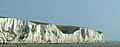 The White Cliffs of Dover (from Kent)
 -
-
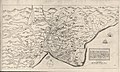
 Hand-drawn map of Kent, Sussex, Surrey and Middlesex from 1575. (from Kent)
 -
 Geological cross-section of Kent, showing how it relates to major towns (from Kent)
 -
 A map of Romney Marsh "The history of imbanking and drayning" by William Dugdale (1662). (from Kent)
 -

-
 The coat of arms of Kent County Council (from Kent)


Apr2006.jpg)


.jpg)


Test of: Transclude linked excerpts as random slideshow/sandbox
-
 Sevenoaks is a town in Kent with a population of 29,506 situated south-east of London, England. Also classified as a civil parish, Sevenoaks is served by a commuter main line railway into London. Sevenoaks is 21 miles (34 km) from Charing Cross, the traditional centre of London. It is the principal town of the Sevenoaks district, followed by Swanley and Edenbridge. (Full article...)
 -
-
Archaic humans is a broad category denoting all species of the genus Homo that are not Homo sapiens (which are known as modern humans). Among the earliest modern human remains are those from Jebel Irhoud in Morocco (about 315 ka), Florisbad in South Africa (259 ka), and Omo-Kibish I (Omo I) in southern Ethiopia (c. 233 or 195 ka). Some examples of archaic humans include H. antecessor (1200–770 ka), H. bodoensis (1200–300 ka), H. heidelbergensis (600–200 ka), Neanderthals (H. neanderthalensis; 430–40 ka), H. rhodesiensis (300–125 ka) and Denisovans (H. denisova; 285–52 ka). (Full article...)
-
Frank Helmut Auerbach (born 29 April 1931) is a German-British painter. Born in Germany, he has been a naturalised British subject since 1947. He is considered one of the leading names in the School of London, with fellow artists Francis Bacon and Lucian Freud. (Full article...)
-
Chalk is a soft, white, porous, sedimentary carbonate rock. It is a form of limestone composed of the mineral calcite and originally formed deep under the sea by the compression of microscopic plankton that had settled to the sea floor. Chalk is common throughout Western Europe, where deposits underlie parts of France, and steep cliffs are often seen where they meet the sea in places such as the Dover cliffs on the Kent coast of the English Channel. (Full article...)
-
The High Weald National Landscape is in south-east England. Covering an area of 1,450 square kilometres (560 sq mi), it takes up parts of Kent,
Surrey, East Sussex, and West Sussex. It is the fourth largest Area of Outstanding Natural Beauty (AONB) in England and Wales. It has an attractive landscape with a mosaic of small farms and woodlands, historic parks, sunken lanes and ridge-top villages. (Full article...) -
Ivor the Engine is a British cutout animation television series created by Oliver Postgate and Peter Firmin's Smallfilms company. It follows the adventures of a small green steam locomotive who lives in the "top left-hand corner of Wales" and works for The Merioneth and Llantisilly Rail Traction Company Limited. His friends include Jones the Steam, Evans the Song and Dai Station, among many other characters. (Full article...)
-
Radio Folkestone, previously known as 105.9 Academy FM until 11 May 2024, is a community radio station serving the town of Folkestone in Kent, which launched on 31 March 2011. (Full article...)
-
95.6 BRFM is a community radio station serving the Isle of Sheppey in Kent which launched on 30 October 2006. (Full article...)
-
The Royal Navy (RN) is the naval warfare force of the United Kingdom, British Overseas Territories and Crown Dependencies, and a component of His Majesty's Naval Service. Although warships were used by English and Scottish kings from the early medieval period, the first major maritime engagements were fought in the Hundred Years' War against France. The modern Royal Navy traces its origins to the early 16th century; the oldest of the UK's armed services, it is consequently known as the Senior Service. (Full article...)
-
Charles John Huffam Dickens (/ˈdɪkɪnz/; 7 February 1812 – 9 June 1870) was an English novelist, journalist, short story writer and social critic. He created some of literature's best-known fictional characters, and is regarded by many as the greatest novelist of the Victorian era. His works enjoyed unprecedented popularity during his lifetime and, by the 20th century, critics and scholars had recognised him as a literary genius. His novels and short stories are widely read today. (Full article...)
-
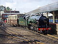
SE Trains Limited, trading as Southeastern, is a British train operating company owned by DfT OLR Holdings for the Department for Transport, that took over operating the South Eastern franchise in South East England from privately owned London & South Eastern Railway (which also traded as Southeastern) on 17 October 2021. (Full article...)
-
Rochester Cathedral, formally the Cathedral Church of Christ and the Blessed Virgin Mary, is in Rochester, Kent, England. The cathedral is the mother church of the Anglican Diocese of Rochester and seat (cathedra) of the Bishop of Rochester, the second oldest bishopric in England after that of the Archbishop of Canterbury. The cathedral, built in the Norman style is a Grade I listed building. (Full article...)
-
Swanley is a town and civil parish in the Sevenoaks District of Kent, England, 16 miles (26 km) southeast of central London, adjacent to the Greater London boundary and within the M25 motorway periphery. The population at the 2021 census was 17,826. (Full article...)
-
The South Eastern and Chatham Railway Companies Joint Management Committee (SE&CRCJMC), known as the South Eastern and Chatham Railway (SE&CR), was a working union of two neighbouring rival railways, the South Eastern Railway (SER) and London, Chatham and Dover Railway (LC&DR), which operated between London and south-east England. Between 1899 and 1923, the SE&CR had a monopoly of railway services in Kent and to the main Channel ports for ferries to France and Belgium. (Full article...)
-
The Thames Estuary is where the River Thames meets the waters of the North Sea, in the south-east of Great Britain. (Full article...)
-
The North Downs are a ridge of chalk hills in south east England that stretch from Farnham in Surrey to the White Cliffs of Dover in Kent. Much of the North Downs comprises two Areas of Outstanding Natural Beauty (AONBs): the Surrey Hills and the Kent Downs. The North Downs Way National Trail runs along the North Downs from Farnham to Dover. (Full article...)
-
Oxford University Press (OUP) is the publishing house of the University of Oxford. It is the largest university press in the world. Its first book was printed in Oxford in 1478, with the Press officially granted the legal right to print books by decree in 1586. It is the second oldest university press after Cambridge University Press, which was founded in 1534. (Full article...)
-
Bexley is an area of south-eastern Greater London, England and part of the London Borough of Bexley. It is sometimes known as Bexley Village or Old Bexley to differentiate the area from the wider borough. It is located 13 miles (21 km) east-southeast of Charing Cross and south of Bexleyheath. (Full article...)
-
Swale is a local government district with borough status in Kent, England. The council is based in Sittingbourne, the borough's largest town. The borough also contains the towns of Faversham, Queenborough and Sheerness, along with numerous villages and surrounding rural areas. It includes the Isle of Sheppey and is named after The Swale, the narrow channel which separates Sheppey from the mainland part of the borough. Some southern parts of the borough lie within the Kent Downs, a designated Area of Outstanding Natural Beauty. (Full article...)
-
The Channel Tunnel (French: Tunnel sous la Manche), sometimes referred to informally as the Chunnel, is a 50.46-kilometre (31.35 mi) undersea railway tunnel, opened in 1994, that connects Folkestone (Kent, England) with Coquelles (Pas-de-Calais, France) beneath the English Channel at the Strait of Dover. It is the only fixed link between the island of Great Britain and the European mainland. At its lowest point, it is 75 metres (246 ft) below the sea bed and 115 metres (377 ft) below sea level. At 37.9 kilometres (23.5 mi), it has the longest underwater section of any tunnel in the world and is the third-longest railway tunnel in the world. The speed limit for trains through the tunnel is 160 kilometres per hour (99 mph). The tunnel is owned and operated by Getlink, formerly Groupe Eurotunnel. (Full article...)
-
Invicta is a Latin word meaning invincible, undefeated, or unconquered. It has been used in mottoes like Roma invicta (Latin for "Unconquered Rome"), and it is the motto of the county of Kent, England. (Full article...)
-
Tonbridge and Malling is a local government district with borough status in Kent, England. The council is based at Kings Hill. The borough also includes the towns of Tonbridge and Snodland along with numerous villages including Aylesford, West Malling and surrounding rural areas. (Full article...)
-
Medway is a local government district with borough status in the ceremonial county of Kent, South East England. Its council, Medway Council, is a unitary authority, being a district council which also performs the functions of a county council; it is independent from Kent County Council. The borough had a population of 278,016 in 2019. It was formed in 1998 by merging the boroughs of Rochester-upon-Medway and Gillingham. The borough contains the towns of Chatham, Gillingham, Rainham, Rochester and Strood, which are collectively known as the Medway Towns. (Full article...)
-
The 2017 United Kingdom general election was held on Thursday 8 June 2017, two years after the previous general election in 2015; it was the first since 1992 to be held on a day that did not coincide with any local elections. The governing Conservative Party led by the prime minister Theresa May remained the largest single party in the House of Commons but lost its small overall majority, resulting in the formation of a Conservative minority government with a confidence and supply agreement with the Democratic Unionist Party (DUP) of Northern Ireland. (Full article...)
