
RMS Orizaba

| |
| History | |
|---|---|
| Name | Orizaba |
| Owner | Pacific Steam Navigation Company[1] |
| Operator | Orient Steam Navigation Company[2] |
| Builder | Barrow Ship Building Co, Barrow-in-Furness |
| Yard number | 138 |
| Launched | 6 May[1] 1886 |
| Fate | Wrecked, 1905 |
| General characteristics | |
| Type | Royal Mail Ship |
| Tonnage | 6,298[2] |
| Length | 148 metres (486 ft)[2] |
| Draft | 7.3 metres (24 ft) |
RMS Orizaba was a Royal Mail Ship wrecked off Rockingham, Western Australia on 16 February 1905. On her approach to Fremantle, a smog of bushfire smoke was obscuring the coast and the captain lost his bearings. The ship went aground in 6.1 metres (20 ft) of water on Five Fathom Bank, west of Garden Island.[3]
All 160 people on board were evacuated safely. It is one of the largest ships ever to be wrecked in Australian waters.[2]
In 2014 the wreck was still in use as a dive site.[4]
The ship was celebrated in music by Australian composer Auguste Wiegand, in his gavotte of the same name.[5]
-
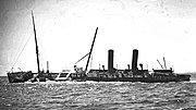 The wreck, c. 1910
 -
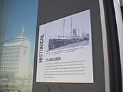 Fremantle Port information plaque


References[edit]
- ^ a b "Orizaba". Shipping And Shipbuilding. Shipping and Shipbuilding Research Trust. Retrieved 11 November 2021.
- ^ a b c d "SS Orizaba 1905". Archived from the original on 24 September 2015. Retrieved 7 May 2014.
- ^ "Marine Disaster". The West Australian. Perth, WA. 17 February 1905. p. 7. Retrieved 19 January 2016 – via Trove.
- ^ "RMS Orizaba plaque". Fremantle Port Authority. 7 May 2014. Retrieved 9 July 2020.
- ^ Wiegand, Auguste (1898), Orizaba gavotte, Rene Desjardins Conservatoire of Music, retrieved 28 September 2019
Further reading[edit]
- McCarthy, M. (1980). SS Orizaba, unpublished Wreck Inspection Report (Report). Department of Maritime Archaeology, Western Australian Maritime Museum.
- Wolfe, A. (1986). SS Orizaba, Graduate Diploma Course in Maritime Archaeology Report (Report). Department of Maritime Archaeology, Western Australian Maritime Museum.
External links[edit]
Wikimedia Commons has media related to Orizaba (ship, 1886).
32°16′43″S 115°37′30″E / 32.278613°S 115.624866°E
This article about a shipwreck is a stub. You can help Wikipedia by expanding it. |