Rakova (Čačak)
Appearance
Rakova | |
|---|---|
Village | |
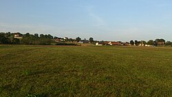
 View of fields and houses in the village of Rakova | |
| Country | |
| District | Moravica District |
| Municipality | Čačak |
| Area | |
| • Total | 9.39 km2 (3.63 sq mi) |
| Elevation | 311 m (1,020 ft) |
| Population (2011) | |
| • Total | 661 |
| • Density | 70/km2 (180/sq mi) |
| Time zone | UTC+1 (CET) |
| • Summer (DST) | UTC+2 (CEST) |
Rakova is a village in the municipality of Čačak, Serbia. According to the 2011 census, the village has a population of 661 people.[2] Rakova have river Čemernica, which Is full of beautiful nature. The name Rakova originated from the river Čemernica, because Čemernica had a lot of "rakova", or in English crayfish
References
[edit]- ^ "Насеља општине Чачак" (PDF). stat.gov.rs (in Serbian). Statistical Office of Serbia. Retrieved 12 October 2019.
- ^ Popis stanovništva, domaćinstava i Stanova 2002. Knjiga 1: Nacionalna ili etnička pripadnost po naseljima. Republika Srbija, Republički zavod za statistiku Beograd 2003. ISBN 86-84433-00-9
43°56′03″N 20°22′09″E / 43.93417°N 20.36917°E

