
Road signs in Bulgaria

Road signs in the Republic of Bulgaria were introduced by the Road Traffic Act and are regulated by:
- Regulations for the implementation of the Road Traffic Act, adopted by a Decree of the Council of Ministers;[1][2]
- Ordinance No. 18 of July 23, 2001 on road signaling with traffic signs, issued by the Minister of Regional Development and Public Works.[3]
Both normative documents are harmonized with the Vienna Convention on Road Signs and Signals (1968), which was ratified by Bulgaria on December 28, 1978 (This Convention was not published in the State Gazette).[4] Bulgaria made two declarations upon signature, one reservation upon ratification and one declaration upon ratification. One reservation made upon ratification is regarding transliteration into Latin characters solely to indicate the terminal points of international routes passing through Bulgaria and places of interest to international tourism. This is due to the fact that the Cyrillic script is used in the writing system of the Bulgarian language, the official language of Bulgaria.
Road signs in Bulgaria use the SNV typeface, which is also used in neighboring countries in the Balkans such as Romania, Serbia and North Macedonia. Inscriptions on road signs are usually written in both Bulgarian and English (Cyrillic and Latin scripts respectively), including settlement names.
Today there are some differences between the two documents regarding road signs. The latest changes in Ordinance No. 18 were promulgated in the State Gazette No. 13, dated February 14, 2020. These changes are not reflected in the Regulations for the Implementation of the Road Traffic Act.
Warning signs[edit]
-
 A1
A1
Right curve -
 A2
A2
Left curve -
 A3
A3
Double curve, first at right -
 A4
A4
Double curve, first at left -
 A5
A5
Steep downhill -
 A6
A6
Steep uphill -
 A7
A7
Road narrows — two-sided -
 A8
A8
Road narrows - on the right -
 A9
A9
Road narrows - on the left -
 A10
A10
Opening bridge -
 A11
A11
Unprotected quayside or riverbank -
 A12
A12
Uneven road -
 A13
A13
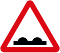
Speed bump -
 A14
A14
Dangerous roadside -
 A15
A15
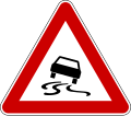
Slippery road -
 A16
A16
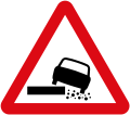
Loose chippings -
 A17
A17
Falling rocks -
 A18
A18
Pedestrian crossing -
 A19
A19
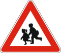
Children area -
 A20
A20
Cyclists -
 A21
A21
Domesticated animals -
 A22
A22
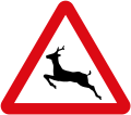
Wild animals -
 A23
A23
Roadworks -
 A24
A24
Traffic lights -
 A25
A25
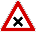
Crossroads without priority (give way to the vehicles coming from the right) -
 A26
A26
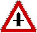
Intersection with a secondary road -
 A27
A27
Secondary road junction on the right -
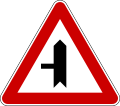 A28
A28
Secondary road junction on the left -
 A29
A29
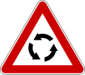
Roundabout ahead -
 A30
A30
Two - way traffic -
 A31
A31
Trams -
 A32
A32
Level crossing with barriers ahead -
 A33
A33
Level crossing without barriers ahead -
 A34.1
A34.1
Single track level crossing -
 A34.2
A34.2
Multitrack level crossing -
 A35.1
A35.1
Distance to the road-railway crossing -
 A35.2
A35.2
Distance to the road-railway crossing -
 A35.3
A35.3
Distance to the road-railway crossing -
 A36
A36
Low-flying aircraft -
 A37
A37
Crosswinds -
 A38
A38
Tunnel -
 A39
A39
Other hazards -
 A40
A40
Accident-prone road area -
 A41
A41
Traffic jam -
 A42
A42
Fog -
 A43
A43
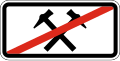
A traffic accident has occurred


Priority signs[edit]
-
 B1
B1
Give way -
 B2
B2
Stop -

-
 B4
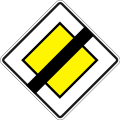
B4
End of priority road -
 B5
B5
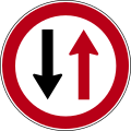
Give way to vehicles coming from the opposite direction -
 B6
B6
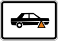
Priority over vehicles in opposite direction


Prohibitory signs[edit]
-
 V1
V1
No entry -
 V2
V2
Road closed to all traffic -
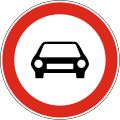 V3
V3
No motor vehicles -
 V4
V4
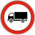
No trucks/heavy goods vehicles -
 V5
V5
No trucks/heavy goods vehicles pulling trailers -
 V6
V6
No trailers -
 V7
V7
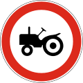
No tractors -
 V8
V8
No motorcycles -
 V9
V9
No bicycles -
 V10
V10
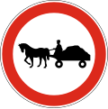
No horse-drawn vehicles -
 V11
V11
No handcarts -
 V12
V12
No pedestrians -
 V13
V13
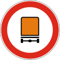
No vehicles carrying dangerous goods -
 V14
V14
No trucks and motorbikes -
 V15
V15
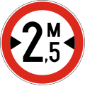
Width limit (2.5 metres) -
 V16
V16
Height limit (3.5 metres) -
 V17
V17
Length limit (12 metres) -
 V18
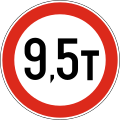
V18
Weight limit (9.5 tonnes) -
 V19
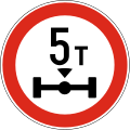
V19
Weight limit per axle -
 V20
V20
No traffic allowed without indicated minimum distance between vehicles -
 V21
V21
No right turn -
 V22
V22
No left turn -
 V23
V23
No U-turn -
 V24
V24
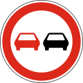
No overtaking -
 V25
V25
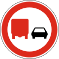
No overtaking by trucks/heavy goods vehicles -
 V26
V26
Speed limit (50 km/h) -
 V26
V26
Speed limit (60 km/h) -
 V26
V26
Speed limit (80 km/h) -
 V27
V27
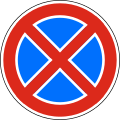
Do not block -
 V28
V28
No parking -
 V29
V29
Stop for customs -
 V30
V30
No sound signals -
 V31
V31
End of no overtaking zone -
 V32
V32
End of no overtaking by trucks/heavy goods vehicles zone -
 V33
V33
End of speed limit (50 km/h) -
 V34
V34
End of all restrictions


.svg)
.svg)
.svg)


.svg)

Mandatory signs[edit]
-
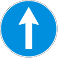 G1
G1
Keep straight -
 G2
G2
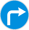
Turn right ahead -
 G3
G3
Turn left ahead -
 G4
G4
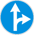
Turn right or go straight ahead -
 G5
G5
Turn left or go straight ahead -
 G6
G6
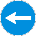
Turn left or right ahead -
 G7
G7
Turn right before the sign -
 G8
G8
Turn left before the sign -
 G9
G9
Keep right -
 G10
G10
Keep left -
 G11
G11
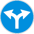
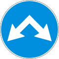
Keep left or right -
 G12
G12
Roundabout -
 G13
G13
Exclusive bus or trolleybus lane -
 G14
G14
Bicycle lane -
 G15
G15
Pedestrian lane -
 G16
G16
Segregated pedestrian and bicycle path -
 G17
G17
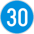
Minimum speed limit (30 km/h) -
 G17
G17
Minimum speed limit (50 km/h) -
 G18
G18
End of minimum speed limit (30 km/h) -
 G18
G18
End of minimum speed limit (50 km/h) -
 G19
G19
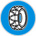
Snow chains compulsory -
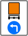 G20
G20
Vehicles carrying hazardous goods should turn left


.svg)
.svg)
.svg)
.svg)


Special regulations signs[edit]
-
 D1
D1
Number of lanes and traffic directions -
 D2
D2
Additional road lane for slow-moving road vehicles -
 D2
D2
Additional road lane for slow-moving road vehicles -
 D2
D2
Additional road lane for slow-moving road vehicles -
 D3
D3
Pre-compilation indicator -
 D4
D4
One-way traffic -
 D5
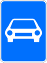
D5
Motorway -
 D6
D6
End of motorway -
 D7
D7
Limited-access highway (option 1) -
 D7
D7
Limited-access highway (option 2) -
 D8
D8
End of limited-access highway (option 1) -
 D8
D8
End of limited-access highway (option 2) -
 D9
D9
Entrance to tunnel (option 1) -
 D9
D9
Entrance to tunnel (option 2) -
 D10
D10
End of tunnel (option 1) -
 D10
D10
End of tunnel (option 2) -
 D11
D11
Entrance to built-up area -
 D12
D12
End of built-up area -
 D13
D13
No parking zone -
 D14
D14
End of no parking zone -
 D15
D15
Entrance to residential area zone -
 D16
D16
End of residential area zone -
 D17
D17
Pedestrian zone -
 D18
D18
Hospital -
 D19
D19
Parking -
 D20
D20
Paid parking -
 D21
D21
Disabled people parking -
 D22
D22
Bus stop -
 D23
D23
Trolleybus stop -
 D24
D24
Tram stop -
 D25
D25
Vignette road -
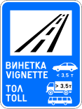 D25
D25
Vignette and toll road -
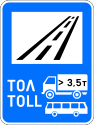 D25
D25
Toll road


.svg)


Indication signs[edit]
-
 Е1
Е1
Medical center -
 Е2
Е2
A hospital with an emergency department -
 Е3
Е3
Police -
 Е4
Е4
Telephone -
 Е7.1
Е7.1
Gas station -
 Е7.2
Е7.2
Gas station -
 Е7.3
Е7.3
Gas station that also offers unleaded gasoline -
 Е19
Е19
Toilet -
 Е20
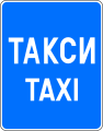
Е20
Taxi stand -
 Е21
Е21
Pedestrian onderpass -
 Е22
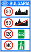
Е22
National speed limits (used at border crossings with other countries) -
 Е24
Е24
Control with automated technical means or systems -
 Е25
Е25
Charging station for electric vehicles


Information signs[edit]
-
 Z1
Z1
Preliminary route guide sign -
 Z2
Z2
Route guide sign with destinations used on highways -
 Z2
Z2
Route guide sign with destinations used on roads -
 Z2
Z2
Route guide sign with destinations used inside cities -
 Z9
Z9
U-turn permitted -
 Z10
Z10
Destinations sign with distances used on highways -
 Z10
Z10
Destinations sign with distances used on roads -
 Z12
Z12
Entry to no through road -
 Z13
Z13
Dead end -
 Z18
Z18
Emergency escape lane for runaway vehicles -
 Z19
Z19
50 km/h advisory speed -
 Z20/Z21
Highway route number sign


Additional plates[edit]
-
 Т1
Т1
Above sign effective in 1300 metres -
 Т2
Т2
Sign area effective -
 Т3
Т3
Plate indicating beginning of stopping or parking prohibition -
 Т8
Т8
Stop ahead in 50 metres (placed below the give way sign to warn of a stop sign ahead) -
 Т13
Т13
Diagram of priority road direction -
 T14.2
T14.2
Road conditions (rainfall) -
 T15
T15
Working days -
 T16
T16
Saturdays, Sundays and holidays -
 T17
T17
Text plate -
 T18.1
T18.1
Plate indicating that unattended vehicle will be towed-away at the expense of the vehicle owner -
 T18.2
T18.2
Placement of restrictive measures


References[edit]
- ^ "Правилник за прилагане на Закона за движението по пътищата (на сайта на МВР)" (PDF).
- ^ Правилник за прилагане на закона за движението по пътищата. Effective from June 1, 1996. Last amended and add. DV. no. 13 of February 17, 2015, lex.bg
- ^ "Наредба №18 от 23.07.2001 г. за сигнализация на пътищата с пътни знаци (на сайта на МРРБ)" (PDF).
- ^ "United Nations Treaty Collection". treaties.un.org. Retrieved 2023-11-28.
External links[edit]
 Media related to Road signs in Bulgaria at Wikimedia Commons