Rotokawa Power Station
Appearance
| Rotokawa Power Station | |
|---|---|
 | |
| Country | New Zealand |
| Location | Waikato |
| Coordinates | 38°36′43″S 176°11′35″E / 38.61194°S 176.19306°E |
| Status | Operational |
| Commission date | 1997, 2002 |
| Owner(s) | Mercury Energy |
| Power generation | |
| Nameplate capacity | 34 MW |
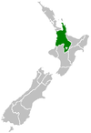
The Rotokawa Power Station is a geothermal power station owned and operated by Mercury Energy. It is located approximately 10 km north east of Taupō in New Zealand. The station uses a binary cycle manufactured by Ormat Industries.

In May 2008, work began on the nearby Nga Awa Purua Power Station.[1]
Environmental aspects
[edit]Due to the high temperatures associated with the geothermal vent here, this locale is an occurrence of extremophile micro-organisms that can thrive on the high vent water temperature.[2]
See also
[edit]References
[edit]- ^ "Rotokawa". Mighty River Power. Archived from the original on 8 November 2008.
- ^ C.Michael Hogan. 2010. Extremophile. eds. E.Monosson and C.Cleveland. Encyclopedia of Earth. National Council for Science and the Environment, Washington DC

