Rue de la Ferronnerie
Appearance
 | |
| Length | 114 m (374 ft) |
|---|---|
| Width | 16.6 m (54 ft) |
| Arrondissement | 1st |
| Quarter | Les Halles |
| Coordinates | 48°51′37″N 2°20′52″E / 48.860238°N 2.347747°E |
| Construction | |
| Completion | Before 1229 |
| Denomination | 1229 |
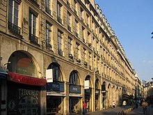
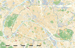
The Rue de la Ferronnerie is a street in the 1st arrondissement of Paris, in the Les Halles area.
History[edit]
Before 1229 the name of the street was rue de la Charronnerie (ou des Charrons). The street had its current name in 1229.

Henry IV of France was assassinated by Ravaillac on May 14, 1610[1] A marking on the street at no. 11 shows where the event took place.
One of the longest buildings in Paris is located on 2-4-6-8-10-12-14 rue de la Ferronnerie.[2] The building was constructed between 1669 and 1678.
References[edit]
- ^ "Movie about King Henry IV killed rue de la Ferronnerie in 1610". Archived from the original on April 8, 2016. Retrieved November 30, 2016.
- ^ Pictures from renovation of 12 rue de la Ferronnerie Archived July 18, 2011, at the Wayback Machine
External links[edit]
- Nomenclature officielle des voies de Paris Archived January 7, 2013, at archive.today
- Thierry Issartel, "Henri IV, les clés d'un règne", Gascogne Editing (Orthez), 2010.

