Rukai Lake
Appearance
| Rukai | |
|---|---|
 Rukai Lake from the eastern coast | |
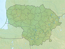
| Location | Kėdainiai District Municipality, Lithuania |
| Coordinates | 55°27′51″N 23°44′28″E / 55.46417°N 23.74111°E |
| Part of | Dotnuvėlė→Nevėžis→Neman→Baltic Sea |
| Max. length | 0.7 km (0.43 mi) |
| Max. width | 0.1 km (0.062 mi) |
| Surface area | 0.064 km2 (0.025 sq mi)[1] |
| Shore length1 | 1.5 km (0.93 mi) |
| Surface elevation | 92.9 m (305 ft) |
| Settlements | Rukai |
| 1 Shore length is not a well-defined measure. | |
The Rukai is a lake in Krakės Eldership, Kėdainiai District Municipality, central Lithuania. It is located 7 kilometres (4.3 mi) to the north from Krakės town, at Rukai village. It belongs to the Dotnuvėlė basin (part of the Nevėžis basin).
Coasts of the lake are flat, swampy, covered by reed beds.
The name Rukai comes from the village name Rukai.[2]
References
[edit]Wikimedia Commons has media related to Rukai (lake).
- ^ "Rukai (ežeras)". Gamtos katalogas. Retrieved 2020-12-14.
- ^ Vanagas, Aleksandras (1981). Lietuvių hidronimų etimologinis žodynas (in Lithuanian). Vilnius: Mokslas.


