
Saha (crater)
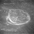
 Lunar Orbiter 2 image | |
| Coordinates | 1°36′S 102°42′E / 1.6°S 102.7°E |
|---|---|
| Diameter | 99 km |
| Depth | Unknown |
| Colongitude | 258° at sunrise |
| Eponym | Meghnad Saha |


Saha is a lunar impact crater on the Moon's far side, behind the eastern limb as seen from the Earth. It lies less than one crater diameter due east of the similar-sized Wyld, and to the north-northwest of the large walled plain Pasteur.
This crater has been worn and damaged by subsequent impacts, including the satellite crater Saha W which lies across the northwest rim and inner wall. The inner sides still display some terrace-like shelf structures, but these have become worn and have lost definition. There is a small, bowl-shaped crater Saha M in the southwestern part of the interior floor. To the north of this feature is an arcing ridge feature. The floor is otherwise pitted by various tiny craterlets. This crater is a proposed site of Lunar Crater Radio Telescope along with Daedalus crater.[1]
Satellite craters
[edit]By convention these features are identified on lunar maps by placing the letter on the side of the crater midpoint that is closest to Saha.
| Saha | Latitude | Longitude | Diameter |
|---|---|---|---|
| B | 1.5° N | 104.5° E | 34 km |
| C | 1.4° N | 107.8° E | 64 km |
| D | 0.1° N | 107.5° E | 35 km |
| E | 0.2° S | 107.6° E | 28 km |
| J | 4.0° S | 105.3° E | 52 km |
| M | 2.2° S | 102.6° E | 18 km |
| N | 4.1° S | 101.5° E | 49 km |
| W | 0.6° S | 101.4° E | 34 km |
-
 Saha E crater from Apollo 11

References
[edit]- ^ Stenger, Richard (9 January 2002). "Astronomers push for observatory on the moon". CNN. Archived from the original on 25 March 2007. Retrieved 26 January 2007.
- Andersson, L. E.; Whitaker, E. A. (1982). NASA Catalogue of Lunar Nomenclature. NASA RP-1097.
- Blue, Jennifer (July 25, 2007). "Gazetteer of Planetary Nomenclature". USGS. Retrieved 2007-08-05.
- Bussey, B.; Spudis, P. (2004). The Clementine Atlas of the Moon. New York: Cambridge University Press. ISBN 978-0-521-81528-4.
- Cocks, Elijah E.; Cocks, Josiah C. (1995). Who's Who on the Moon: A Biographical Dictionary of Lunar Nomenclature. Tudor Publishers. ISBN 978-0-936389-27-1.
- McDowell, Jonathan (July 15, 2007). "Lunar Nomenclature". Jonathan's Space Report. Retrieved 2007-10-24.
- Menzel, D. H.; Minnaert, M.; Levin, B.; Dollfus, A.; Bell, B. (1971). "Report on Lunar Nomenclature by the Working Group of Commission 17 of the IAU". Space Science Reviews. 12 (2): 136–186. Bibcode:1971SSRv...12..136M. doi:10.1007/BF00171763. S2CID 122125855.
- Moore, Patrick (2001). On the Moon. Sterling Publishing Co. ISBN 978-0-304-35469-6.
- Price, Fred W. (1988). The Moon Observer's Handbook. Cambridge University Press. ISBN 978-0-521-33500-3.
- Rükl, Antonín (1990). Atlas of the Moon. Kalmbach Books. ISBN 978-0-913135-17-4.
- Webb, Rev. T. W. (1962). Celestial Objects for Common Telescopes (6th revised ed.). Dover. ISBN 978-0-486-20917-3.
- Whitaker, Ewen A. (1999). Mapping and Naming the Moon. Cambridge University Press. ISBN 978-0-521-62248-6.
- Wlasuk, Peter T. (2000). Observing the Moon. Springer. ISBN 978-1-85233-193-1.