
Sangla, India
This article needs additional citations for verification. (June 2011) |
This article is written like a manual or guide. (March 2020) |
Sangla is a town in the Baspa Valley, also referred to as the Sangla valley, in the Kinnaur District of Himachal Pradesh, India, close to the Tibetan border.
Geography
[edit]Sangla Valley or the Baspa Valley starts at Karcham and ends at Chitkul.
Demographics
[edit]The local people have a distinct culture and their own dialect, the Kinnauri language.[citation needed] 31°25′29″N 78°15′58″E / 31.4248°N 78.2661°E
Places of Interest
[edit]Being located at center of the Baspa valley, Sangla is the locus of exploration and trekking trails. [citation needed]
Kamru Fort
Lake and Dam, Kupa
Temples
- Badrinath Temple, Kamru
- Bering Nag Temple, Sangla
- Batseri
- Mata Devi Temple Chhitkul
- Piri Nages Temple, Sapni[1]
Trek Routes
- Rupin Valley Trek[2]
- Sangla Kande Trek
- Charang Chitkul Trek
Apart from these places, the tourists can walk to the Trout Farm, The Mall(Sangla), Riverside in Chitkul and village walks in Kupa, Kamru, Sangla and Batseri.[3]
Festivals
[edit]- Saazo - January
- Faagul/ Holi - March
- Dakhrain - July[4]
- Ukhyang - September
Gallery
[edit]-
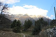 Sangla valley
 -
 Sangla valley hill top


References
[edit]- ^ "Sapni Fort". Kinnaur.
- ^ "Unexplored Trek Routes". Viral Khichdi.
- ^ "Sangla – A Buddhist Town in the lap of Himalayas!". Raacho Trekkers.
- ^ "Festival Of Flowers". Kinnaur Tourism.
External links
[edit]
This Himachal Pradesh location article is a stub. You can help Wikipedia by expanding it. |