
Sde Nahum
Sde Nahum
שְׂדֵה נַחוּם | |
|---|---|
 | |
| Etymology: Nahum’s Field | |
 Sde Nahum  Sde Nahum | |
| Coordinates: 32°31′31″N 35°28′54″E / 32.52528°N 35.48167°E | |
| Country | |
| District | Northern |
| Council | Valley of Springs |
| Affiliation | Kibbutz Movement |
| Founded | 5 January 1937 |
| Founded by | Sadeh group members |
| Population (2022)[1] | 1,078 |
| Website | www.sde-nahum.org.il |
Sde Nahum (Hebrew: שְׂדֵה נַחוּם, lit. Nahum Field) is a kibbutz in the Beit She'an Valley in northern Israel. Located around 4 km northwest of Beit She'an, it falls under the jurisdiction of Valley of Springs Regional Council. In 2022 it had a population of 1,078.[1]
History
[edit]The nearby Palestinian village of Saffuriya had been almost emptied of its 4000 inhabitants in July 1948. By early January, 1949, about 500 villagers had filtered back, but "neighbouring settlements coveted Saffuriya lands". The "Northern Front" ordered their eviction, which was carried out the 7th of January 1949. The Saffuriya land was then distributed to its neighbouring Jewish settlements.[2]
In February 1949, 1,500 Dunams of Saffuriya land was given to Sde Nahum.[2]
-
 Sde Nahum day of the Aliyah 1937
 -
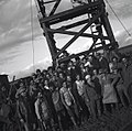 Sde Nahum founders 1937
 -
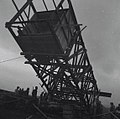
 Sde Nahum construction of stockade wall 1937
 -
 Sde Nahum wall construction 1937
 -
 Sde Nahum 1937
 -
 Sde Nahum 1939
 -
 Sde Nahum 1939
 -
 Sde Nahum 1940
 -
 1947 photo of Nahum classroom from Palmach archive


Notable people
[edit]- Arieh Warshel, Nobel Prize-winning chemist (2013) and professor at the University of Southern California was born in Sde Nahum in 1940[3]
References
[edit]- ^ a b "Regional Statistics". Israel Central Bureau of Statistics. Retrieved 21 March 2024.
- ^ a b Morris, B. (2004). The Birth of the Palestinian Refugee Problem Revisited. Cambridge University Press. pp. 516, 517. ISBN 978-0-521-00967-6.
- ^ Gregersen, Erik (November 16, 2018). "Arieh Warshel". Encyclopædia Britannica. Encyclopædia Britannica, Inc. Retrieved April 23, 2019.
External links
[edit]Categories:
- Valley of Springs Regional Council
- Kibbutzim
- Kibbutz Movement
- Populated places established in 1937
- Archaeological sites in Israel
- Populated places in Northern District (Israel)
- 1937 establishments in Mandatory Palestine
- Austrian-Jewish culture in Israel
- German-Jewish culture in Israel
- Polish-Jewish culture in Israel