Sea Park, South Africa
Appearance
Sea Park | |
|---|---|
| Coordinates: 30°41′53″S 30°29′24″E / 30.698°S 30.49°E | |
| Country | South Africa |
| Province | KwaZulu-Natal |
| District | Ugu |
| Municipality | Ray Nkonyeni |
| Main Place | Port Shepstone |
| Area | |
| • Total | 3.28 km2 (1.27 sq mi) |
| Population (2011)[1] | |
| • Total | 2,027 |
| • Density | 620/km2 (1,600/sq mi) |
| Racial makeup (2011) | |
| • Black African | 31.6% |
| • Coloured | 3.3% |
| • Indian/Asian | 9.1% |
| • White | 55.5% |
| • Other | 0.5% |
| First languages (2011) | |
| • English | 46.0% |
| • Afrikaans | 27.0% |
| • Zulu | 19.7% |
| • Xhosa | 5.3% |
| • Other | 2.0% |
| Time zone | UTC+2 (SAST) |
| PO box | 4241 |
| Area code | 039 |
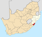
Sea Park is a coastal village situated along the South Coast of KwaZulu-Natal, South Africa. It forms part of the greater area of Port Shepstone in the Ray Nkonyeni Local Municipality.
Location
[edit]Sea Park is situated on the coastal R102 route connecting Melville (6 km) to the north with Port Shepstone (5 km) to the south. The village is bounded by the Mhlangamkhulu River to the north, beyond which lies Southport and the Mtentweni River to the south, beyond which lies Umtentweni.[2]
References
[edit]- ^ a b c d "Sub Place Sea Park". Census 2011.
- ^ "Sea Park". www.sa-venues.com. Retrieved 2024-08-18.


