
Skuta Glacier
| Skuta Glacier | |
|---|---|
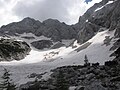
 Skuta Glacier and its snow fields in summer of 2014. | |
 Skuta Glacier Location in Slovenia  Skuta Glacier Skuta Glacier (Alps) | |
| Type | Mountain glacier |
| Location | mountain Skuta in Kamnik-Savinja Alps in Slovenia |
| Coordinates | 46°21′54.97″N 14°33′36.36″E / 46.3652694°N 14.5601000°E |
| Area | 1.7 ha (4.2 acres) |
| Status | Retreating |
 | |
Skuta Glacier (Slovenian: Ledenik pod Skuto), located beneath mountain Skuta in Kamnik-Savinja Alps in Slovenia is the most south-eastern glacier in the Alps.
Geography
[edit]Skuta Glacier had an area of 2.8 hectares (6.9 acres) in 1950 and 1.7 hectares (4.2 acres) in 2013.[1] Reaching 2,020 metres (6,630 ft) above sea level at its lowest point, it is also one of the lowest elevation glaciers in the Alps.[2]
Triglav glacieret is the second remaining glacier in Slovenia at the elevation of 2500 m.
Skuta Glacier in figures
[edit]- Area: 1.7 hectares (4.2 acres) (as of 2007)[1]
- Elevation: 2,020–2,120 m (6,630–6,960 ft)[1]
- Average ice thickness: 7 m (23 ft) (as of September 2006)[1]
- Maximum ice thickness: 12 m (39 ft) (as of September 2006)[1]
- Volume: 80,000 m3 (2,800,000 cu ft) (as of September 2006)[1]
-
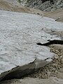
 Snow fields beneath the glacier
 -
 Snow fields around the Skuta Glacier
 -
 Snow fields beneath the Skuta Glacier
 -
 The glacier gives birth to the small stream
 -
 Glacier snow
 -
 Chamois passing the glacier


References
[edit]- ^ a b c d e f "Domov | ZRC SAZU". giam.zrc-sazu.si. Archived from the original on 2014-01-11.
- ^ "Triglavski ledenik izginja počasneje od napovedi". October 2013.
This article about a glacier is a stub. You can help Wikipedia by expanding it. |