
Stóra Dímun
You can help expand this article with text translated from the corresponding article in Danish. (January 2022) Click [show] for important translation instructions.
|
Stóra Dímun | |
|---|---|
 Map of Stóra Dímun | |
 Location within the Faroe Islands | |
| Coordinates: 61°41′N 6°44′W / 61.683°N 6.733°W | |
| State | |
| Constituent country | |
| Area | |
| • Total | 2.5 km2 (1.0 sq mi) |
| Highest elevation | 396 m (1,299 ft) |
| Population (1 January 2018) | |
| • Total | 10 |
| • Density | 4.0/km2 (10/sq mi) |
| (5 Adults, 5 children) | |
| Time zone | UTC+0 (GMT) |
| • Summer (DST) | UTC+1 (EST) |
| Postal code | FO 286 |
| Calling code | 298 |
Stóra Dímun (Danish: Stor Dímun) is an island in the southern Faroe Islands, sometimes only referred to as Dímun. It is accessible by sea only during periods of clear and calm weather, but there is a regular helicopter service twice a week all year. There is a lighthouse on the island.
Etymology[edit]
The name 'Stóra Dímun' means 'Great Dimun', in contrast to 'Lítla Dímun' or 'Little Dimun'. According to the Faroese placename expert Jakobsen, 'Dimun' may represent a pre-Norse, Celtic placename element, with 'di' representing 'two'. [1] Stora and Litla Dímun shows a pairing of two distinctive but separate localities in one name. Gammeltoft concluded Dímun is a Scandinavian place name for a double-peaked feature of a particular appearance, reflecting a linguistic contact between Scandinavians and Gaels.[2]
Population[edit]
Before 1920, the ruins of an old church were present, but these no longer exist. There are two peaks on Stóra Dímun: Høgoyggj (396 metres; 1300') and Klettarnir (308 metres; 1010'). The island was once home to many families from the 13th century onwards, but now only two families of seven make their home on the island.[3]
The Farm[edit]
There is only one farm at the Southside of the island, and it constitutes its only settlement. The farm benefits from soil that has been fertilized by the guano of millions of seabirds for thousands of years. This gives excellent grazing for the 450 ewes that the island supports. The farm is famed for their turnips and sheepskin, of which they produce some 300-400 each year.[4]
Six to eight calves are slaughtered every year.
There is some tourism during the summer months.
Important bird area[edit]
The island has been identified as an Important Bird Area by BirdLife International because of its significance as a breeding site for seabirds, especially European storm petrels (15,000 pairs), Atlantic puffins (40,000 pairs) and black guillemots (50 pairs).[5]
See also[edit]
Gallery[edit]
-
 Aerial view of Stóra Dímun
Stamp FO 475 of Postverk Føroya
Issued: 16 Jan 2004 -

-
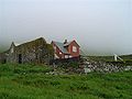 The farm on the island of Stóra Dímun
 -
 Puffins (Fratercula arctica) on Stóra Dímun


References[edit]
- ^ Fridtjof Nansen (17 April 2014). In Northern Mists. Cambridge University Press. p. 163. ISBN 9781108071703. Retrieved 23 July 2014.
- ^ Gammeltoft 2004, p. 33.
- ^ "Stóra Dímun - One of most exotic places in the world". storadimun.fo. Retrieved 2018-03-19.
- ^ "Dímunargarður".
- ^ BirdLife International. (2012). Important Bird Areas factsheet: Stóra Dímun. Downloaded from http://www.birdlife.org on 2012-02-24.
Secondary sources[edit]
Gammeltoft, Peder (2004), "Among Dimons and Papeys: What kind of contact do the names really point to?" (PDF), Northern Studies, 38: 31–50
External links[edit]
 Media related to Stóra Dímun at Wikimedia Commons
- Personal website with aerial photos