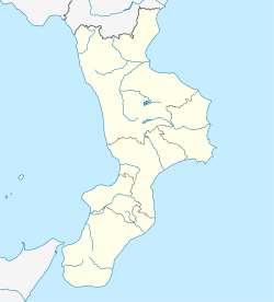
Stalettì
Appearance
Stalettì | |
|---|---|
| Comune di Stalettì | |
| Coordinates: 38°45′55″N 16°32′20″E / 38.76528°N 16.53889°E | |
| Country | Italy |
| Region | Calabria |
| Province | Catanzaro (CZ) |
| Frazioni | Santa Maria del Mare, Torrazzo, Copanello, Caminia, Pietragrande |
| Area | |
| • Total | 11 km2 (4 sq mi) |
| Elevation | 382 m (1,253 ft) |
| Population (31 December 2013)[2] | |
| • Total | 2,486 |
| • Density | 230/km2 (590/sq mi) |
| Demonym | Stalettesi |
| Time zone | UTC+1 (CET) |
| • Summer (DST) | UTC+2 (CEST) |
| Postal code | 88069 |
| Dialing code | 0961 |
| Patron saint | San Gregorio |
| Saint day | 17 November |
| Website | Official website |
Stalettì is a town and comune in the province of Catanzaro in the Calabria region of southern Italy.
Geography
[edit]The town is bordered by Montauro and Squillace. It has a very well-rounded landscape, including beautiful beaches in the Caminia, Copanello, and Pietragrande frazioni, as well as hills and mountains.
There are many farms, as well, with the predominant export being olives and olive oil.
There is limited road access connecting the upper and lower sections of Stalettì, and it has rendered difficult particularly in moments of need, such as fires and other emergencies.
Notes and references
[edit]This article needs additional citations for verification. (May 2016) |
Guida storico-turistica di Stalettì by Rosario Casalenuovo (Archeoclub d'Italia, Rome 1996)
External links
[edit]- The fountain of Cassiodorus. With the nearby Casino Pepe, one of the best-hidden historical treasures of Stalettì.
- La fontana di Cassiodoro. Versione italiana di "The Fountain of Cassiodorus".
- ^ "Superficie di Comuni Province e Regioni italiane al 9 ottobre 2011". Italian National Institute of Statistics. Retrieved 16 March 2019.
- ^ "Popolazione Residente al 1° Gennaio 2018". Italian National Institute of Statistics. Retrieved 16 March 2019.


