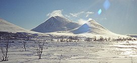
Storsølnkletten
Appearance
| Storsølnkletten | |
|---|---|
 Storsølnkletten (left) seen from the north | |
| Highest point | |
| Elevation | 1,827 m (5,994 ft)[1] |
| Prominence | 1,047 m (3,435 ft)[1][2] |
| Isolation | 19.3 km (12.0 mi)[1] |
| Coordinates | 61°58′48″N 10°17′34″E / 61.980028°N 10.292787°E |
| Geography | |
| Location | Innlandet, Norway |
| Topo map(s) | 1519 II Folldal and 1818 IV Atnsjøen |
| Climbing | |
| Easiest route | Easy scrambling |
Storsølnkletten (or Store Sølnkletten, Sølnkletten) is a prominent mountain in Alvdal Municipality in Innlandet county, Norway. The 1,827-metre (5,994 ft) tall mountain lies about 20 kilometres (12 mi) southwest of the village of Alvdal.[1][3]

The mountain is easily recognizable due to its saddle form with two peaks. The higher summit (to the southeast) reaches an elevation of 1,827 metres (5,994 ft) and the lower summit (to the northwest) has an elevation of 1,690 metres (5,540 ft). The lower summit is known as Spisskletten or Storsølnkletten lille.[1]
See also
[edit]References
[edit]- ^ a b c d e "Storsølnkletten". PeakVisor.no. Retrieved 14 February 2022.
- ^ "Storsølnkletten 1827 moh". Toppomania.
- ^ Thorsnæs, Geir, ed. (24 January 2022). "Sølnkletten". Store norske leksikon (in Norwegian). Kunnskapsforlaget. Retrieved 14 February 2022.


