
Suizen-ji Jōju-en
| Suizen-ji Jōju-en | |
|---|---|
| 水前寺成趣園 | |
 Suizen-ji Jōju-en
 | |
 | |
| Type | Japanese garden |
| Location | Kumamoto Prefecture, Japan |
| Coordinates | 32°47′28″N 130°44′05″E / 32.791092°N 130.734594°E |
| Created | 1636 |
Suizen-ji Jōju-en (水前寺成趣園) is a tsukiyama[note 1] Japanese garden located within Suizen-ji Park (水前寺公園, Suizen-ji Kōen) in Kumamoto Prefecture, Japan. The main tsukiyama is a representation of Mount Fuji. Lord Hosokawa Tadatoshi began construction of the garden in 1636 as a tea retreat. The park was named after a no-longer-extant Buddhist temple called Suizen-ji, and now hosts the Izumi Shrine, where members of the Hosokawa family are enshrined, and a Nōgaku-dō, a Noh theater. Lord Hosokawa selected this site because of its spring-fed pond, the clean water of which was excellent for tea.[1] The thatched Kokin-Denju-no-Ma teahouse was originally in Kyoto's Imperial Palace, but was moved here in 1912.
The garden has been declared by the national government a historic site of scenic beauty.
Suizenji Park[edit]
Suizenji Kōen is an interesting and popular venue, featuring miniature landscapes, a temple, and small lakes containing large koi. It is a short tram ride from the city. Nearby, there are many souvenir and snack shops.
Gallery[edit]
-
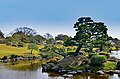
 The pond
 -
 The pond
 -
 The Kokin-Denju-no-Ma teahouse
 -
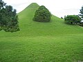
 Replica of Mount Fuji
 -
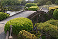 An arched bridge
 -
 Replica of Mount Fuji
 -
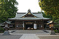 Izumi Shrine
 -
 A large carp in the park
 -
 Statue of Hosokawa Tadatoshi
 -
 Japanese pine on a miniature island
 -
 in Spring time


See also[edit]
Notes[edit]
- ^ Tsukiyama gardens are Japanese gardens featuring an artificial mountain (a tsukiyama).
References[edit]
- Explore Japan, Suizenji Garden accessed on August 31, 2009
- Mansfield, Stephen (2011). Japan's Master Gardens - Lessons in Space and Environment (Hardback). Tokyo, Rutland, Singapore: Tuttle. ISBN 978-4-8053-1128-8.
- ^ "Pylant, Don D. Japanese Gardening Organization - Suizenji Park". Botanysaurus. 11 October 2001. Archived from the original on 3 September 2010. Retrieved 23 July 2008.
This Japan-related article is a stub. You can help Wikipedia by expanding it. |