Surmo
Appearance
This article needs additional citations for verification. (October 2022) |
Surmo سرمو | |
|---|---|
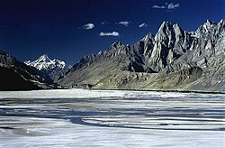
 The 7,821 m (25,659 ft) tall Masherbrum as viewed from Surmo | |
| Coordinates: 35°9′6.5181″N 76°26′43.6057″E / 35.151810583°N 76.445446028°E | |
| Country | Pakistan |
| Province | Gilgit Baltistan |
| District | Ghangche |
| Elevation | 8,532.504 ft (2,600.707 m) |
| Population | |
| • Total | 10,000 |
| Time zone | UTC+5 (PST) |
| • Summer (DST) | UTC+6 (GMT+6) |
Surmo Valley (Urduوادی سرمو) is a valley in the Ghangche District in Gilgit–Baltistan, Pakistan. Etymologically, the name is derived from sermo: ser means gold and mo feminises the word.
Location
[edit]

Surmo is approximately 12 kilometres (7.5 mi) from the district administrative capital of Khaplu. Its neighborhoods are Choghogrong, Tarkari, Khar, Gond, Langkhung, Tishari, and Ghazi-Thang. It is adjacent to the Shiok River.
History
[edit]Surmo is one of the oldest valleys in Baltistan and contains 150-year-old walnut trees. In 1996, stupas were found here. Local people call this place Rgyalmo Khar (a queen's palace) as it had been a rich village.[1]
References
[edit]- ^ "Geography and Brief History Chapter-II Page-33" (PDF). Archived from the original (PDF) on 11 October 2017.

