
Třebeň
Třebeň | |
|---|---|
 Eastern part of Třebeň | |
 Flag  Coat of arms | |
 Třebeň Location in the Czech Republic | |
| Coordinates: 50°7′44″N 12°24′0″E / 50.12889°N 12.40000°E | |
| Country | |
| Region | Karlovy Vary |
| District | Cheb |
| First mentioned | 1208 |
| Area | |
| • Total | 21.70 km2 (8.38 sq mi) |
| Elevation | 439 m (1,440 ft) |
| Population (2024-01-01)[1] | |
| • Total | 459 |
| • Density | 21/km2 (55/sq mi) |
| Time zone | UTC+1 (CET) |
| • Summer (DST) | UTC+2 (CEST) |
| Postal codes | 350 02, 351 34 |
| Website | www |
Třebeň (German: Trebendorf) is a municipality and village in Cheb District in the Karlovy Vary Region of the Czech Republic. It has about 500 inhabitants.
Administrative parts
[edit]The villages and hamlets of Chocovice, Doubí, Dvorek, Horní Ves, Lesina, Lesinka, Nový Drahov, Povodí and Vokov are administrative parts of Třebeň.
History
[edit]The first written mention of Třebeň is from 1208.[2]
Demographics
[edit]| Year | Pop. | ±% |
|---|---|---|
| 1869 | 1,321 | — |
| 1880 | 1,533 | +16.0% |
| 1890 | 1,377 | −10.2% |
| 1900 | 1,274 | −7.5% |
| 1910 | 1,326 | +4.1% |
| 1921 | 1,285 | −3.1% |
| 1930 | 1,455 | +13.2% |
| 1950 | 513 | −64.7% |
| 1961 | 453 | −11.7% |
| 1970 | 376 | −17.0% |
| 1980 | 391 | +4.0% |
| 1991 | 321 | −17.9% |
| 2001 | 347 | +8.1% |
| 2011 | 388 | +11.8% |
| 2021 | 449 | +15.7% |
| Source: Censuses[3][4] | ||
Gallery
[edit]-
 Church of Saint Lawrence
 -
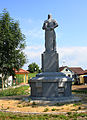 World War I memorial
 -
 Horní Ves, a part of Třebeň


.jpg)
References
[edit]- ^ "Population of Municipalities – 1 January 2024". Czech Statistical Office. 2024-05-17.
- ^ "O obci" (in Czech). Obec Třebeň. Retrieved 2022-04-20.
- ^ "Historický lexikon obcí České republiky 1869–2011 – Okres Cheb" (in Czech). Czech Statistical Office. 2015-12-21. pp. 15–16.
- ^ "Population Census 2021: Population by sex". Public Database. Czech Statistical Office. 2021-03-27.
External links
[edit]Wikimedia Commons has media related to Třebeň.
| Authority control databases: National |
|---|
This Karlovy Vary Region location article is a stub. You can help Wikipedia by expanding it. |