
Talk:Control of cities during the Syrian civil war/Archive 50
| This is an archive of past discussions. Do not edit the contents of this page. If you wish to start a new discussion or revive an old one, please do so on the current talk page. |
| Archive 45 | ← | Archive 48 | Archive 49 | Archive 50 | Archive 51 | Archive 52 | → | Archive 55 |
Advances south of Tal Abyad
Ali Bajliya and Brigade 93 have reportedly been liberated. However, I can't find any original source for everyone else's claims aside from Liwa Thuwwar al Raqqa. Given the wild claims made by LTR before, especially regarding the fall of Ayn Issa and the capture of Tel Seman, Khunayza and Hazima, I request that nobody changes anything from black until it gets confirmed by SOHR or other reputable sources. NightShadeAEB (talk) 15:23, 22 June 2015 (UTC) SOHR confirmed that they captured huge parts of it.Alhanuty (talk) 16:58, 22 June 2015 (UTC)
- Brigade 93 is already taken by YPG/Burkan. There are reports about the town of Ayn Issa (Bozanî) being captured by YPG/Burkan, but I suggest to wait untill ANHA confirms. Roboskiye (talk) 20:29, 22 June 2015 (UTC)
Sarrin
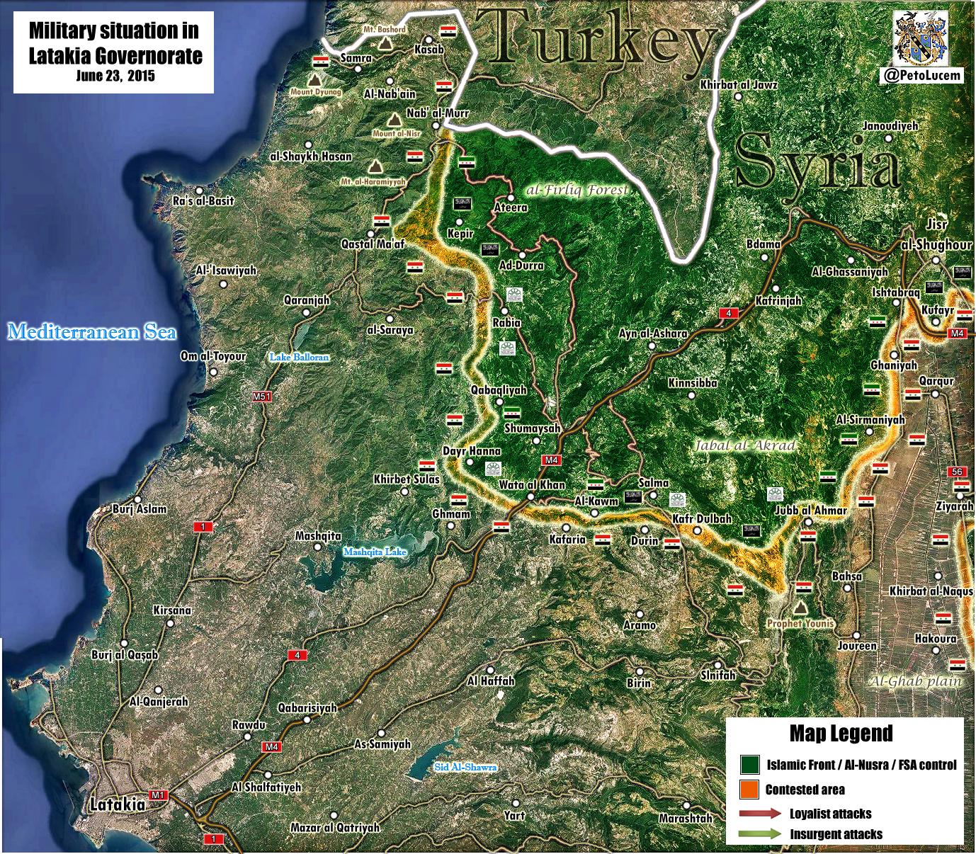
Pro-YPG sources claiming there has been a renewed offensive towards Sarrin from a Kurdish offensive in the north and an FSA offensive in the east. The map also shows Mistras to be under YPG control. Are there any neutral sources to back this up?
http://imgur.com/UYw7Gpn — Preceding unsigned comment added by Prohibited Area (talk • contribs) 11:27, 23 June 2015 (UTC)
Brigade 93
To the user that made the edit from green to contested, do NOT use English SOHR reports as there have been issues with those reports, like wrong info (yes, I have seen the debate here: https://en.wikipedia.org/wiki/Talk:Cities_and_towns_during_the_Syrian_Civil_War/Archive_46#Dear_editors.21.21.21) . I ain't going to revert out of fear of the one revert policy and get myself in trouble for it.
Only Arab SOHR reports allowed. Besides, the base IS retaken by the YPG-Rebels per: http://www.syriahr.com/2015/06/%D8%A7%D9%84%D9%88%D8%AD%D8%AF%D8%A7%D8%AA-%D8%A7%D9%84%D9%83%D8%B1%D8%AF%D9%8A%D8%A9-%D9%88%D8%A7%D9%84%D9%81%D8%B5%D8%A7%D8%A6%D9%84-%D8%A7%D9%84%D9%85%D9%82%D8%A7%D8%AA%D9%84%D8%A9-%D8%AA%D8%AF/.
To back it up (via news, that is neutral):
http://www.reuters.com/article/2015/06/22/us-mideast-crisis-syria-kurds-idUSKBN0P21HV20150622
Regards.--Damirgraffiti |☺What's Up?☺ 22:32, 22 June 2015 (UTC)
According to this Al Jazeera reporter, 93.brigade is captured and the town is contested. Some users find him pro-rebel but he states on his twitter wall that he follows the rebel uprising but not supporting anyone. Maybe the same as Eliah Magnier. I find him useful, maybe we can list him as an reliable source ? 100% of his reports are at the end confirmed as true DuckZz (talk) 23:59, 22 June 2015 (UTC)
- Additional reliable source also explains the same: http://www.telegraph.co.uk/news/worldnews/middleeast/syria/11692813/Kurdish-forces-capture-Isil-military-base-near-Raqqa.html. I will probably expect more reports about this by the time being. I didn't see any update by Elijah since June 17th on Twitter. Thoughts on my sources anyone?--Damirgraffiti |☺What's Up?☺ 00:16, 23 June 2015 (UTC)
- SOHR English reports that Ayn Isa is captured by YPG/FSA. I'm going to change both the town and the brigade to Kurdish/Rebel controlled. Ahmetyal (talk) 11:51, 23 June 2015 (UTC)
- Finally ANHA confirmed that both Brigade 93 and Ayn Issa are captured by YPG. Roboskiye (talk) 11:59, 23 June 2015 (UTC)
Qamishli map?
What do you think about making a map of the city of Qamishli? I think its a good option, as Qamishli is as big as Hasakah, and its on a similar situation (part on Kurdish hands, part on Syrian gov. hands), so it would be a non-sense & a double standard not making it. I think the main problem 'till now was the absence of control zone maps of the city, but in the last weeks some maps had been released, and they show mostly the same (the only difference seems to be the extension of the shared control zone):
- Agathoclesdesyracuse map: http://www.agathocledesyracuse.com/wp-content/uploads/2015/06/Qamishli-19-June-2015.jpg (19 June)
- Cizirecanton map: http://i.imgur.com/KYVc7Tj.jpg (1 June)
So, waiting for yout thoughts on this issue.--HCPUNXKID 23:12, 23 June 2015 (UTC)
If someone is on to make it.Rhocagil (talk) 01:04, 24 June 2015 (UTC)
Al-Tal
For the Damascus map - al-Masdar says that Al-Tal is under truce, with pro-gov't checkpoint surrounding, but no presence inside the town. Boredwhytekid (talk) 14:27, 24 June 2015 (UTC)
- Yup, acc. to this map: [1] (archicivilians, he is pro-rebel), Al-Tal/Al-Tall is under truce. mangalorean and msn reports about a truce between gov. troops and rebels forces in Al-Tal city. Stharkov (talk) 15:27, 24 June 2015 (UTC)
- btw. SOHR (June 24, 2015) reports about truce around Wadi Barada between the rebels and SAA. Stharkov (talk) 15:46, 24 June 2015 (UTC)
- Yup, acc. to this map: [1] (archicivilians, he is pro-rebel), Al-Tal/Al-Tall is under truce. mangalorean and msn reports about a truce between gov. troops and rebels forces in Al-Tal city. Stharkov (talk) 15:27, 24 June 2015 (UTC)
![[1]](https://archicivilians.files.wordpress.com/2015/03/damascuscity.jpg)
Shulah
This pro government map show more closely how the current situation is in Shulah, the Oil Field East of the city is SAA held, but the city is IS/SAA held. My suggestion is to keep it like it currently (or possible a read half circle) and put a SAA held SAA Oil Field. Moreover, this map shows Akram Oil Field, North of Palmyra as SAA held, since this is a Pro Government map no changes should be made, but it's an interesting note.MesmerMe (talk) 08:37, 21 June 2015 (UTC)
- Copying from maps is strictly prohibited. Please see #Important message from creator of map: Please read Tradediatalk 10:44, 21 June 2015 (UTC)
- I'm not copying anything, Leiths' map simply confirms the map since the current wiki map already indicates that everything east of Shulah is SAA held. I simply suggest to to put the Shulah Oil Field on there as SAA held (same as Thayyam), which will clarify the situation there. MesmerMe (talk) 11:03, 21 June 2015 (UTC)
- No, the current wiki map does not indicate that everything east of Shulah is SAA held. There is the Deir ez-Zor city small map that indicates that the east of the 137th Armoured Brigade is SAA held. Then to the west of the Deir ez-Zor city small map there is a white space, then there is Al-Shulah contested icon. We do not have information about the white space between the Deir ez-Zor city small map and Al-Shulah. Leiths' map shows SAA in control of the area south of the the Deir ez-Zor city-Al-Shulah road (which includes the Shulah Oil Field). How do you know that SAA does not instead control the area north (not south) of the the Deir ez-Zor city-Al-Shulah road (which does not include the Shulah Oil Field)? In this case, ISIS could be in control of the Shulah Oil Field. Tradediatalk 18:30, 21 June 2015 (UTC)
- I'm not copying anything, Leiths' map simply confirms the map since the current wiki map already indicates that everything east of Shulah is SAA held. I simply suggest to to put the Shulah Oil Field on there as SAA held (same as Thayyam), which will clarify the situation there. MesmerMe (talk) 11:03, 21 June 2015 (UTC)
- That is actually a really nice map, Can you find the original size? I found this hasakah map which is a close of of the one you provided, but I'd really like to see other areas close up. — Preceding unsigned comment added by Jumada (talk • contribs) 13:07, 21 June 2015 (UTC)
This pro-government map says that the areas south of Palmyra and east of Suwayda are not government held. Our map shows government towns and positions there. I don't think there are any. What is the status of these areas? Who holds and controls this terrain? Is there a significant army presence in these towns and on those mountains to warrant red icons? 2601:C7:8303:22DC:80FF:CA06:FCEA:9BC6 (talk) 17:01, 21 June 2015 (UTC)
- If this map is accurate, al Asaylem, Faraj, and Abwah need to change from YPG held to IS held. It also confirms the edits I made in Easter Hasakah and that whoever is vandalizing it is wrong. Tgoll774 (talk) 23:05, 21 June 2015 (UTC)
New map by Al Masdar is a disgrace
Al Masdar has started a new map obviously based on copying our map without even giving us credit! So after DeSyracuse copied our map and put his name on it, now Al Masdar is copying our map and putting their name on it. I wonder if there is a way to sue them for copyright infringement... In any case, their map is a clear violation of WP:CIRCULAR (“Do not use websites that mirror Wikipedia content or publications that rely on material from Wikipedia as sources.”) There is no way to know if the differences between their map and our map (or the additional things on their map) are based on information or guessing. Tradediatalk 18:30, 21 June 2015 (UTC)
- Tradediatalk Every map showing the situation in Syria looks almost the same, as it's not really hard to find out which town/village is under control of what group. A better idea would be to somehow better publish our File:Syrian civil war.png map, using a watermark, and maybe ask some reliable twitter user to publish it after we make the weekly update. We would get more attention to this map, while other users on twitter & co. will compare it to other map users and then warn them if they copy us.
- Something else. I understand the rules, but the rule for map usage as a source is not really good in my opinion. I know that anyone can make a map, and claim this and that, but we really have few good, quality and realiable map users on twitter, pro-government/rebel/kurd, maybe we can make a list of what maps are acceptable to use as a source ? DuckZz (talk) 19:07, 21 June 2015 (UTC)
- A list of valid maps is a damn good idea! I would also like a list of recognized "neutral" sources. Rhocagil (talk) 21:45, 21 June 2015 (UTC)
- Yes, a list of sources with when we can use them would help. We could also make a blacklist. Ofc, the question becomes where to put these lists, and how to decide them. It probably won't change much for you frequent contributors, but it might help those of us that don't know your sources so well. Banak (talk) 00:19, 22 June 2015 (UTC)
- We have been looking at reliable media & amateur maps for years now. None of them is “good, quality and realiable” and all of them made our map wrong many many time. There is not one map out there that meets Wikipedia standards for sources. Every map maker is approximating or guessing. Why should we copy the approximations or guesses when we can base our map on real information? We are working on an encyclopedia that has standards for reliability. None of the other map makers have such standards. Reliable media just need their map to give a general idea (approximate) to their readers. Amateur map makers can do what they want without ever having to show verifiability/sources. We gain nothing from copying maps other than pollute our map with mistakes.
- Every element on our map should be verifiable. Our map was designed to represent the information in Wikipedia articles. Notice the “link=” parameter in the map code. This is supposed to link to the part in the Wikipedia article that contains the source and talks about the events in the town. Unfortunately, these links are not being maintained because of laziness because it is easier to just dump a source in the “Edit summary” rather than to write something in an article and then link it to the dot on the map. However, one day these links could be added after the fact and obviously copying from maps will not allow making these links.
- Copying from maps has just become an easy way to do POV pushing, and this is what Wikipedia administration does not want anymore. There is a phenomenon of “map shopping” where our map becomes a sort of a video game between biased editors who shop for a map that is classified anti their favorite side and then look to see if some town colors are different from our map. They then just mindlessly copy the map without worrying about what sources were used on our map in the first place. In this case, they are not updating our map, but rather replacing correct information by the guessing or approximation of some map maker.
- Before our map became popular on the internet, there were very few other maps. Now there are plenty of maps, and the main reason is that they more or less copy from us. Most editors here don’t have a real appreciation for our map and what it has accomplished. We built our map based on sources up to Wikipedia standards. Many of the early editors who have built this map to what it is now, have left for one reason or another. Newer editors have come and do not seem to have the high standards of previous editors and have just engaged in cluttering the map with a pile of icons copied from here and there… Our map is supposed to set the standard for maps on the internet, instead of bringing itself down to the level of forums and twitter junk. Tradediatalk 03:59, 22 June 2015 (UTC)
Is this going to be enforced at all? I mean, just since the last time I logged on, 1, 2, 3 (a map is referenced, but not even provided here), 4, 5, 6, 7, etc..! edits just straight from other maps. Not to mention the unsourced edits.. 1 2, 3, 4,.. Are the rules being enforced or not? Because 1RR makes it impossible for editors to push back a tide like that.. Boredwhytekid (talk) 12:53, 22 June 2015 (UTC)
- to be fair Al Masdar map uses Islamic World News and Peto Lucem sources for their map, with IWN releasing maps earlier than we edit. I dont think they care much about wikipedia map. Placing the maps over each other there are major differences. While I dont use Al Masdar due to its bias pro-gov stance, it has its own sources and this is evident from its articles, we cant say that they copy our 'wikipedia' articles too... Jumada (talk) 15:35, 23 June 2015 (UTC)
- Well, I don’t know how much they copied from Islamic World News and Peto Lucem. However, when I look at the map, I can clearly recognize that they are using our template map: https://en.wikipedia.org/wiki/File:Syria_location_map3.svg. They are also using the same kind of dots for towns and the same exact colors. They also have the same border posts with similar icon shape (not a standard shape, so they clearly copied it from us). So they obviously started by copying (literally print screen) our map then made modifications to it. Islamic World News and Peto Lucem do not have a Syria wide map with the level of detail of our map. Tradediatalk 22:19, 24 June 2015 (UTC)
- to be fair Al Masdar map uses Islamic World News and Peto Lucem sources for their map, with IWN releasing maps earlier than we edit. I dont think they care much about wikipedia map. Placing the maps over each other there are major differences. While I dont use Al Masdar due to its bias pro-gov stance, it has its own sources and this is evident from its articles, we cant say that they copy our 'wikipedia' articles too... Jumada (talk) 15:35, 23 June 2015 (UTC)
Abwha
I would like to change Abwah (east of Al-Qantari) back to ISIS-hold. Pro kurd map and pro SAA map shows that it´s still under ISIS control and there hash´t been any map or source that I can find that have shown the different. Ok we should not use maps for edits, but in this case it would be a reverse-edit (as I do not know who and with what (if any) source this edit was made with). What say you Roboskiye, DuckZz, Boredwhytekid, NightShadeAEB, Tradedia ? — Preceding unsigned comment added by Rhocagil (talk • contribs) 15:05, 23 June 2015 (UTC)
- The edit was made after a massive push toways Tel Abyad earlier this month, but you are right. There was nothing regarding the status of those villages and the YPG was concentrated in the North. Jumada (talk) 15:46, 23 June 2015 (UTC)
- We can always use maps on the talk page to request some change. In this case, i have not see any reports about Abwah only for Qantari and Faraj (to the east), so it's probably still under IS control.
- Something else. This pro-government map shows Kabir village (near Kassab) under rebel control, and away from the clashed area. Opinions ? DuckZz (talk) 18:57, 23 June 2015 (UTC)
- Well it´s Peto Lucems map, I don´t know his sources but they/ he are usually right. And since he is pro gov, I think it´s safe to say he is right in this case.Rhocagil (talk) 19:06, 23 June 2015 (UTC)
- I agree on Abwah. If @sylesjusz hasn't marked it on his map, then it's still ISIS held. Most of the other gains we marked back then turned out to be hoaxes too. As for PetoLucem, he's generally very biased, so if he's conceding something to the opposition, then it must be for good reason. NightShadeAEB (talk) 05:09, 24 June 2015 (UTC)
- Concerning Abwah, I am OK with the change, since it is a reverse-edit. Concerning Peto Lucem, the fact that he is classified as pro-gov, does not mean all the rebel areas on his maps are correct. For example, many months ago, he had the area around Al-Tulaysiyah marked as rebel held (you can read all about it in the archives of this talk page). However, I was able to find a source that showed that in reality it was gov held. We informed Peto Lucem of his mistake and he corrected it.
- Concerning Kabir, I found out that it was added to our map on 16 July 2014 with a source talking about “violent clashes” in the town. After that date, I couldn’t find any news about the town. Before that date, I found a source (from 22 mars 2014) that seemed to indicate the town was rebel-held (“…regime forces bombarded…”). Overall, I am OK with the change (although there is a small risk). Tradediatalk 22:19, 24 June 2015 (UTC)
Maskar Al-Hesan (east of Homs)
Al Masdar article here indicates town Maskar Al-Hesan is under SAA control. Anyone heard of any other source confirming this or mentioning the same battle as referred to in the article? Rhocagil (talk) 23:20, 24 June 2015 (UTC)
Changes to Ayn Issa frontline
Because of this report: https://twitter.com/sylezjusz/status/613831088356655105
and this map which we are not allowed to use: https://twitter.com/sylezjusz/status/613839485021888512/photo/1
would it be reasonable that, on the map, the village al-Mustrihah has been captured by the Burkan al-Furat forces? It seems likely that Burkan al-Furat came to the village Mughira (Maghar) from Ayn Issa, not from Sarrin. Additionally, it is unlikely that ISIL would want to hold such a small village in a now-unimportant area. I want to gather consensus for the changing of control of this village, as it was not directly mentioned, even though it is right next to the other village whose capture is confirmed. thoughts? Pbfreespace3 (talk) 00:55, 25 June 2015 (UTC)
Well I trust "sylezjusz", but does he qualify as neutral for edits like this?Rhocagil (talk) 01:28, 25 June 2015 (UTC)
Hasakah city clashes
According to pro-government source Ivan Sidorenko ISIS is in control of Tal (Hill) Baroud and is sending reinforcement to attack Hasakah city from there so it should be changed to black:
https://twitter.com/IvanSidorenko1/status/613874120137289728
It is unknown whether the villages south of it are still under govt control, but according to a map from pro-kurdish source sylezjusz from 3 days ago, it seems clear that they aren't:
http://i.imgur.com/5VIDyXa.png
I will leave it to you to decide whether the sylezjusz data should be applied but the first one seems legit enough, what do you think?
190.67.146.112 (talk) 01:41, 25 June 2015 (UTC)
SOHR reports about the clashes between SAA&NDF and ISIS inside the city of Hasakah: "IS advanced more and more after seizing the two neighborhood of al- Nashwah and al- Shari’ah, the children’s hospital and education collage reaching to the Sport City’s street that separates IS from the central prison and the criminal security branch." cnn, albawaba, almasdarnews. here is a map from deSyracuse Stharkov (talk) 12:43, 25 June 2015 (UTC)
Halab city map update
Halab city map needs to be updated. unfortunately I don't know how to do it myself. there are many sources on the talk talkthat Al-rashidin should go green. also 123 claim that al-layramoun is green . though all of them are pro opposition. the problem is I digged in pro regime sources they don't confirm nor deny. what do you think about that ? — Preceding unsigned comment added by Helmy1453 (talk • contribs) 13:44, 25 June 2015 (UTC)
IS presence on Israeli Golan and Jordanian border
The map shows there to be an IS presence in the area where Syria's border with the Israeli-controlled Golan and Jordan meets (In the villages of Tasil, Jamla among others). I can't find any reference to IS being in control here on any news sites or other places when searching for information about it online, what is this claim based on? — Preceding unsigned comment added by SamuelMaglor (talk • contribs) 14:05, 25 June 2015 (UTC)
- This was the source provided for changing Jamla to black, but more informative would be this report and this wiki page. Specifically the Carter Center report - "In late 2014, the Shuhada al-Yarmouk Brigade became the first group accused of affiliation with the IS. Following a series of low intensity clashes...Southern Front member groups...sequestered the Shuhada al-Yarmouk Brigade to its base in the towns of Jumlah and al-Shajarah" Boredwhytekid (talk) 14:14, 25 June 2015 (UTC)
- Sidebar - Tasil is shown as rebel held, not IS held, on this map; the label is offset to the left is all. Boredwhytekid (talk) 14:18, 25 June 2015 (UTC)
- This was the source provided for changing Jamla to black, but more informative would be this report and this wiki page. Specifically the Carter Center report - "In late 2014, the Shuhada al-Yarmouk Brigade became the first group accused of affiliation with the IS. Following a series of low intensity clashes...Southern Front member groups...sequestered the Shuhada al-Yarmouk Brigade to its base in the towns of Jumlah and al-Shajarah" Boredwhytekid (talk) 14:14, 25 June 2015 (UTC)
Brigade.93 & Soluk
This is what i think.
- Soluk should go yellow, as there are no reports that FSA members or Burkan Firat coalition took part during the clashes. There would be some statements, tweets on twitter, photos etc as there always is when FSA or Burkan are participating like for example Tell Abyad. No source was provided from the user who made the edit.
- Brigade.93 should go under rebel control. Only rebel accounts were providing information about the situation during the clashes. Thuwar Raqqa group on twitter announced the liberation after they took control of here1 and here2. Jaish Thuwar rebel group said that rebels took control both of the town and the brigade.93 here. This video shows the FSA Kataib Shamal group inside the brigade and the town. I have seen enough reports from reporters that FSA groups are launching a solo action to capture these areas, and that was last week and few days ago. YPG supported them because of the airstrikes. I belive there aren't many YPG members inside the town and the brigade, as YPG doesn't have much interest for Raqqa town, unlike rebels.
- So my request are. Soluk yellow, brigade.93 and maybe Ayn Issa to green. If YPG/FSA do make more gains south of the town, then we can mark the town back to joint control. Opinions ? DuckZz (talk) 23:49, 23 June 2015 (UTC)
Well you know my opinion. I think all of the towns should go yellow except Tell Abyad. Maybe also Ayn Issa should go under shared control as it was FSA that initiated the battle (kurds still helped and are helping them) and FSA probably want to maintain a large number of their forces in Ayn Issa as it for them would be a prioritized front. Maybe Brigade 93 should go green, but I do think it´s under equally shared control (according to SOHR). The question you should ask is how many boots FSA brigades have on the ground, how much control can they impose? During the siege of Kobane there where about 200-250 FSA-people fighting with the kurds. Rumor says they after the siege they recruited 200 more (from where, through Turkey?). And I don´t like the concept of marking places as by whom they were captured, I´d like to mark them as by who are in control (you know this from the Idelb-disgustion). Showing FSA presence is better maybe with the rural icons or similar to the green dot in Kobane (as they probably have an office there or something like that).Rhocagil (talk) 00:41, 24 June 2015 (UTC)
- Well I shared this before in the previous discussion: [2]
- "The Kurds who dominated the battle in Kobane have been joined by several Free Syrian Army units. They are fighting as a coalition called Burkan al-Furat, or Euphrates Volcano. Forces with the coalition also have advanced from Kurdish-held territory to the east of Tel Abyad. On Saturday, they encircled the town of Suluk, to the south of Tel Abyad, further pressuring the Islamic State."
- Since neither the media nor the YPG coalition have broken down for us which faction controlled Suluk, we'll have to assume, based on Suluk's size, that a little of each was present there. Suluk is a huge Arab city, I highly doubt the YPG would administer it alone without FSA presence. Either keep Suluk half green, or put a small green dot in the middle of the yellow one since we have less information about it than we do about Tal Abyad and Ayn Issa. Brigade 93 should also be joint control, but we don't have an icon for that, so I'm open to suggestions. I doubt they'd have fallen without YPG support, but whether YPG is the one controlling it or not is unknown. Ayn Issa is certainly a priority area for the FSA, perhaps they conceded Suluk since the YPG needs a supply line to Kobane, and are instead focused on the south. NightShadeAEB (talk) 05:17, 24 June 2015 (UTC)
- Although to be sure, Burkan al Furat came from the west, not the east. However, in the east we have Liwa al Tahrir and Liwa Thuwwar al Raqqa. Liwa Thuwwar al Raqqa is part of Burkan al Furat. So Wapo isn't completely wrong. NightShadeAEB (talk) 05:19, 24 June 2015 (UTC)
I need clear answers here.
- Soluk to yellow, yes or no ?
- Brigade 93. to green ?
- Ayn Issa to green ? DuckZz (talk) 20:23, 24 June 2015 (UTC)
Suluk yellow yes, I do think so! The source for the green+yellow edit was however this one. But probably not any conformation from the FSA-groups themselves. Ayn Issa stays mixed. Maybe it´s ok to mark brigade 93 green. If edited to green it will signal that this is the "main interest front" for the FSA-brigades, witch is not untrue. And in that perspective it´s ok for me (but that´s just me). Maybe there will be more discussion when other editors realize you have changed it, and if so we could always debate it again.Rhocagil (talk) 00:08, 25 June 2015 (UTC)
- Why is everyone ignoring the Washington Post source I posted on Suluk? This is the second time I post it and the only reason I agreed to keep Suluk green. That tweet was never a credible source. Suluk should at least have a small green dot inside it. Liwa al Tahrir and Liwa Thuwwar al Raqqa participated and we have no reason to believe they are not still there. NightShadeAEB (talk) 07:33, 26 June 2015 (UTC)
Barkh Batan
Eaworldview al Masdar, yahoo, SOHR, BBC all reporting IS executing civilians in Barkh Batan. Personally, since the village is so small, I doubt IS could carry out executions without at least momentarily being in control. Barkh Batan has been reverted to YPG/rebel control though. Opinions? Contested maybe? Boredwhytekid (talk) 15:22, 25 June 2015 (UTC) I think that it should be under YPG control. ISIS control means a lot more than 30 people in a small village holding control for a few hours. Pbfreespace3 (talk) 16:49, 26 June 2015 (UTC)
When did IS get back into Kobane?
I see Kobane City Contested. Unless Turkey let IS attack from across its border or IS infiltrated through a large portion of YPG held territory. I think someone made a mistake Tgoll774 (talk) 16:14, 25 June 2015 (UTC)
- It's the headline pretty much everywhere: Daily Star, SOHR, al Masdar. While I have you though, I'd like to bring up some of your edits over the last week: 1, 2, 3, 4, 5, 6, 7, 8 - you never provide any sources. Boredwhytekid (talk) 16:20, 25 June 2015 (UTC)
- My Edits are sourced, I was reverting a sourceless edit to the last Pro-Kurdish and Pro-Regime Sources we have. As far as we know the Towns are under IS control and no source has arisen to show otherwise despite my demands for it to be provided. Now here I asked a question to a surprising turn of events. You answered with a source, something the person vandalizing Eastern Hasakah has failed to do, if they had shown just one source as asked I would have left it alone. Tgoll774 (talk) 22:54, 25 June 2015 (UTC)
ISIS fighters managed to infiltrate the city by disguising themselves as YPG fighters however it looks like the real YPG forces took out most of the attackers and have the remaining ones contained to a single house http://www.cnn.com/2015/06/25/middleeast/isis-syria/index.html. The city should probably be put back to full Kurdish control for now. 76.99.189.128 (talk) 16:34, 25 June 2015 (UTC)
I think we should wait for confirmation that the ISIL hostiles have been neutralised, before setting it back to Yellow/ Green. — Preceding unsigned comment added by Prohibited Area (talk • contribs) 18:45, 25 June 2015 (UTC)
What's probably going to happen is the media will only report the attack and never report "YPG now in full control of Kobanî", and the town will continue to be shown as contested, never changed back. I think we should change Kobanî back to yellow. Pbfreespace3 (talk) 16:52, 26 June 2015 (UTC)
SOHR may say something, as far as I know clashes have been ongoing in the city as of this morning. Furthermore I am sure that Kurdish sources will report if and when the city is liberated. Prohibited Area (talk) 20:17, 26 June 2015 (UTC)
IS is not contesting Kobane, what's going on in Kobane is a bloody suicide terrorist attack, and that's not enough to mark the city as contested. --8fra0 (talk) 19:48, 26 June 2015 (UTC)
LightandDark2000
What are you doing? Why are you using maps? Why are you using pro-rebel/YPG sources for rebel/YPG advances? here "Since the Free Syrian Army is the primary combatant in the Ayn Issa region, using "lime" color for non-town/village symbols." Source? Stharkov (talk) 18:27, 22 June 2015 (UTC)
- User:LightandDark2000 Please engage in the discussion section. Wikipedia is edited based on consensus, not solo work. If you continue to avoid engaging users, we will have no choice but to bring this to the attention of administrators. NightShadeAEB (talk) 19:10, 22 June 2015 (UTC)
NightShadeAEB No use. This user is doing this for a certain period of time, last 2 weeks. I already reported him on this talk page but no answer from the administrator while he is more busy explaining to us how using maps or other similar sources are bad for this article, while on the other hand this user and others are doing more than just POV vandalism edits. I think it's better to just edit something without providing any source than providing sources against the rules. The best example is the area around Ayn Isa (north Raqqa), on our map it was rebel held, kurd held, contested, then again rebel held, then lime-kurd held and now again under IS control. According to some users, these edits were just fine, no sources but still OK ... unbelievable DuckZz (talk) 19:20, 22 June 2015 (UTC)
- I believe I responded to the previous discussions. I don't know what you guys think I'm doing, but I do provide sources for all of my edits. If you don't see it in my edit summary, then it means that I provided the source in a previous edit. LightandDark2000 (talk) 19:34, 22 June 2015 (UTC)
- LightandDark2000 You don't just have to respond once or twice, but regularly. As a regular contributor, it should be your responsibility to check the talk page for discussions and consensus. It feels like you're just going it alone most of the time. Try providing sources here in the talk page instead. This is not just you, but applies to most other people too lazy to document changes, but at least they engage in the discussion, so we can reach a common ground through dialogue. NightShadeAEB (talk) 19:39, 22 June 2015 (UTC)
- User:LightandDark2000, I think the issue here is the disregard for Tradedia's explicit instructions "Copying from maps is strictly prohibited" - outlined in the above section "Important message from creator of map: Please read". Your edits [1], [2], [3], [4], [5], etc, etc, are in blatant violation of that rule. And since 1RR binds other editors' hands from reverting these edits as fast as you're making them, it seems to be getting under peoples' skins, as vandalism. Self revert, please. Boredwhytekid (talk) 20:11, 22 June 2015 (UTC)
This is the latest news from "trustworthy" source (SOHR) on Brigade 83. It clearly states that battle is still ongoing inside the brigade, it should be marked contested. THis is also somewhat proof to user LightandDark2000 that maps shouldn't be used as source. It also shows that YPG are in the battle backed by FSA. Witch means that personal assumptions like 'Free Syrian Army is the primary combatant in the Ayn Issa region are ridiculous. I could edit this but I´m not sure if we use to use the same contested-icon when a military complex is contested as a town. This also raises the question if we need a new type of contested-icon when joint forces are engaged with ISIS. Further more if we need new icons for military and industrial complex under join control. Rhocagil (talk) 21:02, 22 June 2015 (UTC)
- Rhocagil! Your source has an update now: https://twitter.com/syriahr/status/613091777457881088 YPG and Burkan entered Ayn Issa after capturing Brigade 93. Roboskiye (talk) 21:15, 22 June 2015 (UTC)
Roboskiye Sorry I don´t read arabic.Rhocagil (talk) 21:19, 22 June 2015 (UTC)
LightandDark2000. He does not get it, he´s on vandalizing again. Rhocagil (talk) 01:02, 24 June 2015 (UTC)
- NightShadeAEB if you check LightandDark2000 edits than you will see that his edits are only his POV pushing here some of them:
1 edit,Unjustified edit,No source provided, 2 edit,using a pro-opp source, 3 edit,using a pro-opp source.PapaDock547 (talk) 14:08, 24 June 2015 (UTC)
This is another one vandalism edit<--- he made containing five changes. Three sources were given 1, 2 and 3. Not a single line in this sources provide any information about two of the changes in the edit; one Abwah and two Surab Sharqiya. LightandDark2000, you have to stop this personal campaign of yours. I do not understand what you are trying to achieve, but it´s getting very messy.Rhocagil (talk) 23:37, 26 June 2015 (UTC)
Phosphate mines
Pro rebel account reports clashes in https://twitter.com/markito0171/status/614736301213007872 Khunayfis & Phosphate mine. The former is already marked contested, the latter not. How do we mark an industrial area contested? A red ring around? Or we just wait the outcome of the clashes?192.135.12.144 (talk) 10:59, 27 June 2015 (UTC)
Page protected
I've protected the page for three days. All I'm seeing right now is name calling, gaming the system to barely avoid 1RR, and refusing to talk civilly. You may request an administrator to edit the page once you have come to a community consensus.
I realize this is not ideal for a fast-moving situation, but it is the best solution. Please try to avoid this situation in the future. Magog the Ogre (t • c) 16:59, 28 June 2015 (UTC)
Map vandalism whenever IS makes advances.
This is the second time I'm making a post about it, but it's still clearly a major problem.
That problem being outright vandalism whenever IS launches a successful offensive.
Even when numerous pro-Kurd or pro-Government sources admit that towns were taken from them by IS, the moderation to this page still refuses to cede those towns to IS. I'm not pro-IS. I just think it's absurd to misrepresent the situation into being something that it's not. And if this map can't cede territory to IS when it's been literally confirmed by all parties, than this map is propaganda and cannot be trusted. End of story.
Something really needs to be done about the vandalism because it's a massive problem that should be dealt with immediately. — Preceding unsigned comment added by 76.126.188.171 (talk)
- Please stick to the content and knock it off with the personal attacks. It isn't vandalism and makes you look foolish when you call it that. That goes for everyone on this page. Magog the Ogre (t • c) 00:59, 27 June 2015 (UTC)
- How am making personal attacks? And perhaps you should read the thread above this one. There are a massive number of vandalism claims against people who made troll maps or gave Kurds/Regime land that they haven't actually taken. This was a major problem during IS's offensive in Tadmur, and the situation wasn't represented accurately until well after the offensive was over. — Preceding unsigned comment added by 76.126.188.171 (talk) 02:41, 27 June 2015 (UTC)
- I'll retype the relevant sentence of my first comment: That goes for everyone on this page. I and at least one other user have harped on people on this thread, although given the blockheadery in this subject, most people ignore it. Magog the Ogre (t • c) 04:11, 27 June 2015 (UTC)
- Hm, I pretty much skipped straight to the section about Hasakah to see if there were any updates on the offensive there. If you've already tried to address this issue like you've said, then I apologize for the interference. — Preceding unsigned comment added by 76.126.188.171 (talk) 07:24, 27 June 2015 (UTC)
- I'll retype the relevant sentence of my first comment: That goes for everyone on this page. I and at least one other user have harped on people on this thread, although given the blockheadery in this subject, most people ignore it. Magog the Ogre (t • c) 04:11, 27 June 2015 (UTC)
- How am making personal attacks? And perhaps you should read the thread above this one. There are a massive number of vandalism claims against people who made troll maps or gave Kurds/Regime land that they haven't actually taken. This was a major problem during IS's offensive in Tadmur, and the situation wasn't represented accurately until well after the offensive was over. — Preceding unsigned comment added by 76.126.188.171 (talk) 02:41, 27 June 2015 (UTC)
- Hey there Magog the Ogre, thanks for the common sense. Question - what would be the appropriate/best course of action concerning users who refuse to meaningfully engage the community about their edits? I have these, discussions, in mind. Boredwhytekid (talk) 14:14, 27 June 2015 (UTC)
- @Boredwhytekid: WP:Dispute resolution lists several methods. Among them, you can try an RFC. If that doesn't work, you might ask for guidance on WP:AN, seeing as there are community sanctions, and you'd like to know how the community expects you to follow them. Magog the Ogre (t • c) 17:28, 27 June 2015 (UTC)
- We have the following "Any uninvolved administrator may, at his or her own discretion, impose sanctions on any editor working in the area of conflict if, despite being warned, that editor repeatedly or seriously fails to adhere to the purpose of Wikipedia, any expected standards of behavior, or any normal editorial process." In extreme cases we may have to resort to that.
- @Magog the Ogre: Thanks for reminding people about vandalism, I don't want to see people getting blocked for thinking they are reverting vandalism when they aren't and breaking the 1RR. However, I genuinely don't actually understand how this 1RR is actually applicable to this page. Can you clarify: Is Module:Syrian_Civil_War_detailed_map an article, despite not being in main space? Does WP:GS/SCW's 1RR not just apply to articles? Is there another 1RR that is applicable. Banak (talk) 17:08, 28 June 2015 (UTC)
- @Banak: no, it doesn't apply just to articles. The page GS page states articles, but I'm fairly sure that was a draft oversight. General sanctions are always meant to apply to any content that is transcluded in articles, including templates and modules. Please see WP:GS/SCW#Log of blocks and bans to see that most subject sanctions have been on this very module (or its predecessor). Magog the Ogre (t • c) 18:14, 28 June 2015 (UTC)
- @Boredwhytekid: WP:Dispute resolution lists several methods. Among them, you can try an RFC. If that doesn't work, you might ask for guidance on WP:AN, seeing as there are community sanctions, and you'd like to know how the community expects you to follow them. Magog the Ogre (t • c) 17:28, 27 June 2015 (UTC)
- Hey there Magog the Ogre, thanks for the common sense. Question - what would be the appropriate/best course of action concerning users who refuse to meaningfully engage the community about their edits? I have these, discussions, in mind. Boredwhytekid (talk) 14:14, 27 June 2015 (UTC)
Hasakah
I think the city map needs to update following the situation there or not! here.PapaDock547 (talk) 16:20, 26 June 2015 (UTC)
- Pro-government AlMasdarNews confirms the following: - IS enters Hasakah City from the southwest on 06-25 and takes the two south-western districts Al-Nashwa and Al-Liliyah. Pro-opposition sources (e.g. the map linked to by PapaDock547 above) claim that IS today also entered Hasakah from a second direction (the east) and advanced up to the "red villas"; also pro-opposition maps have most of the villages to the south and the east of Hasakah (such as Watutiyah, Fahd as Sayyid, As Sakhrah, Abu Amshah, Faraj Abu Bakr) under IS control. I would suggest to change at least (western parts of) the Al-Nashwa district to black; regarding the assault from the east, one should probably wait for further confirmation by neutral or pro-government sources. Situation looks dire for SAA in Hasakah.91.20.97.162 (talk) 20:15, 26 June 2015 (UTC)
- Some update on the Hasaka map could be needed but we better take some time that the situation stabilizes. Lot of unreliable infos and maps are on twitter and theay should not be considered. Better wait a few more days than using unreliable infos.Paolowalter (talk) 06:44, 27 June 2015 (UTC)
- https://twitter.com/Charles_Lister/status/615099458095837184 Charles Lister states some neighborhoods taken and Tel Brak was retaken by IS. Going to wait till Cizire Canton or a MSM source confirms before doing anything. Tgoll774 (talk) 18:15, 28 June 2015 (UTC)
Parts of Hasakah city taken by ISIS
The map of Hasaka City needs to be updated. IS has taken control over Liliyah and West Nashwan districts. [3] I guess this pro-Kurdish source is reliable in this context. --Ahmetyal (talk) 10:32, 27 June 2015 (UTC)
- Generally reliable Kurdish source states IS also in control of big parts in the neighborood Ghweran https://twitter.com/ColdKurd/status/614772679615336448 ...also, in northern Raqqa according to pro-Rebel Markito, IS recaptured Ayn Issa https://twitter.com/markito0171/status/614715252643598336 ...any confirmation? Fab8405 (talk) 12:57, 27 June 2015 (UTC)
- IS capturing Ayn Issa was reported by more neutral sources, but retracted again later. --Ahmetyal (talk) 13:09, 27 June 2015 (UTC)
- Another source saying that ISIS has not entered Ghweran: https://twitter.com/IvanSidorenko1/status/614778202687414272. We should again wait for more sources. Most ISIS offensives tend to have much disinformation swirling around anyway. XJ-0461 v2 (talk) 18:18, 27 June 2015 (UTC)
- Pro-government map of the current situation, confirming IS in south-western and eastern Hasakah City: AlMasdar. It is now crystal clear and obvious and confirmed by pro-government sources, pro-IS sources, pro-kurds sources and pro-opposition sources, that IS is in Hasakah City since three days. Reality should be reflected by this map here! It is my oppinion that at least AlNashwa has to go black (or at the very least contested). I cannot see any excuse to wait any longer. All the sources allready confirmed IS presence in Hasakah. Is there any reason to doubt this? Is there actually ANY source claiming that IS has no presence in Hasakah City? 91.20.97.162 (talk) 00:59, 28 June 2015 (UTC)
- @91.20.97.162: you are welcome to create an account and perform the action yourself. We do not have enough competent neutral editors on this module. Magog the Ogre (t • c) 02:49, 28 June 2015 (UTC)
- @Magog the Ogre: You are right, sorry for my (possibly) harsh tone. I was under the impression that the map here was being kept with a pro-government bias on purpose. If however the reason is a lack of neutral editors, I accept the situation. Sadly I am not capable to properly edit the map myself.91.20.97.162 (talk) 19:56, 28 June 2015 (UTC)
- No need to apologize. I'm sorry if my own tone was a bit too bitelike. No, the map is definitely not intentionally pro any side. The problem at the moment is that some of the editors here are coming in with a bias and also cannot agree what is a neutral source. I am not compenent to do many edits either; I'm just trying to lead everyone to a workable neutral solution. Magog the Ogre (t • c) 22:05, 28 June 2015 (UTC)
- @Magog the Ogre: You are right, sorry for my (possibly) harsh tone. I was under the impression that the map here was being kept with a pro-government bias on purpose. If however the reason is a lack of neutral editors, I accept the situation. Sadly I am not capable to properly edit the map myself.91.20.97.162 (talk) 19:56, 28 June 2015 (UTC)
- @91.20.97.162: you are welcome to create an account and perform the action yourself. We do not have enough competent neutral editors on this module. Magog the Ogre (t • c) 02:49, 28 June 2015 (UTC)
- Pro-government map of the current situation, confirming IS in south-western and eastern Hasakah City: AlMasdar. It is now crystal clear and obvious and confirmed by pro-government sources, pro-IS sources, pro-kurds sources and pro-opposition sources, that IS is in Hasakah City since three days. Reality should be reflected by this map here! It is my oppinion that at least AlNashwa has to go black (or at the very least contested). I cannot see any excuse to wait any longer. All the sources allready confirmed IS presence in Hasakah. Is there any reason to doubt this? Is there actually ANY source claiming that IS has no presence in Hasakah City? 91.20.97.162 (talk) 00:59, 28 June 2015 (UTC)
- Another source saying that ISIS has not entered Ghweran: https://twitter.com/IvanSidorenko1/status/614778202687414272. We should again wait for more sources. Most ISIS offensives tend to have much disinformation swirling around anyway. XJ-0461 v2 (talk) 18:18, 27 June 2015 (UTC)
Extremely Biased Anti-Kurdish Map
- A fat Daesh boy from Riyadh makes a rumor on twitter, then it suddenly becomes a fact on this map. (No to mention that in reality YPG took further villages south of Tal Brak)
- A small group of 10-15 Daesh infiltrators tried to cross the river from Jarablus to Shuyukh, but despite these were slaughtered by YPG some 24 hours earlier, but on this map Shuyukh becomes contested.
- Significant parts of Hasaka has fallen to Daesh but now one bothers to change the situation of the city to contested (guess why!).
- Sometimes one wonders why we keep this map? Is not it better to nominate it for deletion? Roboskiye (talk) 17:12, 28 June 2015 (UTC)
- Constructive. Please provide sources and examples from the edit history to support your contentions, and we can discuss resolution of inaccuracies here on the talk page. Provide links and specific examples and you'll engage other editors in researching sources to verify/refute claims. Ranting is not helpful. Boredwhytekid (talk) 17:17, 28 June 2015 (UTC)
- Edit history? This is another reason for why this biased map should go. Roboskiye (talk) 17:24, 28 June 2015 (UTC)
- It seems to have quite a following on reddit (where there are a lot of experts), this module is also used in creating .png maps on a few articles. Though we've had 3 days of protection. Banak (talk) 17:21, 28 June 2015 (UTC)
- Constructive. Please provide sources and examples from the edit history to support your contentions, and we can discuss resolution of inaccuracies here on the talk page. Provide links and specific examples and you'll engage other editors in researching sources to verify/refute claims. Ranting is not helpful. Boredwhytekid (talk) 17:17, 28 June 2015 (UTC)
- Photos refuting fall of Tal Brak to daeshbags: https://twitter.com/sylezjusz/status/615217226438832128 Roboskiye (talk) 18:23, 28 June 2015 (UTC)
- No date or geo location of photos and thus not proof to show who controls the town. Tgoll774 (talk) 19:49, 28 June 2015 (UTC)
- ISIS is engaging in disinformation and psychological warfare for the purpose of making themselves seem more powerful than they are, and making their enemies seems weak. One method of doing this is to make extraordinary claims about their territorial advances. ISIS's advance into Hasakah is well-comfirmed by pro-government and pro-kurdish sources. On the other hand, all we have for Tell Brak is 2 twitter sources! One pro-ISIS, the other pro-rebel. Furthermore, it is highly unlikely that ISIS managed to capture Tell Brak 1: with no one mentioning or reporting it, and 2: without a massive YPG counteroffensive. ISIS continues its psyops and disinformation campaign. Pbfreespace3 (talk) 22:29, 28 June 2015 (UTC)
- ISIL capture of Tell Brak is false, even the Islamic State have not yet claimed a victory there. Please revert edit, sources suggesting capture are unreliable. Prohibited Area (talk) 08:24, 29 June 2015 (UTC)
- Even the same rebel source used to edit the map is telling that the claim that Tell Brak is fallen to IS is false. https://twitter.com/archicivilians/status/615223994975805441 --8fra0 (talk) 09:19, 29 June 2015 (UTC)
- ISIS is engaging in disinformation and psychological warfare for the purpose of making themselves seem more powerful than they are, and making their enemies seems weak. One method of doing this is to make extraordinary claims about their territorial advances. ISIS's advance into Hasakah is well-comfirmed by pro-government and pro-kurdish sources. On the other hand, all we have for Tell Brak is 2 twitter sources! One pro-ISIS, the other pro-rebel. Furthermore, it is highly unlikely that ISIS managed to capture Tell Brak 1: with no one mentioning or reporting it, and 2: without a massive YPG counteroffensive. ISIS continues its psyops and disinformation campaign. Pbfreespace3 (talk) 22:29, 28 June 2015 (UTC)
- No date or geo location of photos and thus not proof to show who controls the town. Tgoll774 (talk) 19:49, 28 June 2015 (UTC)
- Photos refuting fall of Tal Brak to daeshbags: https://twitter.com/sylezjusz/status/615217226438832128 Roboskiye (talk) 18:23, 28 June 2015 (UTC)
Interested Parties
Since this module is page protected for the time being, I propose that now is an ideal time to review and iron out standards of conduct. All interested parties should reaffirm base consensuses, such as abiding by 1RR; but more importantly, it's obvious that the future conduct of the project needs to be essentially a complete 180 from the past - what which has led to the module being page protected in the first place.
We should take time not only to continue to track events/compile sources for future edits, but to lay down wiki-appropriate solutions to our daily disagreements.
- 1. How about we agree to ALWAYS open a talk page discussion, for every edit, describing the who/what/where/why/when and providing a source(s)? That would certainly hack down on the accusations of vandalism/POV and lone-wolf, unilateral editing, and bring us back around to discussion/cooperation.
- Admins - If so agreed, what can be done if someone does just make 8 "vandalous" or unsupported edits? Specifically because 1RR makes it impossible to counteract that sort of thing..
- 2. This would probably be a good time to review the parameters for usable sources; the biases (pro-faction X) of specific sources and how that pertains to their usability on this module; the disallowance of other maps as sole sources; etc.
- 3. Personal attacks and borderline edit warring both occur daily. Besides not being constructive, it's going to get this module shut down. Adherence to wiki etiquette needs to be reestablished - I think #1 would be a step towards de-escalation..
I'm spitballing here, but some sort of order needs to be established to stop the willy-nilly, petty argumentation, editing without even trying to engage the wider community of editors, name calling...
Tgoll774 Roboskiye Pbfreespace3 Alhanuty NightShadeAEB LightandDark2000 Rhocagil EkoGraf HCPUNXKID Paolowalter 8fra0
If I'm blowing smoke just ignore this.. Boredwhytekid (talk) 18:04, 28 June 2015 (UTC)
- I for one agree with having all edits reported here as I have been doing for a while and announcing so. Especially with regards to Kubaybat in which multiple pro-Regime and pro-Kurdish maps agree is IS held. When we got multiple map sources of non-IS supporters agreeing IS holds an area it should be assumed in good faith that said area is IS held. If the above mentioned editors had bothered to check here they would have seen my source. Tgoll774 (talk) 18:52, 28 June 2015 (UTC)
- Why then Tgoll774 do you not give the talk-page as source??
- I do agree to have all edits reported (for discussion) here. I also think that "what has been done" in an edit ALWAYS should be noted down by the editor in the summery box.
- (exampel: Village xxxxx black to yellow, source: http://www.etc….). It would make it a lot easier to follow up made changes.Rhocagil (talk) 19:15, 28 June 2015 (UTC)
- I did, here on this Talk Page Rhocagil. This is the map talk page and it is clearly stated why I changed Kubaybat under Eastern Hasakah. This is the page to discuss the map. I don't know what other page you are referring to and such a page exists it needs to be merged with this one before tempers flare again. Tgoll774 (talk) 19:40, 28 June 2015 (UTC)
- 1. Doesn't make sense. Why ? Because you (and the admins) admit that you don't care about POV edits because it seems like it's easier to make a section here, post your sources, put some arguments, wait for others to see it, wait for them to put their opinion, and then wait for a decision.... Instead of doing that, admins should just block users (for 12hours, 24hours, 4 days doesn't care) who make edits against the rules, simple as that. Problem solved.
- We should definitely make a list of reliable pro-rebel, pro-government, pro-kurdish and Neutral twitter users. DuckZz (talk) 21:57, 28 June 2015 (UTC)
- @DuckZ: please remember to assume good faith, both for me and other editors here. I absolutely care about keeping things neutral and accurate. In fact, I think everyone or almost everyone on this page cares about the same thing. Although people's actions have been less than exemplary, I think their intentions are good. Magog the Ogre (t • c) 22:09, 28 June 2015 (UTC)
- Hello Tgoll774, sorry to annoy you again. This was the exact point i anonymously tried to explain to you before [4]. (you confused me with Rhocagil there). It does make sense to explicitly reference the talk page in your comment for the edit ([5]) for 2 reasons: 1. It signals that you had given the sources in the talk page. You didn't signal it, so People just assumed you had made an unsourced edit and reverted it. 2. If you link the specific section, where you posted the sources, anybody trying to validate your sources wouldn't be forced to read the whole talk page. I'm not sure this is actual rules, but it seemes to be practiced here and seems to be the reason you were constantly reverted. If this is indeed not actual rules, it might be a good Idea to make it actual rules 2.242.143.158 (talk) 01:17, 29 June 2015 (UTC)
- Once is a misunderstanding, multiple times despite clear statements looks like deliberate vandalism and POVing. If you can't take the time to read line by line here on the talk page, you should not be editing. And again this referencing talk page, what is that, it keeps coming up and I have no clue what people are talking about. There is no summary box when I edit, I just input the edit and post on this talk page why I edited the module. No one has explained the summary box. Tgoll774 (talk) 01:30, 29 June 2015 (UTC)
- Hello Tgoll774, sorry to annoy you again. This was the exact point i anonymously tried to explain to you before [4]. (you confused me with Rhocagil there). It does make sense to explicitly reference the talk page in your comment for the edit ([5]) for 2 reasons: 1. It signals that you had given the sources in the talk page. You didn't signal it, so People just assumed you had made an unsourced edit and reverted it. 2. If you link the specific section, where you posted the sources, anybody trying to validate your sources wouldn't be forced to read the whole talk page. I'm not sure this is actual rules, but it seemes to be practiced here and seems to be the reason you were constantly reverted. If this is indeed not actual rules, it might be a good Idea to make it actual rules 2.242.143.158 (talk) 01:17, 29 June 2015 (UTC)
- You not seeing/noticing the summary box seems to be the root of this specific problem. Please try again to find and understand the summary box. It seems to be quite important on wikipedia overall. More difficulties and repeated misunderstandings arise since the normal system for citing sources used on wikipedia is broken on these maps. Different actors use different improvised systems for citing sources, which leads to chaos and assumptions of bad faith. 2.242.143.158 (talk) 02:06, 29 June 2015 (UTC)
- Tgoll774 If you are able to edit the map (witch you obviously are), you are able to find the the "summery box" it´s on the same page as you edit bellow the "editing-field". And please do read the links above anonymous user 2.242.143.158 gave you. Now you must have reached the conclusion that there is a "summer-box" that should be used, even if you have not been able to find it yet… keep looking!
- If you go to the View History page you can see the other users summery-notes (from the "summery-box"). And when you find your own name you can se there is no summery and that´s why we keep on reverting you.Rhocagil (talk) 02:16, 29 June 2015 (UTC)
- I have a proposal for reducing the source related tensions on this page. I don't even have a wiki account so take it with a grain of salt:
- On normal wiki articles sources are given below the actual article and are visible to the normal user. This is not the case here and the sources are given in the summary box or on the Talkpage. In my opinion this is an abuse of both the summary box and the Talkpage and leads to confusion. So i propose to include the sources into map.
- To include the source within the map i propose to change the syntax for a city:
- from: { lat ... position = "left" }, to: { lat .... position = "left", source = "THE SOURCE"},
- This should not break the backend LUA Script (should be tested thou) and ease finding the sources for everybody and reinstate the normal function of the Talkpage and summary box. It could even be parsed and displayed to the user if the LUA Script is extended.2.242.143.158 (talk) 02:33, 29 June 2015 (UTC)
Can we at least all agree to open a section and post sources on the talk page before making edits? It's going to be a shame if after the page protection elapses this module just falls right back into unsourced edits, improper sources used on edits, POV and vandalism accusations, etc.. Boredwhytekid (talk) 17:51, 29 June 2015 (UTC) I will agree to that, for now. Rhocagil (talk) 20:43, 29 June 2015 (UTC)
Speaking as a user, it would be very useful for this and other similar modules to be clearer about sourcing. Even if that doesn't mean declaring all edits in Talk, it would at least be nice to have mandatory mentions of edited towns in edit summaries. GeoEvan (talk) 01:02, 30 June 2015 (UTC)
![]() Comment: "ALWAYS open a talk page discussion, FOR EVERY EDIT" Really? Are u serious? Oh yes, Im gonna ignore that nonsense bullshit, that what your namecalling deserves, for sure...--HCPUNXKID 13:59, 30 June 2015 (UTC)
Comment: "ALWAYS open a talk page discussion, FOR EVERY EDIT" Really? Are u serious? Oh yes, Im gonna ignore that nonsense bullshit, that what your namecalling deserves, for sure...--HCPUNXKID 13:59, 30 June 2015 (UTC)
- Thank you, ...--HCPUNXKID for your constructive input. Boredwhytekid (talk) 20:42, 30 June 2015 (UTC)
Tal Abyad
What does this SOHR article mean? http://www.syriahr.com/en/2015/06/is-advances-in-tal-abiad-city/ I know SOHR has a bad English translation, but it doesn't let understand if this Mashoq Faqani is an eastern neighborhood inside Tal Abyad city or another town in its outskirts...and so, because I'm not Syrian( and I don't know how Tal Abyad it's done) nor Arabic speaker the answer is: is Tal Abyad itself contested or the battle is, for now, in the outskirts? Fab8405 (talk) 17:43, 30 June 2015 (UTC)
- Its the village/district east of the town. [6] --Ahmetyal (talk) 18:11, 30 June 2015 (UTC)
- It seems that the town has been recaptured by YPG. [7] --Ahmetyal (talk) 18:22, 30 June 2015 (UTC)
- I am a native arabic speaker. and the report in the arabic source you mentioned is talking about the Ilsmic state breatching through into Tal abyad and clashes in it's eastern suburbs (mashhour) in addition to that the same source mentions that Islamic state fighters are spred all over many viliages aroun Tal-Abyad. In conclusion according to the source Mashhour only is contested as it is spereated from Tal-Abyad in this map — Preceding unsigned comment added by Helmy1453 (talk • contribs) 21:02, 30 June 2015 (UTC)
It seems like YPG still is in control over Shyookh Fawqani [8]. Anyone against changing it to yellow? --Ahmetyal (talk) 17:48, 1 July 2015 (UTC)
- Shuyukh Fawqani was reported as contested by SOHR some days ago, also some coalition airstrikes were reported there. Most likely it is now in YPG full control again. --8fra0 (talk) 19:15, 1 July 2015 (UTC)
- I am going to edit it back to YPG control, because this seems like a one-off cross-river attack that was pretty much stopped. It's not like ISIS gained a beachhead and fighting is still happening in the town. Pbfreespace3 (talk) 22:42, 1 July 2015 (UTC)
Color for Turkey if it invades
There are many reports that Turkey might invade part of Syria along the border to set up a buffer zone. https://www.google.com/webhp?sourceid=chrome-instant&rlz=1C1GIGM_enUS520US520&ion=1&espv=2&ie=UTF-8#q=turkey&tbm=nws
If this occurs, we should have a color to use for Turkish-held towns and other objects. I think purple could be a good color: https://upload.wikimedia.org/wikipedia/commons/2/20/Location_dot_purple.svg
Teal is another color: https://commons.wikimedia.org/wiki/File:Location_dot_teal.svg
But I think that dark green is the best color, since it reflects Turkey's support for the rebels as well as it's closeness with ISIS: https://commons.wikimedia.org/wiki/File:Location_dot_green.svg
The reason I am posting this is so that this map can be prepared if and when Turkey invades. Thoughts? Pbfreespace3 (talk) 17:12, 1 July 2015 (UTC)
- Color should be purple, switched to a dot if they station troops in a settlement but leave locals in control. IE they say they control Jarabulus but leave IS in administrative control, being the double dealers they are, and the need to keep Turkish Causalities low.
- Ultimately Erdogan's rhetoric indicates he is going after YPG and will in practice make IS immune to US Airstrikes till YPG is no longer a threat then get out, leaving IS to do the dirty work while pretending to be fighting IS. But given the political situation, I don't think this will go anywhere and just result in Turkey simply firing on YPG border patrols and telling FSA to disarm YPG units and take full control of YPG territories or be cut off from aid in favor of JAN and IF, plus tightening down key YPG infiltration results and allowing no more FSA fighters to transit to YPG Areas. I'd be very surprised if Erdogan actually means what he says. Tgoll774 (talk) 19:31, 1 July 2015 (UTC)
- I don´t think they intervene, but if they do "brown" is a good color for fascist actions.Rhocagil (talk) 20:12, 1 July 2015 (UTC)
I think dark green ![]() would be the best color, and here's why. Firstly, the light green color
would be the best color, and here's why. Firstly, the light green color ![]() on this map indicates moderate Sunni rebels, some Islamist. Turkey is mostly Sunni, and the ruling government party is Islamist. Second, Turkey has said it supports these moderate and Islamist rebels, therefore a greenish color makes sense. I think people will be able to tell light and dark green apart on the map. Alternatively, teal
on this map indicates moderate Sunni rebels, some Islamist. Turkey is mostly Sunni, and the ruling government party is Islamist. Second, Turkey has said it supports these moderate and Islamist rebels, therefore a greenish color makes sense. I think people will be able to tell light and dark green apart on the map. Alternatively, teal ![]() could be used, as it is more distinguishable from the light green than the dark green is. Pbfreespace3 (talk) 20:23, 1 July 2015 (UTC)
could be used, as it is more distinguishable from the light green than the dark green is. Pbfreespace3 (talk) 20:23, 1 July 2015 (UTC)
I can't belive someone actually made a section about this. What's next, a color for France-Portugal invasion on Syria, it was also announced last year, the same as Turkey and America, according to government sources they will enter Syria, and that was 3 years ago, and 2 years ago. Every year we have dozens of these so called "Expert analysis" of what will happen, eventually nothing happens like always. If actually Turkey creates this so called "Buffer zone", nothing should be changed, no color added, we only should make something similiar like in Quneitra province for the Izrael Golan height, someone just should make the same thing in north Syria, end. DuckZz (talk) 20:36, 1 July 2015 (UTC)
- I agree with DuckZz. tUrkey wont invade, as both USA and Russia are against this. And if tUrkey attacks, some color between black
 and grey
  or one of these two would be perfect, as the nature of tUrkeys attack is to maintain its supply routes to ISIS. In other words, tUrkey does not want to be separated from ISIS by a YPG/FSA corridor. Roboskiye (talk) 21:23, 1 July 2015 (UTC)
- I agree with DuckZz. tUrkey wont invade, as both USA and Russia are against this. And if tUrkey attacks, some color between black
Well that is why I though that darker green would be a better color, since it is closer to black, but the teal ![]() would work as well. Maybe Turkey won't invade, but with the massing of troops on the border, it is worthwhile for us to have a plan if they do decide to invade.
Here are all of the colors together:
would work as well. Maybe Turkey won't invade, but with the massing of troops on the border, it is worthwhile for us to have a plan if they do decide to invade.
Here are all of the colors together: ![]()
![]()
![]()
![]()
![]()
There is also this one ![]() , but I don't want people to be confused with the Turkish military and ISIS, so I don't think it should be used. Pbfreespace3 (talk) 22:23, 1 July 2015 (UTC)
, but I don't want people to be confused with the Turkish military and ISIS, so I don't think it should be used. Pbfreespace3 (talk) 22:23, 1 July 2015 (UTC)
I don't think Erdogan really cares about ISIS or YPG (these are both players in only small and low populated areas), the main goal they have is to prop up the islamist rebels attacking the government to unseat Damascus. That is their goal all along- it can pay off with money and expand their political and religious networks. They can use the excuse of defeating ISIS (internationally) and defeating YPG (domestically) to shore up an area supporting the islamist rebels. — Preceding unsigned comment added by 169.231.25.10 (talk) 03:54, 2 July 2015 (UTC)
Rif Aleppo2.svg sooo out of date
This is the seconf time I am postinf this section. last time no one comented. There is a major offensive in Aleppo by the green and definitly the rashdin area which is marked contested is green 1 and the north west district of Zahraa is contested in stead of red. I don't know technicaly how to edit the svg file or I would have done it my self 2. I posted here I posted on the tal of the file [[9]] still no answer what so ever. Does anyone here even care about the accuracy of this map ???? — Preceding unsigned comment added by Helmy1453 (talk • contribs) 18:56, 3 July 2015 (UTC) 23 — Preceding unsigned comment added by Helmy1453 (talk • contribs) 19:03, 3 July 2015 (UTC)
![[9]](https://en.wikipedia.org/wiki/File_talk:Rif_Aleppo2.svg%7Chere)
Pro-regime sources only say that western perimeter of scientific research center has fallen, while they claim to have counter-attacked, capturing Bureijj town to north of aleppo and the Al-Salahiddeen District within Aleppo. http://www.almasdarnews.com/article/complete-field-report-from-aleppo-city-ansar-al-shariah-on-the-offensive/ — Preceding unsigned comment added by 169.231.25.10 (talk) 01:16, 4 July 2015 (UTC)
Qamishli map
Thanks to the quick & nice work of MrPenguin20, now we have a new city map, Qamishli: [10].
![[10]](https://commons.wikimedia.org/wiki/File:Battle_of_Qamishli.svg)
If someone knows how to upload it properly to the map in order to add later the icons: Qamishli aiport, YPG base, Qamishli crossing, etc.. it would be nice. Regards,--HCPUNXKID 14:11, 4 July 2015 (UTC)
Serious edits need to be made
Our map has some serious issues, particularly with the Kurdish areas/areas taken by the Euphrates Volcano alliance. Areas to the South of what has been established as the Kobane Canton, by the Kurds, might I add, are still listed as being under the control of the Kurds. This is one of the biggest issues with this map. The situation in the North of the country is entirely reversed from what it was just a few months ago; instead of the Kurds being on the march, supported by FSA units, the FSA is now pushing South, supported by the Kurds, meaning many of the areas, particularly the key town on Ay Issa, are under the control of the FSA, and may have a small Kurdish presence there.
I've argued this a few times, and I'll bring it up again; the Kurdish areas of the map are gorossly incorrect, and need to updated immediately. — Preceding unsigned comment added by DaJesuZ (talk • contribs) 16:17, 4 July 2015 (UTC)
Can you give us any sources to back up your claims? You say that the FSA is in the lead, but every source writing about Ayn Issa and the Raqqah front writes about the "joint forces" compromising of both the YPG and the FSA. It might be that the growing numbers of the FSA are in the lead in some areas that are mostly Arab, but I've yet to see a creditable news outlet showing a FSA-led offensive near Raqqah. — Preceding unsigned comment added by 84.31.204.195 (talk) 10:39, 5 July 2015 (UTC)
Government counter-attack in South
Can this be confirmed by neutral or anti-government sources? Al Masdar is reporting that SAA have taken Saida which is directly east of Daraa. This would mean also expanding the red on the Daraa map some to the east. http://www.almasdarnews.com/article/syrian-army-conducts-surprise-attack-in-northeast-daraa/ Also it claims that government & Druze forces are targeting Khirbat and Jabeeb- so these towns should have red half circles put around them (?), if this is confirmed by pro-rebel or neutral source. Here is one other source: http://news.webindia123.com/news/Articles/World/20150702/2632605.html — Preceding unsigned comment added by 169.231.25.10 (talk) 17:52, 3 July 2015 (UTC)
Just looking at this single sentance shows me this is not a large offensive, but more of a raid: At least 50 vehicles fitted with machine guns were also destroyed during the operation, SANA said. 50 vehicles destroyed, right (laughs) — Preceding unsigned comment added by 84.31.204.195 (talk) 11:02, 5 July 2015 (UTC)
Some changes
According to this map, which we often use.
- Turnajah from red to green (Quneitra province)
- Al Hurija is not shown as contested (Quneitra)
- Al Tayhah to green (near Masharah)
- Tal Antar/Tal Alaqiyah (near Kafr Shams)
These locations are outdated, and pro-rebel accounts are showing it the same as this map, so we can use this map. DuckZz (talk) 12:38, 29 June 2015 (UTC)
- We can't use maps. Pbfreespace3 (talk) 17:24, 29 June 2015 (UTC)
- Makes absolutely 0 sense. These areas are currently like this because of maps. However, 2 days after that, pro-rebel accounts said that it's back to normal, and we couldn't change it because we don't use pro-rebel reports for those edits. Now a pro-government map confirms that, and we still can't use it. I understand the rules but seriously what do you expect to see as a source ?? These areas are outdated and nobody will ever report about them until those areas are involved in a new rebel or government offensive, and that could be in 3,4,6 months.
- Also, the idea that only admins can change the map is pretty useless, most of us come here because we can do something and not just wait for others to do it. If i want to make a minor change, lat/long edit, i don't want to make a request ... DuckZz (talk) 23:43, 29 June 2015 (UTC)
- I think we should if they are using more up to date, precise, reliable information. Banak (talk) 00:02, 30 June 2015 (UTC)
- We should use this map. It is from Al-Masdar, a well-known and often quoted source for this map. It is slightly pro government, which gives this map even more creditability. So I agree with the changes stated above. It certainly seems reasonable, considering the fact that the northern Daraa front hasn't moved in recent months. — Preceding unsigned comment added by 84.24.43.183 (talk) 16:59, 30 June 2015 (UTC)
- I did a google search and found the following:
- For Turnajah (طرنجة), there is a pro-gov source (from June 29) saying “army hit terrorists in Turnajah” (and a similar news from June 28 and a similar news from June 20). Also, a pro-gov video on Ivan Sidorenko Youtube channel (June 17) where army officers are talking about the rebels that are based in Turnajah. They are saying things like: "The rebels said they will celebrate the Ramadan in Hadar, but in fact we will be the ones celebrating it in Turnajah & Jubata al-Khashab!" Then there is pro-gov twitter activist tweeting: “#JN targeting #Hadar from #Turunjah & #Jubata” (June 28). There is also Iranian AlAlam talking about how “rebel attacks come from Turnajah.” And there are many more that I didn’t bother to copy…
- For Al Hurija (الحرية), there is a pro-gov source talking about “disabling a rebel tank in Al Hurija” on June 29. Also, there is a Peto Lucem map from back on Sep 12, 2014 that shows it green.
- For Al Tayhah (الطيحة), SOHR reports “barrel bombing on al-tayhah” on June 22. Then there is pro-gov source from 19/06/2015 talking about “targeting terrorists in Al-Tayhah.” (and a similar article on another website, and a 3rd one). Then there are pro-opp sources talking about “army attempts to infiltrate Al-Tayhah” (radioalkul on June 21, Alaan TV on June 2, radioalkul on June 2, shaam on June 1, Syriansnews on June 3). Then there is pro-opp source talking about “gov barrel bombs on Al-Tayhah” on June 22. Then there is pro-opp Revolutionary Coordination Committee of Al-Tayhah Facebook page that reports today “bombing on the town.” And there are many more sources that I didn’t bother to copy…
- For Tal Antar (تل عنتر), there is a pro-gov source talking about “hitting terrorists on Tal Antar” on June 8 (here another copy of the article on another website, a third website and a 4th one). There are also pro-opp sources reporting “gov bombing on Tal Antar” (Smartnews on June 22, watny on June 14, acrosnews on June 15).
- Tal Alaqiyah (تل العلاقيات), was added to our map as contested (on 16:30, 11 February 2015) based on markito who tweeted: “heavy battle about control of Tell Alaqiyah.” Since that date, the only thing I could find is SANA saying they have it on 2015/04/18 (and a clone). I doubt it is still contested to this day. So since we don’t really know who controls it, we should comment it out until we get further information.
- So in conclusion: Turnajah, Al Hurija, Al Tayhah and Tal Antar to green. Tal Alaqiyah commented out. Tradediatalk 03:12, 7 July 2015 (UTC)
Mt Abdulaziz
Situation around Mt Abdulaziz seams to be a little different then on our map. At least two hills should maybe be marked black. This is the pro kurdish source I´m referring to. Does anybody else have info/news about this??Rhocagil (talk) 20:22, 6 July 2015 (UTC)
And this oneRhocagil (talk) 11:01, 7 July 2015 (UTC)
South Hasakah City and Abyad
Pro-government sources have been admitting that the YPG has taken the area from ISIS,https://twitter.com/syrianews_home/status/618132576990035968,and this goes in agreement with what pro-YPG sources are saying http://umap.openstreetmap.fr/en/map/twittercizirecanton-tap-the-map-for-information_36481#12/36.5007/40.7510,especially with ISIS offensive on Hasakah City.Alhanuty (talk) 22:25, 7 July 2015 (UTC)
- http://umap.openstreetmap.fr/da/map/twittercizirecanton-tap-the-map-for-information_36481#14/36.4979/40.7239 Cizire Canton has updated again. IS has taken Abyad, Rujm Hanash, Khiriat ayn alxharah, al Qal'ah, Khiriat ab alshuk, Tall Barud, and Abu Khashab. Eastern Hasakah needs to be adjusted as well, IS pulled south of the Khaibur there to focus on Hasakah. Its looking like IS is flattening its lines and trying to pincer in SAA into three distinct pockets, using them as Human Shields against US Airstrikes to bring YPG into a brutal street fight where it can be attrited. US won't bomb here as that would appear to be helping Assad which is politically unacceptable. So Assad's increasingly worn Air Force has to carry out air strikes. Tgoll774 (talk) 18:14, 8 July 2015 (UTC)
Aleppo Research Center
According to pro-gov. Al-Masdar " the assault was repelled once again, as the entrenched soldiers inside the facility withstood the relentless attacks from the Islamist factions and pushed them back to the western corridor." What do independent and pro-opp. sources say ? Oroszka (talk) 11:59, 6 July 2015 (UTC)
pro opposition sources claim Scientific Research Building is green, but other tahn that the same as the source you mentioned SOHR — Preceding unsigned comment added by Helmy1453 (talk • contribs) 13:28, 6 July 2015 (UTC)
- The accepted status is that the Eastern perimeter is controlled by SAA while the west is controlled by rebels because of a partial rebel evacuation. XJ-0461 v2 (talk) 19:43, 6 July 2015 (UTC)
- Pro-rebel editors keep turning green the centre without providing a reliable source. Isn't it vandalism?
One of the trick is accepting only SOHR that is heavily rebel biased. It is most likely contested. Paolowalter (talk) 16:02, 9 July 2015 (UTC)
Delete the ISIS "Rural Presence" in South West Homs near Jawsiyah Crossing
There are not the ISIS the editor who put this there is just wrong remove that.
Here are very credible map who no showing ISIS precense in this area https://pbs.twimg.com/media/CI59TnUUsAAgkGx.jpg https://twitter.com/TheArabSource/status/613832649665163264/photo/1 — Preceding unsigned comment added by 201.211.176.124 (talk) 15:21, 7 July 2015 (UTC)
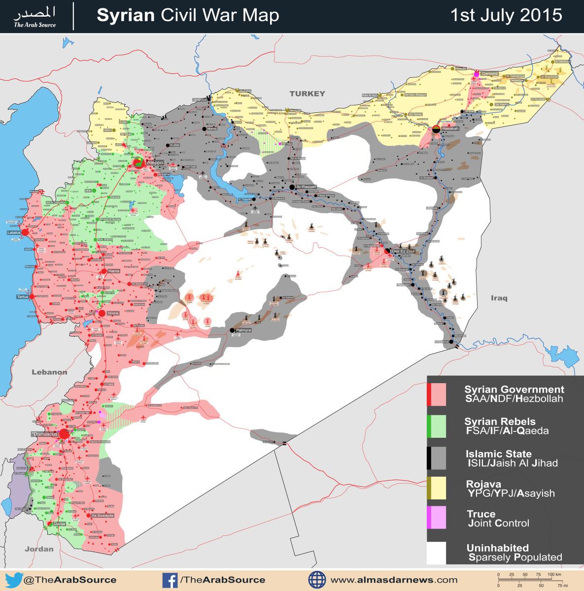
- First, we can't use maps. Second, that map is from al-Masdar, a biased pro-regime source. Third, that map copies this map. Pbfreespace3 (talk) 19:19, 7 July 2015 (UTC)
- Really, and I don't suppose you have any proof? XJ-0461 v2 (talk) 19:27, 7 July 2015 (UTC)
- First, look at the edit history on the module: sources were provided for each edit. Second, that map is definitely from al-Masdar, which is a biased pro-government source that calls any rebels 'terrorists' or 'al-Nusra', even when they are other Islamists. Third, look at the map. Its style and layout clearly mimic and copy from this map, which means it is a circular source. Fourth, ISIS moved on this area after the publication of this map. The map was published on July 1, whereas ISIS was only just moving in near Hisyah when this map was published. The purpose of the rural presence icon was to show that ISIS fighters from East Qalamoun had fled to this area. This will be important to show if ISIS attempts to cut of the government supply line from Damascus to North Syria. Pbfreespace3 (talk) 16:18, 8 July 2015 (UTC)
- Really, and I don't suppose you have any proof? XJ-0461 v2 (talk) 19:27, 7 July 2015 (UTC)
I do not remember the original source supporting this IS rural presence but I have not seen anything since. In any case the original source can be repeated? In any case the "Rural presence" was present before the map was published. I have a strong feeling that is an unsupported edit maybe due to occasional clash. If we have no additional confirmation it should be removed. The point is that this Rural Presence icon are hard to remove because they are very vague (how do prove that they are not there?).Paolowalter (talk) 20:30, 8 July 2015 (UTC)
- Agree. Unless proof is given (for example, a map showing their presence), it should be deleted. Im tired of unsourced edits or edits based on misinterpretations.--HCPUNXKID 16:22, 9 July 2015 (UTC)
Palmyra
SAA advancing around Palmyra and captured 3 area in the vicinity of Palmyra and also SAA captured Abu al Fawaris near Palmyra.https://www.facebook.com/syria.net/posts/865688856819792 https://www.facebook.com/Jaramana.N.N/photos/a.522699704465195.1073741859.144459405622562/840758009326028/?type=1 https://www.facebook.com/radioshamfm/posts/838551862864776 https://www.facebook.com/Division11.Tanks/posts/869292646484226 https://www.facebook.com/Alikhbaria.Sy/photos/a.391781824178176.85065.208881799134847/931229386900081/?type=1 https://www.facebook.com/www.documents.sy/posts/791817537584187 Also SAA captured village of Al-Bayarat is located directly west of the ancient city of Palmyra it is only 10 kilometers away from this aforementioned city.http://www.almasdarnews.com/article/syrian-army-recaptures-strategic-village-near-palmyra/ Saphyr66 (talk) 09:01, 8 July 2015 (UTC)
SAA and Hezbollah advance to the outskirt of Palmyra (Tadmur) recovering 11km into #ISIS land with the aim 2recapture the city. https://twitter.com/EjmAlrai/status/618754112029458432 Saphyr66 (talk) 12:15, 8 July 2015 (UTC)
- If this turns out to be true, this is very important, and I'm surprised more editors aren't looking at this. So far SOHR hasn't said anything, but I think their website is down, at least for me. — Preceding unsigned comment added by Pbfreespace3 (talk • contribs) 17:58, 8 July 2015 (UTC)
SOHR where never eager to report advance SAA. Rhocagil (talk) 18:49, 8 July 2015 (UTC)
SOHR website is up for me. It seems fine. I agree with Rhocagil, it might take them some time to report, since their sources for ISIS vs SAA conflicts are inside ISIS. XJ-0461 v2 (talk) 20:02, 8 July 2015 (UTC)
About SOHR. Hackers claiming to be affiliated with ISIS took down the website of the SOHR Wednesday and threatened its director. ISIS hasked SOHR website. http://www.dailystar.com.lb/News/Middle-East/2015/Jul-08/305737-isis-hackers-take-down-syria-war-monitor-site.ashx Saphyr66 (talk) 20:03, 8 July 2015 (UTC)
A few of places west of Palmyra were changed to red lacking sources clearly spelling their names as taken by SAA. The last new from Al Masdar http://www.almasdarnews.com/article/syrian-army-on-the-doorsteps-of-palmyra-numerous-villages-captured/ states between others that abu al Fawaris was taken by SAA. This plave is on our map but not on wikimapia. Anybody has more info? I remind that these places ar ein the middle of the desert, no way of having info from independent sources. Paolowalter (talk) 22:00, 8 July 2015 (UTC)
- According to EJM, 11km of territory were recovered from ISIS, but he does not specify which towns here: https://twitter.com/EjmAlrai/status/618754112029458432. It would appear that SOHR is down so that source is out for now. Perhaps if we were to change those villages from red to contested for now, since I do not see the SAA retaking or even attacking Palmyra in the near future. XJ-0461 v2 (talk) 00:18, 9 July 2015 (UTC)
SAA in coordination with the Tiger Forces and NDF – captured a number of sites in the west Palmyra countryside, including the strategic hill at Tal Al-Qal’at, which sits adjacent to this ancient city located in the deserts of east Homs. Following their advance at the collection of hills in the western Palmyra countryside SAAand the Tiger Forces carried out another powerful assault and capturing the Al-Qadri Farms after fierce clashes with ISIS. Tiger Forces the SAA and NDF are approximately 7.5 kilometers away from the ancient city and with recent success at the Jazal Mountains to the north, the Syrian Armed Forces are in prime position to besiege Palmyra from its northern and western flanks. http://www.almasdarnews.com/article/syrian-army-captures-al-qadri-farms-in-west-palmyra/ SAA advances-news report from the surroundings of Palmyra https://www.youtube.com/watch?v=ucDoQUh34Z8&feature=youtu.be Saphyr66 (talk) 07:44, 9 July 2015 (UTC)
SAA taking full control of Al-Bayarat. SAA also took control of Jabal Al-Qal’at, Burj Al-Ishara, Thaniyah Al-Rajmat, Bathar Al-Mazra’, Abu Al-Fawaress Quarries, Rawisiyah Abu Al-Fawaress, and Dhuhour Al-Hayal. http://www.almasdarnews.com/article/syrian-army-on-the-doorsteps-of-palmyra-numerous-villages-captured/
- SAA & Hezbollah are supposed to establish a demarcation line with ISIS at the gate of Palmyra city in few days.https://twitter.com/EjmAlrai/status/619041230060519424 SAA & Hezbollah advance near Palmyra. The gas field in Bay'yarat have been recovered. https://twitter.com/EjmAlrai/status/619040987520761856 SAA & Hezbollah advancing from d western gate of Palmyra in ISIS land and are about 4 km from the city entrance. https://twitter.com/EjmAlrai/status/619040679457480704 SAF reopening the road for advancing forces. https://twitter.com/EjmAlrai/status/619041567072874496 Saphyr66 (talk) 08:22, 9 July 2015 (UTC)
Hezbollah elite forces and SAA breaking ISIS lines around Palmyra registration more advance today toward the city under ISIS. https://twitter.com/EjmAlrai/status/619121000718864384 Attacking forces have an advantage, fighting in open land against ISIS on the road and the farms around Palmyra. https://twitter.com/EjmAlrai/status/619121314834460672 ISIS tried to counterattack but was pushed back by Syrian Air force covering the advance of the attacking forces toward Palmyra. https://twitter.com/EjmAlrai/status/619121558296985600 Initial attack was d gas fields but when attacking forces saw the road open (opportunity), forces were pushed toward the city now. https://twitter.com/EjmAlrai/status/619122464602230784 Still not clear if they want to enter city or establish a demarcation line. From forces involved, it seems they aiming for Tadmur. https://twitter.com/EjmAlrai/status/619122696056508416 Syrian army launches offensive to recapture Palmyra. http://news.xinhuanet.com/english/2015-07/09/c_134398206.htm So that according to reliable sources SAA retake most areas to west & south-west Palmyra and now prepare retake city. There are conflicting reports that the SAA entered into the city. Saphyr66 (talk) 13:35, 9 July 2015 (UTC)
SAA & Hezbollah advancing to western gate of Palmyra in #ISIS land and are about 4 km from the city entrance. https://twitter.com/EjmAlrai/status/619040679457480704 Probably here http://wikimapia.org/#lang=en&lat=34.559870&lon=38.234138&z=13&m=b&gz=0;382178306;345572544;444602;43117;61798;0;24032;2827;24032;2827;0;2827&search=Palmyra Saphyr66 (talk) 17:29, 9 July 2015 (UTC)
SAA near Palmyra https://www.youtube.com/watch?v=ucDoQUh34Z8&feature=youtu.be Syrian Observatory for Human Rights said government troops were now some five kilometers (three miles) west of the city and engaged in fierce clashes with forces from the extremist group. "Regime forces could enter the city at any moment, they are not far away and the area between them and the city is desert," Observatory director Rami Abdel Rahman said. http://www.dailystar.com.lb/News/Middle-East/2015/Jul-09/305917-syria-army-battles-isis-outside-palmyra-activists.ashx So SOHR said area west Palmyra under SAA. Saphyr66 (talk) 17:35, 9 July 2015 (UTC)
Ayn Issa
Ayn Issa has been edited 1, 2, 3, 4, 5, 6 times, today! If there is no consensus, and there doesn't seem to be, then why not leave it contested until more news comes out? Obviously some are reading the sources as it's IS held, other as it's Kurdish held. Clearly there's no agreement here. Either way, it's a front line. Magog the Ogre - help relieve edit warring? Boredwhytekid (talk) 01:32, 7 July 2015 (UTC)
- Both SOHR and Al-Masdar agree that IS took controk of the city. On the other side, there are a bunch of litte known 'activists' on twitter. There is no disagreement here, the rules of editing this page states clearly that Ayn Issa must go black.Paolowalter (talk) 07:00, 7 July 2015 (UTC)
- New SOHR report contradicts yesterday statement, so Ayn Issa seems in Kurdish control, it is not clear if IS was able to enter the city even yesterday. http://www.syriahr.com/en/2015/07/ayn-isa-witnsesses-calm-and-violent-clashes-erupt-in-the-western-sections-of-al-hasakah-province-and-the-coalition-bomb-the-area-heavily-and-violently/
- "the clashes coincided with coalition airstrikes which had an effective role in preventing IS from advancing further in the area of Ayn Isa and its vicinity", so IS is not anymore even near Ayn Issa. --8fra0 (talk) 08:14, 7 July 2015 (UTC)
- SOHR Report doesn't say Ayn Issa is back under YPG control only four villages which are not named in the vicinity of Ayn Issa. SO Ayn Issa is clearly IS control at the moment. Tgoll774 (talk) 12:07, 7 July 2015 (UTC)
- Now SOHR is reporting clashes in Ayn Issa: http://www.syriahr.com/en/2015/07/78-is-militants-killed-in-the-coalitions-airstrikes-and-clashes-with-ypg/ --8fra0 (talk) 13:03, 7 July 2015 (UTC)
- The situation seems to be unclear, with many different sides claiming different control statuses. In this situation, the only responsible thing to do is to change the town to contested. Pbfreespace3 (talk) 15:18, 7 July 2015 (UTC)
- Now SOHR is reporting clashes in Ayn Issa: http://www.syriahr.com/en/2015/07/78-is-militants-killed-in-the-coalitions-airstrikes-and-clashes-with-ypg/ --8fra0 (talk) 13:03, 7 July 2015 (UTC)
- SOHR Report doesn't say Ayn Issa is back under YPG control only four villages which are not named in the vicinity of Ayn Issa. SO Ayn Issa is clearly IS control at the moment. Tgoll774 (talk) 12:07, 7 July 2015 (UTC)
- https://www.youtube.com/watch?v=qBfTaRVA5TU&feature=youtu.be IS A'maq News has posted video evidence now showing IS soldiers in Ayn Issa and they give ample evidence to show the town under IS control. Ayn Issa should go Black. Tgoll774 (talk) 23:58, 8 July 2015 (UTC)
Pbfreespace3 your source justifying Ayn Issa to change to Lime/Yellow is https://twitter.com/markito0171/status/618840501874200576, which is not a valid source and Markito will be insulted to know he is considered a Pro-Islamist source when he is actually on no side but innocent civilians. I already used my revert, so someone else has to revert your unjustified edit. Also Markito isn't present in Syria, he is just reposting what he sees. Tgoll774 (talk) 01:26, 9 July 2015 (UTC)
- I concur. Markito is generally reliable but he's been wrong before. If you want to use his claims, ask him if he can provide sources. They are usually Arabic opposition sources, and they don't have the best track record in YPG-ISIS advances. The cluster of confusion in this four-way conflict is really causing an info blackout on the Kurdish-ISIS conflict. NightShadeAEB (talk) 14:08, 9 July 2015 (UTC)
- Agree. Pbfreespace3 unjustified edit should be reverted ASAP. Also, Markito (who isnt pro-ISIS, but clearly pro-FSA) didnt say that Ayn Issa was YPG-FSA controlled, but that they claim that they control it. So, according to the sources we have, Ayn Issa should return to black.--HCPUNXKID 16:19, 9 July 2015 (UTC)
- 8fra0 1. You linked a photo essay of the English SOHR site which is disregarded by Board Consensus. 2. Its not the actual SOHR report. We however, have video evidence IS controls Ayn Issa and the initial Arabic SOHR report. Self-revert your change or it will be done by others. Tgoll774 (talk) 18:22, 10 July 2015 (UTC)
- Agree. Pbfreespace3 unjustified edit should be reverted ASAP. Also, Markito (who isnt pro-ISIS, but clearly pro-FSA) didnt say that Ayn Issa was YPG-FSA controlled, but that they claim that they control it. So, according to the sources we have, Ayn Issa should return to black.--HCPUNXKID 16:19, 9 July 2015 (UTC)
Sarrin
YPG offensive arround Sarrin makes progress around Mighribtin. See:
There is no consensus with Map makers yet, so i suggest collecting reliable sources for the area around Sarrin here and then editing the map. 2.242.80.83 (talk) 08:35, 3 July 2015 (UTC)
- Chuck Pfarrer mentions Maghatatyn (seems to be Mighribtin on this map) as taken by YPG 5. Is this a reliable source (since it is mentioned in text not in map)? Chuck Pfarrer also implies on his map that a city called Saharij was taken by YPG which seems to be Tuba on this map. Can somebody confirm this is the same city?2.243.60.132 (talk) 19:46, 3 July 2015 (UTC)
- https://pbs.twimg.com/media/CJWLpJDWwAAc-Om.png:large From Res Publica at https://twitter.com/_paulo34/status/618554063853101056/photo/1. I don't see anything from IS or YPG on it. IS supporters say there is a media blackout on Sarrin and Ayn Issa though IS has release photos sets showing spoils taken from YPG around Sarrin without specifying where. YPG are denying everything and saying Sarrin will fall soon and say Ayn Issa was never taken, though SOHR, Regime, and now more Western Sources are confirming IS took it and Brigade 93. Right now this isn't enough to change the map and I'll personally revert changes made solely on this map if someone jumps the gun. But we must intensify our efforts to get sources on this spot to see if indeed IS has essentially broken the Sarrin Siege and is on the counter-offensive. Tgoll774 (talk) 14:38, 8 July 2015 (UTC)
- https://ia801506.us.archive.org/5/items/M3arek3enIslam/m3arek%203en%20islam.mp4 Can someone translate this? Tgoll774 (talk) 23:45, 10 July 2015 (UTC)
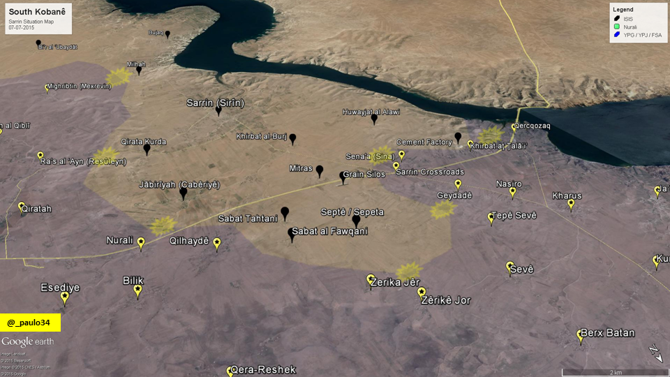
Removing Places like Villages and Areas
Pbfreespace3 I dont know why are you removing this e-syria-civil-war-1-june-2015_41967#11/34.4740/38.2654 places where they were added with a source to show which faction has presence and who is in controll of this places.You have to fix them,also can you add this place to beacause it is confirmed that the SAA captured this farms.46.99.22.173 (talk) 11:42, 11 July 2015 (UTC)
Brigade 93
Following the ISIL counter-offensive on Ain Issa, Brigade 93 has been shown as under ISIL control. Is this accurate? Prohibited Area (talk) 12:11, 11 July 2015 (UTC)
Souq Wadi Barada, Barahliya, and Kafr al-Awamid
ISW map shows all 3 as rebel held. Poking around, SOHR reports the area being barrel bombed on June 21st; SOHR reports the SAA shelling the area June 23rd; same fromJune 3rd; pro-op Syria Direct from the 25th and 23rd also claims the area is rebel held (with links to opposition organization's announcements from Wadi Barada and its environs); another pro-op source cites the same. Thoughts? Boredwhytekid (talk) 20:03, 25 June 2015 (UTC)
- I do not think we can use ISW maps. ISW maps show for example that the top left corner of the Damascus map is in truce and that much of the "green" area in the left bottom corner is red. However the "founder" of this map says we cannot use them, so he has reverted it to the old map. However maybe it is okay to use ISW maps if they show rebels gain, just not regime gains. Is that the thinking? — Preceding unsigned comment added by 169.231.25.10 (talk) 07:46, 26 June 2015 (UTC)
- Here is ISW map of Damascus, which the "founder" of this wiki page does not trust. He erased the accurate new map of Damascus loaded last week. Clear POV with no evidence to back his change up. http://iswsyria.blogspot.com/2015/06/the-regimes-offensive-campaign-damascus.html — Preceding unsigned comment added by 169.231.25.10 (talk) 07:51, 26 June 2015 (UTC)
- Well, we don't use other maps as SOLE sources - and I'm not advocating that we start. I linked the ISW as a supplemental resource to go with the other sources, to foster conversation on the topic. Boredwhytekid (talk) 12:09, 26 June 2015 (UTC)
- Well, the new Al Masdar map shows the Khan al-Shih area as our map is showing it now, and not like ISW map is showing it. You can notice at the top of the Al Masdar map the town of Zakyah (which is right to the east of Khan al-Shih) marked as rebel-held. So now go to the Al Masdar website and tell his editor that he is doing "Clear POV"! Tradediatalk 13:29, 26 June 2015 (UTC)
- You have said yourself that Al Masdar is not to be trusted and just copies our maps. Didn't you ask if a possible lawsuit could be brought against them?!? But now as they don't show the bottom left corner you are citing (to support your argument) Al-masdar's copy of our inaccurate depiction of Damascus. What a joke. Also the Al Masdar map rebel pocket to south-west of Damascus is no where near as big as the pocket as shown on this map. ISW has sources in Pentagon and is one of the most accurate think tanks reporting on Syria. Where is your evidence that the top left corner is not in truce? Where is your evidence that the bottom left corner is as big a rebel pocket as you claim it is? ISW is the only source that has provided an updated trusted map of Damascus and with sources that are anti-regime. The fact you reverted to the old inaccurate Damascus map shows how much your POV discolors this map.
- As far as I can judge, ISW are not accurate and should not be used. They were incorrect in the details in the past.
- The fact that they have original source in the Pentagon is questionable.
- As far as Wadi Barada is concerned, it has been often reported that there is a truce (also by pro rebel source, e.g. 23rd). Nevertheless it is a fragile truce and there are some clashes. On the Damascus page https://en.wikipedia.org/wiki/File_talk:Rif_Damashq.svg#Khan_al-Shih we concluded that this are a is on truce.
- As to Khan al-Shih maps are somehow contradictory. This map (that seems to be unbiased) https://twitter.com/Terror_Monitor/status/612116542134730753 show only the city of Khan al-Shih under rebel control. Honestly I have no stron opinion on this point. We can investigate further.Paolowalter (talk) 06:40, 27 June 2015 (UTC)
- Another POV. "as far as I can judge" and unsubstantiated claims of "incorrect in the details" is worthless to this map. Everyone makes mistakes, but ISW reports have been some of the most detailed, accurate, and substantiated. Now they show your Damascus map is heavily POV manipulated, and you won't fix it. You really must not know much about how DC think tanks work. ISW is funded by a who's who of the military industry industry in the US. See here: http://www.understandingwar.org/our-supporters
- Look at people running the group they are people involved in west point military academy, us army intelligence, national security council, us rangers, etc: http://www.understandingwar.org/who-we-are
- These people obviously have good funding and high level contacts, and are publishing some of the most detailed info anywhere on the war, and obviously are in touch with US military establishment. I'm surprised the map has not been fixed. I guess the founders POV trumps everything else. BTW, here are Pentagon brass meeting with graduates of the ISW educational program: http://hertogwarstudies.org — Preceding unsigned comment added by 71.107.130.24 (talk) 08:21, 27 June 2015 (UTC)
- Explain to me one thing: How can the gov take back al-Dirkabiya, Zakiyah, al- Mqelabiyya, al-Taybeh in a strategic area near Damascus city and besiege Khan Al-Shih and no one on the internet mentions it? A more likely scenario is that the person who did the map for ISW was told that Khan Al-Shih was rebel held, and didn’t realize that there was a whole pocket around it & not just the town by itself. We are not contesting the prestige of ISW as an institution. However, over time, ISW maps have been found to be full of mistakes (not just only a few, as it should be). We blamed this on “approximations”. The video that you link (http://hertogwarstudies.org) and that shows “Pentagon brass meeting with graduates of the ISW educational program” is interesting. Unfortunately, it is not the “Pentagon brass” that are drawing their maps, but more likely interns or students. Looking at their students in the video, I do not feel they follow or know the situation in Syria as much as we do.
- For example, back in August 2013, I had a good impression of ISW and have even proposed its use in a conversation on my talk page (User talk:Tradedia#Mapmaking). I said: “…By the way, have you seen: http://www.understandingwar.org/backgrounder/opposition-advances-damascus? It has a map on it that might be useful as a source…” However, the editor I was talking with, rightfully noted problems when he replied: “…I've seen that ISW report, but I have to say I'm a bit skeptical of it. I have not seen reports of clashes in the districts of central Damascus that it claims are contested, nor are they backed up in the report itself…” If you look around talk archives, you will find many discussions concerning serious problems with ISW maps.
- By the way, the Al Masdar map's rebel pocket is not smaller than the one on our map. Only the southern part of the pocket is visible because it is truncated by the frame of the map. However, if you look at their map of the whole of Syria you then can see the whole pocket and notice that it is as big as the one on our map. Also, Desyracuse map from 1-june-2015 shows the rebel-held pocket as our map is showing it. And if you click on the purple information dot to the east end of the green pocket, you can read that the map maker wrote a note saying: “On May 23, rebels captured Tayyibah farms, advancing toward Al Kiswah”. So it seems like the pocket has expanded lately and not shrunk…
- In addition, on June 13, 2015, SOHR reported “The regime forces opened fire on areas in the road between the towns of Khan al-Shih, Zakya and al- Mqelabiyya in west of Rif Dimashq and on areas in al- Mqelabiyya town, information about injuring of some people in al- Mqelabiyya town.”
- Concerning the map that Paolowalter linked (https://twitter.com/Terror_Monitor/status/612116542134730753) and that was dated June 20, they now came out with a more up-to-date version (dated June 29) that shows the rebel-held pocket as our map is showing it! So it seems that they had copied the ISW map, but then read our talk page and corrected their mistake!
- Concerning "the top left corner", I already indicated (in Talk:Cities and towns during the Syrian Civil War/Archive 49#Damascus map? Why was it reverted to old inaccurate map?) that I was OK with it being changed to "purple", but this time based on a real source (news report: http://www.almasdarnews.com/article/rebels-cut-water-supplies-feeding-damascus/). Tradediatalk 16:09, 29 June 2015 (UTC)
- Lots of assumptions and claims made above without evidence. Al Masdar map just copied the wiki map, and so included that big pocket, and Desylacuse is pro-rebel and often makes many false marks on their map to show rebel positions in places they don't exist. this is widely known. Maybe green in bottom left is bigger then the newer map that was updated (and then taken down) but you present no evidence showing the pocket is as big as it currently is placed on the map. zero evidence. just claims and assumptions. Some months ago regime with allies sent a lot of troops down below this pocket and could have easily shrank this-- we just don't know. My suggestion is to turn part of the green pocket area in south left corner to dark green contested but to keep the towns green where we know rebels are in control. this areas have been cut off from supply for a long time and are not heavily population. Of course the top left corner is never changed to purple, even though Tradeia agrees it should be. And other biased POV posters on this page provide no evidence this area is not in purple. so change that to purple. — Preceding unsigned comment added by 169.231.25.10 (talk) 05:23, 1 July 2015 (UTC)
- I am not the one who is requesting a change on the map. So I do not need to provide any evidence. It is the person who requested the change, that needs to provide evidence. It is that person that needs to present evidence showing the pocket is smaller than the one we had on the map. That person only provided an obviously incorrect map that is contradicted by literally every other source. The gov could have done things, but as you say “we just don't know.” We cannot update the map based on what could have happened, but rather based on what has happened and is documented. If the gov did indeed shrink the pocket, don’t you think at least one pro-gov source would have talked about it? Absolutely no one has talked about it.
- Concerning “the top left corner”, you have to realize that changing the “Damascus city map” requires knowledge of graphics software, so there are not a lot of people who can do it & they are usually very busy & overwhelmed with update demands (I don’t know how to edit pictures myself). So it always takes time to update the “city maps”. Tradediatalk 09:34, 1 July 2015 (UTC)
- How does ISW map showing bottom left hand corner "contradict" "literally every" other source? Other than pro-islamist sources, you have no sources justifying this big pocket. You say you do, but when one actually looks at these sources they don't show what you claim. Business Insider map here does not have the same sized massive green pocket: http://www.businessinsider.com/map-of-syria-shows-what-isis-is-truly-fighting-for-2015-6 Al Masdar map here has green pocket but not as big as ours, see here: http://www.almasdarnews.com/article/battle-map-syrian-civil-war-july-2015/ Do you have any non-islamist rebel sources that show the pocket as big as the wiki map? And ones that don't just copy from wiki? Again, I suggest making part of left bottom pocket as dark green, until more sources are gathered and top left corner as purple. I realize it takes time to change, so we can wait and allow programmer to fix it. I still don't think you can just trash ISW report so quickly- and as shown above they have very strong linkages with US defense industry and military-intel complex. They reposted the map in another report here : http://iswsyria.blogspot.com/2015/06/the-regimes-offensive-campaign-damascus.html The map also I believe has a more accurate outline of Eastern Ghouta suburbs pocket, in comparison to wiki outline. — Preceding unsigned comment added by 169.231.25.10 (talk) 04:07, 2 July 2015 (UTC)
You want to talk about pocket size? OK, lets do this. Lets use as a reference, rebel-held Darayya:
- On the Business Insider map, the Khan al-Shih pocket is represented as about 2 times larger than Darayya.
- On the Al Masdar map, the Khan al-Shih pocket is represented as about 3 times larger than Darayya.
- On the Islamic World News map (the one linked by user Paolowalter), Darayya is not represented, however the Khan al-Shih pocket is similar in size to that of Al Masdar map. So the Khan al-Shih pocket is represented as about 3 times larger than Darayya.
- On our map, the Khan al-Shih pocket is represented as about 5 times larger than Darayya.
- On the ISW map, the Khan al-Shih pocket is represented as about 10 times SMALLER than Darayya.
Do you see a pattern here? The ISW map is an outlier. So it is contradicted by all other maps, including all pro-gov maps (Al Masdar and Islamic World News; can you find any more?). All maps (including ours and excluding ISW) have the same order of magnitude. On the other hand, the ISW map has a different order of magnitude. All maps (including ours) are apples. The ISW map is an orange!
Now, how do we know which size on which map is closer to reality (excluding ISW)? How do we know that the size in some map is based on information and not on guessing, mistake or bias? What we do on our map is that we do not look at other maps, but rather look at real sources (news reports). News reports will tell us which towns are rebel-held, which towns are contested, and which towns are gov-held. This then determines the size of our pocket.
And the best for last: here is the latest ISW map released July 2. Do this look correct to you? Now Khan al-Shih is shown gov-held! And Hadar rebel-held! What a joke… Tradediatalk 00:02, 4 July 2015 (UTC)
- Thank you for posting the graphic. However, the kilometers you assign to the business insider map look too much. Also, didn't you say that the Al Masdar map just copies us? Also if you compare these, are not we (the wikipedia map) also an outliner? Our pocket is much , much bigger then all the rest. — Preceding unsigned comment added by 169.231.25.10 (talk) 01:24, 4 July 2015 (UTC)
Concerning the business insider map, it is not easy to estimate the pocket size because the map is not as detailed as the others and Darayya is represented by a dot and the Khan al-Shih pocket seems to be represented by 2 (connected) smaller squares for 2 towns…
Concerning our map, it is not an outlier. Let me add the maps by Thomas van Linge, Desyracuse, and Archicivilians:
- On the Thomas van Linge map, the Khan al-Shih pocket is represented as about 6 times larger than Darayya.
- On the Desyracuse map, the Khan al-Shih pocket is represented as about 9 times larger than Darayya.
- On the Archicivilians map, the Khan al-Shih pocket is represented as about 9 times larger than Darayya.
So our map looks like it is in between the pro-gov maps & the pro-opp maps.
Now, how do we know which size on which map is closer to reality? For all these maps, we do not know how the map maker decided on the size & shape of the pocket. Did he base it on reliable information? Or rather on guessing? Or is it bias? Or just a mistake? Or mindless copying of another map? There is no way to know. What we do on our map is that we do not look at other maps, but rather look at real sources (news reports). News reports will tell us which towns are rebel-held, which towns are contested, and which towns are gov-held. This then determines the size & shape of our pocket. Tradediatalk 03:39, 12 July 2015 (UTC)
Siege Broken!
According to pro-kurdish source Isis has broken the siege on Khirbat al Burj and the Grain silos and captured Mitras!46.99.33.8 (talk) 15:06, 13 July 2015 (UTC)
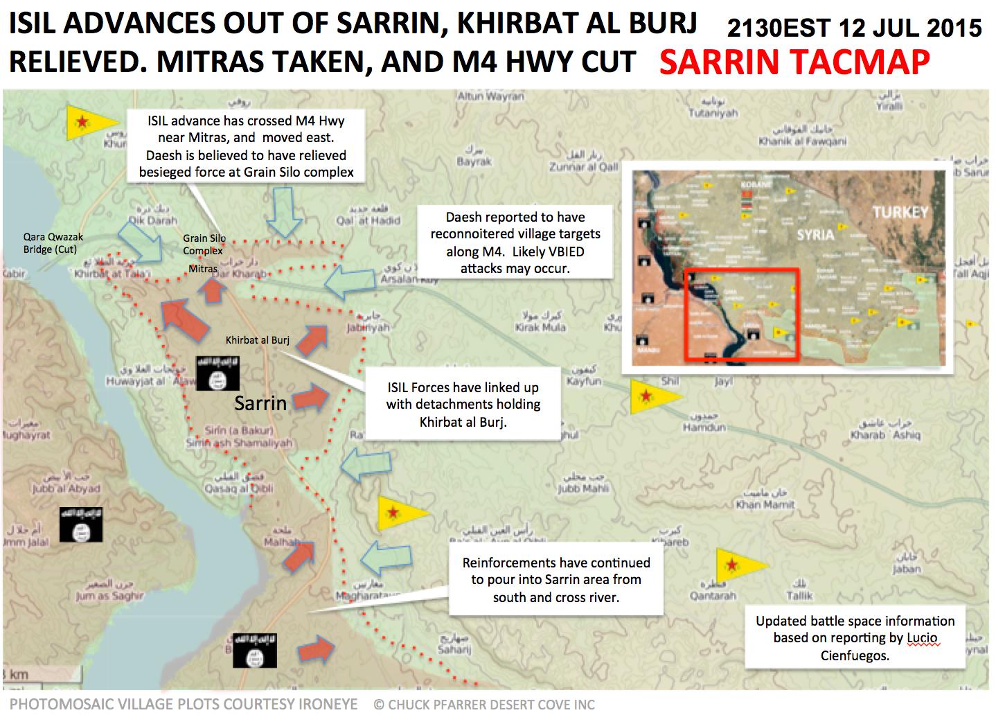
Important changes Homs/Hama
This issue may be solved by Tradedia who knows how to find good sources for specific areas. Let's just analyze this year, i have seen like 100 SOHR reports that Government forces are
- a) dropping barrel bombs on Houla area
- b) targeting Houla area with airstrikes
- c) clashes in the vicinity of Houla area
This is only SOHR, rebel sources are reporting the same. How come that we have so much sources for just 1 location and we have that entire location marked red on our map ? This is the region I'm talking about, if you hover with the mouse over it, you can see how big it is. DuckZz (talk) 21:17, 12 July 2015 (UTC)
Houla Region (Tal Thahab&Taldou&Kafar Laha it is region under FSA) Here: http://wikimapia.org/#lang=en&lat=34.814367&lon=36.478043&z=11&m=b&show=/26550789/Houla-Region not Houla plain Saphyr66 (talk) 06:18, 13 July 2015 (UTC)
The Houla Region or Houla Plain (Arabic: الحولة al-Ḥūlāh) is an area consisting of three villages in the Homs Governorate of central Syria, northwest of the city of Homs. The biggest village in the Houla region had 20,041 inhabitants in 2004 and is called Kafr Laha. The second largest village, Taldou, had 15,727 inhabitants in 2004 and is located in the outskirts of Houla. The third village, Tell Dahab had 12,055 inhabitants in 2004. https://en.wikipedia.org/wiki/Houla — Preceding unsigned comment added by Saphyr66 (talk • contribs) 06:27, 13 July 2015 (UTC)
- This is just the latest SOHR report from today about Houla area being targeted by airstrikes
- These are 2 rebel pages from Houla, here1 and here2
- This is a channel where we can see the airstrikes
All of them just say "Houla area or Houla town", and they say besieged, but i can't figure out do they only mean the Houla town or all 3 towns in Houla area (Houla, Tall Dhahab and Taldou). Other SOHR reports are enough to mark 1 town green (basically every few days), but what about the rest, i will not edit anything until this area is clear and disqussed DuckZz (talk) 15:40, 13 July 2015 (UTC)
Suluk and Aliya
Suluk and Aliya, deep into YPG/FSA held territory, were edited to contested 4 days ago, citing this source: http://aranews.net/2015/07/kurds-fortify-southern-kobane-to-deter-isis-attacks/ Given that no further news have emerged confirming the clashes there, I suppose that: A) Aranews published a fake news (many times before they published unconfirmed news); B) or Aranews meant Aliye and Suluk [countryside]. I suggest to revert those two towns to Kurdish control. --8fra0 (talk) 08:52, 13 July 2015 (UTC)
I think you are right, we should revert the edit. And probably the source means "B) or Aranews meant Aliye and Suluk [countryside]". Source also says that “but the joint forces were able to deter IS progress and kill dozens of them with the support of the coalition’s air strikes”. Where the source refers to “The clashes are still ongoing in these areas", it is talking about the southern Kobane area.Rhocagil (talk) 20:50, 13 July 2015 (UTC)
Al-Ghab Plain-Hama
Acc. to pro opp Step.News.Agency , SAA captured Qabr Fiddah - Al Shari`ah - Karim and Ramleh https://www.facebook.com/Step.News.Agency.Sy/posts/638335749635044 location: http://wikimapia.org/#lang=en&lat=35.481501&lon=36.330929&z=13&m=b&gz=0;363118743;354299734;144195;0;564765;145455;166511;706053;0;678102;0;261521;159645;9791 Hwinsp (talk) 18:48, 4 July 2015 (UTC)
- Confirmed by pro government source. Changes should be made. MesmerMe (talk) 11:36, 5 July 2015 (UTC)
- I do not have time now, but I can fix it later this week if no one else did. Also this source Ivan Sidorenko Rhocagil (talk) 13:35, 5 July 2015 (UTC)
- The original Arabic report from Step.News.Agency says "الأشرفية" = Al-Ashrafiyah not Al Shari`ah. So I don’t know where he translated Al Shari`ah from. Besides here Ivan Sidorenko says it is not confirmed. Also Al Masdar says Al-Ashrafiyah not Al Shari`ah. Qabr Fiddah & Karim were already red on our map. Another mistake (thanks map copying!) So Al Shari`ah should go back to green. Tradediatalk 03:39, 6 July 2015 (UTC)
- I do not have time now, but I can fix it later this week if no one else did. Also this source Ivan Sidorenko Rhocagil (talk) 13:35, 5 July 2015 (UTC)
I have changed to red or added Al Shari`ah, Huwayz, Qabr Fiddah, Al Kareem. Probably Al Shari`ah was already changed, sorry, following http://www.syriahr.com/2015/07/%D8%A7%D9%84%D9%85%D8%B2%D9%8A%D8%AF-%D9%85%D9%86-%D8%A7%D9%84%D8%B4%D9%87%D8%AF%D8%A7%D8%A1-%D9%81%D9%8A-%D8%A7%D9%84%D9%82%D8%B5%D9%81-%D8%A7%D9%84%D8%AC%D9%88%D9%8A-%D8%B9%D9%84%D9%89-%D8%A7%D9%84/ http://www.almasdarnews.com/article/battle-map-and-analysis-of-the-al-ghaab-plains-syrian-army-advances-westward/ and https://twitter.com/Amin_Akh/status/617815282896269313.Paolowalter (talk) 10:05, 6 July 2015 (UTC)
- If you had read my message above, it would have saved you some work. In addition to what i said, I add that your first 2 sources mention "الأشرفية" = Al-Ashrafiyah not Al Shari`ah. Also, your 3rd source says: "Clashes continue on al_Shari`ah". But we cannot use it because it is pro-gov. So Al Shari`ah should go back to green (with red semi-circle), and the duplicated Qabr Fiddah & Karim that you added should be removed. Tradediatalk 02:27, 7 July 2015 (UTC)
- I did not read your message before, but Al-Ashrafiyah and Al Shari`ah most likely coincide. I could not see other alternatives.
- Furthermore from http://www.syriahr.com/en/2015/07/shelling-leaves-casualties-in-sahl-al-ghab/ also al-Qahera is under SAA control
- but I cannot find it. I'll look for duplications.Paolowalter (talk) 07:22, 7 July 2015 (UTC)
- Seems like you don't read the sources you provide either... The first sentence of the SOHR link you provide talks specifically about al-Shari’aa and al-Ashrafyyeh as 2 distinct towns. So Al Shari`ah should go back to green (with red semi-circle). Tradediatalk 10:06, 7 July 2015 (UTC)
- Also, I did a google search for the town of Latmin (لطمين) and found the following (no evidence of recent clashes in the town):
- There is a pro-gov source (from June 13) saying “the Army Air Force launched intensive strikes on dens of terrorists in … Latmin”
- Then there is the neutral Rai al-Youm (edited by the famous Abdel Bari Atwan) talking about the town as “being on the frontline with gov troops” (July 5).
- There is also SOHR talking about “gov bombing on the town” (13 June).
- Then there is pro-opp Hama Coordination Committee talking about: “barrel bombing on the town” (07-07-2015).
- Therefore, Latmin should be turned from contested to green. Tradediatalk 03:41, 8 July 2015 (UTC)
No, the only thing proved by your sources is the city is at least partially held by rebels, so that it could be contested. In the past consensus was reached not to accept vague statements like "city was bombed" as proof that it is under control by one side. The most robust confirmation of the status of Latmin is in https://twitter.com/TheArabSource/status/618505067293859840. It is under rebel control but on the front line (as supported by the second of your sources). Therefore green with red half-circle on east.Paolowalter (talk) 20:36, 8 July 2015 (UTC)
According to AL-masdar (article here) SAA are advancing in Ghaab Plains. Is there conformation from other sources about this??Rhocagil (talk) 00:33, 15 July 2015 (UTC)