
Talk:Control of cities during the Syrian civil war/Archive 55
| This is an archive of past discussions. Do not edit the contents of this page. If you wish to start a new discussion or revive an old one, please do so on the current talk page. |
| Archive 50 | ← | Archive 53 | Archive 54 | Archive 55 | Archive 56 | Archive 57 | → | Archive 60 |
Military objects around Kweires
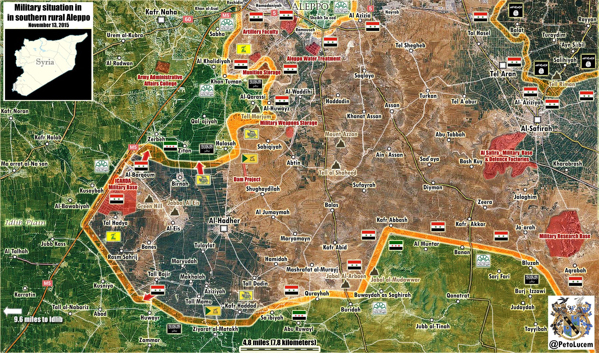
We have 2 objects near Kweires Airbase marked red: Military housing and air defense base. Do we have any recent proofs that they are really under SAA control? Even pro-SAA sources are giving distance estimates (between besieged and other forces) that makes me think they need to go all the way to the airbase perimeter, and not some objects outside the base. --Hogg 22 (talk) 15:05, 9 November 2015 (UTC)
Usually I would not say this but what a stupid question!!! It is well known these military housing (Which is ajoined to Kurweas Airbase) is under SAA control because it is all part of the same base, ISIS have had hundreds (575) of their men killed trying to penetrate the military housing, over the last 4 months. Now have you a legit source to show that it is not in SAA hands? produce it if so, it is hard to think that you are involved with a lot of editing on this map and you ask such a brainless question. — Preceding unsigned comment added by 193.1.100.66 (talk) 16:27, 9 November 2015 (UTC)
We shouldn't tolerate such insulting language here! Hogg22 posed his/her question in good faith. That "unsigned" has info on IS's numerous failed attempts at storming the military housing complex doesn't make it unreasonable to someone else without this info that it may not still be in the SAA's hands. The base is large enough for the IS to have possibly occupied peripheral structures over the years that it has been besieged, while the defending troops hold on to the core areas of the base. — Preceding unsigned comment added by 104.129.196.85 (talk) 00:37, 10 November 2015 (UTC)
- Dear Mr 193.1.100.66, who is unable to sign own comments, and yet call other people brainless :)...
- Air defense site and Military Housing are administratively part of the Airbase, but not phisically. They are both separated from the walled compound by empty fields, just like nearby village Karkiz that used to be under SAA control, but it isn't anymore. I believe IS suicide bombers have more respect for walls then for administrative borders. What I was saying is Shekh-Ahmad is only 1.4 km from Military housing and 2.5 km from walls of the Airbase and yet none ot the pro-SAA sources that reported capture of Shekh-Ahmad don't say SAA neds only 1.4 km to lift the siege. Did You get my point now? --Hogg 22 (talk) 08:06, 10 November 2015 (UTC).
- I have no idea how anyone could get reasonable info on those sites, you'll found out in the coming hours/days if SAA makes the final push I guess.Totholio (talk) 08:58, 10 November 2015 (UTC)
- I found one recent info that says "#SAA cadets attacking #ISIS from the north: military housing of #Kuweires #Kweires". Also, one old (9 May 2015) source Oryx Blog: Battlefront Syria: Kweres airbase mentions street battles inside compound that seams to be walled and says it's fall would endanger the airbase. This article seams interesting, but I didn't have time to read it to the end. Anyway, seams to be under SAA control. --Hogg 22 (talk) 09:21, 10 November 2015 (UTC)
- Well, Kuweires siege is broken now if the housing and base was captured it should be liberated in the coming hours.Totholio (talk) 15:46, 10 November 2015 (UTC)
Map/Jinan
Regarding the map I think there are some mistakes in some places,example Jinan where it's shown goverment held since ever and now Al-Masdar report that this village is just captured by the syrian army from Isis.Lists129 (talk) 19:25, 9 November 2015 (UTC)
- Wrong city, this is the one: http://wikimapia.org/32720032/ar/%D8%AE%D8%B1%D8%A8%D8%A9-%D8%AC%D9%86%D9%8A%D9%86%D8%A9 MesmerMe (talk) 19:58, 9 November 2015 (UTC)
- MesmerMe thank you for your help :).Can I ask you if you have information on this villages Dukaylah,Sulaytiyah,Tall al Albawi,Tayyibah,Rasm ad Dab,Mukaymin al Qibli,Rasm al Ahmar,Jubb al Abyad,Rujm al Kharaf beacause this areais empty on the map.Lists129 (talk) 20:27, 9 November 2015 (UTC)
- This area has so incredibly little information coming out if, it'll nearly impossible until one of the parties makes any movement towards the frontlines. MesmerMe (talk) 17:41, 10 November 2015 (UTC)
- MesmerMe thank you for your help :).Can I ask you if you have information on this villages Dukaylah,Sulaytiyah,Tall al Albawi,Tayyibah,Rasm ad Dab,Mukaymin al Qibli,Rasm al Ahmar,Jubb al Abyad,Rujm al Kharaf beacause this areais empty on the map.Lists129 (talk) 20:27, 9 November 2015 (UTC)
N Lattakia / Hasakah
A pro-SAA source Syrian Arab News Agency mentions list of rebel-controlled villages:
- dens of terrorists in al-Karoura Mountain, Arafeet, Okober, al-Zweik, al-Darmashliyeh, Deir Hanna, Kabaneh and katef al-Ghadr and Katef al-Ghanameh in the north eastern countryside of Lattakia.
Can someone help me find them and add them to the map? --Hogg 22 (talk) 09:41, 10 November 2015 (UTC)
Also on Al-Halw/Hasakah front: aranews.net reports:
- ...The SDF troops regained control of the villages of Zaniya, Yezidiya, Suwefat in the eastern countryside of Hasakah....
- ...have also recaptured the villages of Salaliya and Rajm Sharqi south of Hasakah...
--Hogg 22 (talk) 11:42, 10 November 2015 (UTC)
- Salaliya [8], Rajm Sharqi? [9] Schluppo (talk) 18:59, 10 November 2015 (UTC)
Kuweires military housing
Shouldn't the icon of Kuweires military housing be a military base icon instead of a normal icon used for villages and cities? — Preceding unsigned comment added by 93.161.56.11 (talk) 21:44, 10 November 2015 (UTC)
clashes in Morek per pro red sources
SOHR and pro red facebook pages states clashes in Morek and Rebel controlling parts of it. Facebook pro rebel pages claim full rebel control on Morek. I say it goes contested any ideas about that ? Helmy1453 (talk) 21:32, 4 November 2015 (UTC)
Interestingly enough Pro-gov sources I've seen are calling it a tactical retreat with no loss of life while rebels are claiming they are still fighting gov troops in the city — Preceding unsigned comment added by 2601:741:0:9182:A9C7:6458:4A0E:95D5 (talk) 22:09, 4 November 2015 (UTC)
What percent of Morek are controlled by insurgents?
That's the most recent source who I have --LogFTW (talk) 09:27, 5 November 2015 (UTC) http://www.almasdarnews.com/article/breaking-syrian-army-reenters-the-strategic-town-of-morek-with-the-help-of-hezbollah/
We should in this instance be wary of using Al-Masdar. Masdar claimed the little towns of Mughayr and al-Bani under SAA control. Suddenly, Mughayr was taken by the SAA when they first assaulted Kafr Nabudah. al-Bani was suddenly disputed with the NDF moving towards the rebel-held checkpoint in the north. Same for Tell Othman: changed to red per Masdar, but no other source has mentioned it. Also, Masdar states that the SAA "took control of the southern entrance" of the town. This means:
- Morek should be green with a red ring in the south
- The checkpoints north of Morek are rebel held. There is enough video proof en geo-locating to check it. Also, the army wouldn't attack from the south only if it still held the northern Tank Batallion and other checkpoint on the M5 highway.
- Tell Othman should be contested until we have more information — Preceding unsigned comment added by 84.31.204.195 (talk) 11:25, 5 November 2015 (UTC)
Sources for making Morek fully rebel held:
- http://english.alarabiya.net/en/News/middle-east/2015/11/05/Syria-rebels-seize-key-regime-town-on-Hama-Aleppo-road.html
- http://timesofindia.indiatimes.com/world/middle-east/Syria-rebels-seize-key-regime-town-on-Hama-Aleppo-road-Monitor/articleshow/49672935.cms
- http://www.trust.org/item/20151105082609-rdtqm
- http://www.businessinsider.com/r-rebels-down-government-air-force-plane-in-western-syria-monitor-2015-11?IR=T — Preceding unsigned comment added by 84.31.204.195 (talk) 11:29, 5 November 2015 (UTC)
Clashes are still taking place inside Morek: [11] Schluppo (talk) 12:18, 5 November 2015 (UTC)
Alright, but that still leaves the northern and eastern checkpoints. They are shown as red, whilst both Masdar, SOHR and neutral sources mention only fighting in the south of the town. They should be green. — Preceding unsigned comment added by 84.31.204.195 (talk) 12:55, 5 November 2015 (UTC)
Pro-gov map of the area; Tall Sukayk and Tall Othman are both rebel controlled, https://twitter.com/PetoLucem/status/662345513342271492 — Preceding unsigned comment added by 199.67.17.19 (talk) 19:12, 5 November 2015 (UTC)
- twitter map this map is so poular now on twitter and facebook. I know twiter and specially maps are not reliable but, this map is in agreement with our map on every other portion, also it makes more sence than ours neer Morek . can we make an exception and use it for once ? Helmy1453 (talk) 19:49, 5 November 2015 (UTC)
Agreed. Peto Lucem is the head of Al-Masdar news channel. His maps are also published on that site. The fact that pro-SAA editors make maps that show Tell Otman as rebel held is enough for us. It would be impossible for rebels to attack al-Bani if they did not control the hill and the road alongside it. — Preceding unsigned comment added by 84.24.43.183 (talk) 10:52, 6 November 2015 (UTC)
Peto Lucem is not head of AL Masdar and has nothing to do with it .Al masdar just use his maps — Preceding unsigned comment added by 86.135.154.78 (talk) 15:31, 8 November 2015 (UTC)
- Here is another pro-SAA map showing Tell Otman under control of the rebels [12]. Schluppo (talk) 05:45, 11 November 2015 (UTC)
Villages and Checkpoints on detail maps
Is it a correct observation that only military checkpoints get an extra symbol in areas that are covered by a detail map? Villages and hills do not get marked when they are located in an area that is covered by a detail map, right? I removed Tall Riman and Salihiyah which are covered by the Aleppo detail map, but my changes have been reverted. Schluppo (talk) 10:48, 11 November 2015 (UTC)
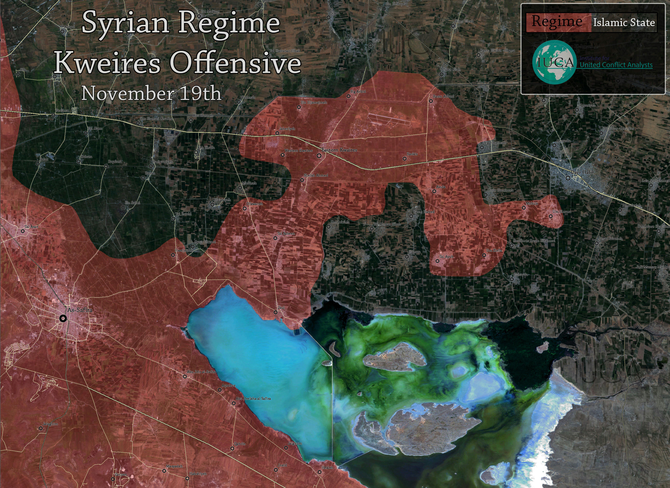
Kuweiris
Kuweiris is relieved, together with the towns of Rasm Abbud (which is on the map), and Umm Arkilah. And the SAA is currently on the outskrits of Tall al Ahmar. MesmerMe (talk) 17:40, 10 November 2015 (UTC)
- Furthermore, the map has to show more areas towards the east to Umm Arkilah. I do not know who is in charge of those in map pictures. MesmerMe (talk) 19:22, 10 November 2015 (UTC)
- confirmed by Al Masdar news .86.135.154.78 (talk) 19:46, 10 November 2015 (UTC)
- Rasm Abbud should be red .86.135.154.78 (talk) 11:02, 11 November 2015 (UTC)
- It is red. --Hogg 22 (talk) 11:17, 11 November 2015 (UTC)
Tell Othman, Hama
Somebody deleted my post, so here it is yet again.
Tell Othman was taken by rebels a week ago. We reverted it to SAA-control because of one Al-Masdar source. And what happens today? Excactly: Al-Masdar releases an article with a map, and it shows Tell Otman well behind rebel lines. So the hill should be green.
Source: http://www.almasdarnews.com/article/understanding-the-syrian-armys-strategic-loss-at-morek-where-do-they-go-from-here/ — Preceding unsigned comment added by 84.24.43.183 (talk) 11:18, 11 November 2015 (UTC)
Tips on loading into google earth?
I hope this is the right place to discuss this. I am a longtime editor with journalistic and academic interest in the region; I believe this page is one of the most important publicly accessible references anywhere in the world apropos of the Syrian civil war. It would be even more useful if anyone were able to figure out how to make the current version (and possibly archived old versions) exportable as a Google Earth layer. I understand that this is not strictly speaking a purely wikipedia question, but I believe this map's importance is such that the possibility of layering it in Google Earth should be seriously discussed. I am going to have a go, but suspect there are others here who could do it easier and better than I. jackbrown (talk) 18:05, 11 November 2015 (UTC)
Fajdan
Fajdan, south of Safira, has had a green half circle for months, if not years, but I have absolutely never seen any reporting about this whatsoever. Could anybody provide a source, or remove the half circle. MesmerMe (talk) 11:30, 12 November 2015 (UTC)
Tel Othman, Hama
Recently, rebels took Tell Othman near Kafr Nabudah. The hill was then changed back to red because Al-Masdar (as only source) reported that the SAA had retaken the hill. And what do we see today? An Al-Masdar article, showing a map in which Tell Otman is several kilometers behind rebel lines in Al-Bani. So the hill should be green, as was pointed out a week ago.
Source: http://www.almasdarnews.com/article/understanding-the-syrian-armys-strategic-loss-at-morek-where-do-they-go-from-here/ — Preceding unsigned comment added by 84.24.43.183 (talk) 10:06, 11 November 2015 (UTC)
Also, somebody changed Mugahyr, the grain silos and Tell Sakhr to red. The Al-Masdar map also shows those locations as rebel-held. Change it back. There have been no sources given on this page that justify the change! — Preceding unsigned comment added by 84.24.43.183 (talk) 11:20, 11 November 2015 (UTC)
- After publishing the map that you refer to, al-Masdar reported in another article that Mugahyr, the grain silos and Tell Sakhr were taken by SAA. This report was given as a source for the edit, so the edit is perfectly fine. 109.43.2.191 (talk) 12:00, 11 November 2015 (UTC)
Then it should be contested? If one source reports on the same day that a village is rebel held and loyalist held, something is amiss. Since no other sources are reporting anything about a SAA counterattack, we should be cautious. Also, the hill is still not edited? — Preceding unsigned comment added by 84.24.43.183 (talk) 16:56, 11 November 2015 (UTC)
- The latest reliable source wins. Also we cannot rely on maps. 109.43.0.239 (talk) 22:33, 11 November 2015 (UTC)
The latest reliable source is the map from al-Masdar? The article doesn't mention tell Otman as retaken. so, edit the hill! — Preceding unsigned comment added by 84.31.204.195 (talk) 13:56, 12 November 2015 (UTC)
- Regarding Mugahyr, the grain silos and Tell Sakhr, the latest reliable source appears to be [14], stating that these places are under SAA control. Regarding Tell Othman, we cannot rely on maps, so we have to rely on the latest reliable source with text about Tell Othman. This appears to be [15] which was used to color Tell Othman red about one week ago. Since then, there was apparantly no reliable source stating that rebels retook Tell Othman. However, if you have a newer RELIABLE source that is NOT A MAP and states that the rebels retook Tell Othman, Mugahyr, the grain silos or Tell Sakhr, please provide it. Schluppo (talk) 16:04, 12 November 2015 (UTC)
Southern Aleppo
I think some towns in villages in Southern Aleppo are displayed quite larger on the map than they are in reality. Could someone have a look on this? Oberschlesien1990 (talk) 11:44, 13 November 2015 (UTC)
Is there an admin familiar with rules for editing this map?
It seams we have a problem with one stubborn user: User:LightandDark2000. Multiple users complained about his editing of the map, but he ignored everything and even deletes all complaints from his talk page. Which admin should I contact to discipline him? --Hogg 22 (talk) 12:24, 12 November 2015 (UTC)
- Indeed, this user is repeatedly breaking the rules, e.g. using partisan tweets as source and re-reverting anyone that reverts such edits. User:LightandDark2000: Please, adhere to the rules or stop editing! Schluppo (talk) 16:08, 12 November 2015 (UTC)
- I raised this issue on Wikipedia:Administrators' noticeboard/Incidents. --Hogg 22 (talk) 11:45, 13 November 2015 (UTC)
Mistake at drawing the roads
The road linking Al-Qantari to Ayn Issa in north is not accurate. It should pass through both towns, not north of them. Look for example at google maps. Roboskiye (talk) 11:07, 13 November 2015 (UTC)
- Thanks for your mention. I correct the map as soon as possible . --212.75.52.4 (talk) 12:09, 13 November 2015 (UTC)MapMaker
Talaylat
SAA captured Talaylat 4-5 days ago per: http://southfront.org/international-military-rewiev-syria-iraq-battlespace-nov-9-2015/ and http://www.almasdarnews.com/article/syrian-army-and-hezbollah-capture-talaylat-in-southern-aleppo-moroccan-field-commander-killed/Ariskar (talk) 12:41, 13 November 2015 (UTC)
- It was lost shortly afterwards. Probably it has been retaken in the mean time because of the SAA push to west, but it was not mentioned anymore. t can be turned red in a couple of days if no additional info comes out.Paolowalter (talk) 14:52, 13 November 2015 (UTC)
Marj as-Sultan
Earlier reliable source said that the SAA captured Army base to west of town Deir Salman and entered to the Strategic Marj Al-Sultan Airbase.here
- Later pro opposition source said that the Assad-forces & Hezbollah take over most of Marj as-Sultan & Marj as-Sultan helicopter base.source 37.52.25.102 (talk) 14:44, 12 November 2015 (UTC)
- They probably refer to southern hellicopter base, not the northern one. --Hogg 22 (talk) 08:11, 13 November 2015 (UTC)
- Can we turn the southern helicopter base red? Paolowalter (talk) 14:54, 13 November 2015 (UTC)
- I did, but it was reverted quite quick. MesmerMe (talk) 16:33, 13 November 2015 (UTC)
Hasakah Front
What source(s) were used to edit villages in the Haskah Province surrounding Al-Hawl? I say this as a reliable pro-Kurdish map maker, Cizire Canton has released a [[16]] for the 10 Nov which contradicts our map.Prohibited Area (talk) 13:54, 10 November 2015 (UTC)
![[16]](http://i.imgur.com/SFrTVzC.png%7Cmap)
- Prohibited Area unreliable facebook and pro-kurdish sources were used to edit this villages especially the oil fields.Another map realeasd about this issue agathocledesyracuse.Lists129 (talk) 21:20, 10 November 2015 (UTC)
The villages marked as YPG-held south of Al-Hawl are a particularly strange edits.Rhocagil (talk) 22:28, 10 November 2015 (UTC)
- Lists129 (talk)Rhocagil (talk) Tradediatalk Ok so the villages south of Hawl have been edited back to IS held; do you think this scenario is appropriate to use the Cizire Canton map to edit towns otherwise our portrayal of the situation is almost certainly flawed. Given CC is a pro-Kurdish source and is very reliable I would consider it reliable for editing however it would violate rule 2 of editing. However given that rule 2 states that maps are approximate and therefore unreliable, CC is generally very specific and therefore I would argue contradicts this. Opinions?Prohibited Area (talk) 20:07, 11 November 2015 (UTC)
I think the source is good enough to make a reverse-edit. Also ARA-news (pro-kurd) has not written anything about YPG/SDF presence south of Al-Hawl and in this interview (from today 11/11) SDF spokes-person says that they are to besiege Al-Hawl, not that it´s already under siege. A big problemm is that Al-masdar and SOHR are not writing to much about it, and when SOHR writes about it they hardly ever mention places only that there were progress.Rhocagil (talk) 22:13, 11 November 2015 (UTC)
- I was just about to complain about the same thing, when I saw this thread. user:LightandDark2000 stubbornly makes pro-yellow edits based on unreliable sources (random tweets, biased sources) or even change the map based on his interpretation of the source. For example, here he changed Khuytlh Khan and Sawi to yellow based on this source. I tried to translate it and from what I see, none of these villages is mentioned. The source does mention they are 3 km from "November field" (I guess it is former "November east station", but that information is far from enough to make any nearby village yellow. If someone here speaks Arabic, please read this article and check is there any mention of these villages or even some mountain where those villages are positioned.
- user:LightandDark2000 proved very stubborn in his pro-yellow edits and doesn't respond well to criticism. So, if You wandered why is our map so yellow-optimistic, I believe this user's edits might be the reason. Someone should talk to him. I tried, but with no success.
- Another thing, I'm not sure if this is part of the same problem, but it's at least geographically close: In Iraq, just opposite of Hasakah, NW from Sinjar mountain, there are villages marked yellow for months now. I just discovered that they are under Kurd control, but only since a few days ago. Thisa pro-yellow tweet says: 5 villages in Şengal #Sinjar liberated from #ISIS today - Faw, Zeko, Mujuli, Siheil, Bir Qasim - in ongoing ops (v @Rojnewsku) #Kurdistan. You can find some of these villages on Template:Syrian, Iraqi, and Lebanese insurgencies detailed map, just next to Syrian border, with names Al Faw, Zaku, Ber Qasim ... --Hogg 22 (talk) 08:43, 12 November 2015 (UTC)
- He did it again. I asked for explanation. If I don't get proper one, I will have to revert it, again. --Hogg 22 (talk) 10:26, 12 November 2015 (UTC)
Hogg 22 I reverted the edit by LightandDark2000 you referred to this time. Hopefully he can learn to start a discussion around biased sources before using them as edit-sources.Rhocagil (talk) 17:08, 12 November 2015 (UTC)
- I have edited the map to change falsely proclaimed YPG-held towns back to ISIS held towns until they are changed per reliable sources, since it is hard to accurately interpret the map I am now looking for reliable sources to edit this area as well. Al-Hawl has also been captured by YPG as of a few hours ago.Prohibited Area (talk) 16:38, 13 November 2015 (UTC)
Al-Hadhir
Please change the status for the Al-Hadir town from contested (red+green) to red. --212.75.52.4 (talk) 13:18, 12 November 2015 (UTC)MapMaker iranian source
- Confirmed by Reuters: http://www.dailystar.com.lb/News/Middle-East/2015/Nov-12/322778-pro-syrian-govt-forces-seize-aleppo-province-town-of-al-hader-near-kweires-airbase-from-isis.ashx MesmerMe (talk) 13:32, 12 November 2015 (UTC)
- DoneAriskar (talk) 13:43, 12 November 2015 (UTC)
- Pro-opposition sources also reported SAA captured Al Hadhir.hereherehere 37.52.25.102 (talk) 14:31, 12 November 2015 (UTC)
- DoneAriskar (talk) 13:43, 12 November 2015 (UTC)
Icarda is placed on the wrong side of the road .86.135.154.78 (talk) 17:27, 12 November 2015 (UTC)
- Probably the road is placed wrong side of Icarda. Rhocagil (talk) 19:37, 12 November 2015 (UTC)
Al-Eis with SAA confirmed by SOHR - http://www.syriahr.com/2015/11/%D8%AD%D8%B2%D8%A8-%D8%A7%D9%84%D9%84%D9%87-%D8%A7%D9%84%D9%84%D8%A8%D9%86%D8%A7%D9%86%D9%8A-%D9%88%D9%82%D9%88%D8%A7%D8%AA-%D8%A7%D9%84%D9%86%D8%B8%D8%A7%D9%85-%D9%8A%D8%B3%D9%8A%D8%B7%D8%B1%D8%A7/ Pro-SAA sources claiming that even Tall-Bajir (SW of Hadher) taken by the army. But wait for some confirmation. — Preceding unsigned comment added by 77.240.103.242 (talk) 20:16, 12 November 2015 (UTC)
SOHR said that the AA/Hezbollah and NDF regain control of the town of Al Eis and the surrounding countryside, after heavy fighting in the town, with Al-Nusra and rebels.SOHR So this means that town Al Eis and Al Eis mountain and Army Fuelling Base under SAA. 46.201.74.27 (talk) 21:18, 12 November 2015 (UTC)
- I will correct the map as soon as I can. --2003:6A:6740:5E82:D108:FF7:F61D:4E72 (talk) 21:40, 12 November 2015 (UTC)MapMaker
Hey, what do you think you are doing? There are already reports that the SAA did NOT, I repeat NOT, capture al-Eis and al-Hadir has already been captured back by the rebels. You are way to quick to change the map, even though the operations are still going on. Kolya60, 08:44 GMT, 12.November 2015 — Preceding unsigned comment added by Kolya60 (talk • contribs) 07:45, 13 November 2015 (UTC)
- Not even the "5000 hero reinforcement from Hama" is true, but they captured everything back right :D "reports" Actually there are pictured reports that Tel eiz(not Eis),Banes and Rasm al-Sahreej got captured. http://www.almasdarnews.com/article/islamist-rebel-defenses-collapsing-in-southern-aleppo-two-more-villages-captuted-by-the-syrian-army-and-hezbollah/Totholio (talk) 10:02, 13 November 2015 (UTC)
See [17], [18]. Schluppo (talk) 10:08, 13 November 2015 (UTC)
Could somebody add Tell Hadiya to the map as rebel held? It just south of the ICARDA base here. MesmerMe (talk) 10:47, 13 November 2015 (UTC)
- And it is already in the hands of SAA :D (waiting for sohr/masdar to translate)Totholio (talk) 12:47, 13 November 2015 (UTC)
- Confirmed: http://news.yahoo.com/syrian-army-captures-village-aleppo-province-monitor-state-113912327.html Can somebody add it? MesmerMe (talk) 12:49, 13 November 2015 (UTC)
Al-Eis is not even close to contested, SAA/Hezb/allies are attacking Zaytan and Barqun(just norteast of ICARDA), Birnah is red according to logic. http://www.syriahr.com/en/2015/11/intense-shelling-on-the-southern-countryside-of-aleppo-while-violent-clashes-erupt-in-the-area/Totholio (talk) 17:30, 13 November 2015 (UTC)
Jubb al-Jarrah
Jubb al-Jarrah in the eastern countryside of Homs under SAA but not ISIS.SOHR 46.200.38.188 (talk) 21:26, 13 November 2015 (UTC)
Naming ISIS/ISIL/IS
I think we should come up with a name that we all agree on for the Islamic State, as I don't think the names ISIL (Islamic State of Iraq and the Levant) or ISIS [Islamic State of Iraq and al-Sham (Also called the Islamic State of Iraq and Syria, but the group never referred to itself as this)] work, as the group controls area in Libya, Afghanistan, and has fighters spread everywhere from Algeria to northern Pakistan, far outside the Levant. For the entirety of the time I've been here on this Talk page, and doing my best to help with whatever is going on on the ground, I've referred to this group as IS (Islamic State), and, regardless of anyone's views towards the group, whether their actions and views are representative of Islam or not, I believe that is the best name for them, as they refer to themselves as this, and the name does not imply that they are restricted to a small, specific area of the globe. What are everyone else's views on this?DaJesuZ (talk) 17:29, 13 November 2015 (UTC)
- Well, because Obama, as well as the US government in general, has been pretty hesitant to send weapons to any opposition groups, but have started doing so in the past year or so, McCain is only a senator, thus not having the authority to send anything, by himself, the CIA is under the authority of, basically, the president, and thus can't do anything on their own, and Netanyahu isn't in favor of the opposition groups taking over, as it would mean Israel would have to change its foreign policy towards Syria, something it's not willing to do any time soon, as they are far more used to a Ba'athist Syria, calling them any of these things doesn't fit particularly well.
Nice b8 m8, I r8 8/8.DaJesuZ (talk) 04:31, 14 November 2015 (UTC)
Semi-protected edit request on 14 November 2015
This edit request to Module:Syrian Civil War detailed map has been answered. Set the |answered= or |ans= parameter to no to reactivate your request. |
Jisr Al Shughur is under the control of government forces, just wondering why you haven't shown this on the map ?
96.49.28.6 (talk) 10:14, 14 November 2015 (UTC)
Its not, I take it you are quoting international military review which published several videos over the last few weeks saying Jisr Al Shughur was captured but there is a media blackout in this area also, but as far as I am aware the Syrian Arab Army are around 15-20 km south of this position.
Shaykh Miskin
SOHR also reported that the SAA advancement in the town Sheikh Meskin and seizing some parts of it.SOHR So that means that town Sheikh Meskin contested. 46.200.38.188 (talk) 11:32, 14 November 2015 (UTC)
Rif Damash
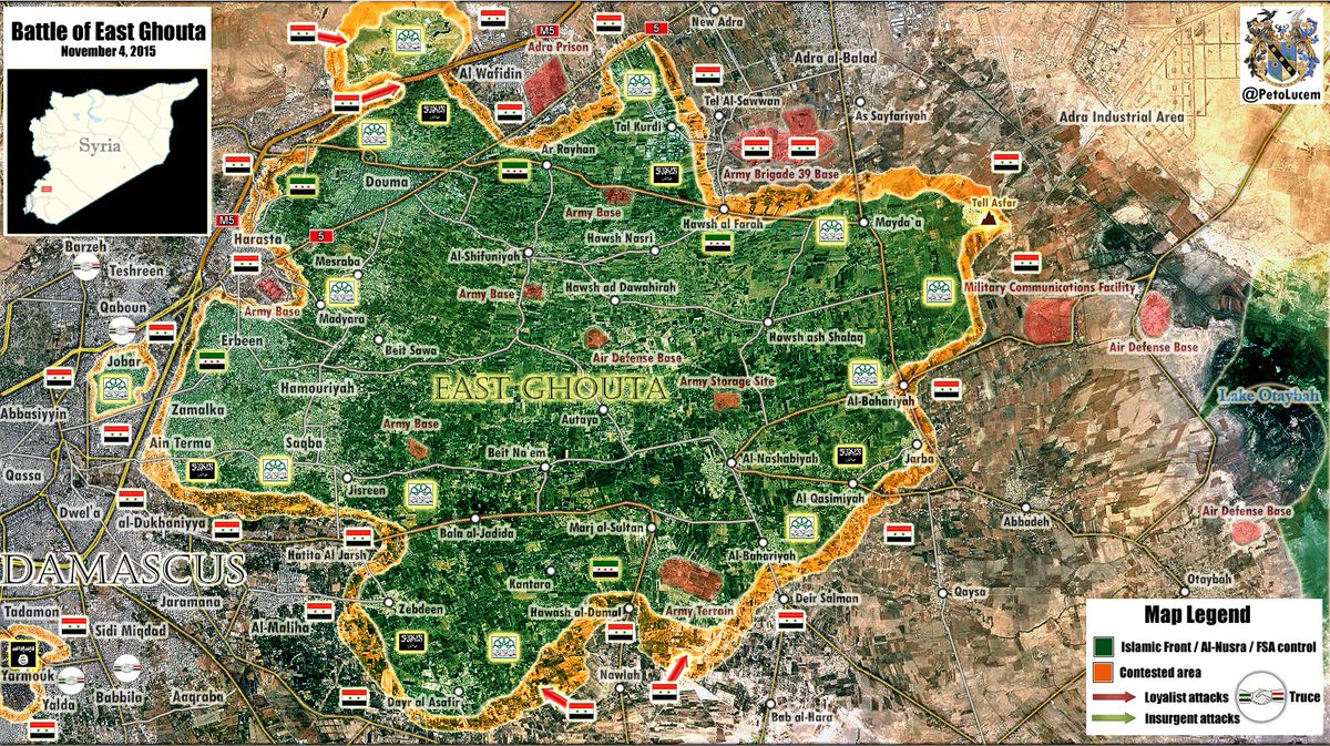
This battle map so out of date and should be updated...2.180.124.105 (talk) 14:28, 13 November 2015 (UTC)
- Situation is getting worse day by day. If things does not change we can consider removing it and going back to the old map. Advances to the Marj sultan base are not included and the control of all or most of the M1 highway from SAA is not included as well.Paolowalter (talk) 22:31, 14 November 2015 (UTC)
- To continue, the Aleppo one needs significant tweaking as well, they're vastly outdated. Who is the one editing them? MesmerMe (talk) 16:27, 13 November 2015 (UTC)
Al Eis controlled by the Army or contested ?
Peto Map from November 13 showing this place under Army control https://pbs.twimg.com/media/CTs_4ZXWIAACVzf.jpg:large — Preceding unsigned comment added by 200.84.36.197 (talk) 17:52, 13 November 2015 (UTC) http://www.almasdarnews.com/article/breaking-syrian-army-and-hezbollah-officially-capture-the-strategic-town-of-jabal-al-eiss-in-southern-aleppo/ — Preceding unsigned comment added by 200.84.36.197 (talk) 17:59, 13 November 2015 (UTC)
- Controlled: http://www.almasdarnews.com/article/syrian-army-and-hezbollah-capture-several-villages-in-southern-aleppo-en-route-to-cutting-off-the-m-5-highway/MesmerMe (talk) 18:02, 13 November 2015 (UTC)
- Prohibited Area is editing continuosly based on twitter or maps ofetn biased. I cannot revert all of them without breaking the 1RR rule. Please somebody should stop him.Paolowalter (talk) 18:04, 13 November 2015 (UTC)
- Al Eis under SAA.SOHRSOHRsourcesource Also all sources confirmed that th rebels also lost more territory to west, north and south from Al Eis they retreated to border with Idlib province.SOHRsourceSOHR 46.200.38.188 (talk) 21:23, 13 November 2015 (UTC)
- al-Eis is not the question,Icarda/Barqoum is the front now it should be contested.(looking at both sides reports)Totholio (talk) 21:45, 13 November 2015 (UTC)
- Al Eis under SAA.SOHRSOHRsourcesource Also all sources confirmed that th rebels also lost more territory to west, north and south from Al Eis they retreated to border with Idlib province.SOHRsourceSOHR 46.200.38.188 (talk) 21:23, 13 November 2015 (UTC)
- SOHR said that the SAA captured Barqoum.SOHR and SAA catured Icarda.SOHR. So this objects held-SAA but not contested. 46.200.38.188 (talk) 06:16, 14 November 2015 (UTC)
- I know but the front is at Barqoum now the orcs are trying to attack.Totholio (talk) 08:23, 14 November 2015 (UTC)
- Paolowalter (talk)I used a map to revert unreliable edits based in East Hasakah Governorate as approved by during a thread on the talks page. I have not used maps for any of other edits, as all others were reliable and detailed sourcesProhibited Area (talk) 12:22, 14 November 2015 (UTC)
- Prohibited Area but you have broken a rule of editing when you noted the town Al Eis as contested on based clear anti-SAA(pro FSA) source .here Despite the fact that more reliable sources including the SOHR confirm that the town controlled army. 46.200.38.188 (talk) 13:04, 14 November 2015 (UTC)
- The only sources saying Al-Eis was contested are twitter cause the frontline is far from Eis since days.Totholio (talk) 14:19, 14 November 2015 (UTC)
- Using any outside map as a source for edits, whether or not the edits are based on reliable sources or not, is against the rules for editing, Prohibited Area. You know this. If any edits are made that are not accurate, revert them, and provide a source justifying your edits. Using a map for your edits creates bias.DaJesuZ (talk) 00:07, 15 November 2015 (UTC)
- I only used a map after it was approved by other editors on the talk page. It was used as a reliable source to revert earlier unreliable edits; since this edit most of these villages have since been changed back to YPG-held in light of reliable sources detailing their control under the YPG. My edit on Al-Eis however, was inaccurate as it was a pro-rebel source and hence I apologise.Prohibited Area (talk) 10:37, 15 November 2015 (UTC)
- Using any outside map as a source for edits, whether or not the edits are based on reliable sources or not, is against the rules for editing, Prohibited Area. You know this. If any edits are made that are not accurate, revert them, and provide a source justifying your edits. Using a map for your edits creates bias.DaJesuZ (talk) 00:07, 15 November 2015 (UTC)
- Paolowalter (talk)I used a map to revert unreliable edits based in East Hasakah Governorate as approved by during a thread on the talks page. I have not used maps for any of other edits, as all others were reliable and detailed sourcesProhibited Area (talk) 12:22, 14 November 2015 (UTC)
- I know but the front is at Barqoum now the orcs are trying to attack.Totholio (talk) 08:23, 14 November 2015 (UTC)
Syrian Arab Army control Handarat Town in Northern Aleppo.
This was reported on with a source a few months back, however it was decided that the source was not reliable at the time: but here in a pro government source it states ."......Syrian Government held town of Handarat and east of the rebel stronghold of Haritan;......" Source: [19] http://www.almasdarnews.com/article/breaking-syrian-army-and-hezbollah-launch-fresh-offensive-in-northern-aleppo/ — Preceding unsigned comment added by 213.94.232.159 (talk) 23:07, 14 November 2015 (UTC)
- I remember this coming up sometime ago, but because there is a city named Handarat as well, as well as a Handarat camp, we assumed they were referring to the camp. al-Masdar, by that time, was being used as a reliable source, but the claim that city of Handarat was controlled by regime forces was made by SyrianObserver2015. We haven't seen anything explicitly stating that the city is under government control.DaJesuZ (talk) 00:11, 15 November 2015 (UTC)
- Handarat it is a village which under control of SAA and located to south of also SAA-held village Sayfat. This villages marked as under SAA on this map Rif Aleppo2 So don't need add this village on our map. 178.95.150.71 (talk) 12:07, 15 November 2015 (UTC)
Wikipedia Syrian Civil War map
This map should really be deleted. It was reliable and stable 4 months ago but now became a place for 15 year old trolls and a place for shitposts. I don't have to mention that the map has 200 mistakes. Admin left this article months ago, they basically gave up, so I'm not sure why does this still exist. 109.175.58.213 (talk) 19:25, 14 November 2015 (UTC)
- You should be deleted from here. This is the best map, 10x better than any big media outlet's map or professional analysts. You are 99% a nusra supporter.Totholio (talk) 11:39, 15 November 2015 (UTC)
- And what 200 mistakes would that be?MesmerMe (talk) 21:04, 14 November 2015 (UTC)
- Yes, I would like to know it too. This map is my primary source of information and is always in line with other reliable sources. What I see is a lot of people carefully sifting through the news every day and updating the map. The only troll I see is the person who started this thread. --109.60.42.98 (talk) 21:22, 14 November 2015 (UTC)
If somebody is not happy with this map, he can use an alternative map and just leave this map to whom trust this map. In addition, I believe that this map is the best and most reliable and most lucid and most up-to-date map im whole internet. --2003:6A:6740:5E82:581C:8E48:8BBF:FF54 (talk) 20:20, 15 November 2015 (UTC)MapMaker
M1 road in Damascus map
I think the Army controlled all or mosts sectors from M1 Road near Douma in Damascus map
These are lasted maps from that November 4 and 5 2015 https://pbs.twimg.com/media/CS_ZexIWEAA-5P1.jpg https://pbs.twimg.com/media/CTEV4RIWwAA8h-0.jpg
The first source is very credible. — Preceding unsigned comment added by 200.84.36.197 (talk) 16:06, 14 November 2015 (UTC)
- I agreed that this is very likely, but we need better sources. MesmerMe (talk) 16:13, 14 November 2015 (UTC)
Peto map proved his credibility are very good his map always are 99,99% rights . — Preceding unsigned comment added by 200.84.36.197 (talk) 18:57, 14 November 2015 (UTC)
- That's not the point, we cannot use his maps a source MesmerMe (talk) 21:03, 14 November 2015 (UTC)
The source is good common... — Preceding unsigned comment added by 200.84.36.197 (talk) 23:20, 14 November 2015 (UTC)
- Maps cannot be used as sources. Provide something better to use for an edit.DaJesuZ (talk) 00:12, 15 November 2015 (UTC)
Now, however, we can edit. Source.MesmerMe (talk) 09:02, 16 November 2015 (UTC)
Al-Hawl is under YPG control
Who changed back village of Nazila, between Hasaka and al-Hawl to black? This village and its surrounding has captured by YPG since a week ago. since for example this ANHA (of course pro-YPg) cameraman interviewing the local villagers: http://www.hawarnews.com/%D8%A3%D9%87%D8%A7%D9%84%D9%8A-%D9%82%D8%B1%D9%8A%D8%A9-%D8%A7%D9%84%D9%86%D8%B2%D9%8A%D9%84%D8%A7-%D9%8A%D8%B4%D9%83%D8%B1%D9%88%D9%86-%D9%82%D9%88%D8%A7%D8%AA-%D8%B3%D9%88%D8%B1%D9%8A%D8%A7-%D8%A7/ Same is true for Masudiyah and Um Hujra north of al Hawl. These villages were among the first ones which fell to YPG. Roboskiye (talk) 14:54, 14 November 2015 (UTC)
- The village of Um Hujaira (wrongly labelled as Abu Hujaira on this map) captured today by YPG. It is 5 km northwest of Al Hawl and 12 km west of Khatuniyah. See ANHA report and the visual evidence provided in the link: http://www.hawarnews.com/%D9%82%D8%B1%D9%8A%D8%A9-%D8%A3%D9%85-%D8%AD%D8%AC%D9%8A%D8%B1%D8%A9-%D9%85%D8%AD%D8%B1%D8%B1%D8%A9%D8%8C-%D9%88%D8%A7%D9%84%D9%85%D8%B1%D8%AA%D8%B2%D9%82%D8%A9-%D9%81%D8%B1%D9%88%D8%A7-%D9%85%D9%86/#prettyPhoto See even the road sign: http://hawarnews.com/wp-content/uploads/2015/11/2015-11-16.HSK_.DIMENEN.GUNDE_.UM-_72075262_-__.jpg Roboskiye (talk) 21:12, 15 November 2015 (UTC)
- And here is visual evidence for Al-Hawl Grain Silos: http://hawarnews.com/%D9%85%D8%B1%D9%83%D8%B2-%D8%AD%D8%A8%D9%88%D8%A8-%D8%A7%D9%84%D9%87%D9%88%D9%84-%D8%A8%D8%B9%D8%AF-%D8%AA%D8%AD%D8%B1%D9%8A%D8%B1%D9%87/#prettyPhoto So we change village of Um Hujaira and al-Hawl Grain Silos according to the evidence. Roboskiye (talk) 10:30, 16 November 2015 (UTC)
Karkiz
SAA captures Karkiz southern Kuwaires --212.75.52.4 (talk) 10:43, 16 November 2015 (UTC)MapMaker
- Source: http://www.almasdarnews.com/article/kuweires-military-airport-officially-secure-as-the-syrian-army-captures-kaskays-village/MesmerMe (talk) 11:02, 16 November 2015 (UTC)
- SOHR also reported that the SAA captured village Karkiz to south of Kweiris Airbase.SOHR 95.135.205.133 (talk) 11:15, 16 November 2015 (UTC)
Dayr Hanna
Dayr Hanna seems to be contested. http://www.almasdarnews.com/article/breaking-syrian-army-enters-deir-hanna-in-northern-latakia/ MesmerMe (talk) 09:06, 16 November 2015 (UTC)
- SOHR reported that the SAA advance around the village of Ghamam and captured hill.SOHR So need removed green semicircle near Ghamam. 95.135.205.133 (talk) 11:21, 16 November 2015 (UTC)
SAA captured Deir Hanna village / Latakia (2 hours ago ?) --212.75.52.4 (talk) 13:05, 16 November 2015 (UTC)MapMaker
- Seems like it, but needs confirmation. MesmerMe (talk) 13:09, 16 November 2015 (UTC)
Latest from Al Masdar is more towns taken i can not find them on map .86.135.155.101 (talk) 19:40, 16 November 2015 (UTC)
Al Mutilla is Daghmashllay according to wikimapia .86.135.155.101 (talk) 20:01, 16 November 2015 (UTC)
Tall Syria Tel
Breaking :SAA imposed fire control on SyriaTel hill ( just westside of Tadmur) (?) --212.75.52.4 (talk) 12:43, 16 November 2015 (UTC)MapMaker
- Fire control means they can target it by thier fire, not that they control it. Helmy1453 (talk) 16:45, 16 November 2015 (UTC)
- Regarding the Palmyra front, why were a lot of SAA held positions reverted about a months ago? MesmerMe (talk) 12:52, 16 November 2015 (UTC)
- Several Pro-SAA sources (including Al-Masdar) reported, that SAA was not closer than 10km to Palmyra. Schluppo (talk) 13:30, 16 November 2015 (UTC)
- Thank you, I didn't notice the reporting. MesmerMe (talk) 14:32, 16 November 2015 (UTC)
- SAA/allies captured the Tal Syriatel and Jabal Ma’ar, Al-Bayarat the Ancient Palmyra Quarries, Al-Kassarat and Al-Dawa outside the city of Palmyra after a series of intense firefights with ISIS.source 95.134.186.238 (talk) 14:40, 17 November 2015 (UTC)
- Thank you, I didn't notice the reporting. MesmerMe (talk) 14:32, 16 November 2015 (UTC)
- Several Pro-SAA sources (including Al-Masdar) reported, that SAA was not closer than 10km to Palmyra. Schluppo (talk) 13:30, 16 November 2015 (UTC)
Ayn Issa
Opposition source reported that fierce clashes now in the surrounding of town Ayn Issa between ISIS and YPG and that ISIS advancement toward the town and YPG retreated toward Ayn Issa.sourcesource 37.52.29.111 (talk) 09:41, 17 November 2015 (UTC)
Two unidentified Facebook posts? Are those sources? No, those are meaningless posts of an unknown author. We don't use those sources on this map.
- Social media is generally not allowed as a source, however,an exception CAN be made if there is a general consensus among the editors of the map. The only exception to this rule is Twitter. It is unfathomably rare that we use that as a source. DaJesuZ (talk) 02:38, 18 November 2015 (UTC)
Al Zerbah
town of Al Zerbah under control by rebel groups.SOHR and SAA attempts to advance towards this town. 95.134.186.238 (talk) 11:01, 18 November 2015 (UTC)
- Added, also arc representing SAA attackAriskar (talk) 11:52, 18 November 2015 (UTC)
121st Artillery Regiment near Hasakah
Several opposition sources confirmed that YPG has captured the Eastern half of the Military Base of the 121st Artillery Regiment near Hasakah after heavy clashes with ISIS.herehereherehere also neutral source reported about clashes between SDF and ISIS at regiment 121 in Hasaka that ISIS take from the government forces in the July 2014.here 95.134.186.238 (talk) 18:03, 17 November 2015 (UTC)
- Facebook and Twitter do not help. We need reliable sources. Schluppo (talk) 22:48, 17 November 2015 (UTC)
I´m not changing anything, but I do think it´s fair to say it´s contested.Rhocagil (talk) 23:14, 17 November 2015 (UTC)
- Facebook can be used as a source if there is a general consensus among editors. Twitter hasn't been used to change anything on the map for quite some time, and is almost always ignored as a source.
- The area will not be shown as contested.DaJesuZ (talk) 02:39, 18 November 2015 (UTC)
- But there's no consensus (thank God) about using Facebook, Twitter, Reddit or other untrustable social media, as they are 90% of the times highly unreliable sources. By the way, Im removing dozens of links based on social media, in order to adhere to Wikipedia editing policy. Im so fed up of trolls using that shitty social media as they were reliable sources, in order to made their POV-pushing look backed by something.--HCPUNXKID 19:50, 18 November 2015 (UTC)
ISIS launch counter-attack south of Al-Hawl?
Opposition source [Local Coordination Committees of Syria] reported that the ISIS retake two villages in the south of town Al Hawl and targeted the town with missiles.here 95.134.186.238 (talk) 15:01, 19 November 2015 (UTC)
Huwayr al-Eis
I think we can add on map the village Huwayr al-Eis to south from SAA-held village the Tell Bajer as under control the rebels because the SOHR reported about clashes between SAA and the Islamic fighters and Al-Nusra in this area and that Russian Air Force made several strikes of this village.SOHR 95.134.186.238 (talk) 13:53, 19 November 2015 (UTC)
- Agreed, this town should be added with a red hafcircle at the northern side.MesmerMe (talk) 17:04, 19 November 2015 (UTC)
Lattakia
There is this source AlMasdar that, beside reporting the taking of the Zuwayk peak, reports two more peaks Point 482 and Point 1112 and that SAA reached Ghanimah (without taking it). Is this place Ghunaymiyah [20]? If so, SAA has moved quite north and some other locations further south could go red.Paolowalter (talk) 18:41, 19 November 2015 (UTC)
- A red half circle seems appropiate on the Southern outskirts of Ghunaymiyah. It therefore seems that this area is SAA held, I.E. red. http://wikimapia.org/#lang=en&lat=35.706238&lon=36.047516&z=14&m=b&gz=0;360292768;356883240;858;145684;0;141502;60939;0;68664;4182;747585;57161;724411;197957;613689;234894;613689;234894;341606;233500;221443;216077;6866;154745 MesmerMe (talk) 19:46, 19 November 2015 (UTC)
- MesmerMe Opposition source also confirmed that the SAA advancing towards village Qasab and that they captured all villages between Ghamam and Qasab.herehere 37.53.190.60 (talk) 21:00, 19 November 2015 (UTC)
- MesmerMe Also village Zuwayk has been added on the maphere as under control of SAA.[www.almasdarnews.com/article/syrian-army-lasites-captured/ source] but this village earlier was marked on map as Al Mutilah but this wrong. No village Mutilah in this area only Zuwayk. So need removed Al Mutilah and leave only Zuwayk.hereherehere You can do this? 37.53.190.60 (talk) 21:06, 19 November 2015 (UTC)
- MesmerMe Opposition source also confirmed that the SAA advancing towards village Qasab and that they captured all villages between Ghamam and Qasab.herehere 37.53.190.60 (talk) 21:00, 19 November 2015 (UTC)
- Also SAA captured:
- Bayt ‘Ayyashsource
- DughmashliyahSOHRsource
- Al-RashwanSOHRAl Masdar 37.53.190.60 (talk) 21:19, 19 November 2015 (UTC)
This pretty much confirms all SAA movement. I further put a red halfcircle south of Qasab, as the reporting indicates, and some other kind editor changed the name of the town already. MesmerMe (talk) 21:36, 19 November 2015 (UTC)
ICARDA base, south of Aleppo
This place was turned red some days ago by Prohibited Area using [21] as source. However, tweets and maps are in general not reliable sources and indeed, there are reports that the rebels still control ICARDA base, that (Russian) Airforce is bombing the base and that SAA is currently preparing to attack it. I found no reliable source claiming that SAA/shiite militias already took ICARDA base. Summing up, I think Prohibited Area's edit should be reverted unless there is a reliable source supporting it. Schluppo (talk) 17:47, 16 November 2015 (UTC)
- If you have a pro-gov source claiming ICARDA based is under SAA or Russian attack that would be satisfactory to revert edit. I do not have a source as such however.Prohibited Area (talk) 18:13, 16 November 2015 (UTC)
- The edit was based on a map from twitter, i.e. strongly violating the rules in the first place. Why would we need a source to revert it? Anyway, I found a reliable source (SOHR, yesterday) stating that SAA etc. took control of "ICARDA project near Kweires airbase" [22], which presumably refers to [23]. So it should stay red anyway. Schluppo (talk) 19:27, 16 November 2015 (UTC)
- Don't lie, Al masdar and pro opposition reported ICARDA taken, even SOHR, read back. Also this is not that ICARDA you are talking about. By the way pro SAA sources are arguing that SAA only got fire control on ICARDA cause after taking it they might retreated, it is in the open field so it would be understandable.Totholio (talk) 20:48, 16 November 2015 (UTC)
- The edit was based on a map from twitter, i.e. strongly violating the rules in the first place. Why would we need a source to revert it? Anyway, I found a reliable source (SOHR, yesterday) stating that SAA etc. took control of "ICARDA project near Kweires airbase" [22], which presumably refers to [23]. So it should stay red anyway. Schluppo (talk) 19:27, 16 November 2015 (UTC)
There are 2 ICARDAs. One north Kuwairas, One on M5 road south-west Aleppo. The one in north in full SAA control and the one in west, only partly under SAA, while they 'clean' this vast area.2003:6A:6740:5E82:581C:8E48:8BBF:FF54 (talk) 20:39, 16 November 2015 (UTC)MapMaker
- A map was not used to edit the source therefore the rule on not copying from maps was not violated. Upon reviewing the source the neutrality is questionable.Prohibited Area (talk) 20:40, 16 November 2015 (UTC)
- Alright, sorry. So there are two ICARDAs. Here is a reliable source (SOHR, 2015-11-13) stating "amid advancement for the regime forces and seizing al- Ikarda area which is adjacent to Aleppo – Damascus international highway" [24]. Also, please don't accuse me of lying, I was merely critizing the edit that was based on a Peto-Lucem tweet and asking for a reliable source on the matter. Schluppo (talk) 22:25, 16 November 2015 (UTC)
- Hey guys SOHR clear said that the regime forces(SAA) advanced and seized al- Ikarda area which is adjacent to Aleppo – Damascus international highway.SOHRSOHR 37.52.29.111 (talk) 08:50, 17 November 2015 (UTC)
- I'm sorry Schluppo, you sounded like a troll. There's heavy fighting, like I said Icarda on the highway is most likely contested now.Both sides are gathering forces.Totholio (talk) 11:03, 17 November 2015 (UTC)
- Totholio ICARDA area near the highway but not on highway and we marked as under control SAA only ICARDA Army base which is located at a distance of over a kilometer from the highway. 95.134.186.238 (talk) 14:34, 17 November 2015 (UTC)
- I know a military base won't be on a highway... I was trying to distinguish it from the one near Kweiris. I know it was fully captured by SAA, I'm just saying SAA sources are arguing that it's only under fire control cause they might withdrew from it,it's in the middle of an open field, easy target, not like the hills east of it.Totholio (talk) 15:35, 17 November 2015 (UTC)
- Totholio ICARDA area near the highway but not on highway and we marked as under control SAA only ICARDA Army base which is located at a distance of over a kilometer from the highway. 95.134.186.238 (talk) 14:34, 17 November 2015 (UTC)
- I'm sorry Schluppo, you sounded like a troll. There's heavy fighting, like I said Icarda on the highway is most likely contested now.Both sides are gathering forces.Totholio (talk) 11:03, 17 November 2015 (UTC)
- Hey guys SOHR clear said that the regime forces(SAA) advanced and seized al- Ikarda area which is adjacent to Aleppo – Damascus international highway.SOHRSOHR 37.52.29.111 (talk) 08:50, 17 November 2015 (UTC)
- Totholio Near Kweiris it was not a army base it was the ICARDA Farms. But to south of Aleppo it is a army base. 95.134.186.238 (talk) 18:07, 17 November 2015 (UTC)
- And? Someone just changed both ICARDA and Tel Hadiya to the orcs.Totholio (talk) 21:18, 17 November 2015 (UTC)
- Totholio But SOHR not said that ICARDA and Tall Hadiya under rebels and Al-Barqoum contested. SOHR only said that rebels destroy SAA tank on outskirts Tall Hadiya.SOHR Also SOHR said that the clashes are taking place in the vicinity of town Zorba in the southern countryside of Aleppo between SAA against the rebel in an attempt by the SAA to advance towards the town of Al Zorba.SOHR 95.134.186.238 (talk) 21:23, 17 November 2015 (UTC)
- That's what I'm saying, Tel Hadiya is clearly under SAA/allies.Totholio (talk) 21:36, 17 November 2015 (UTC)
- Totholio But SOHR not said that ICARDA and Tall Hadiya under rebels and Al-Barqoum contested. SOHR only said that rebels destroy SAA tank on outskirts Tall Hadiya.SOHR Also SOHR said that the clashes are taking place in the vicinity of town Zorba in the southern countryside of Aleppo between SAA against the rebel in an attempt by the SAA to advance towards the town of Al Zorba.SOHR 95.134.186.238 (talk) 21:23, 17 November 2015 (UTC)
- And? Someone just changed both ICARDA and Tel Hadiya to the orcs.Totholio (talk) 21:18, 17 November 2015 (UTC)
Yes it's clearly under gov. control. Is this a joke ? Now even SOHR is listed as an unreliable source. I agree that the map should be just deleted, it makes no sense. This is now not a wikipedia article but a forum where everybody thinks it's his own right to decide what or what not should be changed. No admins are present on this article. DuckZz (talk) 22:39, 17 November 2015 (UTC)
- DuckZz I agree that this map is a war itself but I still do believe that this map is the best representation of the reality (thou not ever being 100% accurate). What map if not this one? So please just keep fighting the fight your are fighting right now, I know you are one of the good ones! Rhocagil (talk) 23:22, 17 November 2015 (UTC)
- SOHR reliable source but he is not said that the ICARDA and Tall Hadiya under rebels and Al-Barqoum contested. 95.134.186.238 (talk) 06:44, 18 November 2015 (UTC)
- What's your problem duckz? you are posting a knows jihadist supporters twitter with 2 random pictures? Seriously? Sohr a pro orc source claims tow hit on Tal hadiya, what you think who controls it then? Not a single pro opp source claimed icarda and hadiya under their control sohr would've done it in 2 minutes. It's most likely contested if SAA is already at Barqoum.Totholio (talk) 07:38, 18 November 2015 (UTC)
- SOHR reliable source but he is not said that the ICARDA and Tall Hadiya under rebels and Al-Barqoum contested. 95.134.186.238 (talk) 06:44, 18 November 2015 (UTC)
- Rebels recaptured Banis farms near the village of Banis.(pro FSA)sourceSOHRAl Masdar 95.134.186.238 (talk) 08:49, 18 November 2015 (UTC)
- Bani farms are south of Banis village, currently accurately represented by a lime south arc to the Banis village.Ariskar (talk) 11:51, 18 November 2015 (UTC)
Of course we can not use the following, since it is a) a map and b) pro-opposition. But it at least shows the claims of pro-opposition side: [25]. Notice that reliable sources reported that SAA took Hamraa and Khalasah yesterday, so this pro-opposition map is most probably incorrect there. Other deviations: Pro-opposition map shows Rasm Sahrij, Tal Hadiyah, ICARDA, al-Barqoum, Tel-Eiz (west of al-Eis) and Sa'ibiyah under rebel control. It appears to me, that it might be the case that SAA initially captured the mentioned locations west of al-Eis some days ago and retreated at this front in the meantime. Of course this is just speculation without proper sources. So, in the interest of being objective, we should look out for any reliable sources talking about these locations. Schluppo (talk) 19:29, 18 November 2015 (UTC)
![[25]](http://www.mediafire.com/convkey/1a37/fs6nya2116lbvlmzg.jpg)
- Relaible source confirmed that the SAA advance toward Al-Zerbah to north from al-Barqoum.[26] SOHR
- Also map from another pro opposition source showed that the Rasm Sahrij under SAA.here But we can edit map only based data from relaible sources(not on based of amateur maps or data from twitter). SOHR clear said that SAA captured Barqoum,ICARDA base and Rasm Sahrij but not said that SAA retreated or that the rebels retake these objects. So that lets we will wait more data from relaible sources. 95.134.186.238 (talk) 19:54, 18 November 2015 (UTC)
- But I agree that the Sa'ibiyah under rebel control because not a one from the reliable sources not said that SAA captured this village. Also pro-SAA map(for 13 Nowember) from Petro showed that this village rebel-held.[27] 95.134.186.238 (talk) 20:05, 18 November 2015 (UTC)
- One more unreliable source that cannot be used, but still gives some background knowledge: This [28] appears to be today, rebels, looking in this angle [29] from eastern perimeters of Tell Hadiya (somewhere around here [30]), towards Jabal Al-Eis (army fueling base [31] is at the foot of the hill that is visible in the first 10 seconds of the video, El-Eis [32] can be seen on the right slope of this hill). The tower at 0:30 in the video is here [33]; it can also be seen from far at 0:40 in the video. I would say that this is quite convincing (indicating, that Tell Hadiya is under rebel control), however, we still have to wait for reliable sources talking about this area. Schluppo (talk) 22:40, 19 November 2015 (UTC)
IS in Kafr Hamra?
That's what SOHR states, but that looks strange if we look to our map, as IS is suppossedly km. away east of that town. So there's only 3 options:
- SOHR is wrong (one more time).
- Our map is wrong.
- IS can infiltrate the insurgent side and attack them later.
--HCPUNXKID 19:59, 18 November 2015 (UTC)
fourth option: a group of insurgents has defected from their parent organization and pledged allegiance to IS. --AliMD7176 (talk) 21:33, 18 November 2015 (UTC)
- This is quite interesting. I would suggest that we get a second source to confirm such news.188.25.120.247 (talk) 23:28, 18 November 2015 (UTC)
- In the arabic version the same is mentioned. But no confirmations by any other source... I did even not find any tweets about it. So either it is a mistake by SOHR or the fightings are related to the assasination mentioned in the same article, so that we could suppose some ISIS cells (or a small defected group of insurgents) in Kafr Hamra. Mughira1395 (talk) 09:36, 19 November 2015 (UTC)
- Tweets are not sources. Do not treat them as such, Mughira1395. DaJesuZ (talk) 03:57, 20 November 2015 (UTC)
Map with Roads and Highways Ready
Following the news about civil war in Irak and Syria, we hear about important roads and Highwys. But we don't see them on the maps to get better oriented. Please someone add roads and highways also to the maps. Thanks! -> In Persian:
با دنبال کردن خبر ها در باره ی جنگ درونمرزی در عراق و سوریه و .. ما همواره چیزهایی در باره ی راه ها و شاهراه های مهم میخوانیم ولی آنهارا در نقشه پیدا نمیکنیم و نمیتوانیم جا های یاد شده را بهتر بیابیم. پس خواهشمندم که راه ها و شاهراه هارا هم به این نقشه ها بیفزایید. سپاس. — Preceding unsigned comment added by 212.75.52.4 (talk) 11:57, 28 October 2015 (UTC)
- Good idea, I was thinking of the same, especially knowing situation near Ithriya. We can add them just the same as other background maps, but these should be simpler, with just lines. --Hogg 22 (talk) 12:01, 28 October 2015 (UTC)
- Who can do this? Who manages the background map? — Preceding unsigned comment added by 212.75.52.4 (talk) 15:38, 28 October 2015 (UTC)
- Wouldn't the addition of roads and major highways require a changing of the background image for the template? I'm pretty ignorant when it comes to this, but I don't know of any way to add the roads without a changing of the .png image used in the background, besides, what colour would we make them? Black would be too close to IS's dot colour, similarly, grey would be too close to al-Nusra's. DaJesuZ (talk) 14:06, 29 October 2015 (UTC)
- I dont know if a new layer can provide the roads or rather changing the backgroud map. But what concerns the color of highways, it is often yellow-orange with thin red borders on each side like here : Damascus Road Map . The roads colors must be kept neutral to civil war parties. we can see then from rectangle-dots ( f.e. IS presence on Ithariya road ) , who controls the road part at any time. — Preceding unsigned comment added by 212.75.52.4 (talk) 08:32, 30 October 2015 (UTC)
I made a Map with Roads and Highways on base of the existent map. Here it is in png format:SyriaRoadsMap Can somebody who has the autority, replace the old one with this? — Preceding unsigned comment added by 212.75.52.4 (talk) 13:04, 30 October 2015 (UTC)
- That looks absolutely awesome! 84.212.61.74 (talk) 13:08, 30 October 2015 (UTC)
- Great efforet thatnk you. I don't know how to replace the original one with th is though :( Helmy1453 (talk) 14:08, 30 October 2015 (UTC)
- Thank you very much for your work! I have a question for you. The original file (Syria location map3.svg) is in .SVG format. Can you save your file in .SVG format? What will happen is that your file will have to be uploaded in Wikimedia Commons (https://commons.wikimedia.org/wiki/File:Syria_location_map3.svg) as "a new version of file" Syria location map3.svg Then everything should work automatically. By the way, User:Spesh531 is the one who has updated this file the most lately. Also, there is another thing. The Highways need to be much thinner. They are now too intrusive. The red border can be removed and the orange line made a lot thinner. It should be thick enough to distinguish them from other roads, but not more. Maybe just double the thickness of the other road lines. Tradediatalk 11:05, 31 October 2015 (UTC)
- I will modify the map as requested as soon as possible. — Preceding unsigned comment added by 2003:6A:6740:5E82:5138:4B24:66B0:26C3 (talk) 18:07, 1 November 2015 (UTC)
- I made the Highways much thinner now, but I have no possibility to chenge my PNG file to Vector file SVG . But As I see, there is no obligation to use a SVG file, because the dimentions don't change in all browsers. But if anyone can make a SVG -format file out of this, please go ahead. Here is the new map in PNG -format.Syria Road Map With Thinner Highways — Preceding unsigned comment added by 2003:6A:6740:5E82:651B:C436:1C10:7C82 (talk) 20:41, 1 November 2015 (UTC)
- Ok, so I went ahead and uploaded your PNG file as a new file (File:Syria location map4.png) to be used as a template for Syria maps. If someone has a problem with it being a new PNG file instead of the previous SVG file then they can do what they need to do... By the way, I have personally claimed copyright of the file & allowed it to be freely distributed. If this is a problem for you then please let me know (I am not sure if the copyright can be attributed to an anonymous IP as opposed to a user name account...) The new Highways look great. However, there seems to be a mistake in the al-Ithriyah-Khanasir road. According to wikimapia, the road goes through Khanasir. However, on our map, the road does not go through Khanasir, but rather to the east of it. I verified the coordinates of Khanasir on our map, and found it is correct (lat = "35.782", long = "37.499"). By the way, I make a call to all viewers (& editors) of the map to look for mistakes in the highways & roads (and post them in this section) so that we can find them & iron them out once and for all. Again, thank you very much user IP 212/2003 for your contribution. This was long overdue. Tradediatalk 05:12, 2 November 2015 (UTC)
- Thank you very much applying my map. I know , there can be some minor deviations ( so I hope) from real road locations. But now we have a background-Basis-road-map and everybody who can work with a Paint-application, can correct those devations which are in important front lines.
- Ok, so I went ahead and uploaded your PNG file as a new file (File:Syria location map4.png) to be used as a template for Syria maps. If someone has a problem with it being a new PNG file instead of the previous SVG file then they can do what they need to do... By the way, I have personally claimed copyright of the file & allowed it to be freely distributed. If this is a problem for you then please let me know (I am not sure if the copyright can be attributed to an anonymous IP as opposed to a user name account...) The new Highways look great. However, there seems to be a mistake in the al-Ithriyah-Khanasir road. According to wikimapia, the road goes through Khanasir. However, on our map, the road does not go through Khanasir, but rather to the east of it. I verified the coordinates of Khanasir on our map, and found it is correct (lat = "35.782", long = "37.499"). By the way, I make a call to all viewers (& editors) of the map to look for mistakes in the highways & roads (and post them in this section) so that we can find them & iron them out once and for all. Again, thank you very much user IP 212/2003 for your contribution. This was long overdue. Tradediatalk 05:12, 2 November 2015 (UTC)
- I modified tha map to correct the road near Khanasir and added some road-numbers for better orientation with the news. here it is:correction #1 and some road numbers — Preceding unsigned comment added by 212.75.52.4 (talk) 11:15, 2 November 2015 (UTC)
- Actually we do not need the road-numbers. They are too intrusive and the media do not mention road numbers much. For example, I don't recall the media mentioning that the Salamiyah-Ithriyah road is number 42. Tradediatalk 11:55, 2 November 2015 (UTC)
- OK, This one is without road numbers :roads without numbers — Preceding unsigned comment added by 212.75.52.4 (talk) 12:25, 2 November 2015 (UTC)
- Thank you very much. Correction uploaded! Tradediatalk 14:43, 2 November 2015 (UTC)
- OK, This one is without road numbers :roads without numbers — Preceding unsigned comment added by 212.75.52.4 (talk) 12:25, 2 November 2015 (UTC)
- Actually we do not need the road-numbers. They are too intrusive and the media do not mention road numbers much. For example, I don't recall the media mentioning that the Salamiyah-Ithriyah road is number 42. Tradediatalk 11:55, 2 November 2015 (UTC)
- I modified tha map to correct the road near Khanasir and added some road-numbers for better orientation with the news. here it is:correction #1 and some road numbers — Preceding unsigned comment added by 212.75.52.4 (talk) 11:15, 2 November 2015 (UTC)
Hey i noticed that the road between manbij to raqqah via tishrin dam was missing, its a pretty important road, as its the shortest route between manbij and raqqah for IS. if you guys could find the time to add it, it would be a great addition, i dont know how to add the roads, else i would attempt it myself. Midgetman433 (talk) 15:45, 2 November 2015 (UTC)
- Thank you for your participation. I will wait maybe 2 days for some other change requests and then I will fulfill them all together. 2003:6A:6740:5E82:5138:4B24:66B0:26C3 (talk) 18:37, 2 November 2015 (UTC) MapMaker
This was really good work! thanks to all that contributed!Rhocagil (talk) 17:30, 2 November 2015 (UTC)
- I reverted the change of the global Syria map definition from SVG to PNG. Either add the roads to an SVG version of the map (preferably), or specify the PNG as an AlternativeMap in the module. Re the IP, if you use Inkscape instead of MS Paint (or whatever it is you're using), it'll let you edit and save SVGs. Jackmcbarn (talk) 19:02, 2 November 2015 (UTC)
- Fair enough. I figured out a different way that does not use the global module. There was already a map in use as an AlternativeMap in the global module and it is in use on many articles. Tradediatalk 03:19, 3 November 2015 (UTC)
- @Tradedia: You actually had AlternativeMap and image1 mixed up. In any case, it's sorted out now, and it's now using just the original definition (not the Syriawar one) but still using the right map. Jackmcbarn (talk) 22:35, 3 November 2015 (UTC)
- @Jackmcbarn: Ok, I see what you mean now. Thanks. Tradediatalk 23:17, 3 November 2015 (UTC)
- @Tradedia: You actually had AlternativeMap and image1 mixed up. In any case, it's sorted out now, and it's now using just the original definition (not the Syriawar one) but still using the right map. Jackmcbarn (talk) 22:35, 3 November 2015 (UTC)
- Fair enough. I figured out a different way that does not use the global module. There was already a map in use as an AlternativeMap in the global module and it is in use on many articles. Tradediatalk 03:19, 3 November 2015 (UTC)
Thanks for your work. But the roads near Ghamam in Latakia are not in the correct position. See [34]. Schluppo (talk) 10:57, 3 November 2015 (UTC)
- Same holds for the Jisr-al-Shugour area; streets are quite bugged there: e.g. Bishlaymun [35] sits a few kilometers north of the highway. On the new map with roads, it is directly on the highway. etc. I fear it is going to take some serious effort to add all these minor corrections to the position of roads in all the places where it is necessary. Cheers, Schluppo (talk) 11:17, 3 November 2015 (UTC)
- OK, I modified the roadmap : 1- Added Road Manjib to Al-Raqqa via Tishrin dam + 2- Highway Lakatia-Jisr al Shoghur corrected (Ghammam) . Here the modified file : Syria Roads Correction 2 . 212.75.52.4 (talk) 11:52, 3 November 2015 (UTC)MapMaker
- Thanks. New version uploaded! Tradediatalk 23:17, 3 November 2015 (UTC)
Hello, thanks for the great work with the roads, it is extremely helpful. But, could you correct the one road that goes throgh Southern Aleppo? It actually extends from Tall Daman through Burida, Kafr Abid and Blas to Sheik Said and doesnt go through al-Manatir. Thanks in advance. Oberschlesien1990 (talk) 14:28, 4 November 2015 (UTC)
- Thank you for your participation. I will wait maybe 2 days for some other change requests and then I will fulfill them all together. --212.75.52.4 (talk) 15:46, 4 November 2015 (UTC)MapMaker
New modified roads map: Here is the Road Map Syria Correction 3. I corrected the road from Tall Daman to Aleppo (Sheikh Sa'id) + the Highway from Jisr-Al-Shoghur to Ariha. --212.75.52.4 (talk) 12:03, 5 November 2015 (UTC)MapMaker
- Thanks. New version uploaded! Tradediatalk 12:48, 5 November 2015 (UTC)
Hey could you add the al hawl road that connects the syria/iraq road to al hawl and road that connects al hawl to hasakah, it is a very important road b/c this the pathway IS uses to push further into cizire canton and the hasakah countryside, it would do a better job as to explaining the strategic importance of al-hawl and why the ypg has launched a huge offensive to capture al-hawl. b/c without the road al hawl just looks like a town in the middle of a desert, and the observer cannot understand its strategic importance. here is the road displayed on wikimapia for reference: http://wikimapia.org/#lang=en&lat=36.387018&lon=41.060715&z=11&m=b Midgetman433 (talk) 14:54, 12 November 2015 (UTC)
Here is the modified Syria roads map (Road Map Syria Correction 4) with:
1- Al-Hawl road to Hasaka and to border
2- ICRADA at the right side of Highway
3- Road from Uqayribat to Tadmur via al-Mushayrifah
4- Ain_Issa to Al-Qantari Road
--212.75.52.4 (talk) 10:13, 13 November 2015 (UTC)MapMaker
Hey could you add the road between hasakah and a town close to Raqqah called fatsat ath Thayb, the town isnt on the syrian civil war map(if you know how to add towns, could you add it also please), but it is close to hamrat balasin, which is on the wikipedia map. the road is strategically important, b/c it is a direct link between hasakah and raqqah, it will help explain the importance of the strategic hills next to khunazir, which the road passes through. the road is important, b/c IS has used it in the past to send forces to assault hasakah, and the ypg has taken towns like Ma'al al Faydat, and Khiriat ab Alshuk which are around this road, to prevent IS from pushing into hasakah. its the road running diagonally on this map http://umap.openstreetmap.fr/nl/map/cizirecanton-tap-the-map-for-information_53374#10/36.1628/39.9353 Midgetman433 (talk) 04:03, 20 November 2015 (UTC)
Shaer Gas Field
Should the red half circle, indicating that the position is being attacked, still be there? I have not seen any reporting on it in months. MesmerMe (talk) 17:07, 19 November 2015 (UTC) MesmerMe Need to removed black semi-circle. 37.52.28.53 (talk) 11:21, 20 November 2015 (UTC)
IS/SAA contested town north of Huwwarin
The black-red town north of Huwwarin is called Hadath, please add that.
http://wikimapia.org/#lang=en&lat=34.269275&lon=37.077999&z=13&show=/12953023/Hadath — Preceding unsigned comment added by Savalito (talk • contribs) 11:30, 20 November 2015 (UTC)
Jabboul Lake Front
These locations can be changed to red (Government control)
1:‘Umm Zilaylah
2: Tal Ayyoub
3:‘Umm Al-Marra
4: hilltop of Tal Humaymah
Here the location map:3 recaptured villages
Source : ASMasdar: the Syrian Arab Army and their allies imposed full control over the villages of ‘Umm Zilaylah, Tal Ayyoub, and ‘Umm Al-Marra
--212.75.52.4 (talk) 08:32, 19 November 2015 (UTC)MapMaker
AL-Masdar reports:
- Following a series of intense firefights with ISIS, the Syrian Arab Army and their allies imposed full control over the villages of ‘Umm Zilaylah, Tal Ayyoub, and ‘Umm Al-Marra,
but these villages are not on the frontline. IS still holds virtually all the villages around those 3. Also, I'm adding hilltop of Tal Humaymah under SAA, from the same source. --Hogg 22 (talk) 09:02, 19 November 2015 (UTC)
- I just added 18 villages between Deir Hafir and Jabbul Lake. I put them all to black, including the one added by user:Ariskar just before me. Could we please wait a little before painting them red because those 3 villages don't seam to be on the frontline. Let's clarify it first. --Hogg 22 (talk) 09:44, 19 November 2015 (UTC)
- Well done Hogg 22. What the article claims is an IS retreat, hence if those villages are truely captured by SAA, I assume the ones in between would be abandoned too. I agree on waiting for a renewed report or second source, as this would represent a massive gain for SAA forces, placing them in fire dristance from Deir Hafir. I added as red only the village that was close to the frontline, as you mentioned before. Regards, Ariskar (talk) 09:58, 19 November 2015 (UTC)
- Hogg 22Ariskar SOHR reported about clashes between the SAA against ISIS around the Kwayres Airbase, and that SAA advanced and take several villages.SOHR Also earlier SAA captured village Umm Arkilah and Jamayliyah.sourcesourcesourceSOHRsource 95.134.186.238 (talk) 10:03, 19 November 2015 (UTC)
- Hogg 22Ariskar So guys SOHR also confirmed that SAA captured several villages near Kweiris. — Preceding unsigned comment added by 95.134.186.238 (talk) 10:07, 19 November 2015 (UTC)
- Hogg 22Ariskar SOHR reported about clashes between the SAA against ISIS around the Kwayres Airbase, and that SAA advanced and take several villages.SOHR Also earlier SAA captured village Umm Arkilah and Jamayliyah.sourcesourcesourceSOHRsource 95.134.186.238 (talk) 10:03, 19 November 2015 (UTC)
- I think there are no reason to wait any longer. So far we change only those locations explicitly mentioned while the exact extent of the SAA advance (or IS retreat) can be judged later.Paolowalter (talk) 10:14, 19 November 2015 (UTC)
- I agree. We've now seen explicit sources from both sides of the conflict. That should be enough for the the changes to SAA held, with the exception of Humaymah Kabeera which is contested (which is already on the map of course). MesmerMe (talk) 10:43, 19 November 2015 (UTC)
- But why did you not change Umm al-Maraa also to red? Mughira1395 (talk) 11:19, 19 November 2015 (UTC)
- "the Syrian Arab Army and their allies imposed full control over the villages of ‘Umm Zilaylah, Tal Ayyoub, and ‘Umm Al-Marra" Source: http://www.almasdarnews.com/article/tiger-forces-coul-lake-front/
- Furthermore, Jamayliyah is also captured and Qataar and Nasrallah are under attack. Source: http://www.almasdarnews.com/article/tiger-forces-aes-countryside/ MesmerMe (talk) 11:23, 19 November 2015 (UTC)
- SAA captured Tal Humaymah, Umm Zilaylah, Tal Ayyoub, and Umm Al-Marra near Kuweires Airport.sourcesourceSOHRsourcesource and here map ISIS almost is encircled at the lake, but ISIS has withdrawn from several of these villages without a fight.here 95.134.186.238 (talk) 11:32, 19 November 2015 (UTC)
Do we have any information about the towns apparantly behind enemey lines. Such as Rasm al Abad? This map indicates its SAA held, which is, of course, more logical, but do people have sources? MesmerMe (talk) 16:37, 19 November 2015 (UTC)
- Hogg 22AriskarPaolowalterMesmerMe Opposition sourceherehere and some other source herehere confirmed that the Aqlat`Aqulah, Mab‘ūjah under SAA. So we need marked these village as under SAA or removed. 37.52.28.53 (talk) 10:41, 20 November 2015 (UTC)
- The information is credible, but the sources are not reliable per WP rules and previous editing guidelines consensus.Ariskar (talk) 10:48, 20 November 2015 (UTC)
- Ariskar But why were added on the map several village (Aqlat`Aqulah, Mab‘ūjah,Khassaf,Shuraymah,Jinni al-Salamah,Al Qusayr,Kharayih Diham,Jafīrat Mansur, Aqulah,Kharayih Diham,Umm ‘Adasah,Jafirah and Abu Maqbarah Saghir) here although we not have data from еру reliable sources that these villages under ISIS. 37.52.28.53 (talk) 11:16, 20 November 2015 (UTC)
- Well, Who do You think controls them? If they were under SAA control, they would be in pocket, even further in the IS territory then Kweires. It's not forbidden to use common sense while adding things to map. --Hogg 22 (talk) 11:37, 20 November 2015 (UTC)
- Ariskar But why were added on the map several village (Aqlat`Aqulah, Mab‘ūjah,Khassaf,Shuraymah,Jinni al-Salamah,Al Qusayr,Kharayih Diham,Jafīrat Mansur, Aqulah,Kharayih Diham,Umm ‘Adasah,Jafirah and Abu Maqbarah Saghir) here although we not have data from еру reliable sources that these villages under ISIS. 37.52.28.53 (talk) 11:16, 20 November 2015 (UTC)
- The information is credible, but the sources are not reliable per WP rules and previous editing guidelines consensus.Ariskar (talk) 10:48, 20 November 2015 (UTC)
There are 3 more villages that I didn't revert back to my version, so when You find out who controls them, You can copy code from here:
		{ lat = "36.113", long = "37.597", mark = "Location dot black.svg", marksize = "5", label = "[[Hazazah]]", label_size = "0", position = "top" },
		{ lat = "36.107", long = "37.642 ", mark = "Location dot black.svg", marksize = "5", label = "[[Zubaydah]]", label_size = "0", position = "top" },
		{ lat = "36.120", long = "37.666", mark = "Location dot black.svg", marksize = "5", label = "[[Harmalah]]", label_size = "0", position = "top" },
--Hogg 22 (talk) 11:35, 20 November 2015 (UTC)
- Hogg 22 But SAA advance from Karkiz and captured the villages of Umm Zulaylah, Tall Ayyub, Umm Al-Marrahere but they would not be able to do this if be before SAA not captured the village Aqulat 'Aqulah. And the map from pro opposition source clear showed that the Aqulat 'Aqulah under SAA. Although I know that the according to the rules of editing the all maps it is a not reliable sources but it indirectly confirms the logical conclusion about the capture of an Syrian army the three villages.here FoXrEpOrTeR (talk) 12:13, 20 November 2015 (UTC)
- FoXrEpOrTeR It sounds very logical. 37.52.28.53 (talk) 12:16, 20 November 2015 (UTC)
- SOHR reported that the SAA advance around the Kweres military airport after clashes against ISIS.SOHR 37.52.28.53 (talk) 15:45, 20 November 2015 (UTC)
- FoXrEpOrTeR It sounds very logical. 37.52.28.53 (talk) 12:16, 20 November 2015 (UTC)
Some claims of SAA advance
There are claims of some advances:
- https://twitter.com/Gjoene/status/667681515715878912
- https://twitter.com/Zarathoustra96/status/667768240198807552
- https://twitter.com/HasHaks/status/667783549748162561
- Is anybody able to find reliable source supporting them?
Furthermore is anybody able to locate the places mentioned in [www.almasdarnews.com/article/breaking-syrian-army-captures-the-al-zahi-mountains-in-northern-latakia/ AlMasdar]? Paolowalter (talk) 19:24, 20 November 2015 (UTC)
- SOHR reported that the SAA advance around the Kweres military airport after clashes against ISIS.SOHR
- SAA captures the Al-Zahi Mountains in Northern Latakia.Al Masdar 37.52.28.53 (talk) 19:58, 20 November 2015 (UTC)
- No useful additional information from those answers.Paolowalter (talk) 21:32, 20 November 2015 (UTC)
Rebels advance against ISIS in northern countryside of Aleppo
Islamic battalions taking control the villages of Harjalah and Dalhah after clashes with ISIS.SOHR 37.52.28.53 (talk) 09:57, 21 November 2015 (UTC)
Huwwarin and Mahin IS controlled still?
How come Huwwarin and Mahin are reverted to black? The Syrian Army has entered Mahin and captured Huwwarin, it was reported not so long ago.
http://www.almasdarnews.com/article/breaking-syriatown-of-maheen/ — Preceding unsigned comment added by Savalito (talk • contribs) 11:18, 20 November 2015 (UTC)
- ISIS retake Huwwarin and Mahin and now clashes near village Hadar.source 37.52.28.53 (talk) 11:19, 20 November 2015 (UTC)
- Savalito You can read the source at the edit history of the module used by the map.Ariskar (talk) 11:57, 20 November 2015 (UTC)
- Clashes taking place between SAA and ISIS around the town Mahin and village Hawarin.SOHR 37.52.28.53 (talk) 10:00, 21 November 2015 (UTC)
- Savalito You can read the source at the edit history of the module used by the map.Ariskar (talk) 11:57, 20 November 2015 (UTC)
Kurds/ SDF
I want to change the description of the yellow marks/dots from "Kurds" to "Kurds & SDF". Anyone has an opinion on this? If more FSA-factions join SDF 1 2 3 4 maybe there need to be bigger changes on the map... I have no idea but I´m raising the question. Rhocagil (talk) 01:24, 19 November 2015 (UTC)
- We have Syrian Democratic Forces in Hasakah most of which it is a Kurdish forces which fight against ISIS with with a little help some rebels. Here Al-Hawl offensive And we have Syrian Democratic Forces which fight afainst ISIS in Idlib and Aleppo Governorates and they also fight against Syrian troops and their allies. Their difference is that the first fights only against ISIS while the second fights against ISIS and against the Syrian army. So don't need to change anything on the map. 95.134.186.238 (talk) 15:16, 19 November 2015 (UTC)
- No, we should change all villages captured by SDF to Green-Yellow symbol.Prohibited Area (talk) 15:38, 20 November 2015 (UTC)
- Prohibited Area I think I agree with you. But I do think that in addition we should put up this icon (yellow+lime) on the description-board under the map as SDF.Rhocagil (talk) 22:58, 20 November 2015 (UTC)
- Rhocagil (talk) No, because Yellow-Green also represents Euphrates Volcano. This would also encourage the argument that, for instance, Green-Grey should be labelled as 'Jaish al Fatah' or 'Fatah Halab' etc. If a coalition of forces capture a village the village should represent this with the respective symbol for mixed control. We should not change these symbols for mixed control so that they exclusively satisfy conditions of control by one form of coalition, given there are hundreds in Syria.Prohibited Area (talk) 11:37, 21 November 2015 (UTC)
- Prohibited Area you are right. Rhocagil (talk) 13:13, 21 November 2015 (UTC)
- Rhocagil (talk) No, because Yellow-Green also represents Euphrates Volcano. This would also encourage the argument that, for instance, Green-Grey should be labelled as 'Jaish al Fatah' or 'Fatah Halab' etc. If a coalition of forces capture a village the village should represent this with the respective symbol for mixed control. We should not change these symbols for mixed control so that they exclusively satisfy conditions of control by one form of coalition, given there are hundreds in Syria.Prohibited Area (talk) 11:37, 21 November 2015 (UTC)
Shaer, Jazal and Jihar oil fields
Yesterday SOHR mentioned clases between SAA and ISIS "in the two oilfields of Jazal and al-Sha’er": http://www.syriahr.com/en/2015/11/clashes-in-varying-degrees-take-place-in-the-countryside-of-homs-while-civilians-wounded-during-the-rocket-shelling-by-modern-missiles-on-the-countryside-of-idlib/ Today SOHR reports clashes at al-Shaer and Jihar oilfields. Jihar is really not on the front, but between Tadmor and Tiyas (even nearer to Tiyas). Are there some other reports from there? Here SOHR-article of today (but now only in arabic): http://www.syriahr.com/2015/11/أرياف-حمص-الشمالية-والشرقية-والجنوبي But if the report is true, that would mean, that the SAA retreat from the Daw-region (where there are fightings since a week). By the way: On our map "Daw" is only a dot. In fact, it is the whole fertile area between this dot and the Jihar field. Or am I wrong? Mughira1395 (talk) 12:36, 21 November 2015 (UTC)
- You are wrong.
- At first SOHR said yesterday that the clashes was the near Shaer and Jazal Oil Fields.SOHR
- Secondly this report here from SOHR not said about clashes near near Jihar Oil Field source said about clashes near al-Shaer. Hey man you need more carefully read reports from SOHR and SOHR not said that SAA retreated from Al Daw area.
- Also pro opposition source clear said that the SAA has made advances on the front of Palmyra in the towns of al-Kassarat and al-Tamthil west of the city of Palmyra and recapturing the cellular tower of Syriatel and Muthallath Tadmur area to west Palmyra.here
- So no need to invent because SOHR even not said that SAA retreated or that ISIS advance. 37.52.28.53 (talk) 14:10, 21 November 2015 (UTC)
- Also earlier realiable source clear said that the SAA/allies captured the Jabal Ma’ar, Al-Bayarat the Ancient Palmyra Quarries, Al-Kassarat and Al-Dawa outside the city of Palmyra after a series of intense firefights with ISIS.source 37.52.28.53 (talk) 14:40, 21 November 2015 (UTC)
- Also sometimes SOHR made mistakes in the reports. Sometimes SOHR said that clashes in but next time said clashes near. So that need more data before put the semi-circles near Sha'er or Jazal fields. And not a one from relaible sources not said that ISIS regain areas near Palmyra. 37.52.28.53 (talk) 14:58, 21 November 2015 (UTC)
- Also earlier realiable source clear said that the SAA/allies captured the Jabal Ma’ar, Al-Bayarat the Ancient Palmyra Quarries, Al-Kassarat and Al-Dawa outside the city of Palmyra after a series of intense firefights with ISIS.source 37.52.28.53 (talk) 14:40, 21 November 2015 (UTC)
- I will not begin a discussion with an unqualified person, who is neither able to read a posting, nor the articles. First you write with absolutly certainty, that SOHR don't say that the clashes are "in" the fields. Then you correct yourself to write, that if SOHR says "in" that often means "near". Second you are not able to read arabic, because you deny with the same certitude, that the SOHR-article in arabic mentions the Jihar field. Here in arabic from the article: ومناطق اخرى في محيط حقلي شاعر وجحار بريف حمص الشرقي , so I don't know what you are reading. And at last: I did not say anything about any changing in the map, but I am asking (competent people) if there is any other news about it. Mughira1395 (talk) 15:39, 21 November 2015 (UTC)
- SOHR sometimes made mistakes in reports. Also we not have more data about clahses near Jirah Oil Field or that the SAA retreated from the Al Dawa area. Also maby in report from SOHR was made mistake and was the erroneously written Jihar instead Jazal. So we need more data. 37.52.28.53 (talk) 17:25, 21 November 2015 (UTC)
- Also, except for one mention in one report from the SOHR we have no other data from the reliable or from the biased sources about clashes near Jihar Oil Field. Even the pro-ISIS sources don't speaks about this. 37.52.28.53 (talk) 17:36, 21 November 2015 (UTC)
- Also for now SAA and allies advance at Jabal Hayyan and its surrounding plains towards Palmyra.sourcesource 37.52.28.53 (talk) 17:45, 21 November 2015 (UTC)
- I will not begin a discussion with an unqualified person, who is neither able to read a posting, nor the articles. First you write with absolutly certainty, that SOHR don't say that the clashes are "in" the fields. Then you correct yourself to write, that if SOHR says "in" that often means "near". Second you are not able to read arabic, because you deny with the same certitude, that the SOHR-article in arabic mentions the Jihar field. Here in arabic from the article: ومناطق اخرى في محيط حقلي شاعر وجحار بريف حمص الشرقي , so I don't know what you are reading. And at last: I did not say anything about any changing in the map, but I am asking (competent people) if there is any other news about it. Mughira1395 (talk) 15:39, 21 November 2015 (UTC)
SDF retake 121st Artillery Regiment near Hasakah
YPG have captured the 121th regiment Melabiyah and the village of Khama'il south of city Hasakah.sourcesource 37.52.28.53 (talk) 19:01, 21 November 2015 (UTC)
Hasakah province: Gubaissah oilfield, October oilfields and Mount Jabisah
In a continued effort to mark key locations at Hasakah province, it would be good to mark these two since they are key positions likely to be targeted in SDF's ongoing offensive.
Gubaissah oil field: http://wikimapia.org/#lang=en&lat=36.138707&lon=41.055565&z=12&m=b&permpoly=883098
Mt Jabisah: http://wikimapia.org/#lang=en&lat=36.140509&lon=40.824680&z=13&m=b&permpoly=883098
October/Tishreen oilfields: http://wikimapia.org/#lang=en&lat=36.140509&lon=40.824680&z=13&m=b&permpoly=883098
179.32.127.220 (talk) 19:29, 21 November 2015 (UTC)
We should also make Al-Hawl held jointly by the YPG and the FSA. This article from AraNews (a reliable Kurdish-orientated source for Syria) says several FSA groups are participating in the offensive in Hasakah: http://aranews.net/2015/11/war-on-isis-unites-syrian-kurds-arabs-and-christians/ . It mentions the Arab Al-Sanadeed Force, the Shams ash-Shamal Brigades and the Liwa Tahrir Souriya of the Free Syrian Army. — Preceding unsigned comment added by 84.24.43.183 (talk) 19:32, 21 November 2015 (UTC)
Indeed, although do note that Sanadeed is *not* an FSA group but under YPG umbrella, in any case FSA did participate in getting control of Al Hol so yellow-green seems just logical.
179.32.127.220 (talk) 02:07, 22 November 2015 (UTC)
ICARDA, Barqum and area not regime-controlled
ICARDA, Barqum and areas around them are still under rebel control according to both pro-regime and pro-rebel maps. The only map I've seen that suggests that they are is Peto, which alone is far from sufficient. Should be changed. 74.15.172.30 (talk) 18:17, 20 November 2015 (UTC)
- Please refrain from insulting people! Schluppo (talk) 18:48, 20 November 2015 (UTC)
- Canceled racist post. Administrator should take action.Paolowalter (talk) 19:28, 20 November 2015 (UTC)
- 74.15.172.30 Dear man we cant use all map as the reliable source. Reliable sources clear said that the SAA captured ICARDA BaseSOHRSOHR, BarqumSOHR, Tel HadiyaReuters, BirnahSOHRand opp.sourceLocal Coordination Committees of Syria and if you so desire here's another map here which is also showed that this area under control by SAA. 37.52.28.53 (talk) 19:50, 20 November 2015 (UTC)
- SOHR claimed Icarda and Barqoum under SAA, Peto Lucem was 1 day later after that, same with Amin. Still 0 evidence of rebels controlling it, maybe cause SAA/Hezb withdrew to nearby hills having fire control over the area and waiting for the russian air force to weaken the orcs.Also you are linking mr noname a one week old tweet from Amin which is ridiculous considering it's a war, sites changing hands every day. Also we should talk about this Al qaeda leader Moheisni says AQ,nusra and FSA is all one. https://www.youtube.com/watch?v=vs0PWXBkEPs&feature=youtu.beTotholio (talk) 16:51, 21 November 2015 (UTC)
- I say this since a week, nobody listening. Orcs captured Icarda but not posting anything from it cause it's under SAA fire control. http://www.almasdarnews.com/article/breaking-syrian-army-and-hezbollah-reenter-khan-touman-in-southern-aleppo/ At the end:Nusra recaptured Icarda.Totholio (talk) 21:43, 21 November 2015 (UTC)
- SOHR claimed Icarda and Barqoum under SAA, Peto Lucem was 1 day later after that, same with Amin. Still 0 evidence of rebels controlling it, maybe cause SAA/Hezb withdrew to nearby hills having fire control over the area and waiting for the russian air force to weaken the orcs.Also you are linking mr noname a one week old tweet from Amin which is ridiculous considering it's a war, sites changing hands every day. Also we should talk about this Al qaeda leader Moheisni says AQ,nusra and FSA is all one. https://www.youtube.com/watch?v=vs0PWXBkEPs&feature=youtu.beTotholio (talk) 16:51, 21 November 2015 (UTC)
- 74.15.172.30 Dear man we cant use all map as the reliable source. Reliable sources clear said that the SAA captured ICARDA BaseSOHRSOHR, BarqumSOHR, Tel HadiyaReuters, BirnahSOHRand opp.sourceLocal Coordination Committees of Syria and if you so desire here's another map here which is also showed that this area under control by SAA. 37.52.28.53 (talk) 19:50, 20 November 2015 (UTC)
Finally, a reliable source stating the obvious, i.e. the "recapture of the ICARDA facility and several other sites" by rebels [36]. Also rebels "have launched a counter-offensive at the strategic town of Tal Al-‘Eiss" [37]. Schluppo (talk) 00:55, 22 November 2015 (UTC)
- Also the reliable source SOHR reports that airforce carries out air strikes on Tel Hadiya which obviously is not under complete SAA control. [38]. Schluppo (talk) 04:27, 22 November 2015 (UTC)
- Who made Al-eis contested? Meanwhile nusra is targeting the hill, not even captured a meter of it.Totholio (talk) 11:43, 22 November 2015 (UTC)
- Schluppo Source only said that the rebels launch-counter offensive at the town Al Eis but not said that the clashes inside this town. But source clear said that the SAA and their allies are heavily entrenched inside townAl-Eis.here 37.52.28.53 (talk) 13:52, 22 November 2015 (UTC)
- I agree, and it was not my edit. Schluppo (talk) 14:17, 22 November 2015 (UTC)
- Now I changed Al-Eis back to red and added a green arc to the west of Al-Eis, indicating that rebels are attacking towards Al-Eis, coming from ICARDA area. Schluppo (talk) 16:21, 22 November 2015 (UTC)
- Need remove green semi-circle near the town Al Eis because the rebels failed assault at the strategic towns of Khan Touman and Al-Eiss and they remained on the same positions on which they were before the launching this large-scale.source 46.200.240.93 (talk) 19:21, 22 November 2015 (UTC)
- Removed green semi-circle according to [40]. Schluppo (talk) 19:36, 22 November 2015 (UTC)
- I agree, and it was not my edit. Schluppo (talk) 14:17, 22 November 2015 (UTC)
Banes
The source used to put a green halfcircle on the Southern Edges of Banes should really be used to turn it green, or at least contested. Source: http://www.almasdarnews.com/article/harakat-ahrar-al-sham-recapture-5-farms-at-banes-in-southern-aleppo/ MesmerMe (talk) 10:28, 21 November 2015 (UTC)
- MesmerMe Source only said that the rebels recaptured 5 farms near village Banes.here this also confirmed pro-opposition source here and relaible source SOHR All sources only said that rebels captured only farms near the village and not said that village also recaptured or that contested. 37.52.28.53 (talk) 14:14, 21 November 2015 (UTC)
- But two days later SOHR reported that the rebels targeted a regime forces’ vehicle by a guided missile in the village of Banes in the southern countryside of Aleppo.here Thereby confirming that the village still under control of the army. 46.200.240.93 (talk) 21:21, 22 November 2015 (UTC)
North Hama
Why is Tell Otman still marked as red ? Everyone is saying its under rebel control for weeks. They're basically eating on it. — Preceding unsigned comment added by 109.175.77.177 (talk) 18:42, 21 November 2015 (UTC)
- We need a reliable source confirming this. Schluppo (talk) 13:45, 22 November 2015 (UTC)
- 1. Date proof 2. Location confirmation. The video fails short on both.Ariskar (talk) 01:14, 23 November 2015 (UTC)
Ayn Issa
SOHR reported about the clashes between ISIS against YPG, backed by rebels, in the town of Ayn Issa.here 178.94.220.190 (talk) 07:04, 23 November 2015 (UTC)
- Also opposition source Raqqa is Being Slaughtered Silently also said about clashes between ISIS and YPG/FSA in the town of Ayn Issa north of Raqqa.herehere 178.94.220.190 (talk) 07:13, 23 November 2015 (UTC)
SAA advance near Mahin
SOHR repored that the after clashes against ISIS near Mahin, SAA and NDF retake two hills and Army Storage Base.SOHR 37.52.28.53 (talk) 18:20, 21 November 2015 (UTC)
- Anti-Government sources also reported that the regime forces retake Army Storage Base near the town Mahin.Step News AgencyAksalserAlkhaleej Onlin 37.52.28.53 (talk) 19:05, 21 November 2015 (UTC)
- SAA retake town of Hawareen and Tall Daher hill.source 37.52.28.53 (talk) 19:24, 21 November 2015 (UTC)
- Reports about SAA inside Mahin, but we need to wait for reliable sources. Schluppo (talk) 14:18, 22 November 2015 (UTC)
- SAA retake town of Hawareen and Tall Daher hill.source 37.52.28.53 (talk) 19:24, 21 November 2015 (UTC)
Also SAA retake Jabal Mahin near town Mahin.source 46.200.240.93 (talk) 19:22, 22 November 2015 (UTC)
- Schluppo SAA regain control over two hills, Mahin military warehouses (army storage base) and regain control over parts of the town Mahin.SOHR 46.200.240.93 (talk) 20:11, 22 November 2015 (UTC)
- Reliable sources reported that the SAA and Hezblollah retake the city of Mahin and ISIS retreats to Quraytayn.heresourceSOHR 178.94.220.190 (talk) 08:41, 23 November 2015 (UTC)
Breaking: Syrian Armed Forces Controls Maheen in East Homs
Source : AlMasdar
--212.75.52.4 (talk) 08:47, 23 November 2015 (UTC)MapMaker
- SOHR confirmed SAA retake Mahin. SOHR 178.94.220.190 (talk) 09:45, 23 November 2015 (UTC)
Capture of Mahin and Hawareen by Syrian Army from IS
The town of Mahin(currently shown in Black as a town controlled by IS)and Hawwarin(shown as contested) were recaptured by the Syrian Army today. This is according to the Associated Press http://hosted.ap.org/dynamic/stories/M/ML_SYRIA?SITE=AP&SECTION=HOME&TEMPLATE=DEFAULT&CTIME=2015-11-23-08-20-03 and the BBC http://www.bbc.com/news/world-middle-east-34899278 .Thus I believe the map requires some changesGERALD710 (talk) 14:21, 23 November 2015 (UTC)
City of Mahajjah/Muhajja/Mhajjeh, Daraa Governate. Also Kiswa and Kanakir, Damascus Governate.
Over the last 3 or 4 months, it has been hard to understand if the town of Mahajjah along the vital Daraa-Damascus highway has been under rebel control or not. It was shown on and off, mostly on, as a rebel-controlled town on the template and the png. map until mid October. As of today it has been added as rebel-controlled again. However I have not seen any information on the web about this. It seems unlikely as this would cause serious problems for the Syrian army trying to resupply Daraa from Damascus and it would be bigger news. Also the Damascus part of the map does not show opposition control of the city of Kanakir (under truce I believe) or their control of half of Kiswa in the Southern coutryside of Damascus. I am sure you get a lot of nervous requests to change the map but these are long-standing things that I noticed and am pretty sure need a correction.
Finally, you provide an invaluable service and if I can be of any assistance, I would be glad to help out.
Christian — Preceding unsigned comment added by 194.2.154.34 (talk) 16:52, 24 November 2015 (UTC)
Al Nusra attacked YPG in Afrin District
Kurdish sources: Ongoing clashes between YPG and Nusra/Sham in the village Basufan in Afrin.ANHAhere 95.134.222.195 (talk) 17:18, 24 November 2015 (UTC)
Map of Syrian Army Advance in Latakkia
From the map, one would assume that the Latakkia frontline has remained static yet in reality, the Syrian Army has mostly advanced. I think the map on this site http://www.modernfrontlines.com/2015/11/21/1401-syrian-army/ paints an accurate picture. It also shows villages the army has recently captured like Deir Hanna. The wikipedia map continues to show the October 7 frontline while this site shows the changes that have occured since then up to 21st November.Please update the map accordinglyGERALD710 (talk) 15:13, 24 November 2015 (UTC)
- We know and follow closely those maps but they cannot be used directly for updating ours.
Our map has been updated regularly (including Deir Hanna). I did not add all hills taken by SAA in order not to clutter the map. Changes are not so apparent because the territory seized is relatively small.Paolowalter (talk) 23:44, 24 November 2015 (UTC)
SDF and FSA
Some editors are changing arbitrarily yellow (YPG) controlled locations to mixed yellow-green just to demonstrate that FSA (green) has some presence in areas where it hasn't. Unless the presence of FSA group is proved the locations must remain yellow. The change of name fro YPG to SDF does not change the fact that those areas are YPG controlled. Please stop vandalizing the page. I'll start to revert themPaolowalter (talk) 20:27, 22 November 2015 (UTC)
- Paolowalter Why were you not in this discussion? Rhocagil (talk) 01:29, 23 November 2015 (UTC)
- Paolowalter (talk) That is false, green represent the rebels- not the FSA. The SDF is a coalition of Rebels and Kurds, similar to Euphrates Volcano and we have marked areas controlled by Euphrates Volcano under Green+Yellow therefore it only logical to apply the same to Hasakah and the SDF. Please do not revert until we agree on a compromise or solution in the talk section.Prohibited Area (talk) 12:13, 23 November 2015 (UTC)
- No. You stop your arbitrary interpretation unless we find a clear solution.
What is understood as rebels are islamic factions fighting the government. SDF fight IS. In fact is Hasaka government and YPG controlled areas live side by side. Actually yellow and mixed green-yellow appears to be scattered randomly.Paolowalter (talk) 23:51, 24 November 2015 (UTC)
Marj al Sultan area update
The SAA captured and secured the Marj al Sultan - Al-Nawlah road, with JAN retreating to Marj al Sultan town/village. http://www.almasdarnews.com/article/news-alert-syrian-army-seizes-strategic-road-in-rural-damascus/ Therefore: Nawlah, Hawash al-Dumal and Ruwan small villages have to be under SAA Marj al Sultan is still fully Jabhat al Nusra controlled, so is the North airfield Ariskar (talk) 12:31, 25 November 2015 (UTC)
SAA advance in Latakia
Reliable source reported that the SAA took control of Kitf al Ghanmeh, Mallouha, Rwayset al-Malluha,Al-Rashwan,Tall Antouz, Ain Samura in Reef Latakia.hereSOHR 178.94.220.190 (talk) 20:12, 23 November 2015 (UTC)
SAA retake Jabal al-Nuba and Jabal Zahiya(Al-Zahi Mountains) and advance in the area of Ateera.SOHRsource 37.52.24.241 (talk) 19:40, 25 November 2015 (UTC)
SAA advance in the vicinity of Al Qaryatayn
SAA advance and regain control of the points and hills in the surroundings of the town Al Qaryatayn to south-east of the city Homs.SOHRsourcesource Pro government source reported that the SAA retake five villages and towns in the Homs countryside.Breaking News 37.52.24.241 (talk) 21:09, 25 November 2015 (UTC)
- SOHR reported that the clashes are still continuing between SAA and ISIS in the vicinity of the town of Al Qaryatayn, amid reports that SAA advance and capture the points in the vicinity of the town.SOHR 37.52.24.241 (talk) 19:59, 26 November 2015 (UTC)
Suweida
Is anubody able to locate Khirbat Samar in Al-Sweida [AlMasdar http://www.almasdarnews.com/article/syrian-army-captures-the-village-of-khirbat-samar-in-al-sweida/]?Paolowalter (talk) 08:44, 27 November 2015 (UTC)
- SAA captured this villag Samad Because source said that SAA captured village Samar which is located near the Dara’a-Sweida border near the town Busra Al-Sham.source also later source said that SAA is advancing towards the city of Busra Al-Sham after imposing full control over the village of Samar in southwestern Sweida.here 46.201.74.151 (talk) 12:59, 27 November 2015 (UTC)
YPG advance ahainst ISIS in surroundings of Mount Abdulaziz
SOHR reported about clashes between ISIS and YPG in several axes in surroundings of Mount Abdulaziz where YPG advance and take control of the five villages, farms and communities.SOHR 37.52.24.241 (talk) 16:11, 26 November 2015 (UTC)
- SDF capured the villages of Souda and Abd in outskirt of Abd-Alaziz mount nearby Abyad oil station as well taken over the village Taban nearby to the town Arisha. Also clashes took place in Maqasem area in north of Kabiba oil field where SDF captured the many hills nearby villages of Sawi ,Khan and Janabat.source 37.52.29.233 (talk) 21:15, 27 November 2015 (UTC)
SAA advance in Daraa
[SOHR http://www.syriahr.com/en/2015/11/continued-clashes-in-sahm-al-jolan-and-advances-for-regime-forces-in-dara-countryside/] report that SAA too control of Kherba Komjra village. Is anybody able to locate it?Paolowalter (talk) 15:29, 28 November 2015 (UTC)
Banes
Village Banes south of Aleppo still under SAA. SOHR only said about uncertain information about the progress of the rebels in the vicinity of village Bans. But not said that rebels captured this village.SOHR 37.52.29.233 (talk) 12:25, 28 November 2015 (UTC)
- Of course we cannot use the following since it isn't a reliable source, but this pro-SAA map by Peto Lucem [41] shows Halasah (Khalasah) and Sa'ibiyah under rebel control. We should look out for reliable sources giving more information about control of these locations. Schluppo (talk) 17:04, 28 November 2015 (UTC)
Zawr Mughar
village Zawr Mughar to east of Jarablus contested YPG and ISIS.here 37.52.29.233 (talk) 17:19, 28 November 2015 (UTC)
Semi-protected edit request on 22 November 2015
This edit request to Module:Syrian Civil War detailed map has been answered. Set the |answered= or |ans= parameter to no to reactivate your request. |
Jabal Hayyan under SAA control Ald Aba (talk) 19:03, 22 November 2015 (UTC)
- Reliable source reported that the Hezbollah/SAA took al Hayyal(Jabal Hayyan) strategic hill, overlooking at the southern gate of Palmyra.here 46.200.240.93 (talk) 20:38, 22 November 2015 (UTC)
 Not done: please provide reliable sources that support the change you want to be made. Mdann52 (talk) 19:47, 28 November 2015 (UTC)
Deir Jamal
Why is Deir Jamal shown as YPG held? According to rebel maps it is controlled by rebel forces. This would make sense as it is located along the Azaz-Aleppo road which is under complete control of the rebels of which have clashes with the Efrin YPG after the YPG advanced on villages close to Azaz and the road which could jeoporadise the supply route. May I have the authorisation to change the town to green?Prohibited Area (talk) 16:09, 27 November 2015 (UTC)
- I don´t trust maps, thou I can´t give you a source I think i was reading this week that it´s still under YPG control. But it´s serenely ot impossible that you are right. Can you give links to the maps you are talking about? Rhocagil (talk) 23:51, 27 November 2015 (UTC)
- [[42]] [[43]] [[44]] All show Deir Jamal as Rebel-held. Considering this comes from 3 different mapmakers it is unlikely that all will be wrong.Prohibited Area (talk) 10:17, 28 November 2015 (UTC)
![[44]](https://pbs.twimg.com/media/CU3VfTvW4AAesrc.png:large)
Maybe so but which rebel,Nusra ,SDF or FSA .There seems to be a major fight going on in this region between rebel groups until there is confirmation i think its best left alone .86.178.102.85 (talk) 12:24, 29 November 2015 (UTC)
Deir Jamal is also controlled by YPG since 2014. Selocan49 (talk) 16:11, 29 November 2015 (UTC)
No Kurdish Control West of Euphrates
I will let various international sources do the talking. Please do not change colors relying on how you wish to see the map.
Thanks. Berkaysnklf (talk), 21:36, 29 November 2015 (UTC)