
Talk:Control of cities during the Syrian civil war/Archive 2
| This is an archive of past discussions. Do not edit the contents of this page. If you wish to start a new discussion or revive an old one, please do so on the current talk page. |
| Archive 1 | Archive 2 | Archive 3 | Archive 4 | Archive 5 |
Adra city
Here's the location in wikimapia : http://wikimapia.org/#lat=33.6109184&lon=36.5146133&z=13&l=2&m=b&search=Adra%20Syria --Amedjay (talk) 20:01, 5 March 2013 (UTC)
- We already have it on the map Tradediatalk 15:42, 8 March 2013 (UTC)
- Someone sended a message reporting fightings in the area then I showed its location. I know it's on the map --78.232.100.63 (talk) 20:32, 8 March 2013 (UTC)
Funny
It is really funny the speed that this MAP multiply green circles. When there is too much red in a gouvernorat, several green (little) circles appears. It is now sure for several weeks that in the North Ouest of syria (all Idlib governorat), fights are serious between AAS and rebels but, oh!!!!, miracle !, all this area is green !. Wonderful !.
From yesterday, despite what mainstream medias said, we know from several sources (and not especially from Pro-governement side)that Raqqah is not under rebells hand. No matter !, from the first news (wathever is from a well known propaganda media), we putted this town green (well done Al Nusra !).
But, for the safe road from Aleppo to the International Airport (and you can include base 80), you are waiting, you don't know really. But you know that either pro-rebells (Aljazeera, AFP for exemple) or pro-regime (SANA, Al Akbaria) confirm the situation.
Really funny.............. — Preceding unsigned comment added by 86.220.39.202 (talk) 21:50, 5 March 2013 (UTC)
Town is apparently under Govt. control, rebels detained 21 peacekeepers in return for Syrian Army withdrawal from Jamla. Rebels detain UN observers on Syria border. Al Jazeera English. 2013-03-06. It should be linked. --Al Ameer son (talk) 00:47, 7 March 2013 (UTC)
 Done Tradediatalk 15:37, 8 March 2013 (UTC)
- If you actually bother to read the entire article. you'll see that the peacekeepers were accused of helping government forces "push the rebels out of Jamla", implying that rebels are in Jamla itself. Combined with this article from AFP, which states "There has been fierce fighting recently around Jamlah village, which is held by opposition forces", the only logical conclusion is that rebels are demanding that government troops withdraw from the area of the village, not from the village itself. Green dot, red ring. ~~ Lothar von Richthofen (talk) 20:53, 8 March 2013 (UTC)
Taking issue with changes
I don't know what's going on here. I see Khan Shaykun contested, go to Idlib Governate page-nothing. Khan Touman contested with the military base near it in Gov hands - since when? Last I heard the rebels took the town and the supply depots near it months ago. Now Qamishli is contested too, and on the Kurdistan page - nothing. Where is all this information coming from?--197.105.245.120 (talk) 21:50, 9 March 2013 (UTC)
- You should look at the page history, where it says "view history". We usually note why we make those changes with a summary. For example https://en.wikipedia.org/w/index.php?title=Template:Syrian_civil_war_detailed_map&action=history I changed Ras al ain today back to yellow cause fighting ended there. I put Qamishli to contested today because 50-60% of it is controlled by PYD. Sopher99 (talk) 21:57, 9 March 2013 (UTC)
- Yes, 197.105.245.120, go on this page http://www.al-monitor.com/pulse/about and you will see how this MAP is updated. This page refer to "AL MONITOR" and, if it first look respectable, please see names of the heads and their locations !. Really funny.
- Because it is writing in an article, it is obligatory true !. But be careful, not a regim propaganda article no, no, no. There is no confrontations, no other sources. One article and that's enough to modify this MAP !. — Preceding unsigned comment added by 86.220.39.202 (talk) 22:27, 9 March 2013 (UTC)
- I also have a problem with Khan Touman military base in Gov hands. In the table, under Aleppo, we have: "on December 15, 2012, Free Syrian Army declared their full control of the fuel, ammunition, and grain warehouses in Khan Touman 11 km southwest of central Aleppo after clashes with the government forces." (http://yallasouriya.wordpress.com/tag/khan-touman/) The military base was put in the map based on http://www.understandingwar.org/sites/default/files/AssadRegime-web.pdf, p 34, map 4, which is by the Institute for the Study of War, which is usually reliable. However, in this case, they might have forgotten to update their own database and missed the fact that the military base has fallen... Tradediatalk 14:26, 14 March 2013 (UTC) Even this (unreliable, by the way) pro-gov Youtuber admits the fall of it: WWIII Syria Conflict Aleppo FSA Capture Syrian Army Base Khan Tuman Tradediatalk 19:08, 14 March 2013 (UTC) Strangely enough, there is news about it just now: http://yallasouriya.wordpress.com/2013/03/14/syria-aleppo-khan-tuman-the-fsa-attacks-the/ Tradediatalk 22:04, 14 March 2013 (UTC) Now aljazeera is reporting on it: http://yallasouriya.wordpress.com/2013/03/15/syria-aleppo-rif-khan-tuman-abu-ayman-spokesperson/. They say it is a huge collection of warehouses (about 58 of them) that extends over 5 kilometers... So it is possible that the rebels are now continuing the job they started many months ago... Tradediatalk 21:50, 15 March 2013 (UTC)
- "So it is possible that the rebels are now continuing the job they started many months ago... " : That's a great proof !. Al Jazeera reference and "possible". As in many areas, there is still fights in Khan al Touman (inside and outside the town) but, it's sure it is easier to put it in green. — Preceding unsigned comment added by 86.220.111.79 (talk) 09:05, 17 March 2013 (UTC)
AND THE WINNER IS
Just for information, I had a look on references for this MAP. At this time, there is 360 references. Here are below winners :
- Al Jazeera (Do i have to present this abomination ?) : 52 references - BBC (Well known as partisan) : 18 references - Al Lebanese sites/newspapers (fro Ahirir side) : around 20 references. - CNN (who lies several times during this conflict): 12 references - Al arabia (direct linked with Al Jazeera): 8 references - France 24 (French TV known as not independant): 5 references - Yallasourya (please...): 10 references. - Yahoo (They have journalists ?) : 6 references
And you have around 50 references (MCgilldayly, Islamweb, Hama Revolutionnary Command Council....)witch are directly linked to opposition sites or blogs (even one, Number 212 refer to OSDH, Abdel Rahmane al Tizi !).
It means that, from 360 references, around 200 (I just have a quick look), more than 55 % are linked (more or less) with the rebells or have "sympaty for them !.
And this MAP is updated with these informations ?. As said from the beginning, this MAP was updated by liers and propagandists. I don't know all the sources (it's quite difficult to find sometimes) but, for me, only the Guardian and Reuteurs could be said "neutrals" (as much as we can in this type of conflict). — Preceding unsigned comment added by 195.220.156.2 (talk) 12:45, 12 March 2013 (UTC)
Without soil changes
Your updates are ridiculous because it's all complete nonsense and has no what to do with the combat situation are you in 80% change to green or contest! because you are the ones who do it are not neutral you are clearly on the side of the rebels! do all of the green and that's enough to arrange a circus they just rub off on such nasty nonsense37.54.222.204 (talk) 16:27, 12 March 2013 (UTC)
Homs
why areas of Homs in which there are fights marked with green circles95.133.127.28 (talk) 08:29, 15 March 2013 (UTC)
Ma’art al-Numan
Ahrar al-Sham battalions announce the death of one of its members during the clashes with Syrian Army in Ma’art al-Numan town of Edlib countryside.http://www.documents.sy/news.php?id=6193&lang=en95.133.127.28 (talk) 08:32, 15 March 2013 (UTC)
Maarat Al-Numan is fully under rebel control the dead Jihadist you're talking about must have been killed in the countryside or the perimeter of the Wadi Deif base. --Amedjay (talk) 18:03, 15 March 2013 (UTC)
Yes, certainely Amedjay !. That is really precise. How can rebells could lost the symbolic town of Maarat al Numan ?. Thre are daily fights in this town and ouside this town. Even if the grat majority is under rebells hands, you can't say that there are nothing inside the town. But why I'm not surprised ?!. — Preceding unsigned comment added by 86.220.39.2 (talk) 21:01, 17 March 2013 (UTC)
Well sure things are happening inside the town but it's more likely shelling , maybe you're right at one point :there may be some resistance pockets of the SAA but not in the center of the city --78.232.100.63 (talk) 17:32, 18 March 2013 (UTC)
What is the meaning of : "not in the center of the city" ?. I'm sorry but Maarat Al Numan is not as huge as NY !. Shelling, are in every fighting areas (in Darraya you have planes, shelling and infantry). "some resistant pockets" from several months ?!. If rebells have all this town, how can they didn't acheived to struggle these "pockets" ?. Sorry, fighting are around and in this town like in the great majority of fighting areas in syria (but not on the extrem north of syria). That's why I said from the beginning that many red or green circles should not be so "clean" !. — Preceding unsigned comment added by 86.220.39.2 (talk) 17:49, 18 March 2013 (UTC)
Aleppo
The rebels also control large swathes of land outside of Aleppo. The battle for the city itself, Syria's main commercial hub, is locked in a stalemate. Rebels pushed into the city in July and captured several neighborhoods and it has been a major battleground in the civil war ever since.
The army still holds large parts of Aleppo and maintains control over the airport, the country's second largest. Crucially, Syria's air space is firmly controlled by the regime in Damascus, which uses its warplanes to regularly bomb rebel strongholds.http://www.newser.com/article/da4vipho2/battle-for-aleppo-international-airport-in-syrias-north-intensifies.html95.133.127.28 (talk) 08:35, 15 March 2013 (UTC)
The battle of aleppo airport is closed confirmed by both sides. The same newspaper said : "The Syrian war has driven about a million Syrians seeking shelter into Lebanon, a country of 4 million people". it is completely untrue as the million is an estimation (from where we don't know...)of all shelters around all countries (but Israel) around Syria. So, this newspaper is quit unprecise. Why trusting it ?. — Preceding unsigned comment added by 195.220.156.2 (talk) 15:54, 15 March 2013 (UTC)
It's just a Deonis sock puppet don't pay him attention. --Amedjay (talk) 18:08, 15 March 2013 (UTC)
Dear you did American puppy! And do good deeds do not insult people with a different point of view.95.133.63.46 (talk) 16:19, 17 March 2013 (UTC)
Dear if you knew who Deonis 2012 is, you wouldn't say this --Amedjay (talk) 17:39, 18 March 2013 (UTC) 17:36, 18 March 2013 (UTC)
BSicons
The template used File:BSicon fexSTRlg.svg & File:BSicon fexSTRrg.svg to mark towns spanning both sides of a river (apparently). However, the colour of these icons was recently changed from #00FFFF to #64B164, and now they fall out of line. I have replaced them with the generic File:Location dot lime.svg. YLSS (talk) 16:21, 19 March 2013 (UTC)
- These are actually dams. I replaced the File:Location dot lime.svg with File:BSicon fSTRlg.svg which is similar to the previous symbol except that it is green instead of lime... Tradediatalk 19:46, 19 March 2013 (UTC)
Accessibility
I'm not sure if the shift from a more lime-y colour to a deeper green for some icons is a good thing. Red-green colourblindness is not that uncommon, and the current deeper greens look a lot like the colours used in red-green colourblindness tests (e.g. [1]). I'm not even sure that the current lime-red selection offers much contrast for such individuals (though since I am normally-sighted, I'm not one to know). When we chose the colours for the Libyan war map (File:Libyan_Uprising.svg; this is the colour set that was later implemented on the analogous Syrian war map), we made sure that the colours were distinguishable for those with red-green colourblindness, and even tried to make them somewhat (though unfortunately not very) distinguishable for monochrome vision (the red and blue look very similar in B&W, but green is clearly distinguishable). If there is a colourblind editor, or if someone has a friend or family member with such a condition, could they look at the current colour scheme to see if it's readily distinguishable? ~~ Lothar von Richthofen (talk) 23:36, 19 March 2013 (UTC)
![[1]](http://intro.bio.umb.edu/111F98Lect/colorblind/card5.gif)
ENJOY AND UPDATE
You will find a link below witch show the progression of SAA reinforcement until Aleppo Airport. You can (and now, we will see if you are really honest)put many red circles. It is the same for Aleppo MAP on the east (Airport area):
http://external.ak.fbcdn.net/safe_image.php?d=AQBTUxiuS6DZz1x4&w=155&h=114&url=http%3A%2F%2Fi1.ytimg.com%2Fvi%2F8qX5QEqYGNw%2Fmqdefault.jpg — Preceding unsigned comment added by 86.220.39.2 (talk) 20:34, 20 March 2013 (UTC)
This video (you will certainely find it on the web) was done by Mortada journalist. It is only the first episode. — Preceding unsigned comment added by 86.220.39.2 (talk) 20:41, 20 March 2013 (UTC)
The road from khanasser to the Aleppo Airport (with all cyties and villages along this road = you have names of all on this video so quit easy for you to put them on MAP no?) is under AAS control. This video above show that and you can't go against this proof. — Preceding unsigned comment added by 86.220.39.2 (talk) 20:48, 20 March 2013 (UTC)
- The link you posted is that to a picture (jpg file) that shows some people in a forest! How do you want us to update anything with this? What will your next source be? The picture of a naked woman? Tradediatalk 05:56, 30 March 2013 (UTC)
- Could you make an effort please to search this link or is it too hard for you ?. As an exemple, tape "mortada" on google and, let's go !. Enjoy !!.
- You want videos of naked women ?!. — Preceding unsigned comment added by 86.220.36.133 (talk) 09:44, 30 March 2013 (UTC)
I HAVE A PREMONITION
I see that, during further weeks, green circles are going to be more and more present in Daraa area. I could make a deal with you. I'm sure to win !. This the new area game of the Mapper as in Damascus and in the North of Syria (East will come soon), rebells falls like flies !. Wait and see............................... — Preceding unsigned comment added by 86.220.36.133 (talk) 19:56, 25 March 2013 (UTC)
![[2]](http://i159.photobucket.com/albums/t139/davismontgomery/Animated%20Gifs/Not%20Giving%20a%20Fuck%20GIFS/no1curr.gif)
- Well, given that the <a href="http://en.wikipedia.org/wiki/Daraa_Governorate_clashes_%282011%E2%80%93present%29"> page claims that a base was captured on the 23rd, from Cron.com, that might well happen. The only thing I can find about the base was that it was used by the 48th division. Mogdonazia (talk) 18:51, 27 March 2013 (UTC)
SORRY,THAT'S NOT ENOUGH LOTHAR
I read the link you offer "Cron.com" and the Wikipedia link for Daraa governorat. Unfortunatly, like the most informations for this MAP, there is only one Interlocutor = REBELS SIDE. Again, to be sure that an Information is true, you have to confront data from both sides. As an exemple, before I said "Bab Amr is, from the second time, safe", I waited more than 3 days for me to confront both regime and rebells declarations.
That's what I call : Honesty. — Preceding unsigned comment added by 86.220.36.133 (talk) 13:11, 28 March 2013 (UTC)
- 86.220.36.133, I don't want to be rude, but I am honestly having a hard time understanding what you are trying to say. I understand that English is not your first language and I appreciate it that you probably speak English better than I speak any of the other languages I have tried to learn through the years, but can you please re-read your comments and try to make them more clear?
- All I have understood is that you think those maintaining the map are biased, that you think that some conspiracy of inaccurately exaggerating rebel influence is about to expand to Daraa and that you're very unhappy about all of this. What I don't see is a specific identification of a place on the map that you think incorrectly claims that an area is under rebel control or is disputed and a citation to some reputable source contradicting what is portrayed on the map. If you cannot identify a particular location where you believe the map is inaccurate and point to some source (not your personal knowledge or something a friend told you, but a publicly available source of information) that indicates that the map is inaccurate, you are wasting your time commenting here. You're not even basing your claims on reports from SANA or FARS, you're just demanding that you have knowledge that the map is inaccurate. If you don't have something to back it up, nobody will care what you think. DCP123 (talk) 23:10, 28 March 2013 (UTC)
MY SOURCES ARE EQUALS THAN YOURS IN TERM OF OBJECTIVITY
OK, it's true that english is not my first language. But, if I can understand that you won't take news from SANA or other pro-regim medias, you don't have the right to take news from the other side like it was the truth (see one of my previous post regarding statistics of your references !)!. Or, if so, please indicate clearly that you are for the opposition and against the regim !. I understand that it is difficult for you to admit your motivations but please, don't make a work without assuming clearly your side !.
As I wrote for several weeks (and as exemples ) : hajar al aswad, Arbin, Zamalka, Yabrud, Al Qusayr, Al Rastan, Talbiseh, Ghantu, Houla, Palmyra, Maarat Al Numan, Raqqah, al bab, Attarib Maarat Misrin are some cyties/Suburbs where there are fights from several weeks.
Despite my poor english, I think that all my posts were clear !. Although, I don't have to give links about these news as it is quit easy to open medias from the both sides, to compare and to validate (and it's your job, not mine)!.
The language fence is not an argument when you don't want to hear or read !.
If this work was not done on Wikipedia, I would never lost my time to talk with you. But, even if in Europe, Wikipedia is not really considered as a reference guide, in USA, it is not the same thing. so, this work could have a big impact on what americans could think about Syrian conflict.
You think that "nobody cares about what I think ?!". Ok, guy. It seems that you have the power to know what people have in their heads !. Why it is not astonished me ?.
I will continue with my comments on this MAP because, as a Syrian, I can't let you say and wrote everything you want just because you have seen a video, a photography or because al jazeera wrote or said that it is true !.
It is my vision of honnesty. What is yours ?.
Hope (and sure) that this post is understandable for a person witch use with virtuosity the Shakespeare language !. — Preceding unsigned comment added by 195.220.156.2 (talk) 13:14, 29 March 2013 (UTC)
- Wikipedia is edited by its users. It is not anybody else's "job" to find the cites that support your claims. If you have cites that you believe to be reliable that support what you are saying, you should provide links here. If it was agreed that the sources supported a change, you or somebody else could edit the map to reflect this information. But, you're right, nobody is likely to be impressed by cites to SANA. That's because much of what SANA has said during the course of this war has been demonstrably false. SOHR is not without an interest in this conflict. It supports the rebels over the regime, but it has been very careful about what it has posted with little or none of it being subsequently proven untrue, so mainstream media have been relying on SOHR reports and this map has relied on those reports in the media and sometimes directly relied on SOHR.
- I did not say that nobody cares what you think. What I said was that if you didn't offer any citations to support your claims, nobody would care what you think, and they won't. You need to provide links to the best sources you have.
- I am also not attacking you for not speaking better English. I respect and appreciate that you have invested the time and effort in learning to speak it as well as you do. As I said, I think you speak it better than I speak any of the languages I have ever tried to learn. However, I honestly had trouble understanding some of your posts, so I mentioned that. It was not intended to be a personal attack.
- From what I read above, your concern is that there is there has been fighting in the places you list over the last several weeks. OK. Maybe there is. I am not familiar with the situation in all of the towns you mention, but I will take three of the larger towns you mention as examples: Palmyra, Maarat Al Numan and Raqqah.
- Palmyra: The map indicates that Palmyra is under regime control, but there is a green ring around it, which suggests that it is under attack by the rebels. That is consistent with your claim that there is fighting there, but the more pro-regime position would be that the green ring should be removed because there has NOT been fighting in that area for some time. I'm inclined to agree and, on the main map, Palmyra is no longer marked as contested. If you pointed that fact out and asked for that to be corrected on this map, it probably would be.
- Maarat al Numan: The map shows this town to be under rebel control. You say there has been fighting there. If you think there has been enough fighting there to justify a red ring or even an indication that control is disputed, you need to show evidence to support that. I'm not aware of any and I'd be very surprised if control is contested, but if you have something to cite, I'd be happy to read it.
- Raqqah: Again, the map shows rebel control and you say there is fighting. If you think control is disputed or that the town is under siege, you need to offer evidence.
- Finally, you use the word "you" several times in apparent reference to me that I find confusing. You say "I can't let you say and wrote everything you want just because you have seen a video, a photography or because al jazeera wrote or said that it is true !" Well, I did not create this map and I have never edited it. I am not Joe Wikipedia or Mr. United States. You are talking to one individual person and not to a nation. If you want to improve the map, cite your evidence that a particular town is marked incorrectly. If your evidence is convincing, Lothar or Tradedia will probably make the change. As I mentioned, I think Palmyra probably is incorrectly marked as being under rebel siege. If you made the case for that, it would probably be changed, just as recently happened on the main map.DCP123 (talk) 18:43, 1 April 2013 (UTC)
- Thanks user, that is the first real explaination I receive here. I think that I was clear from the beginning about sources. It is impossible to ignore Pro regime propaganda medias (like SANA for exemple) and to take as the truth Pro rebells Medias (Al Jazeera is the top of the Iceberg !). these informations should be confronted. I'm really sorry to say that but, the 2 "managers" of this MAP are prompt to beleive a single video posted by an anonymous but refused sometimes to beleive what both sides claims. I want to be clear, I'm not for rebels (very far !) but I'm for the truth. If tomorrow, with real proofs, it seems that Damascus for exemple is under rebels hands, I will have no other choice than to accept it. From the beginning, this MAP mixing truth and lies. That's what I comdemn. — Preceding unsigned comment added by 86.220.31.72 (talk) 16:46, 9 April 2013 (UTC)
where is Daael
There are news reports today that say that the strategic town of Daael on the Damascus Darra Highway is now under rebel control , please update the map to reflect that. — Preceding unsigned comment added by 86.96.60.118 (talk) 13:46, 29 March 2013 (UTC)
- Where are these news please ?. — Preceding unsigned comment added by 86.220.36.133 (talk) 17:31, 29 March 2013 (UTC)
- Is it this ? : http://www.globalpost.com/dispatch/news/afp/130328/insurgents-control-large-parts-daraa-syria-mp
- Sorry, but it is "light" !. — Preceding unsigned comment added by 86.220.36.133 (talk) 17:39, 29 March 2013 (UTC)
YOUR PREMONITION WAS WRONG!
Dear 86.220.36.133. You had predicted a lot of new green circles in Daraa. Instead, there appeared a lot of new red circles in Suwayda! What do you say about that? Tradediatalk 05:19, 30 March 2013 (UTC)
YOU REALLY MAKE ME MAUGH !
Dear Tradedia, is it a game for you ?. These "red circles" added in this governorat didn't exists before and, as far as I know, this governorat were never a "revolutionnary" one !. Perhaps the multiplication of red circles in Sweida is announcing new fights in some days ? (do you have direct news from rebells commanders my dear ?). Regarding Daraa Governorat, 4 green circles in less than 2 weeks !. Not a too bad premonition I think !.
I confirm, this MAP is done to give the impression that rebelles gains ground (few AAS gains, huge "FSA" gains). It is your choice. Assume it but say it !.
As your "friends" said many times : "Alaouits on the cemetery, Christians on Lebanon, Allah ou Akbar, Takbir !".
Please read "LAUGH" and not MAUGH" on the title.
- "Perhaps the multiplication of red circles in Sweida is announcing new fights"—lol, only you could spin something ridiculous like that. How much does SANA pay you, my dear?
- As for rebel gains in southern Daraa, they're being confirmed even by a member of the Syrian Parliament. Would you rather not note them? But then we'd be ignoring both pro-rebel AND pro-government sources. And to what end? To dishonestly make it look like rebels aren't advancing, when sources on both sides clearly indicate that they are? Your agenda is showing, my dear.
- I go out of my way to scrape up any information on government-controlled towns. When I add some backwoods village of 500 people near the Turkish border suddenly I'm heralding some massive rebel offensive, but suddenly you fall silent when I paint the area south of Qusayr (a frontline area) red with pro-government towns, or when I add pro-government Shi'a enclaves in Aleppo and Idlib, or when I add towns in Hama and Damascus where Nusra has been murdering civilians with suicide bombers because they can't come close militarily to them. And your stupid "Al Jazeera" strawman just shows how little attention you pay to what sources I use, choosing instead to spout off with moronic prefabricated accusations. AFP is my main source, and I also frequently use translated material from the Lebanese papers As-Safir and Al-Akhbar, both of which tend to be pro-Hizbullah and thus pro-Assad. Not to mention the variety of Kurdish sources that I use, which are generally sceptical of the rebels. I have used Al Jazeera English probably once in the last 150 or so edits to the map, and that was to mark a government offensive. Pay closer attention, my dear.
- If anyone here is clearly lying about their agenda, it's you, my dear. ~~ Lothar von Richthofen (talk) 20:36, 31 March 2013 (UTC)
Lothar has absolutely no (false) lessons to receive from a person who doesn't even sign his messages. If you're here to complain about the reality in Syria then leave wikipedia. --Amedjay (talk) 21:04, 31 March 2013 (UTC)
LOTHAR, THE PROPHET OF REBELLS
Unfortunatly, I'm not paid by nor by SANA, nor by anyone from the regime!. Regrading the PM speach, did I said that nothing happen in Deraa governorat ?. Not really. But every honnest guy know that Dael is not under rebelles hands (fierce fights on it and around it). Everybody (include israelis) know that a huge AAS reinforcement arrived in Daraa governement from 2 days and fights are everywhere rebells are.
To try to show that your work is quit honest, sometimes, you put some red circles but, no later, you are empressing to add little green circles around. Sometimes too, you have no other choices to put "in red" as even you friends admit the loss !. Regarding your sources, you said that AFP is one of your major sources ?: : very independant !.
I don't want to give any lessons to anyone Amedjay. Your last sentence is a proof that administrators of this MAP use WIKI for their own propaganda witch is completely against WIKI chart.
I don't have time yet to go further, but I'm coming, don't worry "my dear" !. — Preceding unsigned comment added by 86.220.54.20 (talk) 10:09, 1 April 2013 (UTC)
Archiving
I think this page needs archiving set up but wanted to see what other editors think first. Pug6666 23:21, 31 March 2013 (UTC) — Preceding unsigned comment added by Pug6666 (talk • contribs)
Thank letter and a little suggetion (new map showing areas controlled)
Hello guys, I really want to congratulate you for this map, it is always up to date, and it's the best one showing real detail of the Syrian war. You have done a good work. My suggestion is to add an other map showing not only controlled towns and cities, but a colored map of Syria which shows all the areas controlled by each side even outside cities and villages. This is very important from a military view to understand the real situation in Syria. This is my first try in Wikipedia , i hope to find a place in your community. — Preceding unsigned comment added by Relouaer (talk • contribs) 21:12, 5 April 2013 (UTC)
- Welcome to wikipedia! --Amedjay (talk) 20:38, 6 April 2013 (UTC) And don't forget to sign your posts! --Amedjay (talk) 20:42, 6 April 2013 (UTC)
Nice job with the new map, I think it was much-needed. A few things though:
- Shouldn't the desert area that's currently not colored be shaded red? After all this large area, even if sparsely populated, is still in government hands, unless the sources say otherwise.
- I don't think the rebels control any part of the coast line (maybe a few villages in the interior), as shown in the map by the green shading of the northwestern corner. If they had any access to the sea that would have surely been in the news.
- Do the rebels really control the entire area bordering the Golan Heights? I though that strip of territory was contested.
- I don't think the rebels are yet in control of the strip of territory bordering the al-Suwayda Governorate i.e. Dama, Busra al-Harir, al-Sahwah and Bosra. It appears to be contested still.
- Finally, in the new map, I think it would better if we just include the major cities i.e. the district capitals, instead of all the towns and villages. It would make the map a bit clearer and would avoid unnecessary repetition from the larger map. --Al Ameer son (talk) 23:00, 6 April 2013 (UTC)
 Reverted Tradediatalk 14:00, 8 April 2013 (UTC) main reason why the detailed map was created was this: the situation on the ground in Syria is unconventional, asymmetric, and fluid. It is near-impossible to discern real "front lines", which is what that map claims to show. In reality, most of the map should be coloured as contested/unclear. Moreover, it was decided Talk:Syrian_civil_war/Archive_21#Image_showing_front_lines_2 here not to use it—by agreement with the map's creator. ~~ Lothar von Richthofen (talk) 02:02, 7 April 2013 (UTC)
- Good point. Maybe we could add a map of this sort at a different stage of the war, when things are clearer and territory is easier to classify. --Al Ameer son (talk) 05:30, 7 April 2013 (UTC)
THE REAL FACE OF LOTHAR
ANNA, SANA and other medias pro-regim are garbage but any other islamic, pro- rebells, Quatari, Saoudi, European and USA Media Mainstreams are reliable !. OK, that what I said from the begining : This MPA is a huge Garbage !. — Preceding unsigned comment added by 86.220.106.177 (talk) 20:27, 14 April 2013 (UTC)
ADD THE VILLAGES THAT ARE IN THIS DOCUMENTARY
Kansafara rebel held village west of Marat al Numan Azazya(i think it is something like that didnt hear the name properly)Goverment held vilage west of Marat Al Numan Also in the video there is saying that the army is sheling Marat al Numan and that many refugees are fleeing in Kansfara witch means Marat al numan is under atack from the army so I suggest you put a red circle around Marat al Numan http://www.youtube.com/watch?v=W949ZqKCu_I — Preceding unsigned comment added by 79.126.211.162 (talk) 21:03, 15 April 2013 (UTC)
June 2012 maps
In the page, 2 situation maps from June 2012 are featured. I don't believe that these maps are relevant enough to appear in the article since the article mainly features the present situation and I believe an 8-month old map isn't important enough. — Preceding unsigned comment added by Terrortank (talk • contribs) 14:23, 17 April 2013 (UTC)
my comment:
make 3 maps.
in map A you show the official syrian government + pro government news and information on the situation
in map B you show the terrorist + pro terrorist news and information on the situation
in map C you try to show the most accurate indepedent news and information
in this way you can show equal information from a and b in c.
and contradicting information you show as such or you show the situation in advantage of the side that has the best paper for it backed up by independent news sources (most diffcult part)
and you silence the critics on bias
and everybody can believe the map he prefers a b or c so everybody happy — Preceding unsigned comment added by 178.224.239.93 (talk) 11:46, 21 April 2013 (UTC)
- @178...: thats an bad Idea. This partisan-Maps would be treated as Joke maps, since both sides now and then made lunatic claims. And the C-Map, which would be the only one taken for serious, would be the battlefield of the partisans, just like the map we now have. I see no improvement in this, but waste of bytes. --134.91.40.3 (talk) 06:52, 22 April 2013 (UTC)
DIFFICULTIES TO FIND RED INK ?
Please, is it so difficult for you to put some reds circles (For exemple in Homs Governorat)on this MAP (and not to add only in some places, some green small villages "for fun"?. Thanks........... — Preceding unsigned comment added by 195.220.156.2 (talk) 09:29, 24 April 2013 (UTC)
- You mean Homs, where red circles outnumber green circles nearly 2 to 1? Make less hysterical claims and demands and maybe you could fool people into thinking you're actually impartial. Right now, you just look like a Ba'athi nutjob. Go away, little man. ~~ Lothar von Richthofen (talk) 18:37, 24 April 2013 (UTC)
OK boy as you are not able to do your job ! : First,add these small villages around al safira in red please :https://https://www.youtube.com/watch?feature=player_embedded&v=vYavbOj7R5g.
Then add in red around Interbational airport of Damascus : Kafrine and Hourane Al Awamid.
At the end, put Al Quseir lightning as even rebels said that fighting begans inside town between AAS and them !.
Is it too much difficult for you ?. — Preceding unsigned comment added by 86.220.48.22 (talk) 14:55, 25 April 2013 (UTC)
Wow man, you really like red! --78.232.100.63 (talk) 18:42, 26 April 2013 (UTC)
No man, I just like truth and honesty !!!. — Preceding unsigned comment added by 86.220.47.229 (talk) 21:30, 26 April 2013 (UTC)
Another information for you help ? : Al Safira is not green but lightning ! (this facebook page is one or "your friend") : https://www.facebook.com/Verite.sur.la.Syrie?ref=tn_tnmn#!/LaChroniqueduPrintempsArabeparCedricLabrousse — Preceding unsigned comment added by 86.220.48.22 (talk) 15:13, 25 April 2013 (UTC)
Syrian Army Fully Controls Eastern Gouta, Regains some Areas in Aleppo
The Syrian area of Eastern Gouta has become fully under control of Syrian army, as other areas in Aleppo were regained by local forces. The Syrian army announced on Sunday that Eastern Gouta became fully under control. “The General Command said that work is underway to expel the remaining terrorists from the entirety of the Ghouta area and Damascus countryside and eventually restoring security in all of Syria,” the agency added. Meanwhile, the opposition’s London-based Syrian observatory for human rights reported that the Syrian army regained the strategic area of al-Azizeh, which affords view of sothern neighborhoods of Aleppo. The observatory added that the Syrian Army had also regained an area in Aleppo countryside, Jisr of Asan, following clashes which lasted for few days. http://www.almanar.com.lb/english/adetails.php?fromval=1&cid=23&frid=23&eid=8913937.54.223.80 (talk) 12:25, 11 April 2013 (UTC)
- Al manar is hezbollah media and not a reliable source. Sopher99 (talk) 13:33, 11 April 2013 (UTC)
And Al Jazeera, the Qatar and Qatar openly supports Syrian opposition with money and weapons so why then writes Al Jazeera is perceived as truth37.54.223.80 (talk) 18:20, 11 April 2013 (UTC)
Also, the Syrian Observatory for Human Rights based off in England which openly supports the Syrian opposition! And by the way this observatory consists of two people and their data can not be considered objectively and indeed why are taken into account only the information resources that are hostile to President Assad and the Syrian government37.54.223.80 (talk) 18:28, 11 April 2013 (UTC)
But even they are writing about the fighting in the vicinity of Damascus Zamalka Arbin Al Maleeha Kafr Batna and around the area of the Eastern Guta in Yabrud and here they are marked in green and the areas of Homs in which there are fights are marked in green and not disputed and the city of Deraa is 90 percent controlled by the government Is not it described as red with Homs designated area battles and also the city of Raqqa there are fights they write about it, even opposition sources37.54.223.80 (talk) 18:39, 11 April 2013 (UTC)
- And that is an excellent demonstration of why reputable media will rely on reports from SOHR, but not on reports from the Syrian Army. SOHR is run by people who would like to see the rebels prevail, but when the rebels lose control over an area, SOHR reports it. When rebels torture people, SOHR reports it. But the Syrian Army does not report its losses or its war crimes. So, reputable media take what SOHR has to say seriously, but they do not take the reports of the Syrian Army's General Comand seriously.
- The Al Manar report you quote does not even pretend to be based on independent reporting. It is just a repetition of claims by the General Command. It may or may not be accurate, but it is not reliable.
- SOHR's reports are frequently verified by other reporting from independent sources (legitimate journalists). Reports from SANA and the Syrian Army are frequently contradicted by reporting from independent sources. So, responsible journalists take what SOHR has to say seriously, while noting whether or not SOHR's reports have been verified by other reporting, but often ignore what SANA, the Army's General Command and Al Manar have to say unless it is supported by other sources.
- If you have reports from the SOHR and Syrian government sources that both indicate there is significant fighting in an area marked green on the map (or that there is no fighting in a government-controlled area that is marked as disputed), link both reports here and ask for a change to that place. If you do that, you can probably persuade someone to update the map. Quoting from a source that amounts to nothing more than a Syrian Army press release doesn't help.
- The fact that the English government supports the rebels is irrelevant to the reliability of the SOHR or any impartial press in England. The English government does not control the reporting of its newspapers on Syria. Just because Assad controls SANA and uses it as his mouthpiece does not mean that the same rules apply in other countries. They don't.DCP123 (talk) 22:15, 11 April 2013 (UTC)
Irrelevant ?. Where are you living boy ?. I'm certain you are so sure to live in a "democratic land" (GreatBritain ?). Please, open your eyes or be adult !. As usual, there is 2 parts : for or against. And English government as all English Medias are against Bachar El Assad. And they used all their arrogance to "kill" him even if thousands of civilians have to go dead. That's all !. They are now proof that SOHR took funds from French, British and Europeans. It's up to you to think that you live in a "wonderfull world" !. — Preceding unsigned comment added by 86.220.47.229 (talk) 20:22, 27 April 2013 (UTC)
Daraya
http://www.youtube.com/watch?v=qeeyQAwZJw4 This video cliams government took control in last days. Daraya took by government Does anybody have other sources to confirm it? — Preceding unsigned comment added by 193.84.86.14 (talk) 07:48, 12 April 2013 (UTC)
- ANNA is garbage. We know that the government and the rebels have been fighting in the city for months now. The army made some claims that it had captured the whole city in January which turned out to be pure lies. Video was probably filmed in a small part of the city that the government has captured, but it does not by any means prove that the army has taken control of the city itself. ~~ Lothar von Richthofen (talk) 19:09, 12 April 2013 (UTC)
Well the center of the town is under rebel control. The fighting and or the army gains are more likely concentrated in the western , eastern and southern entrances of the city. --78.232.100.63 (talk) 22:03, 12 April 2013 (UTC)
http://www.debka.com/article/22883/Syrian-Army-ousts-rebels-from-E-Damascus-lifts-threat-to-capital here is another source that claims the army has lunched and cleared out the rebels in the east of Damascus — Preceding unsigned comment added by 79.126.232.110 (talk) 17:29, 15 April 2013 (UTC)
Of course - pro rebel media is very reliable - al/islamic/ jazeera and others. — Preceding unsigned comment added by 46.40.118.68 (talk) 18:41, 14 April 2013 (UTC)
General Map
This general map has been created with a particular method in mind: to make one think that the green dots are Significant on the map, and to make one think that the green dots are places where an actual civilized Syrian Terratory is being governed by FSA.
There is actually a green dot on a town that has a population of less than 2,000 People while the map is not showing over 500 towns in Syria where the population is more than 2,000 and are all under the Governmenet's control!— Preceding unsigned comment added by 67.187.139.147 (talk) 10:37, 14 February 2013 (UTC)
Removed map of Deir Ezzor city
The map of Deir Ezzor city was removed because of copyright issues. However, I think that having a map for control of Deir Ezzor is a very good idea. I think someone should create another map, similar to the format of File:Battle_of_Aleppo_map.svg, which would avoid copyright issues (i don't know how to edit maps). There is information about the control of Deir Ezzor city in this article’s table. There is also a map for control of Deir Ezzor on the web (not RS). However, it could serve as a starting point, just like we did when we started the map for the Battle_of_Aleppo. I am sure more information can be found if we look for it… Tradediatalk 14:00, 8 April 2013 (UTC) Note: I just brought back this section from archives because it is an ongoing issue... Tradediatalk 03:04, 8 May 2013 (UTC)
Hama
Hama needs to changed back to red i dont see any sources pointing there is fights in the city and if there sources they should be posted so change it cuz the city is under full control of SAA and there hasnt been any fighting in it FSA controls only some parts of Hama province in the north nothing else and if this map is objective it should be changed back to red otherwise its a correct map and before you change a city you should put the sources first and then change it — Preceding unsigned comment added by 79.126.228.231 (talk) 18:22, 26 April 2013 (UTC)
- There are sporadic clashes in the Tariq Halab neighbourhood of Hama City which means a small rebel presence in the area. A small presence but a presence afterall --78.232.100.63 (talk) 18:48, 26 April 2013 (UTC)
- Even if there are clashes you havent provided the source that says ther are fighting so the city should be turned back to red. But if you do find a source that says there is fighting in it post it here so every one can see it then change the city color. And also why is the eastern Ghouta area in green there is fighting going on there as we all know army sized control of Otaiba (here is the source:http://www.reuters.com/article/2013/04/24/us-syria-crisis-mortars-idUSBRE93N0RB20130424)
- "To all mujahedeen (holy warriors): If Otaiba falls, the whole of Eastern Ghouta will fall ... come and help ," this is what one of the rebel commanders said. — Preceding unsigned comment added by 79.126.205.119 (talk) 11:09, 27 April 2013 (UTC)
- Hama was first made "disputed" based on Syria rebels launch attack in central Hama after months of calm, reuters. However, it was now put back to red with a small flashing square inside, to indicate fights in the Tariq Halab neighbourhood Tradediatalk 01:55, 28 April 2013 (UTC)
Jdeidit Artouz
Syrian Army capture the town of Jdeidit Artouz 37.54.222.129 (talk) 15:05, 28 April 2013 (UTC)
Non-clickable map
The map in the backround should be non-clickable, as is usual with templates like this.--Brazzon (talk) 09:02, 1 May 2013 (UTC)
- No it is easier to navigate if it is clickable . Pug6666 16:52, 1 May 2013 (UTC) — Preceding unsigned comment added by Pug6666 (talk • contribs)
- No, I mean the map in the background, not the names of the cities and villages! It just bothers you when you misclick and there is an empty map.--Brazzon (talk) 13:34, 2 May 2013 (UTC)
- That map isn't part of the article. It just has to it links it. It would be better to bring this up on the map's talk page. Pug6666 20:02, 2 May 2013 (UTC) — Preceding unsigned comment added by Pug6666 (talk • contribs)
- Actually, that map was created exclusively for the article. The map does not have its own talk page (it is redirected to here). So raising issues with the map here is appropriate. Tradediatalk 23:58, 2 May 2013 (UTC)
- Good point. Do you know how to make it so that if you misclick you don't end up going to the empty map? Alternatively, can you point me to an article that has a template map where this problem does not occur? I might be able to look at the code and see how they did it... Tradediatalk 23:58, 2 May 2013 (UTC)
- That map isn't part of the article. It just has to it links it. It would be better to bring this up on the map's talk page. Pug6666 20:02, 2 May 2013 (UTC) — Preceding unsigned comment added by Pug6666 (talk • contribs)
- No, I mean the map in the background, not the names of the cities and villages! It just bothers you when you misclick and there is an empty map.--Brazzon (talk) 13:34, 2 May 2013 (UTC)
Flag color keys need words for those not familiar with flags.
To the majority of readers, the flag color keys mean nothing, and won't until words are supplied in the key in addition to the flags, explaining what each flag means, perhaps with links to WP article on each. — Preceding unsigned comment added by Ocdnctx (talk • contribs) 17:33, 3 May 2013 (UTC)
Wikilinks in Map
Could somebody allow for al-Bayda, Tartus Governorate (site of alleged massacre), Basatin al-Assad and Margat (fortress village) to be wikilinked in the map to their respective articles. Or could somebody create a section for them on the chart. All three form a Sunni Muslim enclave, along with Baniyas city, in the largely Alawite-inhabited heartland, so they could probably be lumped together in one section. --Al Ameer son (talk) 22:36, 3 May 2013 (UTC)
MAPS needing update?!
Hello, I've been looking for the most used maps of the syrian civil war, and I recognized some outdated informations.
On the main article about Syrian Civil war, the last update on the maps was on April 26. After that, many things already happened in the fields.
For instance: http://www.presstv.ir/detail/2013/05/08/302430/syrian-army-captures-strategic-town/
Khirbet Ghazaleh(near Daara, I guess) is now under gov. control.
And some other cities there.
Al-Qusayr is now under intense fight all over the city, as Hezbollah is now openly supporting Syria thru their military.
http://www.bbc.co.uk/news/world-middle-east-22369609
"It is just across the border, in the pivotal Syrian town of Quseir, that some of the heaviest fighting is taking place."
"Things on the ground are visibly changing.
Here, in some parts of Lebanon's north-eastern corner, both sides of the border are now, in effect, controlled by Hezbollah and its Syrian allies. They claim to be gaining advantage."
Why isn't it being considered??? — Preceding unsigned comment added by Ctejerina (talk • contribs) 03:33, 9 May 2013 (UTC)
- News organisations will generally use the name of the largest town to refer to events occurring in its surroundings. Thus, we wait for in-depth pieces on the ground situation, which do come up. As of this morning, we find that the army is still advancing from the north, having just captured the village of Shumariyah, and that pro-government forces are still advancing on the town itself. [3] ~~ Lothar von Richthofen (talk) 13:43, 9 May 2013 (UTC)
Someone please create a file with roads
The map on this page is truly fantastic - so much detail, I understand the position better after 10 minutes reading this than days reading the MSM coverage.
One thing that may improve it is including the road network if that is possible and possibly mountanous areas? This would give a better indication of strategic links between parts of the country. AndrewRT(Talk) 18:11, 24 April 2013 (UTC)
- Many thanks! If we could get a version of the base Syria location map with those features drawn, then it'd probably be feasible. Otherwise, I fear that adding icons for those things might clutter it up a bit much. ~~ Lothar von Richthofen (talk) 18:33, 24 April 2013 (UTC)
- Alternatively, we need a picture file that has syria roads on it and nothing else. I can then use the "overlay_image =" parameter in the "Template:Location map+" to overlay that "road file" on top of our map. For an example of the result of this parameter, see a "Location map+" where a picture file with arrows was overlayed on top of it. Unfortunately, i don't know how to create picture files. If anyone can create such a file (same size as our map; with a transparent background) and put it in commons, then i can overlay it on top of our map. Tradediatalk 23:43, 24 April 2013 (UTC) Note: I brought back this section from archives because it is an ongoing issue... Tradediatalk 03:21, 12 May 2013 (UTC)
Remove protection
There isn't a sock puptery problem here as far as I can tell. If there is ban the socks. We don't have a vandalism problem so there is no point on blocking all IP edits without good reason. Pug6666 20:56, 18 May 2013 (UTC)
- [4] Currently there is not a problem because there is protection. One indef-blocked editor continually uses dynamic IPs (which are near-impossible to effectively block) to evade his block. So no, the protection is going nowhere for now. ~~ Lothar von Richthofen (talk) 21:06, 18 May 2013 (UTC)
- Still it is unfair to others who wish to edit without needing an account. Also it appears to be one IP address according to the history of this talk page. Pug6666 21:20, 18 May 2013 (UTC)
- I think you need to look at the history again—this time closely. Sometimes the few do ruin it for the many. At any rate, the talkpage semiprotect expires in a little over a week; we're not talking about locking every anon from this talkpage for all eternity. ~~ Lothar von Richthofen (talk) 00:26, 19 May 2013 (UTC)
- Still it is unfair to others who wish to edit without needing an account. Also it appears to be one IP address according to the history of this talk page. Pug6666 21:20, 18 May 2013 (UTC)
![[4]](http://images.wikia.com/creepypasta/images/b/b7/Willy-wonka-you-must-be-new-here.jpg)
AL QUSAIR LIGHTNING PLEASE
https://www.youtube.com/watch?feature=player_embedded&v=4fV-IjhRA64 — Preceding unsigned comment added by 86.220.94.46 (talk) 21:52, 4 May 2013 (UTC)
- Done Tradediatalk 17:05, 19 May 2013 (UTC)
- ...but not because of that video. Reliable sources are reporting that the assault on the city itself began on 19 May after a heavy preparatory bombardment—meaning that the above video was just false information. ~~ Lothar von Richthofen (talk) 17:15, 19 May 2013 (UTC)
Homs
Should Al-Khalidiya neighborhood be set from rebel-held to contested? Clashes erupted between rebels and regime forces near Al-Khalidiya neighborhood in Homs, activists say--Andres arg (talk) 20:24, 12 May 2013 (UTC)
- Not a reliable source Pug6666 21:46, 18 May 2013 (UTC)
- More importantly, the clashes are taking place near the neighbourhood, not in it. ~~ Lothar von Richthofen (talk) 17:18, 19 May 2013 (UTC)
WOULD YOU BE SO KIND =
Would you be so kind to put Dabhaa (Qusair) in red please ?. You can also put Kafr Hamra area (north ouest of Alepo) pink too. Thanks a lot for Qunaitra. — Preceding unsigned comment added by 86.220.111.53 (talk) 18:44, 6 June 2013 (UTC)
[[Category:]]== HAMA province, HOMS province, IDLIB provine ==
Could you update this map it few province
1. HAMA province : - many artcles in Internet at wikipedia also talk about syrian army ofensive in hama https://en.wikipedia.org/wiki/2013_Hama_offensive, red point in 13 vilages this sources talk about villages north east od hama ( al - hamraa and several villages in this area, they are green now, they talk about taybat -al-immam area ( maybe contested in this city?), also villages and city north west was attacs and also they are red and contested point, Kafr zina, many sources talk about this offensive)
-https://en.wikipedia.org/wiki/2012_Hama_offensive first hama offensive red point in morek, mughir and kernaz red point , also many sources talk about it
- I also find past that syrian army atacs Lataminah ( contested ??) maybe I will search this news
2.Homs provinces : - many sourdes talk about syrian army atacs in Aqrab city ( maybe contested ?) - Talibeseh is attacs by Syrian army ( maybe contested or red cirkle aroud ?) - khaldiyeh fighting ( maybe contested ?) - al-qusair area villages : dabaaa ( red point), status of : Khilbet al -sudah ( ??) , Hit ( ???) - maybe you could also ad area beetween Talkalakh and Houla ( this is interested area) - syrian army talk that they take region wadi-...., I search this area and this is closlu Iraq border beetwen al-Sukhnah and Tenef ( maybe red point ??) maybe this is not this region - syrian army also attacs al-rastan ( ?) ,
3. last week I read that syrian army attack building in Maraat-al-...maybe red circle around Idbil fighting is very complicated many villages around Inlib syrian army in many villages are rebel forces,
situation is changing every day — Preceding unsigned comment added by Marcinkrkpl (talk • contribs) 22:39, 6 June 2013 (UTC)
- Show us some sources and we can certainly discuss further. ~~ Lothar von Richthofen (talk) 11:40, 7 June 2013 (UTC)
According to SOHR - last week opposition fighters attacked several times military camp in Marat al-Numaan. This means - army inside city and rebels too. Contested, not solid green. — Preceding unsigned comment added by 193.84.86.14 (talk) 07:32, 7 June 2013 (UTC)
- Except there are several army camps directly outside of the city—Wadi Dayf, Hamidiyah, and Zahlani—which the rebels have been attacking for months. What ruins are left of the city are in rebel hands, as noted by foreign journalists visiting the area [5] [6]. Your creative reading skills are impressive but please at least try to understand the situation on the ground better (we also don't use direct SOHR sources for mapmaking). ~~ Lothar von Richthofen (talk) 11:40, 7 June 2013 (UTC)
This map is pro opposition
There are no ongoing clashes in Hama so the city should be solid red. Arjoun and Qusayr have been captured by the government. Eastern Ghouta is being squeezed and international airport road is open while the map implies opposite. The villages in east Hama have been recaptured by government. Rastan and Talbisah should have red circles around them. Kernaz in Hama and Ghabaghib in Deraa are under government control. These are all confirmed on wikipedia on various articles.
It appears that extremely small settlements are placed in the map to create the illusion that opposition control a very high level of population. — Preceding unsigned comment added by 101.160.211.95 (talk) 08:43, 5 June 2013 (UTC)
- There is no "illusion" going on here. The fact that there are many green dots in some areas merely reflects the nature of the news coverage of the conflict. If rebels make a move in an area, it gets picked up by the media. Foreign journalists are allowed to move more freely in rebel-held areas than in areas controlled by the government, thus reporting from these locations. Now that the government has been launching successful counteroffensives in some areas, red dots become more numerous because these gains are reported in the same fashion. Simple, really.
- If you can provide reliably sourced information on government-held areas, I'd gladly add it in here. Really, it does get boring to keep putting small green dots in Idlib or northern Aleppo provinces, but I am only reflecting what I can find in the available sources. Contrary to the tiresome personal attacks continually thrown at me here by certain editors, I have one simple motivation here—to approximate the situation on the ground as best as possible with information from reliable sources. If I can find it in reliable news or in new scholarly material and I can find it on a map, I will add it.
- This map is not perfect, and probably will never be. There are limitations in the selection of sources used, but Wikipedia has certain standards. Both sides in the conflict spend a lot of time and energy spinning out as much propaganda as possible. Some of turns out to be true, but a lot of it doesn't. In this way, SANA can trumpet that Darayya was captured in January, but SOHR can report clashes and shelling there even now in June. By sticking to what is reported in reliable international media and certain credible regional outlets, some (not all) of this "noise" is filtered out. Certainly some real news is overlooked as a result of this, but it is what it is. Wikipedia does not reflect some ultimate "truth", only what can be backed up with credible sourcing. In a bitter and devastating conflict as this, such a truth is not to be found anyway.
- To those individuals constantly demanding changes, I ask that you provide reliable sources. That isn't my requirement, it's Wikipedia's requirement. If you don't like that, find another website to occupy your time with. Furthermore, understand that as a volunteer on this project, I am under no obligation to change anything. The "CHANGE THIS BECAUSE I SAID SO" attitude of some individuals here does nothing to make me want to make changes—in fact, it's rather counterproductive. Similarly, do not order me to find sources to support your claims. The burden of proof is on you if you wish to see a change here.
- If I so desired, I could cease editing this map today. Others would come in my stead to take up the task, but it's fairly likely that updates will not be as steady or consistent. It's also very likely that the biases that some of these editors may bring would not be pleasing to some of you—this is a topic area that I'm heavily active in, and I know well the tendencies of the crowd here. As I rather enjoy mapmaking, I don't intend on doing so anytime soon; I will thus likely continue to be the target of insults and taunts from certain bad-faithed individuals. And I know that this explanation will be ignored or denied by those individuals who would rather construct me in their minds to be some paid agent of one side or another. Some people find it easier to delude themselves into such conspiracy theorising than to accept that other people think and behave differently than they would like them to. So be it. That's life. ~~ Lothar von Richthofen (talk) 11:38, 8 June 2013 (UTC)
UPDATE (AGAIN AND AGAIN)
It seems that my previous comment was deleted (too embarrassing ?). Never mind. Al bouwaida al Sharkia in Qusair under AAS hands. Please update. — Preceding unsigned comment added by 86.220.111.135 (talk) 08:38, 8 June 2013 (UTC)
- Please familiarise yourself with the site policy on personal attacks. ~~ Lothar von Richthofen (talk) 10:50, 8 June 2013 (UTC)
Damascus
There is no clash in Damascus city area other than inconsistent suicide bombing. Damascus train station, Jobar, Yarmouk Camp, Quadam etc is in fully Syrian army control. Clashes are on only at the outskirt of city, mainly north east. — Preceding unsigned comment added by Samrat123 (talk • contribs) 12:20, 8 June 2013 (UTC)
- [citation needed] ~~ Lothar von Richthofen (talk) 12:25, 8 June 2013 (UTC)
Alexandretta and Golan Heights
It is a familiar issue that Alexandretta and Golan are claimed by Syria, but putting the same map color of Syria for those regions confuses the readers, making some think that the area is part of Syrian government or Syrian rebel controlled territory. Specifically here, the Israeli-controlled Golan heights need to be a different color the rest of Syria.Greyshark09 (talk) 14:36, 29 May 2013 (UTC)
- Sure why not although I don't know how to do that I support the idea. Pug6666 20:49, 30 May 2013 (UTC)
- Alexandretta (Hatay Province) is not recognized as part of Syria by the international community. The Golan Heights, on the other hand, is recognized as such. I don't think the color should change, but wouldn't oppose something indicating the territory's occupation by Israel and maybe some stripe-shading to distinguish it from the rest of Syria. --Al Ameer son (talk) 04:31, 31 May 2013 (UTC)
- Stripe is ok, as long as there is some difference.Greyshark09 (talk) 09:23, 2 June 2013 (UTC)
- Agree with your point Golan Heights should be marked. I didn't bother mentioning in my last post that I oppose adding Hatay. Pug6666 20:33, 31 May 2013 (UTC)
- How then do we change the background picture in this template? it is currently updated to "Syria location map2.svg", but should be changed for example to "Syria location map.svg" (with Israeli-controlled parts of Golan at slightly darker color).Greyshark09 (talk) 09:23, 2 June 2013 (UTC)
- Well if this is just a modified version of that map we could just expand the method we use to put down dots and cover the disputed area with a purple or blue one as it will be not be confused in that color. Pug6666 16:35, 2 June 2013 (UTC) If I mess up the map it is because I have no idea what I am doing and am guessing based off what I already see. Pug6666 16:49, 2 June 2013 (UTC) Yes it look like I am test editing but I don't know how to edit this one in just my sandbox or I would. I know it looks like I am but I am trying to fix something and failing Pug6666 17:03, 2 June 2013 (UTC) Should be up on template page not displaying here for some reason if someone could fine tune a little more that would be great. Pug6666 17:19, 2 June 2013 (UTC)
- The way to resolve this is not to add a massive blue dot that looks like the map's most significant feature; rather, we should use a modified underlying image, namely File:Syria location map.svg where the Golan is colored in a light gray. I've made that change. Huon (talk) 20:31, 2 June 2013 (UTC)
- Important - there is an opposition to the discussed change, and discussion is ongoing at Template talk:Location map Syria#Should Israeli-controlled part of Golan be in different color.3F. Please present your opinion there.Greyshark09 (talk) 09:02, 9 June 2013 (UTC)
- The way to resolve this is not to add a massive blue dot that looks like the map's most significant feature; rather, we should use a modified underlying image, namely File:Syria location map.svg where the Golan is colored in a light gray. I've made that change. Huon (talk) 20:31, 2 June 2013 (UTC)
- Well if this is just a modified version of that map we could just expand the method we use to put down dots and cover the disputed area with a purple or blue one as it will be not be confused in that color. Pug6666 16:35, 2 June 2013 (UTC) If I mess up the map it is because I have no idea what I am doing and am guessing based off what I already see. Pug6666 16:49, 2 June 2013 (UTC) Yes it look like I am test editing but I don't know how to edit this one in just my sandbox or I would. I know it looks like I am but I am trying to fix something and failing Pug6666 17:03, 2 June 2013 (UTC) Should be up on template page not displaying here for some reason if someone could fine tune a little more that would be great. Pug6666 17:19, 2 June 2013 (UTC)
- How then do we change the background picture in this template? it is currently updated to "Syria location map2.svg", but should be changed for example to "Syria location map.svg" (with Israeli-controlled parts of Golan at slightly darker color).Greyshark09 (talk) 09:23, 2 June 2013 (UTC)
- Agree with your point Golan Heights should be marked. I didn't bother mentioning in my last post that I oppose adding Hatay. Pug6666 20:33, 31 May 2013 (UTC)
- Stripe is ok, as long as there is some difference.Greyshark09 (talk) 09:23, 2 June 2013 (UTC)
- Alexandretta (Hatay Province) is not recognized as part of Syria by the international community. The Golan Heights, on the other hand, is recognized as such. I don't think the color should change, but wouldn't oppose something indicating the territory's occupation by Israel and maybe some stripe-shading to distinguish it from the rest of Syria. --Al Ameer son (talk) 04:31, 31 May 2013 (UTC)
The map
Why the map is not editing Alhanuty (talk) 15:47, 18 June 2013 (UTC)
Edit request on 7 June 2013
This edit request has been answered. Set the |answered= or |ans= parameter to no to reactivate your request. |
The village Dab'a, Salhiyeh and Masoudiyeh around Al Qusair is now Syria army controlled. Colors to be updated. Source: http://www.macon.com/2013/06/07/2508490/syrian-troops-capture-central.html Samrat.bhadra123 (talk) 12:55, 7 June 2013 (UTC)
 Note: This edit request pertains to Template:Syrian civil war detailed map. I have copied this request from that talk page, which redirects here. --ElHef (Meep?) 21:18, 7 June 2013 (UTC)
 Done Tradediatalk 04:45, 19 June 2013 (UTC)
Edit request on 7 June 2013
This edit request has been answered. Set the |answered= or |ans= parameter to no to reactivate your request. |
I think Surround area of Dummaskas is much in control of Army. Please do proper research and update. Samrat123 (talk) 16:10, 7 June 2013 (UTC)
- Note: This edit request pertains to Template:Syrian civil war detailed map. I have copied this request from that talk page, which redirects here. --ElHef (Meep?) 21:18, 7 June 2013 (UTC)
 Not done: please provide reliable sources that support the change you want to be made. Tradediatalk 04:45, 19 June 2013 (UTC)
Abu Duhur airbase siege
SAA sources said last week Abu Duhur airbase siege was broken. Of course we need reliable sources for that. Does anybody read about this? --Kostadin24 (talk) 05:47, 26 June 2013 (UTC)
Tal Kalakh
Can the description of Tal Kalakh be edited to include a summary of the recently reported clashes there? Eharding (talk) 21:55, 23 June 2013 (UTC)
- From the detailed Articleand descriptions of Indepedent there is no doubt that the city is under the Syrian Army control after a local deal.
- Most experienced editors can proceed with map change. — Preceding unsigned comment added by Dimitrish81 (talk • contribs) 18:36, 25 June 2013 (UTC) --Dimitrish81 (talk) 18:43, 25 June 2013 (UTC)
al-Qaryatin
According to Al Arabiya (opposition side) and SANA(government side) sources the town of al-Qaryatin is under syrian army control.In our map is still contested and needs update--Dimitrish81 (talk) 19:30, 27 June 2013 (UTC)
ARE YOU SLEEPING ?
There is a flashing point just east of Quattinah, near Homs. The point does not have a name. There is no clash in that region at this moment. If there is really please add the name of the town if possible. Otherwise deleting the point makes sense I believe.
- Done The dot was deleted for lack of recent reliable information. Tradediatalk 20:33, 4 July 2013 (UTC)
Also are you sure about 3 green dots inside Homs? Also Minagh Airbase at the north of Alipoo should be contested??
- There are green dots inside Homs because the army still has not broken into districts, clashes are still outside (https://now.mmedia.me/lb/en/nowsyrialatestnews/ngo-activists-homs-rebels-resist-syria-onslaught). Minagh Airbase is indeed contested, this is why there is a green ring around it. Tradediatalk 20:33, 4 July 2013 (UTC)
Jdeidet Artouz/Jdeidet al-Fadel
You should update Jdeidet Artouz/Jdeidet al-Fadel to red. Article indicates that this is actually one town, and government has taken over in April 2013 (Reports of massacre). There are no reports of ongoing fights as far as i know.
(UTC)Oberschlesien90OberschIesien90 (talk) 16:13, 2 July 2013 (UTC)
- Done Tradediatalk 20:33, 4 July 2013 (UTC) Thanks for the source, I think there was some confusion as to whether J al-Fadl was the same as J Artuz. Map updated. ~~ Lothar von Richthofen (talk) 17:00, 2 July 2013 (UTC)
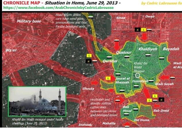
Homs
Here is a more accurate map of Homs from pro-opposition sources and i think that those green circles inside Homs are way too big its like the 3 districs are larger then a city and dont forget that the link between old Homs and the 2 other districs was cut off by the army in early April. https://pbs.twimg.com/media/BN787-uCEAAUs1e.jpg:large
- The size isn't intended to represent actual area. Neighbourhoods within cities are marked as size 6 unless they are unusually large. ~~ Lothar von Richthofen (talk) 16:50, 2 July 2013 (UTC)
- but at least separate them a little this way it looks like they're connected but they are actualy separated between old homs and kahaladyah
An activist and Syrian state media say regime troops are advancing in rebel-held parts of the city of Homs.
Homs-based activist Tarik Badrakhan said Saturday that Syrian troops seized control of buildings in the rebel-held district of Khaldiyeh, the first time government forces entered Homs neighbourhoods held by rebels for over a year. Syrian state media said troops were advancing and they had killed rebels in the area.
Badrakhan says troops began the move Friday night.
He says regime forces continued to pound the area with mortar shells and missiles Saturday, part a major offensive by President Bashar Assad's troops to seize control of territory they lost to rebels.
Homs is a strategic city located between the capital Damascus and the Syrian coast, a stronghold for the Assad regime.
[AP]
Homs neighborhoods contested army has moved in form the ground after 5 days of bombing them
And why did someone split Houla into 3 separate places -_- doesn't make any sense
Kurds?
What is the source for the kurdish villages and what is the yellow circle surrounded by a green/red circle mean? 85.227.177.123 (talk) —Preceding undated comment added 17:43, 1 July 2013 (UTC)
- For sources, see the map's edit history. There are many sources. The nested yellow and red/green circles mean that there is mixed Kurdish-govt/rebel control without ongoing clashes. ~~ Lothar von Richthofen (talk) 22:09, 1 July 2013 (UTC)
Can anyone please stop the adding of yellow villages. More and more tiny settlements are popping up, including in northern Aleppo governorate en Raqqah. Kurdish groups don't even hold territory in those areas? Raqqah is under Ahrar al-Sham and FSA control, the Killis Corridor under FSA control. This wasy it seems that Kurdish units have moved south and taken over a number of cities and towns. That is simply not correct.
And whats with the yellow circles around Qamishli and Hasakah, what do they represent`?
- These villages are (I think) mostly controlled by the Jabhat al-Akrad group, which is generally aligned with the PYD. These additions are all sourced, so there isn't cause to remove them outright barring conflicting information. The map does not directly reflect movement, so your complaints that it seems that Kurdish units are advancing are just your imagination. Can't help you there. As explained above, nested yellow and red/green circles mean that there is mixed Kurdish-govt/rebel control without regular active clashes. In Qamishli and Hasakah, the YPG controls some districts while the army and loyalist militias control others, while in Raqqah and Manbij, Jabhat al-Akrad controls some districts while Arab rebel groups control others. ~~ Lothar von Richthofen (talk) 19:58, 3 July 2013 (UTC)
- That's good. I've never heard of this Kurdish militia before, so it makes sense. But I still feel it's disproportionate. There are many Arab towns north of Raqqah city and near Manbij/Dayr Hafir which are under rebel control. This way it seems the Kurds are taking over large parts of northern Syria. I think we should add some of the greater towns under rebel control there to match things up. Towns like Suluq, Ayn Isa, Hamrat Nasir and Harran in Raqqah and Mashanek and towns on the road between Al-Bab and Manbij in Aleppo?
- If you have sources for control of these towns, present them, and I'll be happy to add them! ~~ Lothar von Richthofen (talk) 14:26, 7 July 2013 (UTC)
According to Kurdish reports, Al Nusra and other Jihadist groups have been expelled from Ras al-Ayn http://www.hawarnews.com/index.php/component/content/article/43-2013-02-24-21-16-12/4428-2013-07-17-07-38-20 https://now.mmedia.me/lb/en/nowsyrialatestnews/jihadists-expelled-from-flashpoint-kurdish-syrian-town-ngo-says — Preceding unsigned comment added by 75.34.43.112 (talk) 10:15, 17 July 2013 (UTC)
- There are, unfortunatly, no real sources. That's the point with those tiny towns. But if you look at them on wikimaps or google earth, you'll see that all of them are north of the line Raqqah-Tabqah-Dayr Hafir-Al-Bab. All those areas are under rebel control, since the front lines lies south of Raqqah and extends west towards the Kweiris airport and the city of Al-Safirah, which is under Nusra control. Rebels have stated several times that the highway from Tell Abyad to Raqqah is under their control, as well as northern Aleppo governorate (the Kilis corridor)
Qaboun Damascus
The outskirt is under SAA control according to Article of Hindu(neutral) and SANA(pro government)--Dimitrish81 (talk) 11:03, 6 July 2013 (UTC) http://www.presstv.ir/detail/2013/07/06/312503/syria-army-troops-advancing-in-homs/ presstv also reports it
Correcting myself this was al Qaboun industrial area. In this are the Army gain control and separated Qaboun and Jobar..... According to pro government SANA article the army has advanced further in the neighbourhood without however gaining total control in that.--Dimitrish81 (talk) 20:47, 12 July 2013 (UTC
- Citing SANA is completely useless it is OWNED by the governement so it isn't even reliable citing SANA is like citing a rebel fighter (Amedjay) --78.232.100.63 (talk) 15:43, 17 July 2013 (UTC)
- But perhaps you dont have any problem to cite UK-based pro-"rebel" activist one-man group so-called "SOHR", and claim that is a "reliable source", or even "rebel" blogs and Facebook pages, totally breaking WP rules. Am I wrong?.--HCPUNXKID (talk) 17:59, 18 July 2013 (UTC)
- Syrian Army is advancing in the suburbs of Damascus slowly due to the buildings and hides of the ground....However any news of take over must be mentioned by a pro government or a pro opposition (SOHR) source and a least be verified by both sources to be accurate as possible--Dimitrish81 (talk) 20:24, 18 July 2013 (UTC)
Nawa
Rebels have captured parts of Nawa but dont hold it is still contested — Preceding unsigned comment added by 79.126.232.67 (talk) 17:12, 18 July 2013 (UTC)
Opposition fighters in Syria say they have captured most parts of Nawa city in Deraa province.
Meanwhile, there has been more fighting in Aleppo city, where opposition fighters say they have made gains.
Al Jazeera's Mohammad Vall reports
Ghabaghib is in Government control no rebel activity reported in that town also Everything south of Daraya is in government hands those towns have seen only side efects of the battle in Daraya so if there are few gun battles on the near the town it doesnt mean they are fighting for the town Dama Suwayada province no reported fighting(no source) should be red in that province it is hevely controled by the government and most of the population suports the government
Al-Zabadani mostly in rebel hands SAA is holding it under sige should be green with a large red circle
Towns of Dumayr and Nasiriya near the same named airbases should be added (government controled)
Talbiseh
By all journalist accounts (not activist like so-called "SOHR", blogs or Facebook pages, wich are not allowed as sources in Wikipedia) and common sense, Talbiseh is wether disputed or encircled (like neighbouring Ghantu). Presenting it as totally "rebel"-held is simply denying reality (even so-called "rebels" claim constant shelling, while government claim that Syrian forces have occupied some buildings in the town).--HCPUNXKID (talk) 17:55, 18 July 2013 (UTC)
- No journalists accounts have produced anything of what you said. Only SANA. Sopher99 (talk) 18:30, 18 July 2013 (UTC)
- "All journalist accounts" meaning one mention of SANA an online article. SANA is a "journalistic" source for this war in the same way that Der Stürmer or Pravda is for WWII. Its impenetrable newspeak makes it difficult to actually understand "the reality of events" on the ground. "Destroyed terrorist gatherings"? "Conducted qualitative operations"? What the fuck is that supposed to mean? At the very least, SOHR can use meaningful words like "clashes", "shelling", and "bombardment". Interestingly, I have not been able to find any mention of buildings in Talbisah city being taken over in any SANA reports from early July: [7] [8] [9] [10]. ~~ Lothar von Richthofen (talk) 20:56, 18 July 2013 (UTC)
Army bases and Towns
This is the base of the 155 brigade it is also a missile base from where scud and other missiles are lunched at ground targets (North of Adra one of the largest bases by terrain)
http://wikimapia.org/#lang=en&lat=33.752890&lon=36.531601&z=11&m=b&show=/23181596/&search=Aleppo
4th armored division base north of Mezzeh also called Mezzeh base
http://wikimapia.org/#lang=en&lat=33.511916&lon=36.181927&z=14&m=b&search=Aleppo
Republican base(brigade 104) south-east of Jamraya (subject of Israeli airstrikes)
http://wikimapia.org/#lang=en&lat=33.557418&lon=36.273937&z=14&m=b&show=/24523307/&search=Aleppo
Towns of Ad-Dumeir and Al-Nasiriah under government control the are near the two airbases with same names (they are much larger then some villages on this map and yet they are not on the map)
http://wikimapia.org/#lang=en&lat=33.876402&lon=36.827545&z=14&m=b&show=/2238277/&search=Aleppo
http://wikimapia.org/#lang=en&lat=33.641062&lon=36.695709&z=14&m=b&show=/2238277/&search=Aleppo
These should be added especialy the bases cuz they are one of the largest and have strategic value for the Syrian Army
Sednaya/Al Tall
Hello. I had a post here about adding Sednaya here before because i did not found it on the first sight. On satelite picture it seems to be more in the southeast, like Al Tall. Maybe you should look about that.
http://old.wikimapia.org/#lat=33.7233891&lon=36.4925807&z=11&l=5&m=b&show=/894211/de/Saidnaya
OberschIesien90 (talk) 18:03, 4 July 2013 (UTC)
Kurdish/Rebel clashes
I am technically unqualified to do it myself, but would anyone please add the villages/towns that http://en.wikipedia.org/wiki/2012_Syrian_Kurdistan_campaign#Renewed_Rebel-Kurdish_clashes mentiones in the last days (since 17th of July). I found some of them on the map (Tal A'lo is now kurdish and no longer contested, according to the page i linked to) but others I was totally unable to locate. Thanks in advance!--Andylee Sato (talk) 16:36, 19 July 2013 (UTC)
The clashes in Tal Abyad broke out after jihadists ambushed a school that Kurdish fighters in the town were using as a base.Syrian Kurdish fighters in the north fought fierce battles against jihadists and captured a commander of the Islamic State of Iraq and the Levant (ISIS) late Saturday, a monitoring group said. "Battles pitting fighters from the Kurdish Fighters brigade against ISIS and other groups are raging on in several areas of Tal Abyad in Raqa province, after [Kurdish] fighters captured ISIS' emir in the town," said the Syrian Observatory for Human Rights.https://now.mmedia.me/lb/en/nowsyrialatestnews/kurds-capture-jihadist-commander-in-north-syria46.200.245.82 (talk) 11:13, 21 July 2013 (UTC)
Ras Al Ayn Boarder Passage
The passage is under PYD control, which took it soon after the town itself.
Clashes with turkish army and PYD was also reported and video from Anadolu Ajansi from the turkish side saw clearly PYD fighters taking the passage and rip and throw to the ground the Qaeda flags.....--Dimitrish81 (talk) 11:47, 21 July 2013 (UTC)
Daraa Countryside
According to pro government SANAa number of cities are been taken over in Daraa countryside. Can we have that cities in map position because they are not displayed.--Dimitrish81 (talk) 15:33, 24 July 2013 (UTC)
Also it was earlier reported that Ghabaghib in north Deraa province was captured by military. http://en.wikipedia.org/wiki/2013_Daraa_offensive#Government_counter-attack
Since then no reports of fighting took place so can someone please change the town to a red dot. — Preceding unsigned comment added by 218.185.9.110 (talk) 05:03, 25 July 2013 (UTC)
al-Hara clashes and bomb. https://www.facebook.com/syriaohr/posts/397305533711124 https://www.facebook.com/syriaohr/posts/397456723696005 In late June, rebel forces were in fear of being routed by the Army in southern Syria and losing control of their safe zones on the Jordanian border. By 26 June, government forces had captured the villages of Itlaa and Basr As Sham and fighting was raging outside the village of al-Sheikh Maskin http://en.wikipedia.org/wiki/2013_Daraa_offensive#Government_counter-attack http://www.washingtonpost.com/world/middle_east/syrian-rebels-say-they-need-us-weapons-now/2013/06/26/103d1d70-dd13-11e2-a484-7b7f79cd66a1_story.html — Preceding unsigned comment added by Marcinkrkpl (talk • contribs) 07:11, 25 July 2013 (UTC)
Homs Countryside
The town of al-Sukhneh in Palmyra countryside according to pro government SANA is controlled by the army since Tuesday and today 6 more militants of Nusra were arrested--Dimitrish81 (talk) 19:15, 24 July 2013 (UTC)
According to SOHR, the army at is at least present in the town. Change to disputed? OberschIesien90 (talk) 20:32, 24 July 2013 (UTC)
SOHRadmitted 6 hours ago that the town has been taken over by Army announcing the death of the local emir--Dimitrish81 (talk) 19:36, 25 July 2013 (UTC)