
Talk:Control of cities during the Syrian civil war/Archive 44
| This is an archive of past discussions about Control of cities during the Syrian civil war. Do not edit the contents of this page. If you wish to start a new discussion or revive an old one, please do so on the current talk page. |
| Archive 40 | ← | Archive 42 | Archive 43 | Archive 44 | Archive 45 | Archive 46 | → | Archive 50 |
YPG in al-Hawl
Multiple non-pro-YPG sources report YPG has taken over town of al-Hawl east of Hasaka:
- http://www.alahednews.com.lb/fastnews/258866/-%D8%AF%D8%A7%D8%B9%D8%B4-%D9%8A%D9%86%D8%B3%D8%AD%D8%A8-%D9%85%D9%86-%D8%A8%D9%84%D8%AF%D8%A9-%D8%A7%D9%84%D9%87%D9%88%D9%84-%D8%A5%D9%84%D9%89-%D8%A7%D9%84%D8%B4%D8%AF%D8%A7%D8%AF%D9%8A-%D9%81%D9%8A-%D8%B1%D9%8A%D9%81-%D8%A7%D9%84%D8%AD%D8%B3%D9%83%D8%A9-%D8%A8%D8%B9%D8%AF-%D8%AA%D9%82%D8%AF%D9%85-%D8%A7%D9%84%D9%88%D8%AD%D8%AF%D8%A7%D8%AA-%D8%A7%D9%84%D9%83%D8%B1%D8%AF%D9%8A%D8%A9#.VPclrPnF870
- http://slabnews.com/article/167143/ Roboskiye (talk) 15:37, 4 March 2015 (UTC)
- It is pro-government sources. Also I'm not saying that these sources not reliable simply pointed out what kind this sources. Hanibal911 (talk) 16:10, 4 March 2015 (UTC)
- http://slabnews.com/article/167143/ Roboskiye (talk) 15:37, 4 March 2015 (UTC)
Its good for change of control .Very quick advance isis looks unable to stop it ,could go to Shadaddah .Pyphon (talk) 16:16, 4 March 2015 (UTC)
i agree with Hannibal here,wait for more sources to say so.Alhanuty (talk) 16:49, 4 March 2015 (UTC)
So we just changed 10 villages to YPG control with no source giving there names ,then we get 2 sources naming 1 village and you say wait for more sources .Pyphon (talk) 17:10, 4 March 2015 (UTC)
because this is a pro-regime source,meanwhile the other ones where actually pro-ISIS and Pro-YPG sources saying so.Alhanuty (talk) 17:15, 4 March 2015 (UTC)
SO you saying no pro-regime source for YPG gains that's news to me but we can use YPG .Pyphon (talk) 17:25, 4 March 2015 (UTC)
- Pyphon Syrian army and YPG in some cases cooperated in fighting against ISIS in Hasakah province. So that pro government sources can exaggerate achievements of YPG in their battle against ISIS. Hanibal911 (talk) 17:39, 4 March 2015 (UTC)
Ok so no pro government source for YPG in Hasakah and no pro rebel source for YPG in Aleppo . thankyou Pyphon (talk) 17:49, 4 March 2015 (UTC)
- I believe it depends in each case. YPG has a very one-of-a-kind situation in the Syrian Civil War. It's not part of the opposition. It's not loyal to the regime. Yet it has fought both (if we still call JAN "part of the mainstream opposition") at the same time as resuming relations with both. Many pro-opposition and pro-regime sources dislike the YPG and could be biased against it because of that. But both the opposition and the regime are cooperating with it in different places to fight ISIL. So it's possible for a pro-opp source to be biased in favor or against it in the same area. The same goes for pro-regime sources. And the same also goes for pro-YPG sources towards both the regime and the opposition. The line is not clear cut and we have to decide in each case weather the report is more likely to be biased against or in favor of YPG. I took the time to write all this because quite often a pro-opposition source is treated the same as a pro-YPG source and I believe that's not helpful for the editing process. Saeed alaee (talk) 20:22, 4 March 2015 (UTC)
- I see the YPG in the opposing side of ISIS, just like the SAA and the FSA their are opposites, in terms of fighting and goals. The FSA its a Insurgent/Revolutionary force and the SAA a Counter-Revolutionary force. We could use any non-YPG source(Regime, opposition, pro-alqaeda, isis) to validate Kurd advances. Thats my opinion, since we make the same with the SAA FSA affair.Mr.User200 (talk) 22:11, 4 March 2015 (UTC)
- SOHR reported about clashes between YPG and IS in the area located between the two towns of Tall Brak and al-Hawl.SOHR So most likely the town of al-Hawl not was captured by the Kurds because fighting still going in area between towns of Tall Brak and al-Hawl. Hanibal911 (talk) 09:50, 5 March 2015 (UTC)
- I see the YPG in the opposing side of ISIS, just like the SAA and the FSA their are opposites, in terms of fighting and goals. The FSA its a Insurgent/Revolutionary force and the SAA a Counter-Revolutionary force. We could use any non-YPG source(Regime, opposition, pro-alqaeda, isis) to validate Kurd advances. Thats my opinion, since we make the same with the SAA FSA affair.Mr.User200 (talk) 22:11, 4 March 2015 (UTC)
ABU DUHUR-AIRBASE! According to the new JN-Idlib-video the airbase is now completely surrounded.The village of Tabarat Al-Kashir was also seized by Nusra and FSA after SAA left without a fight into the airbase-interieur. 79.233.27.80 (talk) 10:33, 5 March 2015 (UTC)
- It is unreliable source for editing on map. Because it is just statement from Al Nusra and we not have confirmations this data from reliable or from pro-government sources. Firstly I Also seen this video and in this video from Al Nusra not said that Al Nusra cooperate in this operation against Syrian troops with moderate rebels. And secondly we cant trust only statements by JAN. Hanibal911 (talk) 12:11, 5 March 2015 (UTC)
- Considering that the base has been under siege for over a year, the only supplies and reinforcement coming by air, that is a bit like the regime saying they control downtown Damascus. The occasional forays (with air support) of regime forces to neighbouring villages is probably only to destroy rebel preparations to take the base.
- As for Nusra claims, propaganda is one of their strengths. As well as encouraging the weak-willed to commit suicide, and kidnapping innocents for ransom. At least Nusra is not as bad as Daesh (ISIS), nor even close to as bad as the regime. André437 (talk) 01:44, 6 March 2015 (UTC)
- That is, in your opinion the militants from Al Nusra it is a positive guys. Although all the recent events suggest that they are gradually turning into something like ISIS. Even Western countries that support the moderate rebels call Al Nusra as terrorists. And they betrayed the moderate rebels also as ISIS earlier and now in many areas Al Nusra fights not only against Syrian troops but also against moderate rebels. Hanibal911 (talk) 07:16, 6 March 2015 (UTC)
- Agree that Nusra are far from angels, and have an agenda to destroy the moderate rebels. Which Nusra had largely hidden before attacking the SRF (on false pretenses). Even Hazm, which previously had successfully avoided conflicts with other rebel groups, as well as being one of the more professional/better trained rebel groups (being led by defected officers).
- I would say that Nusra have a way to go to be as bad as Daesh, and the regime is light years worse than both. The trick is to salvage the civil administration while losing the regime "security" apparatus. André437 (talk) 02:13, 7 March 2015 (UTC)
Daraa
Recent media updates - from today, in fact - say rebels of the Southern Front have counterattacked against the SAA and Hezbollah in Daraa. This article (https://now.mmedia.me/lb/en/NewsReports/564911-southern-syria-fighting-heats-up) mentions that the rebels have been able to retake Tall Qareen and Tall Fatima, as well as the town of Sultaniyah.
More articles shed some light on it:
- http://www.alaraby.co.uk/politics/bfd2adb9-51bb-44f7-b833-0e9a4f1e837a (the Arab source quoted above)
- http://www.thenational.ae/world/middle-east/syrias-southern-battleground--map (map shows clashes around Kanaker city, which is reported to be rebel-held by opposition Twitter sources)
So this would mean Kafr Naisj to rebel held, as well as Tell Qareen. I'm unsure about Sultaniyah and Tell Fatima, since both of them are further north on his map. Any ideas? — Preceding unsigned comment added by 84.31.204.195 (talk) 17:15, 3 March 2015 (UTC)
- You source reported that Opposition sources said the rebels regained control of Tlul Fatima in the countryside north of Daraa, after violent clashes with the security forces and elements of the Iranian Revolutionary Guard.Alaraby But not independent confiemation this data. Opposition sources told the London-based daily that rebels had taken control of the Tuloul Fatima area north of Daraa after heavy clashes with regime and IRGC troops, while the Tel Qarin area and town of Soultaniye had also been retaken.NOW News So at the moment we only have a statement from the rebels, and nothing more. But we cant edited only on basis of rebel statements. Hanibal911 (talk) 17:24, 3 March 2015 (UTC)
- This map here which you provide as a source and which said that clashes in Kanaker Absolutely not correct because it also shows that the clashes are in the city Sheikh Maskin but this city is under control by rebels. Also we have previously agreed not to use such maps because they are very often mistaken. And only pro opposition sources said that Kanaker in rebel hands not confirmtion from reliable sources. On the basis of similar map from Reuters in last year we noted the city Madayya in the Eastern Ghuta as under the control of the army but it turned that the map was wrong. Hanibal911 (talk) 17:52, 3 March 2015 (UTC)
- This map is one of the worst maps I have ever seen. Fight in Sheikh Miskeen, rebel cut off Daraa city, teritory beetwen Daara city and Jordan bordern control by SAA. Probably in other world. Nothing new - when rebe lost some citys/villages next day they always says that they recapture all area which they lost previous days(217.99.142.124 (talk) 18:11, 3 March 2015 (UTC))
- Also this article Al Araby was published in morning 2 February here confirmation here and this source NOW News today just republish yesterday's data from this source.Al Araby And not one reliable source including SOHR not confirmed those data from rebels. Also today pro opposition source condirmed that Tall Qareen and Tall Fatima and Sultaniyah under control by Syrian troops.Archicivilians So we cant edit map because data from rebels not have confirmations. Hanibal911 (talk) 18:27, 3 March 2015 (UTC)
- This map is one of the worst maps I have ever seen. Fight in Sheikh Miskeen, rebel cut off Daraa city, teritory beetwen Daara city and Jordan bordern control by SAA. Probably in other world. Nothing new - when rebe lost some citys/villages next day they always says that they recapture all area which they lost previous days(217.99.142.124 (talk) 18:11, 3 March 2015 (UTC))
Upper source seems to be pulling the report out of its ass even rebels said they lost the areas.I mean Tel Fatima and the other places are under Syrian armed forces control and that is 100% sure.We have a lot of video and picture material to prove this so stop using propaganda sources which always claim that the rebels have recaptured everything after a day or two as that is just wishful thinking.Daki122 (talk) 18:39, 3 March 2015 (UTC)
Confirmation by rfsmediaoffice that Tal Al-Fatimah and Tel qareen are under SAA control. So indeed 100´% certain. More interesting is, (although it's a pro-opposition source so potentially not reliable and unusable) , that they mention targeting the military housing complex in Al-Sanamein. Something to keep an eye on in the future Raspoetin89 — Preceding undated comment added 08:28, 5 March 2015 (UTC)
SANA reported they killed insurgents in Al Faq'ah and Qarfa. Do we need to change Al Faq'ah and Qarfa to contested then? Raspoetin89 — Preceding unsigned comment added by 2A02:1811:A016:A800:4C1A:A994:31B7:CD89 (talk) 10:36, 7 March 2015 (UTC)
Durin -Latakia
SAA Captured durin town SOHR: http://www.syriahr.com/2015/03/%D9%82%D9%88%D8%A7%D8%AA-%D8%A7%D9%84%D9%86%D8%B8%D8%A7%D9%85-%D8%AA%D8%AA%D9%82%D8%AF%D9%85-%D9%81%D9%8A-%D8%B1%D9%8A%D9%81-%D8%A7%D9%84%D9%84%D8%A7%D8%B0%D9%82%D9%8A%D8%A9-%D8%A7%D9%84%D8%B4%D9%85-2/
NDF official: https://www.facebook.com/National.Defence.Forces.NDF/photos/a.434975923224445.97932.434107746644596/812281968827170/?type=1Hwinsp (talk) 12:09, 6 March 2015 (UTC)
Al manar reporter inside doreen town after saa and ndf captured the town https://www.facebook.com/somar.hatem/posts/952710001414955Hwinsp (talk) 12:44, 6 March 2015 (UTC)
Salma being shelled now .Pyphon (talk) 13:56, 6 March 2015 (UTC)
- [1] Pro-gov source saying SyriaAirForce targeted a rebel HQ in Qastal Maaf in Latakia. So Qastal Maaf should become rebel-held or at least contested. ChrissCh94 (talk) 16:12, 7 March 2015 (UTC)
Border with Lebanon
The page 9 of that report has got the current version of the Qalamoun mountains situation, please update the map.--Catlemur (talk) 00:28, 7 March 2015 (UTC)
The map is not precise enough for our standard. It gives only rough estimation of the areas under control of the various factions. The only strange thing is that Qaryatayn appears unde rISIS control. Is there any other source backing up this claim?Paolowalter (talk) 17:43, 7 March 2015 (UTC)
Zabadani is green, while it is in fact under IS/Nusra control--Catlemur (talk) 18:47, 7 March 2015 (UTC)
- talk Source not said that Qaryatayn under control of ISIS source just said that some ISIS units operated in this area and nothing more. Also pro opposition source clear showed that the town of Qaryatayn under control by Syrian troops and Hezbollah.here Also Catlemur SOHR several times reported about clashes between Syrian troops and rebels inside city of Zabadani.SOHR Hanibal911 (talk) 19:59, 7 March 2015 (UTC)
Al Masdar
Let us once and for all clarify the issue about this source. Al Masdar it is clear pro government source and use data from this source for display success of Syrian army is a violation of previously accepted rules of editing. So that dear friends, let us not break the rules. Hanibal911 (talk) 18:34, 7 March 2015 (UTC)Paolowalter (talk) 21:48, 7 March 2015 (UTC)
- The rule is that we accept info from reliable sources or from biased and less reliable sources if
they support gains from the other side(s). In the past SOHR was put in the first category, many source s in the second, most of the twitter sources cannot be used at all. The quality of SOHR has plummeted recently, while Al Masdar has proven to provide information of good quality quite unbiased, even if su pports the government. Furthermore it is a journal with people on the ground not somebody operating from Europe. Nobody has ever provided evidence of Al-Masdar of lying sistematically. Therefore ther eis no reason to reject it, in particular if SOHR is retained.Paolowalter (talk) 22:08, 7 March 2015 (UTC)
- I agree, but in the area of eastern Syria, only pro SAA including AlMasdar said about name of village taken by gov and ypg. SOHR, rebels source and neutral source said only number village without name. If we have confirmation from a neutral / rebel source about the number of villages and agree more or less with the amounts reported by gov source we can probably use meaningful names villages given by the pro SAA? 83.5.180.127 (talk) 18:47, 7 March 2015 (UTC)
- We use data from pro-government sources for display success of Syrian army or data from pro-opposition sources for display success of moderate rebels if those data confirmed the reliable source. And not otherwise. Hanibal911 (talk) 19:06, 7 March 2015 (UTC)
- That does not reply to the question. The answer is yes, when an advance from one side is confirmed in size and location from reliable source or from sources opposite to the advancing side, the list of names of villages can be taken also by source supporting the advancing side if nothing else is available. Otherwise it is practically impossible to find out those names for villages in the countryside, like Hasakah province.Paolowalter (talk) 21:21, 7 March 2015 (UTC)
The majority view that was established last time [Last SOHR discussion] is that Al-Masdar may be used on the map with a corroborating source, just like SOHR. They are mostly accurate with their reporting, so they fall under that category. In actual articles, they may be cited with he "reportedly" tag.XJ-0461 v2 (talk) 22:10, 7 March 2015 (UTC)
Change in Latakia
After the capturing the Dowrin by SAA the news confirmed that the SAA backed by NDF penetrated to Salma town so the Salma village should be contested
http://www.almasdarnews.com/article/latakia-al-nusra-suffers-significant-setback-syrian-army-enters-salma/5.232.162.16 (talk) 09:40, 7 March 2015 (UTC)
- :: [2] Pro-gov source saying SyriaAirForce targeted a rebel HQ in Qastal Maaf in Latakia. So Qastal Maaf should become rebel-held or at least contested. ChrissCh94 (talk) 16:13, 7 March 2015 (UTC)
- ChrissCh94 Source maybe wanted said near Qastal Ma'af or in area Qastal Ma'af. Source not said that rebels HQ was located inside this town. Need more data. Hanibal911 (talk) 18:07, 7 March 2015 (UTC)
- ChrissCh94 Also sometimes sources make mistakes in reports as it was with the pro opposition source Qasion News when this source in one report said that village of Umm Sharshun it is regime stronghold but in the same day later reported that regime troops shelled of this village which long time under control by FSA. So that some times sources make mistakes in reports. Also this village long time under control by Syrian troops and located deep of area which is under control by Syrian troops.here And now clashes between army and rebels in Salma area. Also not one reliable, pro government or pro opposition sources not said that Qastal Maaf under control by rebels of contested. Hanibal911 (talk) 18:27, 7 March 2015 (UTC)
- Also previously biased the pro opposition source clear showed that Qastal Ma'af under control by Syrian troops.Archicivilians and also later pro opposition source deSyracuse Hanibal911 (talk) 18:40, 7 March 2015 (UTC)
- Also SOHR only report that helicopters dropped barrel bombs in area of Qastal Ma’af in the north of Lattakia but not said that rebels located in this town or that army dropped bombs inside this town.SOHR So we have no reason to change the status this town. Hanibal911 (talk) 06:36, 8 March 2015 (UTC)
Al Nusra advanced against moderate rebels in Aleppo
SOHR reported that al-Nusra took control army base 46th Regiment in area near town of al-Atarib after violent clashes against Hazm movement which lost its bastions and HQs in the 2nd reef of Mohandsin, Kafar Noran, al-Mashtal, and al-Meznaz areas in the western countryside of Aleppo. And fighters from Hazm movement pulled back into town of al-Atarib.SOHR Also another reliable source reported that Al Nusra take full control of Brigade 46, near Atareb, al-Mashtal and reef al Muhandeseen west of Aleppo.Elijah J. Magnier and that Al Nusra take full control of all area around town of Atareb.Elijah J. Magnier Hanibal911 (talk) 17:28, 28 February 2015 (UTC)
111th regiment should be changed to lime again since SOHR said that Levant front is in control of that base again after the agreement. In before someone says "maybe SOHR is wrong", a reminder we used the same source to change that base to grey 1 month ago. DuckZz (talk) 18:02, 1 March 2015 (UTC)
- In report from SOHR for 27 February was said that an agreement has been sign between Hazm and the Nusra in Daret Ezzah. And according to this agreement handing the Regiment 111 over to al- Jabha al- Shameyya as a trust until resolve the dispute between the two sides or holding a new agreement.SOHR But probably this treaty has not entered into force. Because the next day Al Nusra took control on the Regiment 46 near the town of al- Atareb after violent clashes against Hazm movement which is lost its bastions and HQs in the 2nd reef of Mohandsin, Kafar Noran, al-Mashtal, and Miznaz in the western countryside of Aleppo and Hazm movement pulled back into town of al-Atarib.SOHR Aslo other a reliable source reported that Al Nusra takes full control of all around town of Atareb and Al Nusra the warned Hazm movement lay down their arms.Elijah J. Magnier also pro opposition source said that for now the town of Atarib(FSA stronghold) is surrounded by Al Nusra.here So it's clearly confirms that the agreement has not been implemented and fighting continues. Hanibal911 (talk) 19:44, 1 March 2015 (UTC)
- TheDailyStar was used to change regiment 111 to grey last week, not a month ago. Clashes between Nusra and moderates in Atareb: http://syriahr.com/en/2015/03/clashes-take-place-in-the-north-of-aleppo-and-the-nusra-hazm-clashes-leave-80-bodies/ Ariskar (talk) 10:42, 2 March 2015 (UTC)
Lots of tweets now that Hazm is dispanding seems like Al nusra has killed of moderate opposition in north Syria .Pyphon (talk) 15:04, 2 March 2015 (UTC)
- Pyphon Hazm disbanded in favour of full integration into LF. Since there have been reports (e.g.) that Nusra agreed to hand over base 46 to LF. Which makes sense since Hazm was part of the LF alliance before, and is much stronger than Nusra (or any other rebel group) in Aleppo province. André437 (talk) 06:43, 8 March 2015 (UTC)
Regiment 46
There were reports from pro-oppositon channels that JAN will leave the regiment 46 after they signed an agreement with the Levant Front (they will be in charge of it). There's no point in posting those sources here, as they can't be used to make changes.
- But i found this source "Aleppo Today", it's obviously not pro-government oriented but i guess its reliable with that much followers and they never wrote anything bad about Al Nusra as they see them as rebels like any other. In this source, they said that Jabhat Shamya (Levant front) will take over the base after JAN confirmed the agreement. What other editors think ?? DuckZz (talk) 20:25, 7 March 2015 (UTC)
- DuckZz Most likely, these data correspond to reality but still to be sure on 100%, let's wait confirmation from a neutral source. About this also said another opposition source.Archicivilians Hanibal911 (talk) 21:12, 7 March 2015 (UTC)
- SOHR condirmed that Al Nusra withdrew from Regiment 46 in Atarib countryside west of Aleppo and now Regiment 46 under control of Islamist factions and moderate rebels.SOHR Hanibal911 (talk) 06:50, 8 March 2015 (UTC)
- Pro-opp video saying Duwar al Zaytoun is regime held. [3] [4] Hanibal911 ChrissCh94 (talk) 01:13, 8 March 2015 (UTC)
Musharifah al Janubiyah - E-Homs
SAA forces have taken over Moushayrifah al Janubiyah south of Moushayrifah al Shamaliyah following clashes with ISIS per SOHR. [5] ChrissCh94 (talk) 01:00, 8 March 2015 (UTC)
Jabhat al-Akrad
Do we count Jabhat al-Akrad as yellow or green? --Ahmetyal (talk) 17:59, 7 March 2015 (UTC)
- Ahmetyal This is joint forces Kurds and moderate rebels.
 Hanibal911 (talk) 18:46, 7 March 2015 (UTC)
- Hanibal911 Some villages/towns near Afrin is coloured green, but are in Akrad-control. Should I change these to ? --Ahmetyal (talk) 19:08, 7 March 2015 (UTC)
- Hanibal911 Some villages/towns near Afrin is coloured green, but are in Akrad-control. Should I change these to
- Ahmetyal Possible! But for now I think that we must ask of other editors of their opinion about this issue. Hanibal911 (talk) 19:19, 7 March 2015 (UTC)
First you need to provide neutral or rebel sources for these edits. DuckZz (talk) 20:15, 7 March 2015 (UTC)
- I would favour green for Akrad, since in terms of long-term goals they are unequivocally aligned with FSA (which they were once formally part of), but I'm ok with whatever the consensus ... André437 (talk) 07:47, 8 March 2015 (UTC)
Duwar Al Zaytoun
Pro-opp video saying Duwar al Zaytoun is regime held. [6] [7]. They say that Duwar Al Zaytoun is the regime's main supply route to Pashqoi and that it is being targeted on a daily basis in order to isolate Pashqoi. ChrissCh94 (talk) 10:27, 8 March 2015 (UTC)
- I always pointed it out on the basis of PetoLucem map and various reports. It must be reported on the Aleppo page: Duwar al Zaytoun from contested to red.Paolowalter (talk) 11:02, 8 March 2015 (UTC)
- I already did but to no avail. ChrissCh94 (talk) 11:11, 8 March 2015 (UTC)
YPG advance in Hasaka
documents.sy erport advance of YPG in Hasaka NE (probably in areas erroneously marked yellow already). Furthermore there are fighting west of Hasakah.Paolowalter (talk) 16:59, 5 March 2015 (UTC)
- Pro ISIS source yesterday reported that ISIS take over Umm Rus, which links Tel Hamis and Tel Brak.here and also today pro ISIS source reported that later 50 YPG fighters was killed after YPG failed their attack on Umm Rus.here also pro opposition source Documents.sy reported about clashes between YPG and ISIS in the vicinity of the villages Tel Sawan and Umm Rus of Hasaka countryside.Documents.syDocuments.sy Hanibal911 (talk) 17:59, 5 March 2015 (UTC)
Pro gov source said about 9 villages/farms take by SAA today in south Qamishli [8] I have no idea where they are location. 83.5.180.127 (talk) 18:38, 7 March 2015 (UTC)
- Another pro gov report [9] with location Salehia and Msheirfeh Large and others 83.5.180.127 (talk) 20:19, 7 March 2015 (UTC)
- Confirmation by SOHR regime forces advanced in Qamishli and took control on 5 villages. 217.99.114.198 (talk) 12:15, 8 March 2015 (UTC)
Sheick Meskim
I am curious to see which excuse will be brought to prevent Sheick Meskim from going contested after SOHR.Paolowalter (talk) 09:21, 8 March 2015 (UTC)
- Considering that it is a fairly big town with a large number of rebel forces present, I would favour waiting for more reports to ensure it is not just a temporary incursion or raid to test rebel defenses. The post says only one (rebel) fighter was killed, which is not very significant for such a large strategic town. Not saying that it is not contested, just better to wait to be sure ... André437 (talk) 09:58, 8 March 2015 (UTC)
- Actually, it reports: "Clashes erupted between the regime forces and allied militiamen against the Nusra, rebel and Islamic factions ". Losses are always under reportedPaolowalter (talk) 11:02, 8 March 2015 (UTC)
- What is remarkable is that [10] SANA reported yesterday they clashed west of Qarfa, but they didn't say there were clashes in Sheikh Miskin.( SANA adjusted their report, because yesterday they said clashes in Qarfa) But the SOHR report is of 8th March, one day later, and reports clashes in Sheikh Miskin. Although we don't how severe those clashes are, in my humble opinion, we can say that the regime is the attacking force now in the area east of Sheikh Miskin. ( correct me if I'm wrong with that statement) I didn't see any recent reports anymore of rebels attacking the electric grid station and such. Maybe it would reflect the current situation better if we would set Sheikh Miskin to besieged in the east, instead of Qarfa besieged by rebels. Raspoetin89
- I want to add yet that same report mentioned rebel presence in Al Suhayliyah and Qaita, so change to contested?Raspoetin89
- SANA not said that clashes to west of Qarfa. SANA reported that army units pounded rebels hideouts in Ibta’a, west of Qarfa.here So this said about atack against rebels in the city Ibta but not about clashes to west of the village Qarfa. You need to carefully read your source. Hanibal911 (talk) 11:52, 8 March 2015 (UTC)
- Yet better to wait more data about situation in the city of Shaykh Miskin. Before we mark him as contested. Hanibal911 (talk) 12:01, 8 March 2015 (UTC)
- Isn't it a bit strange to refer to Ibta'a like that (using a tiny village to locate a bigger more known one?) What I see is a clear summary of events in places, I was thinking they really meant West of Qarfa as place and not as help to locate Ibta'a. But agree about Sheikh Miskin. Too big to mark as contested based on the current reports. Raspoetin89
- Raspoetin89 In article clearly said about a town of Ibtaa. So no need to distort data in the article. Nevertheless, I am not saying that we should be noted as contested the city of Shaykh Miskin or the town of Ibtaa. I just pointed out that said in article! Hanibal911 (talk) 12:39, 8 March 2015 (UTC)
- SANA not said that clashes to west of Qarfa. SANA reported that army units pounded rebels hideouts in Ibta’a, west of Qarfa.here So this said about atack against rebels in the city Ibta but not about clashes to west of the village Qarfa. You need to carefully read your source. Hanibal911 (talk) 11:52, 8 March 2015 (UTC)
Uqayribat
Pro-opp [11] and pro-gov [12] sources saying clashes are near and around Uqayribat. I thought it was far from the front lines but it seems the clashes are much closer than we thought. And SOHR defined the frontline in Eastern Hamah as such: As Sa'an area - Mab'ujah area - Mas'oud area - Uqayribat area. Opinions? ChrissCh94 (talk) 12:59, 8 March 2015 (UTC)
- SOHR to,and I think putting a siege or contested mark will be the right thing for this areas.Lindi29 (talk) 14:51, 8 March 2015 (UTC)
- I think a red semi-circle would be more appropriate. ChrissCh94 (talk) 15:07, 8 March 2015 (UTC)
Removing old marks we don't have any recent information for?
Should we consider removing marks such as the lime 4 by 4 dots south west of Palmyra that have been around for months without any sources to suggest change and that look like they probably are wrong? That rural support would be completely isolated and pretty much surrounded in the desert and the latest BBC map doesn't suggest there is any rebel presence nearby. Banak (talk) 16:15, 8 March 2015 (UTC)
There actually is. SOHR often reports that rebels ambushed or destroyed a car beloging to "regime forces" SE of Palmyra. It happens over and over again few times in a month. This infographic, thought pro-rebel, might me helpful DuckZz (talk) 16:53, 8 March 2015 (UTC)
- Desert areas are a haven for insurgents because they are hard to control and monitor. Despite fire control from the SAA, the rebels and Isis fighters can roam parts of it untouched. This rural presence also indicates how arms and fighters are transferred between distant provinces. Kinda explains how for example, in 2013, ALeppo rebels sent reinforcements via the desert towards Al Qusair in Homs. ChrissCh94 (talk) 17:38, 8 March 2015 (UTC)
T2 Pumping Station
[13] Very interesting pro-opp article mentioning a regime attack backed by tribal fighters (trained in Palmyra) where they attacked ISIS positions in the field, killing 50 ISIS fighters and stealing their equipment. This is why ISIS called in huge reinforcements and booby-trapped all the main roads and highways in Eastern Deir Ez Zoor that lead to the field. So I suggest adding a regime rural presence icon or a red semicircle near the T2 Pumping station because it shows that regime forces do have access to this area. T2 is still under ISIS control because the article also says that the attacking forces retreated. ChrissCh94 (talk) 17:58, 8 March 2015 (UTC)
- Another pro-opp source reporting the incident [14] ChrissCh94 (talk) 17:59, 8 March 2015 (UTC)
- Agreed! Hanibal911 (talk) 18:01, 8 March 2015 (UTC)
- Here another source reported about this incident.Al Asema Hanibal911 (talk) 18:18, 8 March 2015 (UTC)
- Agreed! Hanibal911 (talk) 18:01, 8 March 2015 (UTC)
Semi-protected edit request on 7 March 2015
This edit request to Module:Syrian Civil War detailed map has been answered. Set the |answered= or |ans= parameter to no to reactivate your request. |
change { lat = "35.239", long = "39.864", mark = "Location dot black.svg", marksize = "6", label = "Al-Shulah", link = "Al-Shulah", label_size = "70", position = "left" }, to { lat = "35.239", long = "39.864", mark = "80x80-red-black-anim.gif", marksize = "6", label = "Al-Shulah", link = "Al-Shulah", label_size = "70", position = "left" }, and { lat = "35.083", long = "39.683", mark = "Location dot black.svg", marksize = "5", label = "Kabajeb", link = "Deir ez-Zor offensive (April–July 2014)#Kabajeb", label_size = "70", position = "right" }, to { lat = "35.083", long = "39.683", mark = "80x80-red-black-anim.gif", marksize = "5", label = "Kabajeb", link = "Deir ez-Zor offensive (April–July 2014)#Kabajeb", label_size = "70", position = "right" }, source: http://www.understandingwar.org/backgrounder/isis-isis-sanctuary-march-4-2015
The status of these small villages along the road to Dier Ez-Zor is unclear. ISW lists them as 'ISIS attack zones'. So how should these be labeled? We know that Erbil and Kirkuk are listed as 'attack zones', but they are obviously not under ISIS control. However, the string of assyrian villages near Hasakah is also listed as an 'attack zone', and ISIS controls some of those villages. Since the situation in these 2 villages is unclear, I support listing them as contested.
2601:0:B200:F7D9:55B:487E:F348:B074 (talk) 20:51, 7 March 2015 (UTC)
- No, if the situation is unclear, we should remove them. Contested is a positive statement about factions fighting for a location, it does not mean 'unknown'. The map you mention from ISW is not precise at the level we requred in this map. Nevetheless I think that Kabajeb and Al-Shulah are likely to be controlled by SAA, but past information have been contraddictory.Paolowalter (talk) 21:30, 7 March 2015 (UTC)
- I agree with your statement about the ISW maps being not accurate enough, and I think maybe those villages should be removed, though I also believe (without sources) that they are controlled by the SAA. 2601:0:B200:F7D9:BC5A:D795:7544:756C (talk) 22:10, 7 March 2015 (UTC)
- I also agree that villages of unknown status should be removed.
- Also note that when ISW labels an area as in an attack zone for Daesh (ISIS), they are saying that, to the best of their knowledge, it is generally not controlled by Daesh, but it is an area which Daesh is capable of attacking. Which is necessarily much larger than the areas they are capable of controlling. Note that ISW maps label much of Raqqa province like that, which makes sense since much of that province is sparsely populated, and Daesh forces are limited for the large area they nominally control. André437 (talk) 10:16, 8 March 2015 (UTC)
 Not done: please establish a consensus for this alteration before using the
 {{edit semi-protected}}template. —{{U|Technical 13}} (e • t • c)02:43, 9 March 2015 (UTC)
Al Qaeda in South Syria.
- Quneitra http://www.middleeasteye.net/news/al-nusra-front-captures-syrian-golan-heights-crossing-747933668
- Harra http://www.aurora-israel.co.il//articulos/israel/Diplomacia/60625/ http://www.ynetnews.com/articles/0,7340,L-4577895,00.html --LogFTW (talk) 14:13, 2 March 2015 (UTC)
If you no have sources refusing it you must to keep it. http://www.timesofisrael.com/watch-al-nusra-front-takes-over-quneitra-crossing/ http://www.haaretz.com/news/diplomacy-defense/.premium-1.630359 http://www.al-monitor.com/pulse/originals/2015/01/syria-opposition-daraa-israel-communication-nusra.html
Al Qaeda and the so called moderated are in the whole south of Syria TOGETHER sharing the control in these areas. --LogFTW (talk) 14:22, 2 March 2015 (UTC)
They should be counted with they respective color (light blue) in the map, at least in shared control. My 2 cents.User200.48.214.19 (talk) 22:32, 2 March 2015 (UTC)
You are violating the rules of the map. You are posting 5-8 month old sources after when we already had section on this talk page last year arguing about how much JAN does have influence (fighters) in Nawa, Quneitra and other areas, and we did agree that those numbers are too small, and they are present on the fronline.
- The best example is the border crossing, when rebels captured it, together with JAN. Same group captured 40 UN soldiers, and asked for a recompense. 2 days later they released everyone after rebels forced them. And this is the current view there, i hardly belive JAN would allow such action since they don't like flags at all.
You described your intentions for this map saying "the so called moderate", with that opinion you can open a twitter, youtube, facebook account and spam your views there, but not here, even for groups like ISIS. DuckZz (talk) 22:57, 2 March 2015 (UTC)
I'm violating nothing that's the true Al Qaeda is in the whole south of Syria with others groups if you have something refusing it in these towns just link it.
Yes is from 5-8 month old when Al Qaeda take it but 5-8 month ago no were able the Nusra icons --LogFTW (talk) 15:59, 3 March 2015 (UTC)
- LogFTW As well as being several months old, none of your sources say more than Nusra "claims" to have advanced in those areas. They all mention that other rebels also make similar claims. The headlines, interested in attracting reader attention, emphasize Nusra or al-Qaida, but the content of the articles is more balanced. Considering that Nusra forces are much less than 10% of the rebels, and have much less (in total) heavy arms, it is unreasonable to consider that Nusra is a major force in the south, particularly without any solid evidence to the contrary. André437 (talk) 07:04, 8 March 2015 (UTC)
Are the pro Insurgent SOHR who said that http://syriahr.com/en/2015/01/the-nusra-front-several-rebel-and-islamic-factions-seize-the-brigade-82/ --LogFTW (talk) 12:19, 8 March 2015 (UTC)
- LogFTW It would help to read critically : Your reference says Nusra Front, Syria Rebel Front, several rebel and Islamic factions seized the Brigade of 82 ...
- Note that each of the the FSA Southern Front and Islamic factions are much larger than Nusra, and the SRF is likely as large as Nusra, and it is the Southern Front (headed by a defected brigadier general) that directs the battles. There is no indication that Nusra has any significant control in the south, from this or any other source. Presence does not equal control. This event of almost 2 weeks ago has been abundantly discussed here.
- BTW, SOHR has long been considered a neutral source (in terms of its' reports). André437 (talk) 15:44, 9 March 2015 (UTC)
YPG advance on highway southeast of LaFarge plant
The following map by war correspondent Chuck Pfarrer shows YPG troops have advanced quite some distance along the highway southeast of the LaFarge cement plant (which is still held by ISIS but a swath of territory beyond it is now under Kurdish control): https://twitter.com/ChuckPfarrer/status/574672106337669120 This would seem significant, because that highway is crucial for controlling the area and (if they press further to the SE) it'll allow the Kurds to isolate Tel Abyad.
SOHR says that YPG forces are in Al-Jalabeyyi in Raqqa province. http://syriahr.com/en/2015/03/clashes-break-out-in-al-raqqa-province/ I am unable to locate that place, maybe is this place named "Abu Hayyah"? http://wikimapia.org/#lang=it&lat=36.591411&lon=38.702602&z=13&m=b There is also a place named Shalabiya/Chelebi near the frontline, but it is in Aleppo province, not Raqqa: http://wikimapia.org/#lang=it&lat=36.575146&lon=38.611107&z=13&m=b --8fra0 (talk) 10:29, 9 March 2015 (UTC)
Aranews claims that clashes have happened between YPG and IS in the following villages south of Tal Brak:
Tel Vayer, Tel Abu Haider, Antakia, Um al-Rous (Emurus) and Khazila
Since aranews is kurdish source quoting YPG media center I don't know if we can edit but the article does seem to indicate that YPG positions are a bit more to the south than shown in the map, would putting all (or at least the ones marked yellow) of the villages as contested suffice?
179.33.154.71 (talk) 14:26, 9 March 2015 (UTC)
- Not a big clarification about ARA News. Because this source not pro Kurdish it is a pro opposition source. Hanibal911 (talk) 15:28, 9 March 2015 (UTC)
- True, in any case, is it enough for the other editors to make said changes? Many pro-IS sources have claimed that IS was trying to kick YPG from Emurus during the past few days and this would more or less confirm that clashes in the area have persisted as opposed to the Islamic State totally taking over it. 179.33.154.71 (talk) 03:08, 10 March 2015 (UTC)
Homs Change
The news confirmed that the SAA captured Jahaar and Jazal villages east of Homs here are the sources : http://www.almayadeen.net/latestnews/2015/3/9/98367/%D8%B3%D9%88%D8%B1%D9%8A%D8%A7--%D9%85%D8%B1%D8%A7%D8%B3%D9%84%D8%A9-%D8%A7%D9%84%D9%85%D9%8A%D8%A7%D8%AF%D9%8A%D9%86--%D8%A7%D9%84%D8%AC%D9%8A%D8%B4-%D8%A7%D9%84%D8%B3%D9%88%D8%B1%D9%8A-%D9%8A%D8%AD%D9%83%D9%85-%D8%B3%D9%8A%D8%B7%D8%B1%D8%AA%D9%87-%D8%B9%D9%84%D9%89-%D9%82%D8%B1%D9%8A%D8%AA%D9%8A-%D8%AC http://www.almasdarnews.com/article/syrian-army-captures-2-villages-east-homs/2.180.40.226 (talk) 08:35, 10 March 2015 (UTC)
Jazal area
SAA has captured the Jazal area in Homs province. [15] Mark it please. EkoGraf (talk) 02:40, 7 March 2015 (UTC)
location: http://wikimapia.org/#lang=tr&lat=34.756846&lon=37.939224&z=11&m=b&gz=0;379539871;346189410;85830;488645;205993;477350;896072;588880;851440;129956;854873;129956;24032;0;27465;115832;0;464643;363922;505587195.155.238.153 (talk) 08:44, 7 March 2015 (UTC)
Also http://www.almasdarnews.com/article/army-establishes-full-control-jazal-oil-field-homs/Paolowalter (talk) 11:52, 8 March 2015 (UTC)
- Also army captured the village of Al Jazal.Albawaba Hanibal911 (talk) 14:33, 10 March 2015 (UTC)
Map Size
If it just for me that this map is hopelessly large, stretching for three screen widths making reading impossible? If this normal and is it correctable? Thanks! EoRdE6(Come Talk to Me!) 18:28, 10 March 2015 (UTC)
- I actually like the size, but wish it were more easily resizeable. I'm going to try to make a smaller in my sandbox that will update with this. It comes down to the width parameter, I think, but I'm not 100% on what effect that would have, and it would make it very hard for me to update the map if you changed it in the code. This would also mean the dots would need to be rescaled I think as well, actually, so probably not a good idea. Anyone got a better way? Banak (talk) 18:41, 10 March 2015 (UTC)
- I recomend not to change anything, since many different editors update the map time to time. Also if you make it smaller some small(geographically) towns that are strategically important will not be noticed.Mr.User200 (talk) 20:10, 10 March 2015 (UTC)
What are you guys talking about. The current size of the map is too small for my monitor 1600x900. The dots look very very small so i have to zoom the map to 140% in my browser to make it barely visible ... DuckZz (talk) 21:35, 10 March 2015 (UTC)
- Not "guys", only EoRdE6 said it was too small. I occasionally want to change the zoom to see what colour's which (not so bad now we have greyish-blue). I think I can make a larger version without too much effort (markers staying the same size), but a smaller version would probably be difficult for someone with as little coding experience as me because of marker size. A larger version as in making a separate module that depends on this one, I will not change the size of the module, because that would actually screw up my ability to update the .png map. Banak (talk) 22:31, 10 March 2015 (UTC)
- I completely failed, for some reason it's not working in my sandbox... perhaps too many marks for the code? Module:Sandbox/banak Banak (talk) 23:07, 10 March 2015 (UTC)
- @ Banak There are some WP enhancements coming that will reduce the amount of code required for the map. (Now we have 2 links per dot for every visible label, to display properly with some browsers. Maybe mac ? The enhancement will allow removing the 2nd link.)
- The best way to just change the display size is to zoom it in your browser. I just tried it my (mozilla) browser, and it works fine, even though a little slow. As well as being too small to distinguish most towns.
- @ DuckZz Your screen must have a very high density, since the map is more than 2400 pixels wide. If you zoom it to twice the size, you won't have distortion, and it should zoom a little faster.
- André437 (talk) 07:16, 11 March 2015 (UTC)
Semi-protected edit request on 9 March 2015
This edit request to Module:Syrian Civil War detailed map has been answered. Set the |answered= or |ans= parameter to no to reactivate your request. |
change { lat = "36.630", long = "38.463", mark = "Dot_yellow_ff4.svg", marksize = "6", label = "Sal", link = "Sal, Syria", label_size = "0", position = "top", },
to { lat = "36.630", long = "38.463", mark = "Location dot black.svg", marksize = "6", label = "Sal", link = "Sal, Syria", label_size = "0", position = "top", },
and { lat = "36.601", long = "38.466", mark = "Dot_yellow_ff4.svg", marksize = "6", label = "Jayl (Cilik)", link = "Jayl", label_size = "0", position = "top", },
to { lat = "36.601", long = "38.466", mark = "Location dot black.svg", marksize = "6", label = "Jayl (Cilik)", link = "Jayl", label_size = "0", position = "top", },
source: https://mobile.twitter.com/ChuckPfarrer/media/grid?idx=4&tid=574935680209584129
(Pro-Kurdish source)
If someone with knowledge could also change to black the village to the south of Jil that is unmarked, it is shown as IS-controlled also. 2601:0:B200:F7D9:C0F8:A7E8:AC86:839E (talk) 22:00, 9 March 2015 (UTC)
- Sorry, but you need a reliable source, not some barely annotated map on a smartphone with no supporting text.
- Also, in the future could you just give the coordinates/place names and logical change (such as kurd to ISIS) instead of copying the code. It will be much easier to read. André437 (talk) 01:41, 12 March 2015 (UTC)
Tal Khanzir
ISIS has taken Tal Khanzir via https://now.mmedia.me/lb/en/NewsReports/564956-syria-kurds-under-fire.Alhanuty (talk) 15:59, 11 March 2015 (UTC)
- So for now village of Tal Khanzir under control by ISIS. And in original report SOHR just said that clashes renewed between YPG and ISIS in the vicinity al-Manajir and Tal Khanzir SOHR And also we cant use the pro-Kurdish source for display success of YPG. So for now we dont have confirmation from neutral sources that the clashes still continued in village of Tal Khanzir and that this village still contested. Hanibal911 (talk) 18:51, 11 March 2015 (UTC)
- Also video from the pro Kurdish source showed that clashes still continue on outskirts of the village of Tal Khanzir where Kurdish forces still trying to enter to this village.here Hanibal911 (talk) 19:05, 11 March 2015 (UTC)
- Pro opposition source reported that ISIS captured the As-Safih, Tall Sinan and Tall Barqah and crossed the Khabur River.here Hanibal911 (talk) 23:29, 13 March 2015 (UTC)
- Also video from the pro Kurdish source showed that clashes still continue on outskirts of the village of Tal Khanzir where Kurdish forces still trying to enter to this village.here Hanibal911 (talk) 19:05, 11 March 2015 (UTC)
Kafria/Kafrya
Accroding to this report clashes are taking places around this town and i think we should put a semicircle in the north side.here.Lindi29 (talk) 15:02, 14 March 2015 (UTC)
- I would say so. There have been numerous other reports to that effect, recently on twitter, and from various sources for quite a long time. The rebels have tried (and failed) to take the 2 small towns a number of times in the past. They have alawite majorities, with regime militias defending the towns. André437 (talk) 21:31, 14 March 2015 (UTC)
Disturbing Finding: DeSyracuse admits that his main source… is our map!
I was looking at DeSyracuse’s Liveleak channel: http://www.liveleak.com/c/deSyracuse In the description it says: “This map is a work done by @DeSyracuse. It is based on comparison analysis and compilation of one main source wikipedia Syrian civil war map; and several secondary sources” Huh? “one main source wikipedia Syrian civil war map”?! This is OUR map. So we are his main source! And then we go ahead and use him as a source?! So he copies from our map and then we go and copy from his map! Tradediatalk 23:39, 13 March 2015 (UTC)
- Description is outdated. I do not use Wikipedia map itself as a source since June 2014. However, I may use sometimes some sources that were sourced by some wikipedia authors, when I found them reliable. You can easily check that for Kobane maps for example (1st phase of IS attacks September - October 2014), my sources had nothing to do with Wikipedia. So I do not understand your problem.DeSyracuse (talk) 10:00, 14 March 2015 (UTC)
- He just invited you to correct your description on that page ;)
- WP policy requires publishing sources used. (Which we started out following, but are not really at the moment, but hopefully that will improve).
- So that means that using your map itself as a source is questionable (according to WP policy), but if you provide sources or well detailed info, we could use that, just as you can use our sources. Ideally we need a permanent link for reference.
- So it is somewhat more complicated for WP articles.
- In passing, I really appreciate your maps. André437 (talk) 22:08, 14 March 2015 (UTC)
- WP policy also, quite understandably, prohibits circular references. André437 (talk) 22:14, 14 March 2015 (UTC)
Semi-protected edit request on 13 March 2015
This edit request to Module:Syrian Civil War detailed map has been answered. Set the |answered= or |ans= parameter to no to reactivate your request. |
change Tal Nasri, Golan, and Abu Hajar Shamiyah to ISIS. Also change the red Government pocket to black. per Desyracuse:
https://mobile.twitter.com/desyracuse
https://pbs.twimg.com/media/B__LSM3WcAAgZf7.png
216.130.144.24 (talk) 15:22, 13 March 2015 (UTC)
- deSyracuse it is a anti government source which we cant use in this issue. And other more neutral source confirm that Syrian troops still control several villages in this area.hereherehere Hanibal911 (talk) 16:45, 13 March 2015 (UTC)
Why not just the Kurdish villages then? 216.130.144.24 (talk) 17:18, 13 March 2015 (UTC)
Are neutral sources valid when they are based on our map? Because at least Mark has based many iterations of his work on this one including the area northwest of Tal Maruf and the Tal Tamer government pocket.
Also, from where did we get the Khuraitah pocket info in the first place? I would swear it was one of deSyracuse's maps.
186.119.51.112 (talk) 17:29, 13 March 2015 (UTC)
- Here the maps from the more reliable sources unlike deSyracuse:here and here Hanibal911 (talk) 17:41, 13 March 2015 (UTC)
- Also village of Bab al Khayr in army pocket near Tall Tamer earlier was marked as under control by Syrian troops according to data from SOHR. Hanibal911 (talk) 17:48, 13 March 2015 (UTC)
- Thanks Hanibal, here official govt media SANA reports clashes now in the Bab al Khayr in the southern countryside of Hasakah (not western where the pocket is), taking into account how many villages in Syria have the same name could it be that we confused them? https://www.facebook.com/SyrianArabNewsAgencySana/posts/895244570498071 — Preceding unsigned comment added by 186.119.51.112 (talk) 17:58, 13 March 2015 (UTC)
- SANA said about village of Bab Al Khayr which located to south from city Hasaka but in Hasakah province located many villages with name Bab Al Khayr. But in January SOHR reported that Syriant troops captured village of Bab al Khayr to west from the city of Hasakah. Hanibal911 (talk) 21:09, 13 March 2015 (UTC)
- Hanibal911 Interesting that you consider Desyracuse biased but unknown kurdish sources neutral in a kurdish area which cooperates with arab tribes often armed by the regime (to fight against Daesh).
- So the kurdish source could well call the arab tribes as regime, since they aren't a formal kurdish ally (like the asyrians), and a (neutral) desyracuse recognise the cooperation with the kurds and show them as kurdish controlled. (Since desyracuse doesn't indicate tribal control, and apparently not the unknown kurdish source.)
- BTW, if desyracuse is pro-opposition instead of neutral, why is he willing to cooperate with other map makers, including those pro-regime ? He has even offered to cooperate with our map.
- A further point : we shouldn't be taking a map as a verified source, but only a suggestion, to be supported by a description with dates and place names, or other detailed info. Anyone can draw a map. What is wanted is reliable evidence. André437 (talk) 22:43, 14 March 2015 (UTC)
- @André437: I completely agree. Anyone can draw a map with a little practice, a below average pc and a decent free editing program. But it is incredibly easy to make mistakes using them even if all your sources are correct. Believe me. You also have to judge the map maker's information collecting against Wikipedians', while the Wikipedians try to do the exact same thing in compiling reliable sources, and how accurate they are being when they draw the map, and in particular maps showing "front lines", which can be incredibly misleading, indeed this is one of my greatest misgivings about the png maps. How you all judge all this and keep this map (relatively) accurate without killing each other over each detail is a beyond me. I guess I'll stick to the easy part. Banak (talk) 23:40, 14 March 2015 (UTC)
- In fact regarding Mark Mommonier's map many areas are exact copies of this one which constitutes a circular reference and makes it a much less reliable source than deSyracuse for purposes of editing this map. Cetin does make more work of his own but when it comes to the Khabur govt villages his map has consistently been based on this one. 186.119.51.112 (talk) 02:04, 15 March 2015 (UTC)
- André437 He just talk about neutrality or willingness to cooperate but in fact his maps is largely based on pro opposition sources. So dont need call deSyracuse as a neutral source. When the army launched an offensive in the south of Rif Dimashq and in the northern part of Darra province and even when reliable sources confirmed that the army seized some towns but deSyracuse noted them as controversial because the capture these towns was denied in pro opposition sources. So this source not neutral. He just a moderate opposition source. Hanibal911 (talk) 05:33, 15 March 2015 (UTC)
- Hanibal911 Several times recently you propose unannotated maps alone from unknown sources for changes, something which is not reliable to me. Anyone can draw a map.
- I'm saying that maps alone are not enough for changes, period.
- However maps can be a guide, and other info with the maps or from elsewhere can be a basis for changes. In this sense, desyracuse can be used as a source, as he often documents situations indicated on his maps.
- As for using "rebel sources", don't forget that local activists (or amateur reporters) exist in most rebel areas, and they can be a reliable source of info. So just because the reports come from rebel held areas doesn't mean the source is the rebels. Reports from regime held areas generally come from the regime itself, which is very controlling of information. There are so many different rebel groups in any given area, mixed in together, that it would be much more difficult for rebels to control the message, assuming they wanted to.
- As far as desyracuse being somewhat slow in reacting to supposed changes of control, that is a good sign. It is much better to be conservative in this respect, than to have the fiasco maps where we were claiming major regime advances north of Aleppo city, which never materialized. In fact ending with significant losses of territory and manpower by the regime. Just because (pro-)regime sources indicate regime advances doesn't make it so. André437 (talk) 12:25, 15 March 2015 (UTC)
- We have already agreed not use data from pro opposition sources and pro opp. activists to show success of rebels as well as not to use data from the pro-government sources and from pro gov. activists to display the progress of the army. But you saying that some pro-opposition sources we can used as a reliable but all pro government sources distort the data in favor of the army. But this is not so because in both sources(pro gov. or pro opp.) there is truth and also distortions of data in favor one of the parties to the conflict. But we earlier all agreed not use pro gov. sources to show success of army and not use pro opp. sources to show success of rebels. And let's stick to this rule. Hanibal911 (talk) 14:56, 15 March 2015 (UTC)
al-Shoula /Deir ez Zor
according to sohr clashes taking place in al-Shoula areas south of Der-Ezzor between regime forces and IS ,al shoula should contested SOURCE: http://syriahr.com/en/2015/03/clashes-between-is-and-regime-forces-in-al-shoula-area/ LOCATION: http://wikimapia.org/#lang=tr&lat=35.180263&lon=39.843979&z=12&m=bHwinsp (talk) 15:21, 15 March 2015 (UTC)
- Hwinsp I was 2 minutes late lol! ChrissCh94 (talk) 15:24, 15 March 2015 (UTC)
Semi-protected edit request on 15 March 2015
This edit request to Module:Syrian Civil War detailed map has been answered. Set the |answered= or |ans= parameter to no to reactivate your request. |
change
{ lat = "35.239", long = "39.864", mark = "Location dot black.svg", marksize = "6", label = "Al-Shulah", link = "Al-Shulah", label_size = "70", position = "left" },
to
{ lat = "35.239", long = "39.864", mark = "80x80-red-black-anim.gif", marksize = "6", label = "Al-Shulah", link = "Al-Shulah", label_size = "70", position = "left" },
source:
http://syriahr.com/en/2015/03/clashes-between-is-and-regime-forces-in-al-shoula-area/
We can use a pro-rebel source to show government gains. 2601:0:B200:F7D9:BDB4:91B8:A34F:A6B3 (talk) 17:40, 15 March 2015 (UTC)
- Later pro opposition source reported that Al Shulal under control by Syrian troops.Qasion News Hanibal911 (talk) 19:36, 15 March 2015 (UTC)
- No Hanibal911, your source says it is contested. At least the english version you referenced. Although it is a very awkwardly worded, apparently translated from arabic.
- So the edit request for contested should be accepted. André437 (talk) 09:24, 16 March 2015 (UTC)
- BTW, qasion-news is an interesting pro-rebel news source. They could use a better translator, though ... André437 (talk) 09:33, 16 March 2015 (UTC)
Also https://twitter.com/IvanSidorenko1/status/577171700669915136 states that the cty is taken by SAA.Paolowalter (talk) 10:00, 16 March 2015 (UTC)
Al Shoula - Deir Ez Zoor
SAA trying to establish a land route to the city by attacking Al Shoula area via SOHR [16]. Contested. ChrissCh94 (talk) 15:23, 15 March 2015 (UTC)
- It says clashes in al Shoula area,which area does he speak north west east south? Confusing.Lindi29 (talk) 15:41, 15 March 2015 (UTC)
- Pro-opp source saying SAA took control of the EBLA warehouses in Shoula.[17] ChrissCh94 (talk) 16:53, 15 March 2015 (UTC)
- Pro gov source confirm this [18] 217.99.90.189 (talk) 18:33, 15 March 2015 (UTC)
- The pro opposition source reported that Regime forces seized today afternoon over Al-Shoola area over Palmyra road near the fuel field in Deir Ezzor, where regime forces shelled it with heavy artillery and rocket launchers from battalion 137.Qasion News So we can mark of Al-Shoola as under control by Syrian tropps. Hanibal911 (talk) 18:49, 15 March 2015 (UTC)
- Pro gov source confirm this [18] 217.99.90.189 (talk) 18:33, 15 March 2015 (UTC)
- Pro-opp source saying SAA took control of the EBLA warehouses in Shoula.[17] ChrissCh94 (talk) 16:53, 15 March 2015 (UTC)
- Done XJ-0461 v2 (talk) 19:21, 15 March 2015 (UTC)
- XJ-0461 v2, it should be changed to contested, since Hanibal911's source says it is contested. It is a poorly worded translation. The only way to make it coherent is to change the one word "seized" to "attacked", as everything else, including the headline, suggests an ongoing conflict. Read it to confirm. André437 (talk) 09:43, 16 March 2015 (UTC)
- Agree with André437 here. Main source in Arabic says it is contested. ChrissCh94 (talk) 10:14, 16 March 2015 (UTC)
- Today pro government source reported that Syrian troops with allied tribal forces captured a village of Al Shoula in Deir Ez Zoor province.Syria 24 also yesterday pro opposition source reported that Syrian troops launched offencive in some areas against ISIS. Syrian troops advancing on ISIS sect in desert from Deir ez Zor and from Palmyra and in Al Suwayda province.Syrian Rebellion Observatory Days ago, tribes and NDF took over some few areas from ISIS remnants in north-east of Suwayda governorate.Syrian Rebellion Observatory Also FSA launched offencive in some areas against ISIS. From Qalamoun to Bir Qassab.here Without new strategy ISIS will lose the all south part of Syrian desert to the rebels and regime.Syrian Rebellion Observatory In same time, ISIS about to lose ash-Shulah to Assad regime.Syrian Rebellion Observatory Hanibal911 (talk) 10:58, 16 March 2015 (UTC)
- Hanibal911 this is today source from SOHR which confrims that al-shoula area is not captured be the regime.SOHR,I have to agree with André437 to go contested or besegied.Lindi29 (talk) 14:46, 16 March 2015 (UTC)
- Lindi29 At least as contested. Hanibal911 (talk) 18:47, 16 March 2015 (UTC)
- Hanibal911
 Done.Lindi29 (talk) 19:06, 16 March 2015 (UTC)
- Lindi29 Pro opposition source confirmed that the village of Al Shulah was captured by Syrian troops from ISIS.here But source said that later Syrian troops withdraw from the village but we cant use this data from the source which clear opposes Syrian troops and use their for display success of ISIS. But Druze source reported that village still controlled by troops and that Syrian troops with the village of Al Shulah has taken Al Maleha's farms which located 20km in the south from Deir ez Zor.here Hanibal911 (talk) 19:08, 16 March 2015 (UTC)
- Hanibal911 Yes,in this case we cant use both sources so contested is the right desicion.Lindi29 (talk) 19:23, 16 March 2015 (UTC)
- This same news by LeithAbouFadel but name Salt Farms. I can not find this location. 217.99.151.188 (talk) 19:43, 16 March 2015 (UTC)
North Hama map
New pro-rebel map released. Could someone locate those 2 checkpoints north of Qalat Madeeq, left from Tall Uthman, I can't find them. DuckZz (talk) 20:38, 16 March 2015 (UTC)
ISIL near Khalkhala military airport
I think the ISIL control map in southern Syria haven't been updated properly ISIL control more areas not just four villages Just seen a picture of ISIL fighters besieging Khalkhala military airport but in this map it shows they were no where near that airport
Source
https://twitter.com/journoindepende/status/577707381808717824 — Preceding unsigned comment added by Jack6780 (talk • contribs) 08:50, 17 March 2015 (UTC)
- It just antigovernment source publishes photo from pro ISIS source which said that ISIS besieged Khalkhala military airport but this unreliable data which we cant use for displayed success of ISIS. Also other pro opposition source reported that Syrian troops recaptured many areas which was under control of ISIS in Suwayda province.Syrian Rebellion ObservatorySyrian Rebellion Observatory And some other pro opposition source clear showed that ISIS forces located very far from Khalkhalah military airport.herehere Hanibal911 (talk) 09:14, 17 March 2015 (UTC)
Some rebel groups joint to NDF
Syrian Rebellion Observatory confiremed that the Al-Anfal Brigade which was previously part of the Syria Revolutionaries Front defected from rebels and joint to Assad forces(NDF).hereherehere Hanibal911 (talk) 12:50, 9 March 2015 (UTC)
- Jaysh al-Ummah(+1,500 fighters) and al-Anfal Brigade change loyalty from Jaish al-Islam to Syrian army. Today they are fighting at Ghouta front against "old buddies".Elijah J. Magnier Hanibal911 (talk) 15:54, 9 March 2015 (UTC)
- Syria Revolutionaries Front released a statement denying their ties with Al-Anfal Brigade.here Hanibal911 (talk) 16:52, 9 March 2015 (UTC)
- Practically, how do we need to percieve this change of loyalty? Does that mean that there will be certain villages en bases that will change to regime held? Any information about that?Raspoetin89 — Preceding unsigned comment added by 193.191.220.222 (talk) 07:58, 10 March 2015 (UTC)
- Raspoetin89 These groups now located in Rif Dimashq in area East Ghouta as local militia as part of the National Defense Force(NDF) and they fight against "old buddies"(rebels) Hanibal911 (talk) 08:33, 10 March 2015 (UTC)
- I'd say that this change was a result of IF + Nusra aggression against them as potential competitors to their influence. As noted by one comment in response to the link above. BTW, the 1500 fighters was their supposed full strength before being attacked by IF and Nusra. Some had already joined the IF or other groups. At least 2 reports I've seen said only 60 defected. (One was SOHR) Another said they are being transferred to the shia shrine (south of Damascus), and yet another to their home towns. In either case, to regime held territory. Sorry, I haven't been keeping track of the references. André437 (talk) 07:33, 11 March 2015 (UTC)
- André437 SOHR said about al-Anfal Brigade but not about Jaysh al-Ummah Also SOHR just said that 60 fighters from Al Anfal surrendered. Hanibal911 (talk) 08:35, 11 March 2015 (UTC)
- Another source said 20 fighters from Jaysh al-Ummah.
- Surrendered/defected, what is the difference ? Considering SOHR's often approximate translations to english (such as "could" instead of "did"), probably none.
- In any case, the Jaysh al-Islam and Nusra aggressions against moderate rebels has removed some thousands of fighters from rebel ranks. Whatever the actual number of defections, they are probably relatively minor, despite their symbolic importance. André437 (talk) 00:48, 12 March 2015 (UTC)
- André437SOHR dont mention about Jaysh al-Ummah he said about Al Anfal Brigade. Also another pro opposition source also reported that 60 fighters from Al-Anfal Brigade surrendered themselves and their weapons, in addition to the leaders of the brigade, in order to settle their status, and then joined the National Defense militias. The Syrian Observer Hanibal911 (talk) 07:01, 12 March 2015 (UTC)
- The rebel brigade “Liwaa Hateen” surrendered their weapons at an NDF checkpoint in southern Damascus.here Hanibal911 (talk) 10:12, 13 March 2015 (UTC)
- Pro opposition source said that Walid Agha, a civilian activist and member of the grassroots news campaign “Revolution Spring” told Syria Direct that Several dozen rebel Free Syrian Army based in southern Damascus defected and joined to pro-regime National Defense Forces in Thursday morning.
Four groups of FSA fighters defected to the Syrian Army and National Defense Forces Wednesday night and Thursday morning in groups of 10 to 30 fighters, reported the pro-regime Yarmouk News Agency media. A video showing defected FSA fighters joining the National Defense Forces along with a pro-regime media personality confirming their defection was posted on the agency’s official Facebook page. On Wednesday, 20 members of the Hatin Brigade, another FSA unit operating in southern Damascus, defected to the pro-regime National Defense Forces, reported the pro-regime Lebanese Al-Hadath News. Last week, 60 FSA fighters from the Al-Anfal brigades based in southern Damascus defected to the Syrian army after withdrawing from their positions. The defections come amidst renewed clashes between FSA units and al-Nusra in the south Damascus town of Beit Saham, reported the pro-opposition Al-Hal al-Souri news outlet.Syria direct Hanibal911 (talk) 10:20, 13 March 2015 (UTC)
- It looks like Jaish al-Islam has finally succeeded in removing FSA competition in Damascus. Although I'm not sure that this is how they wanted it to happen. It will be interesting to see what the defected rebels do when the FSA Southern Front enters Damascus. Defect again ? (Maybe a third time)
- If the regime finally agrees to transfer power (or it splinters to the same effect), it could be the FSA and ex-regime forces against Jaish al-Islam and Nusra. With the Iranian intervention propping up the regime, it is getting messier all the time. André437 (talk) 12:01, 13 March 2015 (UTC)
- Your Analysis is again far from reality the FSA entering Damascus, wow! thats Imagination. I only see massive losses in the Quneitra Front for the Rebels and more Hezbollah commitment, so in Other words, this defecting groups are looking for their mere existence in the World rather than being oportunistic.Mr.User200 (talk) 13:31, 17 March 2015 (UTC)
- André437 Your assumptions about plan of the entry of rebels in the city of Damascus and capture him are far from reality. Because if you study the situation, you can see that: firstly they are not enough strong for this and secondly, now on the southern front are increasingly manifest differences between various rebel groups and, ultimately, it pushes some rebel groups to join of the army or to Al Nusra or ISIS. Moderate rebel groups now is not as strong as two years ago. When in 2013 moderate rebels tried to capture Damascus they were united in an effort to overthrow the government but they failed. And thirdly the transfer of power from government to the opposition will not happen because after four years of conflict, it's just not really make a peaceful way. Also currently before of the moderate rebels (FSA and IF) two more important tasks::
- Your Analysis is again far from reality the FSA entering Damascus, wow! thats Imagination. I only see massive losses in the Quneitra Front for the Rebels and more Hezbollah commitment, so in Other words, this defecting groups are looking for their mere existence in the World rather than being oportunistic.Mr.User200 (talk) 13:31, 17 March 2015 (UTC)
- to get rid of ISIS.
- prevent the strengthening of Al Nusra due to the transition some rebel groups from moderate rebels to Front Al Nusra.
- although they still continue to fight against the Syrian army but Western leaders and rebel leaders for now begin understand that win military means is not possible and have already some of west leaders and inside Syrian opposition started about this to talk openly. We have already seen a similar situation in the some provinces. in Idlib where Al Nusra captured most part towns and villages from moderate rebels or Deir Ez Zor wnere ISIS captured all rebels position and pushes all rebels from this province or the Raqqa province where rebels captured city of Raqqa and many villages but later ISIS pushed them from this province to Aleppo province and later captured some parts of Aleppo countryside which previously was under control by moderate rebels. Hanibal911 (talk) 14:41, 17 March 2015 (UTC)
ISIL Gains in Homs desert
According to Masarpress ISIL defeated SAA in As-Sukhnah and El-Brive villages in Homs desert .. I apologise for any mistake my arabic isnt that good
Source
https://twitter.com/MasarPressNet/status/577828324967321600
https://twitter.com/MasarPressNet/status/577756614578606080 — Preceding unsigned comment added by Jack6780 (talk • contribs) 16:35, 17 March 2015 (UTC)
- Firstly it is pro ISIS source. Also here pro opposition source reported that ISIS just attack checkpoints to east from town of As Sukhnah and opposition activist said it is not violent clashes just low frequency clashes in surroundings of As Sukhnah.Syria Newsdesk So that town of As Sukhnah still under control of Syrian troops. Hanibal911 (talk) 18:35, 17 March 2015 (UTC)
- Also SOHR just said that warplanes carried several raids on areas in the vicinity town of Sukhna in the eastern Homs countryside where was clashes between ISIS and syrian troops.SOHR So SOHR clear said that clashes was in surroundings town of As Sukhan which accompanied air strikes by Syrian Air Force. And that town of As Sukhan still under control of Syrian troops. Hanibal911 (talk) 18:48, 17 March 2015 (UTC)
- Also another one pro opposition source said that clashes was between regime forces and ISIS to east from the town of As Sukhna on road of Palmyra - Deir ez Zor.arabthomness Hanibal911 (talk) 19:06, 17 March 2015 (UTC)
- Also SOHR just said that warplanes carried several raids on areas in the vicinity town of Sukhna in the eastern Homs countryside where was clashes between ISIS and syrian troops.SOHR So SOHR clear said that clashes was in surroundings town of As Sukhan which accompanied air strikes by Syrian Air Force. And that town of As Sukhan still under control of Syrian troops. Hanibal911 (talk) 18:48, 17 March 2015 (UTC)
Current situation in Azaz, Aleppo
According to Al Monitor Azaz was liberated by Jabhat al-Akrad, the Northern Storm Brigade and Liwa al-Tawhid in early 2014. Does anyone know the current status? If Jabhat al-Akrad didn't leave, then we should change its colour from green to green/yellow. My source is [19] from March 2014. --Ahmetyal (talk) 20:35, 14 March 2015 (UTC)
- I've found a later source [20] from August 2014, saying " Opposition groups, first and foremost the Jabhat Al Akrad (Kurdish Front), say they cannot afford to lose control of the town [Azaz]." --Ahmetyal (talk) 20:42, 14 March 2015 (UTC)
- Northern Storm is based there, most of their members come from the surrounding areas. The kurds are the majority just to the west, and generally relations between kurds and arabs in northern aleppo province is good. So I would leave the town green.
- Except where al Akrad is a clear majority over arab groups, I would favour leaving towns green since their cooperation with arab groups in their areas tend to be excellent. Don't forget that al Akrad was formally part of the FSA until expelled during a period of anti-kurd sentiment, which has mostly passed.
- As I understand it, in the Aleppo city neighbourhood of Sheikh Massoud, it is al-Akrad in unshared control (in the residential areas), so I would leave that yellow.
- My 2 cents André437 (talk) 21:43, 14 March 2015 (UTC)
Al Akrad published their new logo this year (far most on the right), it clearly shows 2 FSA flags on it. DuckZz (talk 22:19, 14 March 2015 (UTC)
- The independence flag. A good sign for future cooperation between moderate kurdish and arab rebels André437 (talk) 11:33, 15 March 2015 (UTC)
These guys also claim kurdish front active in azaz
https://twitter.com/arabthomness/status/573555959265693696 https://twitter.com/sergermed/status/569827200301707264
+
You have this interview it says (ANF/AZAZ) https://rojavareport.wordpress.com/2014/04/20/interview-with-jabhat-al-akrad-commander/
http://aranews.net/2014/02/rebel-group-of-jabhat-al-akrad-regains-control-over-areas-near-aleppo/
Hisso pointed out that the Brigade considered the areas between villages of Deir Jamal, Meryamin, Azaz and Tel Rifaat cities as conflict zones, warning civilians to evacuate the area in order to avoid casualties. --Creepz55 (talk) 10:38, 18 March 2015 (UTC)
Al Qaeda in Al Harra
According the "Official" pro Insurgents source. Warplanes raided al-Harra hill which is taken over by Jabhat al-Nusra and Islamic battalions.
http://syriahr.com/en/2015/03/clashes-and-bombardment-continue-in-the-triangle-of-dara-quneitra-reef-diamshq/ --LogFTW (talk) 23:59, 11 March 2015 (UTC)
- Nice one Log.... More info for the Map.Mr.User200 (talk) 12:53, 13 March 2015 (UTC)
- "Official pro insurgents source" ? ... There are numerous official pro-rebel sources, but SOHR certainly isn't among them. So you are trying to say that you are the "official Assad regime representative" ? André437 (talk) 03:36, 13 March 2015 (UTC)
André ffs SOHR is one of the most biased pro opp institute. They not even mentioned the SYAF air strike on nusra leaders, or any of the 2-3 bigger ambushes leaving dozens of nusra dead, they claim missiles hit "civilians" meanwhile there's the video militants in uniforms got hit. They claim 50 killed on BOTH sides in Latakia Durin, meanwhile 40 nusra killed with 10 on the other side. They claimed Handarat village was taken cause the "sources on ground" are fucking al nusra jihadists trying to boost their morale, meanwhile they took 5 buildings in the outskirts.
- 1) Totholo, you forgot to sign your post
- 2) Not reporting something on which one has no direct info is NOT a sign of bias. Reporting avances and retreats of all parties to the conflict, generally in a neutral tone, is a sign of impartiality. Try reading the WP guidelines.
- 3) When I went to school, 40 + 10 = 50. So what is wrong with SOHR claiming 50 on both sides ? You don't understand the difference between both and each ? In passing, note that SOHR tends to be conservative in reporting casualties, and all sides tend to hide their losses. So the losses could have been much greater.
- 4) As for Handarat, there is considerable evidence, including geolocation, that the rebels occupy at least most of the town. A little more than 5 buildings in the outskirts.
- Try being objective, if you want to be taken seriously ... André437 (talk) 21:12, 14 March 2015 (UTC)
SOHR is pro insurgent and they just repeat who the insurgents claims. --LogFTW (talk) 15:11, 13 March 2015 (UTC)
- LogFTW That evidently applies to Almasdar, so often cited as references here, since they almost always cite the regime as their source, even for advances by the rebels. Their posts indicate almost no moderate rebels, even in the south where the moderates are the large majority.
- However there is no similar evidence to that effect of SOHR. Note that most neutral sources operate in rebel areas, including the few foreign media on the ground. If you choose to call SOHR biased, I would suggest that it is a reflection of your own bias, or willingness to accept regime propaganda. Don't forget that the regime (Assad included) denies doing the chemical weapon attack around Damascus, and the usage of barrel bombs against civilians. Both well documented by neutral sources. André437 (talk) 21:12, 14 March 2015 (UTC)
SHOR is not neutral they are pro beheaders since the 2011, it's well know for all --LogFTW (talk) 14:43, 18 March 2015 (UTC)
Aleppo countryside
Pro opposition source reported that Al-Shamya front(rebels) fighters seized over village of Al-Qarmal and Ghernata farms in Fafin area in Aleppo northern countryside.Qasion News Maybe who have confirmation of this data from the neutral source. Hanibal911 (talk) 19:44, 15 March 2015 (UTC)
The areas around this village are already marked as green, best solution is to change Wardiyah village (already present) and rename it to Qaramil as this village is bigger than the first one, and they are almost on the same spot. DuckZz (talk) 22:46, 15 March 2015 (UTC)
This pro-rebel source is lamenting that IS has regained control Tell Qaramel and claims that Ghernata farms is empty of both rebels and IS. http://syrian-reporter.net/%D8%AF%D8%A7%D8%B9%D8%B4%D8%8C-%D8%A7%D9%84%D8%AC%D9%88%D9%83%D8%B1-%D8%A7%D9%84%D8%A7%D8%B3%D9%88%D8%AF-%D9%84%D9%84%D9%86%D8%B8%D8%A7%D9%85-%D9%81%D9%8A-%D8%B1%D9%8A%D9%81-%D8%AD%D9%84%D8%A8/
Location of Tell Qaramel: http://wikimapia.org/#lang=en&lat=36.373958&lon=37.273436&z=14&m=b&show=/26649091/Tell-Qaramel Dulldul (talk) 17:02, 16 March 2015 (UTC)
- Done Hanibal911 (talk) 19:15, 16 March 2015 (UTC)
- Dulldul did you mean Qaramel town or Tell Qaramel hill beacause it's not the same,I cant understand that source beacause it is not in enlgish also the direction's that you provided on the map show's the town but the name is Tell Qaramel the hill,So please can you clarify which one you ment.Lindi29 (talk) 22:16, 16 March 2015 (UTC)
I was referring to the hill (Tell Qaramel), not the town (Qaramel) which it overlooks. The hill is adjacent to the eastern entrance of the town, as is shown by wikimapia. The Syrian-Reporter source doesn't say anything about the town. Dulldul (talk) 13:05, 17 March 2015 (UTC)
- DuckZzLindi29Dulldul Pro government source showed that the town of Qaramel and it surroundings under control by moderate rebels.here So what do you think on this issue. Since, according to data from the pro government source the town of Qaramel and area where is located hill Tall Qaramel under control by moderate rebels. How you think we can use data from pro government source in this issue? Hanibal911 (talk) 19:26, 18 March 2015 (UTC)
- Hanibal911 well the regime is fighting Isis to,but it is logical that the rebels are in controll of that hill beacause its huge distance from Isis held territory,this is the same issue that I had with you with Taban in Hasakah region beacuse its not logical that you can hold that long on a hill without an a supply route,so I think we should changed to rebel held territory.Lindi29 (talk) 19:40, 18 March 2015 (UTC)
- Lindi29 In the case with Taban you were right because another source also confirmed that Taban and Tall Taban under control of ISIS.here Hanibal911 (talk) 19:48, 18 March 2015 (UTC)
- Hanibal911 well the regime is fighting Isis to,but it is logical that the rebels are in controll of that hill beacause its huge distance from Isis held territory,this is the same issue that I had with you with Taban in Hasakah region beacuse its not logical that you can hold that long on a hill without an a supply route,so I think we should changed to rebel held territory.Lindi29 (talk) 19:40, 18 March 2015 (UTC)
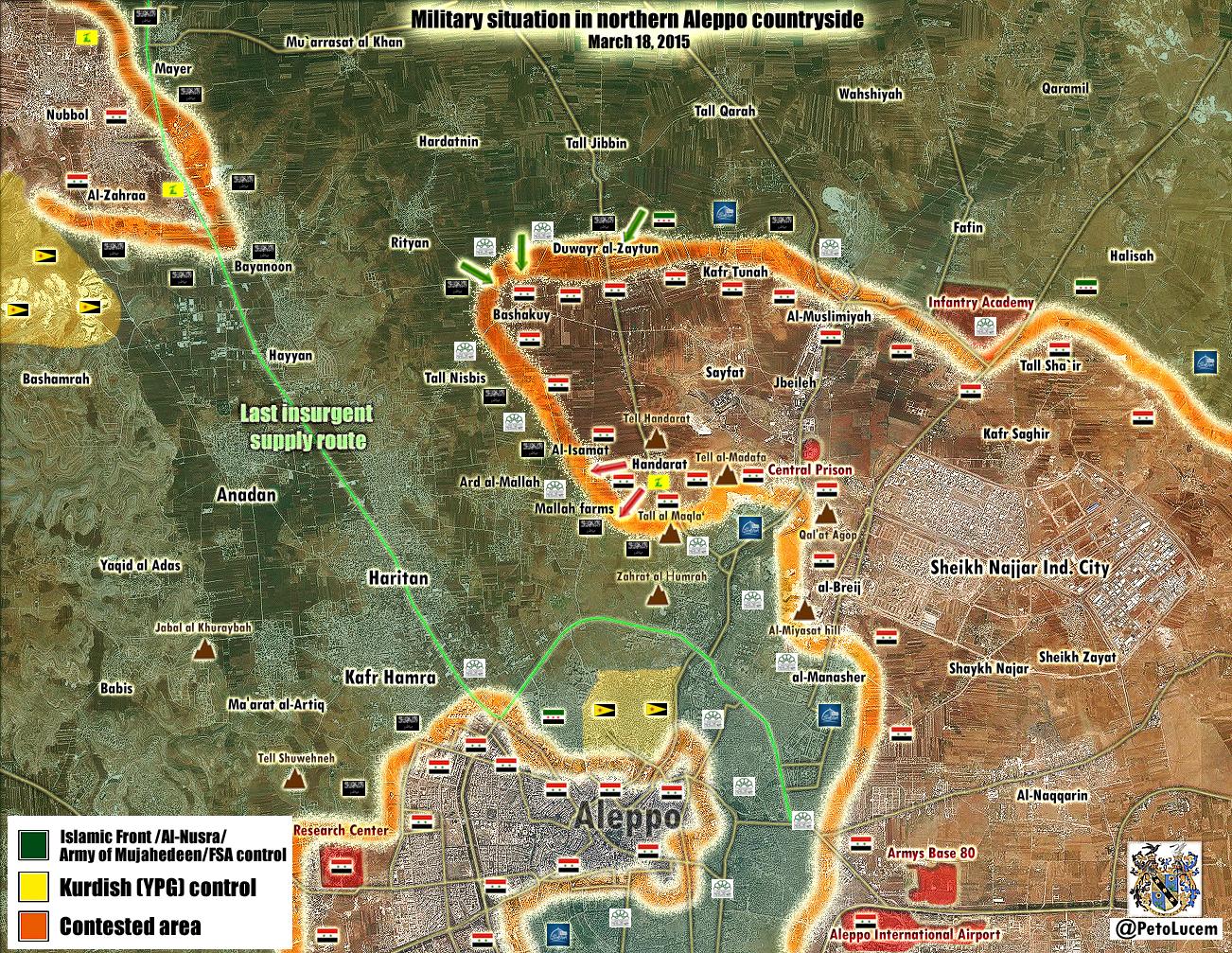
Nasrat & Hanash - Hasakah
Are there any sources on why these two towns were changed from SAA held here to IS held? MesmerMe (talk) 17:15, 15 March 2015 (UTC)
- MesmerMe Source:here Hanibal911 (talk) 19:52, 15 March 2015 (UTC)
- I think he wanted a real source, not a rather vague unannotated map ... André437 (talk) 09:12, 16 March 2015 (UTC)
- The same unnanotated map was used to expand govt holdings in the Khabur area from three into eight villages and to remove the shared YPG-SAA control from many areas in south Qamishli so in case we are going to revert these changes (which is a legit idea, Cetin never cites his sources) we should also revert govt control in the river to only Bab-al-Khayr and the other two close-by villages and restore most of the shared villages SE of Qamishli. 186.119.51.112 (talk) 17:26, 16 March 2015 (UTC)
- It is good neutral source that not biased to favor one side in this conflict.here Hanibal911 (talk) 09:18, 17 March 2015 (UTC)
- @ Hanibal911 That is not a source, that is an unannotated openstreet map from an unknown contributor apparently based in Russia.
- 1) Anyone can contribute anonymously to an openstreet map. I've done that for my local area.
- 2) Russia is a regime ally, in case you hadn't noticed.
- 3) You repeatedly claim that desyracuse is biased pro-rebel, despite no evidence of that, and his giving considerable detail to describe changes on his maps. But claim that this unknown map with no supporting descriptions is reliable. Try being coherent.
- 4) No map alone is sufficient to make ANY changes to a WP map. All changes are supposed to be documented, with reliable references, according to WP guidelines. A drawing by an unknown source is never a reliable reference.
- 5) So please do not use maps to make changes to our map André437 (talk) 02:40, 19 March 2015 (UTC)
- André437 Firstly I dont know why you think that it is a Russian source. Secondly we can said that it is partialy pro Kurdish source but it is clear not pro government source. Also he showed success by ISIS. Also many source confirmed that Syrian troops captured many villages on road to the town of Tall Brak.Al AkhbarAl Jazeera Also about Russia here I agree with you that this country is a supporter of the regime but also some EU countries and the United States including some Middle East countries such as Qatar and Saudi Arabia and Turkey supported of rebels but we are use their sources for display success by rebels. My country also supports the moderate opposition. I also fully supports of the moderate rebel in their fight against terrorists from ISIS. But in fight rebels against regime I try to be neutral editor. Also the most of the same villages that was marked as under control of the Kurds and the Syrian army to the south from the city of Qamishli also marked as under their control on the pro opposition map from deSyracuse.deSyracuse Also this source which made this map also some times use pro opposition sources. Here this source used data from biased pro opposition source of archicivilians for editing the map which showed situation inside city of Hasakah. When was clashes between Syrian troops and Kurds.here Also if you look this source used data from many sources so we cant said that this source pro regime or unreliable. He not opposes against not one of the parties in this conflict. Hanibal911 (talk) 08:19, 19 March 2015 (UTC)
- André437 Also if this guy which made those maps from the Russian or he Russians this not mean that he support Syrian regime because it is not Russian official source also in my city live many people from Russia and some from their against Syrian regime but supported rebels and in Russia some people also support Syrian opposition. Hanibal911 (talk) 08:30, 19 March 2015 (UTC)
- Hanibal911 But WP policy says we need documentation to support changes. Not counting additional requirements for our page. A map without supporting information is just a drawing, not documentation. And anyone can make a drawing. It may coincide with the situation on the ground, but without clear references, there is no way to confirm it.
- So unannotated maps are NOT acceptable for changes to our map.
- However desyracuse maps come with documentation (on the link with comes with all twitter posts.) So depending on the info provided, we can use desyracuse posts. Based on the info that comes with the map. Some maps have annotations with dates and places, they could be used.
- Of course this also depends on reliability, the clairity of the info and assumed bias.
- For images that can be verified by geolocation, that can be good if the time frame is reasonable. (For instance, Euphrates volcano (kurd/fsa) images in areas previously long controlled by Daesh.)
- For other types of information, subject to the reliability of the source, there is also the consideration of bias. Following WP guidelines, a claim of gains by a party to the conflict is not adequate. By this, for example, Almasdar, which simply quotes regime reports, cannot be used for any changes favourable to the regime. Similarly for reports that come from rebel, Daesh, or YPG sites, for changes that favour that party. This would include gains of any party to the conflict against Daesh, if not supported by objective evidence.
- However we have an additional rule for our page : a source which is biased in favour of a party to the conflict cannot be used for changes of gains for that party. Here the problem is determining bias. According to WP guidelines, just because an independent source would prefer a certain outcome, doesn't mean that reports from that independent source is biased in their reporting. And it is the bias in reporting that counts.
- That is why SOHR has long been accepted as an unbiased source. They report, to the best of their knowledge, what actually happens on the ground. It doesn't mean that they report everything, or that it is always accurate, because like any other source, they can't possibly know everything that happens.
- There is also a WP guideline that, where possible, tertiary sources be preferred. That is, sources that analyze reports from independent sources. This is where desyracuse reports can be useful, since he is a tertiary source. As well, he reports info from both neutral, pro-rebel, and pro-regime sources. I see no sign of bias in his reports.
- We should analyse each report of whatever source according to the above criteria. As well as is the information provided sufficient to support the proposed changes to the map ?. On this last point, the recent regime offensive north of Aleppo never succeeded in establishing control, and the regime ended up losing territory in the counter offensive. Yet many editors were prematurely claiming that the regime had made (sustainable) advances. We have to be more careful about this.
- Anyway, I know you're trying to do your best. André437 (talk) 11:36, 19 March 2015 (UTC)
Handarat
According to SOHR SAA recaptured full of handarat http://www.syriahr.com/2015/03/%D9%82%D9%88%D8%A7%D8%AA-%D8%A7%D9%84%D9%86%D8%B8%D8%A7%D9%85-%D9%88%D8%A7%D9%84%D9%85%D8%B3%D9%84%D8%AD%D9%8A%D9%86-%D8%A7%D9%84%D9%85%D9%88%D8%A7%D9%84%D9%8A%D9%86-%D9%84%D9%87%D8%A7-%D9%8A%D8%B3/Hwinsp (talk) 11:55, 18 March 2015 (UTC)
Peto Said the Army controlled it https://twitter.com/PetoLucem/status/578107389515190273
If it's 100% confirmed the Offensive staring in February no were at fail after all despite the heavy losses --LogFTW (talk) 14:56, 18 March 2015 (UTC)
- This also confirmed pro opposition sources.herearabthomnessdeSyracuse Hanibal911 (talk) 19:58, 18 March 2015 (UTC)
- The Syrian army backed by militia took Handarat after 10 days of fierce fighting with Nusra and other Islamist brigades.The Daily StarReutersAn NaharYahoo NewsLycos News Hanibal911 (talk) 22:07, 18 March 2015 (UTC)
- @ LogFTW Before the regime offensive in February, the regime held Handerat and the hills south of it. In the rebel counter-offensive, the rebels captured that and other territory held by the regime before. The regime is far from re-capturing all the territory lost, so indeed, the regime offensive in February was a failure. Without the foreign armies fighting the Syrian rebels, the regime wouldn't have been able to recapture what they did. André437 (talk) 01:42, 19 March 2015 (UTC)
Bashkuy in North Aleppo were captured by the Army in February 2015 a location who the beheaders taken in 2012 - the Offensive no is fail at all yet because it continue at the moment --LogFTW (talk) 05:10, 19 March 2015 (UTC)
- André437 But let's be fair and recognize that among the rebels also a lot of mercenaries from other countries and not just the Syrians. Hanibal911 (talk) 07:36, 19 March 2015 (UTC)
- Hanibal911 Agreed that there are foreigners fighting on the rebel side, especially jihadist groups like Nusra, although generally not a very large portion. And Daesh, another party to the conflict, is a foreign force from Iraq, with a large element of former members of Sadaam Husein's army, as well as a high percentage of foreigners.
- However the regime is using formally trained foreign armies, unlike the rebels. As well as being a considerably greater portion of regime forces than that of the rebels. Note that except maybe the elite iranian forces, these are recruited as mercenaries, paid to fight for Assad. Foreigners fighting on the rebel side aren't mercenaries. André437 (talk) 11:54, 19 March 2015 (UTC)
- I agre with you 100% Angre in the firsty paragraph, most ISIS important men are Iraqui Era soldiers, despite MSM label them as a Western-Become-Musslim Army. However how you know Iranians are paid and rebels not?Mr.User200 (talk) 12:50, 19 March 2015 (UTC)
- Syrian troops backed by non-Syrian militiamen and Hezbollah have took control on al-Madafa hill and a farm around Hendarat after loosing control on it for more than 10 days after violent clashes against rebel and Islamic battalions backed by al-Nusra.SOHR Hanibal911 (talk) 14:17, 19 March 2015 (UTC)
Syrian forces take control of Madafa hill near Handarat as well as a farm near it [21].Daki122 (talk) 14:16, 19 March 2015 (UTC)
Also Andre just to remind you that almost all of the fighters that were killed on the regime side were locals from Aleppo while the rebels in the area have whole units made up of foreigners like the Uzbek unit that is fighting there.Most of the foreigners in the Regime forces are Hezbollah fighters or Iranian backed fighters who are in very small numbers that can be seen in the latest statistic where foreigners killed on the rebels and ISIS sides are 10 times more than those on the government side.Daki122 (talk) 14:32, 19 March 2015 (UTC)
Syrian troops launched a counteroffensive in Aleppo
- Syrian troops recaptured the village of Handarat.SOHRThe Daily StarReutersAn NaharYahoo News
- Syrian troops backed by non-Syrian militiamen and Hezbollah have took control on al-Madafa hill and a farm around Hendarat after loosing control on it for more than 10 days after violent clashes against rebel and Islamic battalions backed by al-Nusra.SOHR
- Pro opposition source also confirmed that Syrian troops recaptured Nuqat al-IsamatHalabi Farms and now there are clashes in al-Mallah Farms and at the entrance the village of Ard al-Mallahhere Hanibal911 (talk) 19:32, 19 March 2015 (UTC)
Semi-protected edit request on 19 March 2015
This edit request to Module:Syrian Civil War detailed map has been answered. Set the |answered= or |ans= parameter to no to reactivate your request. |
Apparently Al Kafat in Hama Province has been taken by FSA/Nursa according to this article http://syriadirect.org/main/30-reports/1930-jabhat-a-nusra-fsa-seek-to-break-regime-cordon-in-homs in addition to the unmarked (on this map) Zur a-Sous air defense base. 162.220.45.98 (talk) 18:06, 19 March 2015 (UTC)
- It is just data from biased pro opposition source which we cant use for displayed success of rebels. Hanibal911 (talk) 18:23, 19 March 2015 (UTC)
- Also according to data from pro opposition map this town located deep in area which under control by Syrian troops.here So need confirmation from neutral source. Hanibal911 (talk) 18:39, 19 March 2015 (UTC)
- Also SOHR just said that clashes are taking place between the regime forces and Islamic factions near the village of al- Kafat in the countryside of al- Salameyyah after by detonating a booby- trapped vehicle near a regime position.SOHRSOHR But SOHR not said that the rebels captured something in the area. Also in this Syria Direct source just said that the Abu Abdu a-Shami spokesman for Jabhat a-Nusra said that al Nusra liberated the town of Kafat in the east Hama countryside and the Zur a-Sous air defense base.official Al Nusra source So we cant use this data. Hanibal911 (talk) 18:53, 19 March 2015 (UTC)
- Also pro government NDF source just said that NDF destroyed two car bombs which trying to target a checkpoint outside the town of Al Kafat.here So for now we have conflicting data. And SOHR justa said about clashes between Syrian troops and Islamic factions near the village of al- Kafat after by detonating a booby trapped vehicle near a regime position.SOHRSOHR Hanibal911 (talk) 19:18, 19 March 2015 (UTC)
- Also SOHR just said that clashes are taking place between the regime forces and Islamic factions near the village of al- Kafat in the countryside of al- Salameyyah after by detonating a booby- trapped vehicle near a regime position.SOHRSOHR But SOHR not said that the rebels captured something in the area. Also in this Syria Direct source just said that the Abu Abdu a-Shami spokesman for Jabhat a-Nusra said that al Nusra liberated the town of Kafat in the east Hama countryside and the Zur a-Sous air defense base.official Al Nusra source So we cant use this data. Hanibal911 (talk) 18:53, 19 March 2015 (UTC)
- Also according to data from pro opposition map this town located deep in area which under control by Syrian troops.here So need confirmation from neutral source. Hanibal911 (talk) 18:39, 19 March 2015 (UTC)
- Certainly not enough to say taken by the rebels, so answered "no".
- Some other reports say clashes, or rebels only in surrounding countryside. If you think there is enough info, should we mark it as contested or besieged-one-side ? André437 (talk) 09:08, 20 March 2015 (UTC)
- Later the pro opposition source said that the alawite militias recapture most areas including Kafat (mainly an alawite populated village).Syrian Rebellion Observatory(Cédric Labrousse) Hanibal911 (talk) 21:09, 20 March 2015 (UTC)
Semi-OT: Hasakah 2015 offensive article.
This wikipedia article: http://en.wikipedia.org/wiki/Al-Hasakah_offensive_%28February%E2%80%93March_2015%29
According to it 100 Hezbollah soldiers are fighting in Ras-al-Ayn/Serekaniye area with a very biased (pro-opposition and anti-PYD) source being quoted, which I assume goes against WP policies:
Could anyone revert that if it's not much of a problem? I would do it myself but I have no idea how to do it, thanks in advance.
Edit: The apparently original report in twitter, two days prior to thiqah1: https://twitter.com/abedalazez_kh/status/577579615486652416
Again, pro-opposition source.
186.112.207.201 (talk) 19:33, 20 March 2015 (UTC)
- Changes proposed for another WP article should be done on the talk page for that article.
- Then you could put a link to that proposed change here if you like.
- Although, in passing, I agree that Hezbolla forces supporting the YPG seems improbable.
- As for reverting a change, click the history button at the top of the page in question, use the comparison feature to locate the related post, then click the revert option, enter the reason why, then save.
- You might have to use an account to do this, as is the case here. It depends on the policy for the page. André437 (talk) 02:43, 21 March 2015 (UTC)
- Done it. We have WP:RS policy, I will not even discuss it. EllsworthSK (talk) 18:19, 21 March 2015 (UTC)
- Thanks André for the very detailed answer, despite Ellsworth doing the change (thx too) I will take it into account next time something similar happens, regards. 186.112.207.201 (talk) 23:18, 21 March 2015 (UTC)
Sarrin
Pro opposition source reported that YPG backed by allies stormed the town of Sarrin the last stronghold of ISIS in Kobane countryside.ARA News Hanibal911 (talk) 12:47, 20 March 2015 (UTC)
- 8fra0 Because moderate rebels and Kurdish troops jointly fight against ISIS not correct use the pro opposition source to display success of Kurds. Also it it very importent of strategic town and maybe we need wait more confirmations this data from neutral sources. So maybe you hastened mark it as contested. Hanibal911 (talk) 15:12, 20 March 2015 (UTC)
- 8fra0 Also another source said that ISIS still holds Grain Silos and depot near Sarrin amid heavy clashes.Jack Shahine also another pro Kurdish source just reported that YPG took control of farms in west of Sarrin but small clash. ISIS abandoned HQ.here So that probably the town of Sarrin still under control of ISIS and YPG for now only prepare attack against this town. Hanibal911 (talk) 15:25, 20 March 2015 (UTC)
- 1) Hanibal911 and others : just a suggestion, but could you use something more specific than "pro-opposition" ? Like pro-rebel (which could include the kurds), pro-kurd, pro-ISIS (Daesh), etc.
- Note that the regime is also in "opposition" to all the other groups. André437 (talk) 00:19, 21 March 2015 (UTC)
- 2) The Aranews report cites kurd/FSA military saying that Sarrin is contested, so we need to await confirmation.
- The twitter post claiming Daesh taking control of some farms west of Sarrin and abandoning HQ in Sarrin, is not detailed enough to be useful. Whatever the supposed reliability of the source. (Daesh could have escaped Sarrin to these farms, or could still control most or all of Sarrin.) André437 (talk) 00:19, 21 March 2015 (UTC)
- 8fra0 Also here reliable source said that it was all are false news that YPG entered in Sarrin he said that ISIS still holds Grain Silos and Depot to north from Sarrin and YPG/FSA jointly forces not entered in the town.Jack Shahine Hanibal911 (talk) 07:28, 21 March 2015 (UTC)
- Yes, I've just seen Jack Shahine tweet. I don't know why but sometimes Aranews publishes fake/fabricated news, we shouldn't use it anymore as a source. --8fra0 (talk) 15:51, 21 March 2015 (UTC)
- All the rumors that YPG getting closer to the town of Sarrin east of the Euphrates River south of Kobani are false.here Hanibal911 (talk) 16:33, 21 March 2015 (UTC)
- While Jack Shahine is at least in Kobane, the "Independent Journo" is just a bloke who copy-cats ISIS statements or twitter feeds. Not sure why should we devout any sort of attention to him. EllsworthSK (talk) 18:25, 21 March 2015 (UTC)
- Agree on the "Independent Journo" Twitter account. It's an "ISIS fanboy" account which is wildly unreliable in my experience. Ryn78 (talk) 20:43, 21 March 2015 (UTC)
- @Hanibal911 You should check out sources a little before using them.
- As noted by others, "Independent Journo" is a very virulent pro-Daesh/ISIS site with no evidence of substance. If anything, his denial of rebel presence in Sarrin suggests the contrary.
- Please, in future do a little investigation and analysis of your sources. Thanks André437 (talk) 06:12, 22 March 2015 (UTC)
- No such claim from YPG Kobane or general command. EllsworthSK (talk) 18:23, 21 March 2015 (UTC)
- Chuck Pfarrer's latest map (released just minutes ago) shows Sarrin still held by ISIS: [22] Ryn78 (talk) 22:19, 21 March 2015 (UTC)
- Although he also says he has had reports that the YPG has taken the police station in Sarrin: [23] Ryn78 (talk) 23:10, 21 March 2015 (UTC)
- I'm fairly sure we've said we're not using maps as reliable sources, but there could be something to look for in reliable sources. Banak (talk) 04:22, 22 March 2015 (UTC)
Status of the villages around Tal Tamir
YPG has released a video https://www.youtube.com/watch?v=HftY6euObro (at 1:00) which has been clearly shot inside the Grain and cotton depot of Ghabshah here: http://wikimapia.org/#lang=en&lat=36.652135&lon=40.354886&z=16&m=b Hardly IS controls fully Ghabshah, as the depot is a mere 200 metres from the proper village. For sure I would remove the west-besieged icon from Tal Tamir. --8fra0 (talk) 12:02, 18 March 2015 (UTC)
- I agree. The video is clear. Just outside the silos. (Looks like the north side.)
- In addition to the soldier speaking, there are a number of others around casually, out in the open. They wouldn't have that demeanor if Daesh were close. André437 (talk) 02:21, 19 March 2015 (UTC)
- I have to correct myself (I was distracted by the title of the video telling about Tal Tamir). There is another cotton depot south of Manajir which is almost identical to the other one, but with some details (roofing, buildings around) which best fit with the YPG video. So the video has been shot south of Manajir here: http://wikimapia.org/#lang=en&lat=36.678419&lon=40.192722&z=19&m=b . So nothing can be said about Tal Tamir, but on the other hand I see that also Manajir has been marked as besieged, and the nearby village Al Ahras, near the depot, marked as IS controlled. --8fra0 (talk) 07:10, 19 March 2015 (UTC)
- That explains why it was a little hard to tell which side of the silos. Close to identical structures, but this one matches. The video was taken on the west side of these silos, which are just to the west of Manajir. So it looks like Manajir is no longer besieged from the west. Al Ahras is about 800m to the south. André437 (talk) 12:26, 19 March 2015 (UTC)
- I dont agree.When have we start using amateur videos also pro-side sources against another side? Lindi29 (talk) 14:55, 19 March 2015 (UTC)
- Agreed with Lindi29 We cant use Kurdish amateur video for displayed success of Kurds. Because according to the rules of editing we cant use the pro Kurdish source for displayed success of Kurds. Hanibal911 (talk) 15:02, 19 March 2015 (UTC)
- Also SOHR confirmed about that video being reliable: http://syriahr.com/en/2015/03/ypg-fighters-seize-an-armored-vehicle-and-kill-7-is-militants/ . So it can be used for sure, if one can find the exact place where it has been shot (and this is the case: in south-west Manajir). 8fra0 (talk) 17:49, 19 March 2015 (UTC)
- Lindi29 Hanibal911 Please everyone, objective analysis of the evidence.
- 1) So-called "amateur videos" can be the most reliable evidence, if they can be verified, by factors such as geolocation. Much more reliable than an article in a major western news source, which depends on we-don't-know-what. The expression "amateur video" is just a trick to denigrate potentially valuable information.
- 2) The question of pro-rebel|Daesh|regime only comes into play if we cannot otherwise validate the information.
- 3) In this case every detail in the video exactly matches the silos and the surrounding area. Including the roof and relative location and size of the adjacent shelter, other adjacent building in the video, the surrounding ground surface, etc. No room for doubt by any intelligent observer.
- 4) All information should be analyzed before being accepted to change our map. The idea that everything from a "reliable source" is automatically the truth is a fallacy. The best of sources can make mistakes, and even the worst of sources often tell the truth.
- Images tend to provide the most reliable information, and although maps tend to summarize other info, they should never in themselves be considered reliable. In between we find other types of info, such as from major news sources. André437 (talk) 08:59, 20 March 2015 (UTC)
- I absolutely agree, too often here maps made by authors without any reference/proof of reliabilty are used as a source. One could create a twitter account, make his beautiful map, tweet it and use his own map as a source here in Wikipedia. --8fra0 (talk) 00:42, 21 March 2015 (UTC)
- André437I dont agree beacause this are pro-side sources which are not confirmed,also SOHR confrims the videos after it has confirmed the story.We also have many videos sources from rebels but nobody used them,but why didn't we use them beacause we have to many pro-side editors specially from Regime Faction and Kurd Faction and they always rejected rebels and jihadis videos calling them fake but if one amateur videos showed up from pro-side sources from the regime or kurd advancing they always made it a big news,but editors like you,Hanibal911 and others who are neutral i understand but in this case I am suggesting to raise a new Issue for amateur videos?Lindi29 (talk) 12:36, 21 March 2015 (UTC)
- We have long agreed not to use amateur video as a source because it is very difficult to verify when it was filmed. Also we can not use the video from the pro-government TV stations to display the progress of army and also we cant used to display success of rebels video from pro opposition sources. And the same applies to pro Kurdish and pro ISIS sources. In this rule, there should be no exceptions. We can use the video if the data from this video confirmed reliable sources. So that let's follow the rules of editing. So how pro government or pro Kurdish or pro opposition and pro-ISIS sources very often distort the evidence in favor of one party in this conflict. Let's we will be the neutral when edit the map even if each of us support different sides in this conflict. Hanibal911 (talk) 13:50, 21 March 2015 (UTC)
- According to a local pro-govt source, clashes are happening in Tal Shamiran, Tal Nasr and Ghabsnah villages: https://www.facebook.com/HASAKAHNEWS/posts/718946824893160 186.112.207.201 (talk) 02:30, 22 March 2015 (UTC)
- Pro-oppo Qasion News reports clashes in Tal Baaz, Tal Hormizd and Tal Fayda:http://qasion-news.com/en/content/isis-deaths-among-clashes-tal-tamr#sthash.FUh61gOS.03fPRtiQ.dpbs 186.112.207.201 (talk) 11:34, 22 March 2015 (UTC)
I accidentally read the date on a video as 2015 when it was dated on 2014. Please delete this.
This edit request to Module:Syrian Civil War detailed map has been answered. Set the |answered= or |ans= parameter to no to reactivate your request. |
Please ignore this. Video was from last year. 76.126.188.171 (talk) 08:52, 24 March 2015 (UTC)
- Have you seen that your video dated 23 March 2014. Hanibal911 (talk) 08:58, 24 March 2015 (UTC)
I just did, and I feel like such an idiot...
Sorry. — Preceding unsigned comment added by 76.126.188.171 (talk) 09:02, 24 March 2015 (UTC)
- It's okay everyone can make mistakes! This was in time of the rebels offensive in March 2014 2014 Latakia offensive but later army regained this territory.The New York TimesCNS NewsThe Daily StarAssociated Press Hanibal911 (talk) 09:09, 24 March 2015 (UTC)
answered=yes since request withdrawn ... we all make mistakes ... thanks for letting us know :) André437 (talk) 10:47, 24 March 2015 (UTC)
al-Shaddadi
Two days ago pro opposition source reported that Revolutionaries targeted the eastern checkpoint of ISIS in al-Shaddadi area, which is one of the biggest and strongest ISIS checkpoints in the area, killing the eastern sector’s commander along with other militants. This is the first special operations after ISIS gained control of al-Shaddadi in al-Hasakah province.RFS Media Office Hanibal911 (talk) 17:28, 23 March 2015 (UTC)
- Also another one pro opposition source reported that after attacks in North Syria. A new brigade Jaysh al-Islam which dedicated fight against ISIS led an attack near al-Shaddadi in Hasakah province.Syrian Rebellion Observatory Also moderate rebels claim that they killed several ISIS fighters during an undercover operation in city of Shaddadi.here Also pro opposition source ARA News reported that the several leading members of the Islamic State group ISIS were reportedly killed in an attack by rebels of the Hayzoom Unit (linked to the Army of Islam) in the city of Shaddadi (60 km south of Hasakah) The military operation, described by the rebels as “strategic”, targeted a security checkpoint of the Islamic State in eastern Shaddadi, where a group of military commanders from the radical group were holding a meeting. The targeted checkpoint is considered the most highly equipped IS-led checkpoints in northeastern Syria. Khalil al-Hamidi, a local from Shaddadi, said that the attack led to the killing of Abu Mohammed al-Janoubi, “Emir of al-Qate’ ash-Sharqi” (prince of east Shaddadi), and the injury of Abu Mahmoud ar-Raqqawi, head of the security apparatus in the eastern areas (ah-Sharqiya).News Hanibal911 (talk) 18:06, 23 March 2015 (UTC)
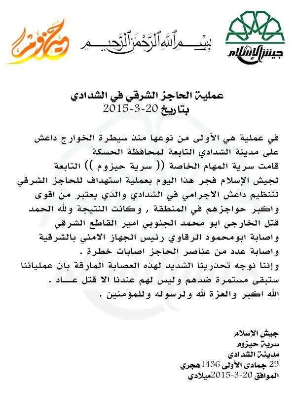
- Anti-ISIS insurgency is nothing really that new. Remember the break out in Manbij or the assassinations in Deir ez-Zor. But when it comes to map, I have serious doubts that presence of underground resistance / insurgent movement would qualify for contested dot on a map. EllsworthSK (talk) 00:14, 24 March 2015 (UTC)
- Agreed. André437 (talk) 11:04, 24 March 2015 (UTC)
Cease-fire
Pro-opposition source reported that an agreement about cease-fire was settled between FSA fighters in Al-Qadam and Al-Asaaly neighborhoods with regime under a cease-fire agreement in the area.Qasion News Hanibal911 (talk) 12:12, 24 March 2015 (UTC)
Talbiseh
Clashes are taking place between the rebel and Islamic battalions against the regime forces in the city of Talbisah in the north of Homs.SOHR But let's not rush to edit this city until we dont get more data because report maybe erroneous. Hanibal911 (talk) 08:01, 25 March 2015 (UTC)
Suwayda
In the last few days, rebels seem to have begun a large offensive around Bosra al-Sham and the Daraa-Suwayda border region. DeSyracuse has made a new map showing the situation, which can ben found here: http://www.agathocledesyracuse.com/wp-content/uploads/2015/03/South-Suweydaa-23-March-2015.png
According to this map rebels have advanced north and south of Bosra al-Sham. This would translate on this map to making green: Umm Walad, Jamrin, Khirbat al Mahara, Samj and Samad, and to making contested: Bakka, Barad, Zibin.
Your thoughts? — Preceding unsigned comment added by 84.24.43.183 (talk) 21:55, 23 March 2015 (UTC)
- DeSyracuse is a pro-opposition source and cannot be used for rebel gains. Sources like Al-Masdar have also denied any rebel advancement in the offensive, so for now it is best to wait for a neutral source to make a statement. XJ-0461 v2 (talk) 22:13, 23 March 2015 (UTC)
- Why was Bakka still edited as under attack? MesmerMe (talk) 01:42, 24 March 2015 (UTC)
- 84.24.43.183 Firstly deSyrcuse it is a pro opposition source and we cant use it data for displayed success by rebels. Also he just said that clashes between villages Bakka and Zibin also he is marked these villages Bakka, Barad, Zibin as under control by Syrian troops you need carefully see on map. And secondly without confirmation from a reliable source we cant marked as under control by rebels these villages (Umm Walad, Jamrin, Khirbat al Mahara, Samj and Samad) Hanibal911 (talk) 06:48, 24 March 2015 (UTC)
- Also SOHR and pro opposition source Documents.Sy just said that clashes between villages Bakka and Zibin and nothing more.SOHRDocuments.Sy Hanibal911 (talk) 06:55, 24 March 2015 (UTC)
- I wouldn't consider any map without annotations as more than a suggestion of what to look for.
- There is an annotation on the map which says that the regime still controls eastern Bosra al-Sham, so it keeps its' status of contested, since well over a year.
- Another annotation says a "raid" around Ashlihah, Suweida, which is not enough to change its' status.
- Yet another annotation says heavy fighting between Bakka and Dibbin. So maybe partial siege southwest of Bakka, northwest of Dibbin. We could wait for more info from this or other sources.
- The SOHR link by Hanibal911 discusses Hama, not this area, and the Syria Documents link says almost nothing. This last source rarely gives useful info on any clash.
- For other changes, I would favour waiting for explicit written confirmation, since the front lines are rarely as neat or hermetic as we might like. Otherwise we wouldn't have rebel leaders traveling by land from Daraa to meetings in Turkey. Desyracuse could well be making assumptions about the control of other points. (Even while trying to be objective.)
- A generally reliable pro-rebel source has posts saying that a media blackout has just ended, and that activists report that
- 1) the rebels took the main checkpoint east of Bosra, and
- 2) the road from Bosra to Suweida is cut for now.
- So we should keep an eye on developments around Bosra. Note that there is a small regime base just north-east of the town.
- Note that this source (Labrousse) in the past reported rebel advances in the south some months before SOHR noticed, and foreign media only noticed much later when a regime official complained publicly.
- BTW, I don't know why some editors keep saying that Desyracuse is "pro-opposition". Maybe because he is neutral and not "pro-regime" ? There is absolutely no evidence of bias by Desyracuse.
- As well, critical reading of Almasdar posts, cited by XJ-0461 v2, tell us that it is only echoing regime claims. Thus, Almasdar is not just pro-regime, it IS a regime source. Not surprising that the regime has not claimed rebel advances.
- We don't yet have enough info to make many changes . André437 (talk) 10:37, 24 March 2015 (UTC)
- Now the NDF has published a video claiming clashes outside Bakka village. So with this regime confirmation, we have enough info to put it at least besieged by southwest (according to Desyracuse map), if not contested. André437 (talk) 10:56, 24 March 2015 (UTC)
- André437I against the use of Al Masdar as a reliable source but dont need said that Syrian Rebellion Observatory (Labrousse) more reliable or that this source more reliable than SOHR because SOHR partialy support opposition but (Labrousse) on 100% biased pro opposition source which clear opposes against Syrian government so we cant use him data also many times we will agree that deSyracuse pro opposition source. So for now we have data from SOHR which we can use for displayed success for all sides in the Syrian war and not more. I see that XJ-0461 v2 completely supports by the Syrian troops and opposes Syrian rebels but you are André437 completely supports Syrian rebels and opposes by Syrian troops. So let's just wait for data from neutral sources about the situation in this area. But I ask both of you dont need to write great messages in try to prove who pro government or pro opposition sources are more reliable. Hanibal911 (talk) 11:37, 24 March 2015 (UTC)
andré you little snackbar lover. 1. Al masdar is not a regime source, the editor lives in the US and he has friends from SAA. There was biased posts there til 2014 but since months they are writing about fallbacks also. Still it is pro regime that's why it is not used here. 2. EVERYONE (except pro opposition supporters who are mostly paid are believing there's still "rebels" and "moderates") knows there are only beheader jihadists vs SAA. 3. Both desyracuse and labrousse are 100% biased with markito and their delusional "reliable activists" who made the bullcrap Aleppo map 2 weeks ago claiming whole Handarat, Duwar zaytun was taken meanwhile 2 buildings on the outskirts was taken, and ofcourse their freedom fighters are already attacking Aleppo central prison! they do this every time a "offensive" is launched like South aleppo half year ago, in Idlib, Quneitra etc and after 3 days everything is lost and beyond. Only obvious edits should be made with video evidence on both sides backed by neutral sources like Elijah. Most likely SAA reinfocements will arrive and nusrats will lose even what they held due to syrian air force and heavy artillery. — Preceding unsigned comment added by Totholio (talk • contribs) 11:25, 24 March 2015 (UTC)
- I updated map in this area. Hanibal911 (talk) 11:56, 24 March 2015 (UTC)
- @ Hanibal911 You say that "we" agree that Desysracuse is a pro-opposition source, so if your "we" says that the moon is made of green cheese, that means others are obliged to accept that as a fact ?
- It would be much more useful to your arguments if you could provide reasonable evidence of any bias by Desyracuse. Pointing out the occasional error is not adequate. Since he readily works with any other source to try to improve accuracy, there is every evidence that he does his best to be neutral. And has a very good track record. Note that I'm saying to take all maps only as a guide, but in his case accept as accurate the annotations on his maps, and comments in his articles. After analysis, of course. Admittedly this probably doesn't make a lot of difference in what we accept, since his reports are generally soon reported by other reliable sources.
- SOHR is pro-human rights, and is not a party to the conflict. Evidently the vast majority of and worst human rights violations come from the regime. However SOHR has a long track record of reliable reports, which is why it has been accepted as reliable. As the WP guidelines clearly say, just because a source would prefer a certain outcome (in this case the cessation of human rights violations) does not mean it is a biased source.
- As far as Labrousse, I agree that he is anti-regime, as well as very strongly anti-Daesh/ISIS. (The middle east is his area of specialty. If he weren't anti-regime, there would be something wrong with his value system.)
- He also tends to favour moderate or islamic rebels over jihadists like Nusra. However, of his many reports, very few have been shown to be mistaken, and particularly in the south (around Daraa), he tends to accurately report situations before others. So his preferences are clear, and they may influence his reports, but evidently very little. Note that his reports generally indicate if a situation change is stable or not. For instance, his last reports indicate that the road out of Bosra is cut by the rebels, "for now". Thus not yet stable, so we wait. We should analyse all reports like that.
- André437 (talk) 06:45, 25 March 2015 (UTC)
- Well, it looks like Labrousse was right again. All sorts of photo evidence of rebels in control of Bosra. A few examples. 1234 5 6 From the rebels, of course. As well as a video declaration also by the FSA-led Southern Front. (Which includes Ahrar al-Sham, now the biggest member of the Islamic Front.) But since Bosra is one of the most distinctive locations in Syria, the images are the strongest possible evidence. a little history
- Just in case you don't like the irrefutable evidence coming from the rebels, Charles Lister concurs. (He also notes that the rebels took about 12 checkpoints in Idlib city.)
- I'll let you people change the status of Bosra to rebel held. André437 (talk) 12:57, 25 March 2015 (UTC)
- André437 More reliable source SOHR just said that rebels seized 7 regime checkpoints but the regime forces retake 4 of them back.SOHR and you source Syrian Rebellion Observatory {Cedric Labrousse} and some other pro opposition sources just very exaggerated achieve rebels. So we cant use the data from biased pro opposition sources because firstly they are not reliable and distort the real situation and secondly, by the rules of editings, we can not use the pro opposition sources to show the success of the rebels. Also abiut situation in Bosra here the spokesman for the Southern Front of the rebel alliance, Maj. Isam Rayes, told that regime forces were holed up in the historical citadel in Busra and that he denying reports that the town had been taken.The Daily Star And please dont need to list all of what you have data from a pro rebel sources since we can not use them without confirmation from neutral sources. However, we noted the town of Bosra under rebel control on the basis of data from SOHR but put a red semicircle as according SOHR clashes is still going on the outskirts of this town. Still, your data is useful for that would researching data from both sides of this conflict. Hanibal911 (talk) 14:56, 25 March 2015 (UTC)
- Also SOHR just said that the clashes continued around many checkpoints for regime forces around city of Idlib.SOHR Hanibal911 (talk) 15:06, 25 March 2015 (UTC)