
Talk:Control of cities during the Syrian civil war/Archive 47
| This is an archive of past discussions. Do not edit the contents of this page. If you wish to start a new discussion or revive an old one, please do so on the current talk page. |
| Archive 40 | ← | Archive 45 | Archive 46 | Archive 47 | Archive 48 | Archive 49 | Archive 50 |
Semi-protected edit request on 23 April 2015
This edit request to Module:Syrian Civil War detailed map has been answered. Set the |answered= or |ans= parameter to no to reactivate your request. |
please 2601:3:3880:494:7DB4:C0C4:5251:502D (talk) 23:09, 23 April 2015 (UTC)
 Not done as you have not requested a change. Please mention the specific changes in a "change X to Y" format. --I am k6ka Talk to me! See what I have done 02:29, 24 April 2015 (UTC)
Editing with pro-side sources
I think that LightandDark2000 doesn't have a clue with what sources he is editing example here he is using a pro-side source, here,also he is editing without any sources to here.Lindi29 (talk) 17:17, 23 April 2015 (UTC)
- I agre with Lindi29 such actions break the rules of editing with which we all agreed dont use the pro government sources to show the success of the Syrian army (as well as the Kurds in the province of Hasaka where they co-operate with the army) and do not use all the anti-government sources to show the success of the rebels and ISIS in their fight against Syrian troops because these sources are openly opposed to the Syrian army (also dont use pro opposition sources to show the success of the Kurds in the province of Aleppo, where they collaborate with the rebels). And also we have agreed not to use the pro government sources (because pro government sources openly oppose the rebels) to show success of ISIS or Al Nusra in their fight against moderate rebels. Hanibal911 (talk) 17:55, 23 April 2015 (UTC)
- The maps originated from another site, which I have not yet found. Some of the information has been reported via other sources, but the ones I am using are the only ones I can find that provide regular updates. I believe that it is best to use the resources available, rather than squabble over a few controversial issues. If there are clear conflicting reports, I will always try to stick with the more reputable/neutral source. Best regards, LightandDark2000 (talk) 05:48, 24 April 2015 (UTC)
Sugar Factory
Pro-gov source report on the sugar factory amid fierce clashes,here.Lindi29 (talk) 19:01, 23 April 2015 (UTC)
- Lindi29 Just need put semicircle near this factory and nothing more. As we earlier made near Brick Factory which was attacked Al Nusra before they retreated.Latif HassanSyrian Rebellion Observatory. Hanibal911 (talk) 19:14, 23 April 2015 (UTC)
- Lindi29 But pro government source also indicated that the clashes in surroundings of this factory but not inside this factory.Leith Al-Halabi so for now not need any actions let us wait more data. Hanibal911 (talk) 19:25, 23 April 2015 (UTC)
- Hanibal911 OK,then put a semicircle near the factory.Lindi29 (talk) 20:05, 23 April 2015 (UTC)
- Also pro opposition source confirmed that the city of Jisr al-Shughur still under control by Syrian troops and that rebels and Al Nusra still located on distance of 3-4 km from the city.Conflict ReporterConflict ReporterConflict Reporter and another pro opposition source Cedric Labrousse also confirmed that the Jisr al-Shughur is still under regime control as rebellion forces took some checkpoints north, west and east to city.Syrian Rebellion Observatory and that rebels didn't take any real strategic objective as the offensive aimed to do. Qarmid battle turned to blood bath.Syrian Rebellion Observatory and regime Ghab plain defense line (despite Simaniyah defeat) is more strongest contrary to what was expected.Syrian Rebellion Observatory Hanibal911 (talk) 20:50, 23 April 2015 (UTC)
- Lindi29Rebels just shelling Sugar factory here so for now not need put semicircle but still need monitor the situation. Hanibal911 (talk) 21:00, 23 April 2015 (UTC)
- Hanibal911 shelling and clashes are confirmed by both sides so the semicircle is needed.Lindi29 (talk) 21:23, 23 April 2015 (UTC)
- I'm with a semi-circle but not more. The rebels are waging an important psychological war ever since their semi-successful counterattack in Aleppo in February. They claim victories before (if they) happen. Yesterday all rebel sources claimed the Qarmeed aka Brick factory was captured. Today we saw it shell rebel positions. Same goes for all checkpoints, bases etc. Waiting a few days is no problem considering the fluidity of the frontline. To be fair, rebels are winning the media war that's for sure. Regime media outlets are lacking in war coverage and loyalists are becoming more and more demoralized. ChrissCh94 (talk) 22:06, 23 April 2015 (UTC)
- That depends on what media war you are talking about. The international media war is in favor of the SAA. More people abroad than even oppose the rebels. However, you are correct about the domestic media war. The rebels managed to, very early, get their super weapon into the arena "SOHR". For almost 3 years, it was one of the only sources for events in Syria. Whether you were pro-opp or pro-gov, you read SOHR. This effect has lessened, but is still strong. The SAA also seems to be making the mistake of not even trying to wage a media war. If you look at the Deir-ez-zor front, you will see numerous videos by the SAA of weapons seized, positions taken, and dead ISIS fighters being dragged through the streets. I believe this to be one of the reasons why ISIS's media war in Deir-ez-Zor is a failure. Other than there, however, the SAA has not been active since their old strategy of "deny deny deny" failed. The rebels constantly post videos of their exploits, even if they are faked, giving the illusion of daily progress. That is why the rebels' most fervent supports are still confident in total victory. If the SAA wants to turn the tide, they THEMSELVES [not their loyalists] have to start making ISIS style propaganda videos. Show captured positions, weapons, and dead rebels. Make the SAA appear larger than life, this strategy worked great for ISIS and has been proven effective for Gen. Zahhridine in Deir-Ez-Zor. XJ-0461 v2 (talk) 22:54, 23 April 2015 (UTC)
- I'm with a semi-circle but not more. The rebels are waging an important psychological war ever since their semi-successful counterattack in Aleppo in February. They claim victories before (if they) happen. Yesterday all rebel sources claimed the Qarmeed aka Brick factory was captured. Today we saw it shell rebel positions. Same goes for all checkpoints, bases etc. Waiting a few days is no problem considering the fluidity of the frontline. To be fair, rebels are winning the media war that's for sure. Regime media outlets are lacking in war coverage and loyalists are becoming more and more demoralized. ChrissCh94 (talk) 22:06, 23 April 2015 (UTC)
- Lindi29 But pro government source also indicated that the clashes in surroundings of this factory but not inside this factory.Leith Al-Halabi so for now not need any actions let us wait more data. Hanibal911 (talk) 19:25, 23 April 2015 (UTC)
- ChrissCh94 Here pro opposition source but not such dreamer as a archicivilians clear showed that rebels shelled this factory from distance herehere So for now not need put semicircle. This pro opposition source clear showed that factory in area which still controled of army and rebels position to east from factory from where they shelled him. Hanibal911 (talk) 06:28, 24 April 2015 (UTC)
- I put grey semicircle near Manshara Checkpoint and green semicircle near Bshlamon Checkpoint that would show that the clashes in surroundings of the plant. Hanibal911 (talk) 07:48, 24 April 2015 (UTC)
- SOHR also reported that clashes near the city of Jisr Shughour.SOHR Hanibal911 (talk) 13:08, 24 April 2015 (UTC)
- I put grey semicircle near Manshara Checkpoint and green semicircle near Bshlamon Checkpoint that would show that the clashes in surroundings of the plant. Hanibal911 (talk) 07:48, 24 April 2015 (UTC)
Tall hamaka
No reason to put Tall-Hamaka green. We are back to take SOHR as the source of truth. Other sources no more partisan than SOHR states the opposite: https://twitter.com/PetoLucem/status/591614810837618689 and https://twitter.com/IvanSidorenko1/status/591612029724663810. Just let's put it contested and wait.Paolowalter (talk) 15:23, 24 April 2015 (UTC)
according to sohr arabic ,saa recaptured tall hamaka http://www.syriahr.com/2015/04/%D8%A3%D9%83%D8%AB%D8%B1-%D9%85%D9%86-44-%D8%BA%D8%A7%D8%B1%D8%A9-%D8%B9%D9%84%D9%89-%D9%85%D8%AD%D9%8A%D8%B7-%D8%AC%D8%B3%D8%B1-%D8%A7%D9%84%D8%B4%D8%BA%D9%88%D8%B1-%D9%88%D8%A7%D8%B3%D8%AA%D8%B9/176.42.119.155 (talk) 16:08, 24 April 2015 (UTC)
Khalkhalah air base under seige
ISIS appears to have this base under seige following its recent assault there: IS jihadists 'down regime aircraft in south Syria' Nulla Taciti (talk) 15:48, 24 April 2015 (UTC)
- Source just said that ISIS shut down aircraft the Syrian aircorce and that according to data from SOHR the fate of crew members remains unknown. Source also said that ISIS tried to storm the airport on 11 April but loyalist forces maintained control of it.The Daily Mail Also early reliable source also confirmed that when ISIS attacke Syrian troops counterattacked and pushed bask ISIS. Here earlier several reliable sources confirmed that the Syrian troops repelled an attack on a key Syrian airport during a fierce battle in which they lost 20 fighters but killed almost as many militants, activists said. Rami Abdel Rahman, the head of the SOHR said there was an attack on the outskirts of the Khalkhalah military airport in Sweida province but the army has been able to maintain control over the airport and its surrounding areas despite losing 20 fighters. At least 15 militants were killed. Although the Observatory was awaiting confirmation on the identity of the attackers, Abdel Rahman told AFP they were likely to have been jihadis from ISIS.The Daily StarThe Malaysian InsiderNaharnetAgency France PressThe Economic TimesKhaleej Times You need carefully read your source before making statements. Hanibal911 (talk) 16:14, 24 April 2015 (UTC)
- Not exactly sure what you are saying Hanibal911. The fact that ISIS has positioned themselves outside the airbase and is apparently downing aircraft at their leisure would suggest an update to the map might be in order, although I'm happy to wait for additional sources. Nulla Taciti (talk) 16:25, 24 April 2015 (UTC)
- Nulla Taciti Any fighter from ISIS could shot down the Syrian Aircaraft from long diastance so this not confirm that ISIS also located near airport and even more so that he in the siege of ISIS. And many reliable source clear said that later troopp pushed ISIS from area near airport and surrounding area. And that for now ISIS not located near this area. So your data even indirectly not indicates that the airport is surrounded by ISIS. Hanibal911 (talk) 16:45, 24 April 2015 (UTC)
- Not exactly sure what you are saying Hanibal911. The fact that ISIS has positioned themselves outside the airbase and is apparently downing aircraft at their leisure would suggest an update to the map might be in order, although I'm happy to wait for additional sources. Nulla Taciti (talk) 16:25, 24 April 2015 (UTC)
Hudhud SAA held ?
Is the town of Hudhud east of Manjib really SAA held ? and if so how did they get there as all places around are ISIL held .Can someone explain thankyou .86.178.97.133 (talk) 16:39, 24 April 2015 (UTC)
- 86.178.97.133 Here is the editor without any foundation noted this village under the control of the army.here It is unjustified action that violates the ruleы of editing. Hanibal911 (talk) 16:50, 24 April 2015 (UTC)
Eastern Ghouta
Guys I don't know why Mayda'a and Zebdin are marked as regime held. SAA forces pushed into them but retreated via loyalist sources showing them under rebel control ever since their summer offensive: [1] [2] [3] [4] I could not find newer sources partly because it has been a calm frontline. ChrissCh94 (talk) 22:22, 23 April 2015 (UTC)
- Mayda'a was from SOHR, but Zebdin is only partly controlled by the SAA, but no one has fixed it since. I do not know how to. XJ-0461 v2 (talk) 00:18, 24 April 2015 (UTC)
- ChrissCh94 They both contested. Hanibal911 (talk) 05:51, 24 April 2015 (UTC)
Contested perhaps, but not regime held, change it to contested then. — Preceding unsigned comment added by 177.157.18.68 (talk) 10:26, 24 April 2015 (UTC)
- I agree either contested or rebel-held but definitely not regime held. ChrissCh94 (talk) 17:42, 24 April 2015 (UTC)
- ChrissCh94 I ask editor which updates maps and he update map and mark these towns as contested. Although now he busy but he updat map later. I necessarily remind him about this! Hanibal911 (talk) 18:01, 24 April 2015 (UTC)
- Hanibal911 Thank you! ChrissCh94 (talk) 19:02, 24 April 2015 (UTC)
- ChrissCh94 I ask editor which updates maps and he update map and mark these towns as contested. Although now he busy but he updat map later. I necessarily remind him about this! Hanibal911 (talk) 18:01, 24 April 2015 (UTC)
- I agree either contested or rebel-held but definitely not regime held. ChrissCh94 (talk) 17:42, 24 April 2015 (UTC)
Rebel Hama/Idlib offensive
Section for questions and request of changes DuckZz (talk) 21:36, 24 April 2015 (UTC)
ISIS counterattack in Sarrin countryside?
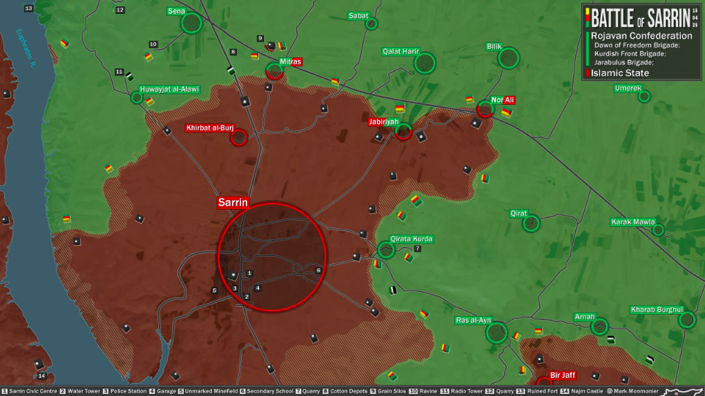
May be someone has a data from neutral sources about situation around city of Sarrin. Becasue a pro Kurdish sources reported that they advanced and captured several villages. But pro ISIS source reported that ISIS launched counterattack and recaptured villages of Qerat,Ra's Al 'Ayn, Erna and Kark.hereGeneral Shami Hanibal911 (talk) 16:40, 23 April 2015 (UTC)
Was just about to ask the same thing, because Pro-Kurd sources are also contradicting themselves on the grain silos, and where YPG forces are stationed. Some say the silos are taken, others say IS repulsed the assault despite airstrikes, and others are saying they are fighting in Sarrin itself, others say they are being pushed back by IS counter-offensive. I think what is going on is that because both sides are thin on forces there, small units on both sides are punching each other at the same time as IS moves up fresh company sized forces to replace fought out units and atritt YPG and hit their smaller detachments with maimum force while Airstrikes hit largely vacated positions. Similar to what the NVA did Tgoll774 (talk) 16:53, 23 April 2015 (UTC)
https://pbs.twimg.com/media/CDSSbkVUkAAeAcZ.jpg Chuck Pfarer a pro-YPG source, but yesterday he said YPG took the silos, now he has backtracked. https://twitter.com/freelancejorno/status/591352696990466049/photo/1 Pro-IS saying IS has successfully counter-attacked. I don't see any other sources so I can't say what is going on, but its pretty clear heay fighting is going on and YPG backtracked on saying they captured the silos. https://twitter.com/mrasiell/status/591337540088700929 Pro-IS Source. Don't know at this point, just going to have to see what other sources come up. But it looks like with Tishrin Secured, the YPG have hit the limits of their advance. Tgoll774 (talk) 21:54, 23 April 2015 (UTC)
https://pbs.twimg.com/media/CDTtgO6UgAAWAeF.jpg Pro YPG source, but admits Khirbat al-Burj and Qirat Kurdan, as seen on the map as retaken by IS, Ras al-Ayn looks contested. Tgoll774 (talk) 02:38, 24 April 2015 (UTC)
https://pbs.twimg.com/media/CDdoE0SXIAAFxZw.png:large Pro-Kurd
https://twitter.com/mraseill/status/592025037038837760/photo/1 Pro-IS
https://pbs.twimg.com/media/CDdi9O2UsAAP3h5.jpg Pro-Kurd
Leave it to you guys to cross reference Tgoll774 (talk) 20:36, 25 April 2015 (UTC)
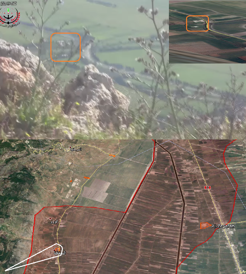
YPG advance south of Manajir
According to their official media they captured three hills south of the town:
This is confirmed by SOHR so we could make the change (northwest Tal Tamr = Manajir):
Problem is, no source actually mentions the name of the hills, does anyone know where they are located?
186.112.206.36 (talk) 15:39, 26 April 2015 (UTC)
Map update
It seems like the map (Module:Syrian Civil War detailed map/doc) doesn't always update immediately after an edit of the module. To make the map update, just make an Wikipedia:Null edit of the documentation page. --Ahmetyal (talk) 12:35, 26 April 2015 (UTC)
- Does purging not work? Banak (talk) 22:12, 26 April 2015 (UTC)
Jisr ash-Shughur has fallen under Jaysh al-Fatah control.
Or at the very least, is being contested. I have no idea whether it should be listed as Green or Grey, since both Jabhat al-Nusra and Ahrar ash-Sham are operating in/around this area.
https://twitter.com/IvanSidorenko1/status/591860301055700993 (pro-Gov source showcasing JaF in Jusr ash-Shughur
http://i.imgur.com/aV7yzto.png (picture from pro-Rebel source showing list of conquered buildings)
https://twitter.com/AFP/status/591869301663010819 (AFPfr claiming that the city has fallen outright to JaF)
- Al Nusra and several Islamist factions control large parts city of Jisr al-Shughour troop still control hospital SOHR and pro opposition source confirmed that Syrian troops still control hospital and the area on southern outskirts of the city here Hanibal911 (talk) 07:55, 25 April 2015 (UTC)
- And remember that Ivan Sidorenko not pro government source he just publish data from some sources pro opposition and pro government. And SOHR clear said that Al Nusra and several Islamist factions control large parts city of Jisr al-Shughour. And your source Agence France-Presse also said that Al Qaeda and allies overrun city of Jisr al-ShughurAgence France-Presse not only rebels. And pro opposition source confirmed that army still control hospital on outskirts. Hanibal911 (talk) 08:05, 25 April 2015 (UTC)
- Again as I said in the first post. At the very least, this city is contested. — Preceding unsigned comment added by 76.126.188.171 (talk) 08:32, 25 April 2015 (UTC)
- 76.126.188.171 I marked the city under the control of Al Nusra and insurgents, and added the hospital which under control of the army. And reliable sources and SOHR reported that Al-Nusra Front and its allies took control of almost all the city.Al ArabiaAgence France-Presse And this confirmed that at least hospital still controled Army. Nevertheless, I marked city under control by Al Nusra and rebels. Hanibal911 (talk) 08:55, 25 April 2015 (UTC)
- And pro opposition sources also said that Al Nusra and rebels captured largest part of city. But also pro opposition source also confirmed that for now the National Hospital it is the main stronghold of Syrian troops in Jisr al-Shughour.here Hanibal911 (talk) 09:09, 25 April 2015 (UTC)
- SOHR said clashes are still continuing in some pockets of Syrian troops and their allies in the southwest of the city.SOHR Hanibal911 (talk) 10:36, 25 April 2015 (UTC)
- And pro opposition sources also said that Al Nusra and rebels captured largest part of city. But also pro opposition source also confirmed that for now the National Hospital it is the main stronghold of Syrian troops in Jisr al-Shughour.here Hanibal911 (talk) 09:09, 25 April 2015 (UTC)
- And remember that Ivan Sidorenko not pro government source he just publish data from some sources pro opposition and pro government. And SOHR clear said that Al Nusra and several Islamist factions control large parts city of Jisr al-Shughour. And your source Agence France-Presse also said that Al Qaeda and allies overrun city of Jisr al-ShughurAgence France-Presse not only rebels. And pro opposition source confirmed that army still control hospital on outskirts. Hanibal911 (talk) 08:05, 25 April 2015 (UTC)
Hanibal911 The sugar factory and Bishlaymun were captured last night. I have only pro-opposition sources so someone else needs to agree so i can change it. Also they said that rebels captured the hospital too. DuckZz (talk) 11:00, 25 April 2015 (UTC)
And again I have the same problem with this joint control. Al Nusra did participate, like in every offensive, but how much ? I have already posted a source where the Idlib council says that Idlib will not be controled by a Rebel group but by the council itself, and it's said that "JAN moves on", and this Jisr Shugur offensive is just the confirmatiom. Idlib is still under joint control.
- This opposition infographic shows what groups did participate in Idlib/Hama offensive. I can post every group and their videos/pictures, just to confirm their presence. My question is, how come that 22 groups are smaller than Al Nusra, and even Al Nusra was using another logo in their videos/pictures, to show presence of other groups mixed with them. I don't want to post 50 videos from IF and etc groups, that would be ridiculous. DuckZz (talk) 11:19, 25 April 2015 (UTC)
- DuckZz This only data from pro Al Nusra source and we cant use this data for displayed success of rebels. And military sources denied this and reported that all southern area near Jisr al Shughour including Sugar factory and hospital still under full control of troops.here So that we need confirmation from neutral source. Hanibal911 (talk) 11:21, 25 April 2015 (UTC)
- Let's not start again this discussion. Reliable sources have clearly indicated that the city was taken by Al Nusra and several Islamic groups. And we cant use in this issue pro opposition sources. Hanibal911 (talk) 11:25, 25 April 2015 (UTC)
Bishmalun is west of Jisr Shugur. It has been captured last night (according to pro-rebel sources). This video is from this morning showing IF members in this village capturing a checkpoint near it (means they already captured the village itself) DuckZz (talk) 11:39, 25 April 2015 (UTC)
Hanibal911 And yes, i want to hear what other editors think about this. I belive that Jisr Shugur shouldn't go under Joint control. The areas around it are already marked as grey. The town is full of videos from other rebel groups. But i'm not the one to decide. DuckZz (talk) 11:39, 25 April 2015 (UTC)
- DuckZz But Al Nusra claimed that this their victory.Also, if you look closely you will see that in the city visible only black flags of Al Qaeda. hereherehereherehereherehere Hanibal911 (talk) 12:02, 25 April 2015 (UTC)
Hanibal911 As you can see. Those pictures show both JAN and rebel fighters. The same pictures are published by IF and other rebel groups because they show their fighers, and JAN. To prove this, look at the pictures, you can see 2 logos, one shows JAN, the other for Rebel groups. But whatever, we both know that we have different views, i want other editors to give their opinions. Something else, map is published by IF showing the situation, it looks like SAA fled from the entire area to Istabrag. DuckZz (talk) 12:23, 25 April 2015 (UTC)
- DuckZzBut this [here] only claim from Islamic Front but we not confirmation from reliable(neutral) sources that this map showed true situation. Also I was never against what would hear constructive opinions from other editors but if they are not biased and without insults. Hanibal911 (talk) 12:29, 25 April 2015 (UTC)
Hanibal911 Here, the only pro-opposition source who said that Zijarah village is still under government control says that rebels actually captured it. Now we have SOHR and pro-opposition sources confirming this village under rebel control. Or do you have something else ? DuckZz (talk) 22:52, 25 April 2015 (UTC)
Pro SAA sources are saying counter attack has begun sugar factory retaken and fighting at western entrance of City but we need pro opp sources to confirm as we need pro saa sources or neutral to show rebel gains .86.178.102.168 (talk) 09:30, 26 April 2015 (UTC)
Hanibal911 ChrissCh94 Ahmetyal This is what i was talking about the whole time. The most famous Syrian reporter Ha.Abdulah (on rebel held territories) says that Al Nusra does not hold Jisr Shugur and Idlib town. He said on his twitter account that Jisr Shugur is held mainly by rebel groups and not JAN. He is the most reliable person we have, why ? Well because he was both in Idlib and Jisr Shugur town, now he's in Ghab plain too. I belive him, now the question is, what do others think ?DuckZz (talk) 17:43, 26 April 2015 (UTC)
Recent Agathocle http://www.agathocledesyracuse.com/wp-content/uploads/2015/04/Idlib-hama-situation-26-April-2015-@deSyracuse.png confirms partially report from Al masdar and PetoLucem: http://www.almasdarnews.com/article/syrian-armed-forces-recapture-territory-during-night-raids-in-west-hama/, http://www.almasdarnews.com/article/update-from-jisr-al-shughour-fierce-clashes-at-national-hospital/, https://twitter.com/PetoLucem/status/592250947193143296, https://twitter.com/PetoLucem/status/592248757930074112, https://twitter.com/PetoLucem/status/592246915217108992. At least Sugar factory contested and Tammiyah contested. In practice contested for Agathocle means under SAA control.Paolowalter (talk) 18:20, 26 April 2015 (UTC)
Intence fighting now as tiger force arrives from west and Hezzbolah arrive from south .86.178.102.112 (talk) 18:53, 26 April 2015 (UTC)
- Ishtabraq is in rebel hands, even Leith Fadel admits it https://twitter.com/leithfadel/status/592435410644672512 — Preceding unsigned comment added by 2620:103:A000:A501:9C6C:A29C:D93E:B5F6 (talk) 21:26, 26 April 2015 (UTC)
Not really, in the post it say that rebels are there not that they took the town. In the same post there is a claim that it is controlled by NDF. There is contradictory info: https://twitter.com/Amin_Akh/status/592439271031713793 states it is under rebel control, while https://twitter.com/PetoLucem/status/592452479155048448 it is on the front line. Let's go fpr contested.Paolowalter (talk) 06:14, 27 April 2015 (UTC)
Latest Al masdar report http://www.almasdarnews.com/article/syrian-army-secures-ghaniyah-in-the-al-ghaab-plains/ contradict several locations in the Al-Ghaab plan.Paolowalter (talk) 07:12, 27 April 2015 (UTC)
- Pro opposition source confirmed that the village of Ziyarah still contested.herehere Hanibal911 (talk) 08:24, 27 April 2015 (UTC)
Hanibal911 .Have rebels taken brick factory east of Ariha ?86.178.102.112 (talk) 08:49, 27 April 2015 (UTC)
- SOHR reported that rebels captured Brick Factory and Al Masdar reported that the Syrian troops retreated from this facoty. So partialy pro opposition source and pro government source both confirmed that factory was taken by rebels with support Al Nusra. Hanibal911 (talk) 09:43, 27 April 2015 (UTC)
Hanibal911 You still didn't gave any opinion regarding my post about Hadi Abdalah and how he says that JAN did not captured Jisr Shugur DuckZz (talk) 09:56, 27 April 2015 (UTC)
- DuckZz Maybe if Al Nusra does not control as much area in city as controlled a moderate rebels and if Al Nusra not is a leading force in the capture of the city we can do as we earlier do in city Kobani just put small grey dot inside city and all. Because militants of Al Nusra also took an active role in the capture of the city and we cant just ignore this fact. Hanibal911 (talk) 10:06, 27 April 2015 (UTC)
Hanibal911 We can't ignore it, but lets be fair. The same guy said that JAN hasn't even control of Idlib. But lets say leave Idlib to joint control. JAN has 2 circles around Jisr Shugur. If you wan't to be fair and belive that guy (who is currently in Qarmed factory) then one of these 2 towns should go under rebel control. If you ask me, i belive that JAN did had an important role in capturing Jisr Shugur, so it should stay under joint control. But then Idlib should be changed because we know that JAN "moved on" (i already posted that IF statement), and to confirm that, we have Jisr Shugur and Qarmed factory offensives, with JAN influences. DuckZz (talk) 10:16, 27 April 2015 (UTC)
- Hanibal911 I think that the best solution in this situation will mark both these cities of green dots and put grey dots inside of their. Because we not have confirmations from not biased neutral sources that Al Nusra left city of Idlib and toward to the city Jisr Al Shugur. Also the reporter Juan Cole reported that the the coalition led by Al Nusra captured both cities of Idlib and Jisr al-Shughur in Idlib province.here Hanibal911 (talk) 10:46, 27 April 2015 (UTC)
HANIBAL911 .Thankyou .86.178.102.112 (talk) 20:28, 27 April 2015 (UTC)
- Pro opposition source reported that the Syrian troops recaptured village Ziyarah, Tanmiyah checkpoint, Kunsfra and Tall Qastun and that street clashes in the village of Qastunhere and that troops advancing more to the north and keep the advance until village Jadraja village.here Hanibal911 (talk) 20:33, 27 April 2015 (UTC)
- What are his sources? Being "pro-opposition" shouldn't be a carte blanche to legitimize regime claims, it seems clear he is quoting regime sources. He actually claims to be neutral, it's regime supporters who call him pro-opposition. Opposition sources have denied this, adding that regime photos only confirm they're at the outskirts of Ziyara, not even in Ziyara or let alone Qastun.[5] [6] When the opposition makes such big claims, despite their reliability record, you force them to wait days. But you immediately change regime gains based on their claims only, which is far from fair. NightShadeAEB (talk) 05:38, 28 April 2015 (UTC)
NightShadeAEB .I have to disagree with you on this point ,if we have a opposition or neutral source that backs up pro government source we can use it those are the rules .The same applies to rebel gains and Hanibal911 has proven time after time to be a unbiased editor .The reason we have to wait some times to change the map is we need to stick to the rules .You would have something to complain about if changes were made without the rules being applied .86.178.102.112 (talk) 07:04, 28 April 2015 (UTC)
- You're stretching it. What's a pro-opposition source? We don't know where Bosno Sinj gets his information from. For all we know he's just quoting government reports. We can't treat everyone with a Twitter account as a source. I can now use my Twitter account to report gains claimed by loyalists and you might use me as a pro-opposition source to confirm this. It's ridiculous and does not reflect what the rules say at all. The rules apply to those like SOHR or rebel groups and activists with presumed opposition contacts, not wanton sympathizers of their side who are just quoting what they see on Twitter. The issue is not with Hannibal but with the Syria editors in general; don't pretend you didn't notice how it takes days to confirm blatant opposition gains such as Idlib city or Nasseeb crossing but you continue to have newsflash updates of government gains. It's a very serious double standard. Either you wait on both or you quickly update both. And by the way, rebel sources report airstrikes on Qastun. They are not even bothering to address the claim that it was lost, fyi. [7]NightShadeAEB (talk) 07:34, 28 April 2015 (UTC)
There is a problem using twitter accounts for showing advances agreed there was a time when no twitter ,facebook or video evidence was permitted but that seems to have changed because of the time waiting for more reliable evidence to show us the situation .How ever I disagree about the time you say it took to change Idlib but agree about Nassab but that was because of sticking to the rules also we must take into account there is a problem uploading the map at present i think they are working on it .Last thing I hope you agree Jisr ash Sughur and the brick factory were changed to rebel held in good time so its not always the case .Thanks for responding .86.178.102.112 (talk) 08:15, 28 April 2015 (UTC)
We should not rely on poorly know twitter source like Bosno Sinj for any change. That make the editing slow but we can live with it. The other comments from NightShadeAEB are irrelevant and false.Paolowalter (talk) 08:23, 28 April 2015 (UTC)
Islamic State offensive against SAA/NDF south of HASAKAH city
Pro-govt local source reports clashes ongoing in the Abyad village south of the city:
Meanwhile, pro-IS source reports gains for IS in the Abyad-Hasakah road:
https://twitter.com/mraseill/status/592409943212449793
Kurdish sources, on the other side, report clashes south of the city without really specificating:
https://twitter.com/Avashin/status/592402292416053250
And pro-oppo local source report IS launched an offensive against Abyad:
https://www.facebook.com/raman.yusif/posts/827483420665333
While this confirms Abyad was still under govt control despite being marked black, the fact that a reliable pro-govt source reports it as contested means it should be put as red-black contested and not outright red, so unless someone is against it I suggest that the proper edit is made. 186.112.206.36 (talk) 19:48, 26 April 2015 (UTC)
Done, but the map is slow to update.Paolowalter (talk) 08:29, 27 April 2015 (UTC)
- Syrian troops managed to stop the ISIS advance towards the city, the battles going on at several points and helicopters bombing ISIS sites.here Hanibal911 (talk) 11:14, 27 April 2015 (UTC)
SAA&NDF take control of Al-Dawudiyah south of Hasakah after clashes with IS: Stharkov (talk) 15:04, 27 April 2015 (UTC)
https://twitter.com/sayed_ridha/status/592687392072536064
- Changes should be made to the city map as well. I do not know how that is done, but the western part of the city shouldn't be IS held anymore sinceUmm al-Kabr is contested. MesmerMe (talk) 18:55, 27 April 2015 (UTC)
- You should provide source for it. Then you can go to https://en.wikipedia.org/wiki/File:Battle_of_Hasakah.svg in the talk session and ask for change motivating it.
MrPenguin20 is the user mantaining this page and will change it (yuo can contact him personally).Paolowalter (talk) 21:22, 27 April 2015 (UTC)
- That'd involve editing a SVG file in this map, which are infrequently updated (in comparison to other parts of the map). Not sure which you mean, there are 4 in the map.
- File:Rif_Aleppo2.svg last updated 20 March 2015.
- File:Deir_ez-Zor_clashes_(2011).svg last updated 16 January 2015.
- File:Battle_of_Daraa_City.svg last updated 28th February 2015.
- File:Rif_Damashq.svg last updated 4 April 2015
- Hope this helps Banak (talk) 21:11, 27 April 2015 (UTC)
.svg)
News from Al-Masdar about ISIS-SAA clashes in south east Hasaka.Paolowalter (talk) 07:13, 28 April 2015 (UTC) PaolowalterEkoGraf Antigovernment source reported that after clashes between Regime forces against ISIS to south Hasakah the Regime forces successfully seized over 5 villages completely and over the International school and pushed ISIS fighters on distance around 20 km to south from the city.Qasion News So source confirmed report from Al Masdar here and indicated that Syrian troops pulled ISIS on long distance from Hasakah and captured over 5 villages. So what you think about this. Hanibal911 (talk) 15:47, 28 April 2015 (UTC) That confirms again and again that Al Masdar is one of the most reliable source available and only jihadist supporter prevent it being used routinely just because they are obsessed when more red points arrive on the map. The action is now to turn red the villages indicated by the various sources.Paolowalter (talk) 19:09, 28 April 2015 (UTC)
Al-Ghaab Plains
Report from https://twitter.com/IvanSidorenko1/status/592683182392274944 and https://twitter.com/PetoLucem/status/592692955967844352 that Qastoun and Ziyārah are taken by SAA. Let's watch out.Paolowalter (talk) 14:32, 27 April 2015 (UTC)
- More reports: https://twitter.com/leithfadel/status/592686039304646656 and https://twitter.com/Amin_Akh/status/592702548668186625
- Map: https://twitter.com/Amin_Akh/status/592695492510875649 - Qastun under SAA control. Stharkov (talk) 15:17, 27 April 2015 (UTC)
- According to pro opp source village Ziyarah, Tanmiyah checkpoint, Kunsfra and Tall Qastun under control by Syrian troops and street clashes in the village Qastun.[8] troops made new plan is to leave the main supply route south of Jisr Shugur-Ariha, and create dozens of new routes with capturing Qastun.here Hanibal911 (talk) 20:46, 27 April 2015 (UTC)
Hanibal911 I belive that Ghani village is under rebel control, with no presence of SAA soldiers anywere near, Ishtabraq not included. What source did said that clashes are in that village ? This video clearly shows the village empty, with clashes far away from it. We may have a pro-government source because LeithFadel said that Ansar Deen rebels "are atacking Istabraq village and massacred 150 civilians there", of course this is propaganda and not anywere near the truth but it may confirm that Ghani is basically empty because this video shows the same group. DuckZz (talk) 21:06, 27 April 2015 (UTC)
- DuckZz We cant use pro opposition sources for displayed success of rebels it is a rule. And here pro opposition source clear showed that Ishtarbaq still under control by troops. Also we cant be sure that this village Ghani and when this is video was filmed. Because all pro government sources reported that troops recaptured this village maybe video was filmed a few days ago when rebels captured this village or maybe it is another village. We not have the confirmation from neutral source. Let's search for more data. Just understand I'm not saying that your information about Ghani is useless on its basis we can look for other evidence from neutral or pro-government sources. Hanibal911 (talk) 21:27, 27 April 2015 (UTC)
- "are atacking Istabraq village and massacred 150 civilians there", of course this is propaganda and not anywere near the truth but it may confirm that Ghani is basically empty..." So I will believe one part of what he said [the part that suits me] and disregard the other part. You cannot use sources like that. A rebel massacre does not prove control or the fact that the town is abandoned. XJ-0461 v2 (talk) 21:47, 27 April 2015 (UTC)
Paolowalter This was the only source that said that Qastun was under clashes. Now he says that rebels have the control again. It can be used DuckZz (talk) 08:12, 28 April 2015 (UTC)
No. There were several pro-governmet source stating it: see http://www.almasdarnews.com/wp-content/uploads/2015/04/CDnfNGsW0AEPdeN.jpg. It was just a backup pro-rebel source.Paolowalter (talk) 08:19, 28 April 2015 (UTC)
Paolowalter Hanibal911 The point is, we only had pro-government sources. After he said that Qastun was under clashes we changed it because of him. Now he says rebels control the town again. And now we only have pro-government sources saying that this town is not under rebel control. You get me ? Also something else, the same source says that rebels may have captured Fawru village and this pro-government source is showing Fawru under clashes, so the village should go at least to contested or rebel held, because i can't really see the difference in Petolucem'map between this red contested color. DuckZz (talk) 08:28, 28 April 2015 (UTC)
- DuckZz Firstly yesterday pro gov. source not showed detaled situation on this map and not show Fawru so on pro gov. map not indicated that Fawru contested.here and yesterday pro opposition source clear showed that area wher located Fawru under control by army.herehere Also we can was marked Qastun as contested according to data from pro opposition source. According to the rules of editing we can displayed success of army based on pro opposition source but we cant showed success of rebels on data pro opposition sources. And this pro opposition source here just said that looks like rebels (#FSA Coastal brigade) captured village Fawru near Sirmaniyah, situation still unclear. And it's just the data from the source of the opposition and yet he was not even sure in this information. So we cant according this data marked as under control by rebels Qastun or (contested or under control by rebels Fawru). Many pro government sources reported that Syrian troops recaptured many villages and most part of Jisr al Shugur but we cant use this data for displayed success of army. But if we will use pro opposition source for displayed success of rebels then some other editors start use pro government sources for displayed success of army and we distort map. Let's not break the rules. Hanibal911 (talk) 08:57, 28 April 2015 (UTC)
Hanibal911 But wait a minute. For Qastun, we had pro-government sources, and 1 "pro-rebel source". Now the same pro-rebel source said that Qastun is back under rebel control. So that means that now we only have pro-government sources. I think the rules are clear, no neutraul no rebel sources, only pro-government, that means Qastun should be reverted back. DuckZz (talk) 09:06, 28 April 2015 (UTC)
- DuckZz Not! I marked Qastun as contested only according to data from pro opposition source I not use in this situation pro government sources. I against when pro government sources used for displayed success of army. But for now you wand marked this village again as under control by moderate rebels only based data from pro opposition source but this a violation the rules of editing. When pro opposition sources reported about army advances we use this data for displayed only success of army and when pro government source reported about the rebels advance we use this data only for displayed success of rebels. And nothing more. Hanibal911 (talk) 09:16, 28 April 2015 (UTC)
Also this source shows Qastun way behind rebel lines. DuckZz (talk) 09:07, 28 April 2015 (UTC)
- DuckZz And this again pro opposition source. And again pro government sources indicated that village under control by army pro opposition source claimed that under control by rebels. So that for now clear need data from neutral source. Such data will be able to clarify the situation. Since I also want find out who actually control this village. Hanibal911 (talk) 09:25, 28 April 2015 (UTC)
- DuckZz Also another pro opposition source also said that Qastun still contested.EA WorldView Hanibal911 (talk) 12:14, 28 April 2015 (UTC)
Also pro-government states Qastun is contested now http://www.almasdarnews.com/article/intense-firefights-ignite-the-battle-in-idlib/.Paolowalter (talk) 12:25, 28 April 2015 (UTC)
- Change Qastun back to rebel held. Rebels released a new video from Ziyara. They claim the fighting is at the Tanmiya checkpoint to its west. Ziyara should be green with a red push from the west. https://www.youtube.com/watch?v=MsyT3O5klmc Also relevant: videos from Qastun. https://www.youtube.com/watch?v=xVLSMlLNB9s https://www.youtube.com/watch?v=lQ52DePh5do NightShadeAEB (talk) 16:35, 28 April 2015 (UTC)
- "Pro-Assad outlets claimed success with the capture of Qastoun, Misheek, and Zayarah, but pro-rebel accounts said the area is still being contested."
- The EA link was vague and not specific at all. You gotta stop clasping at straws; we need specific claims that pertain to geography, not just general conservative statements. NightShadeAEB (talk) 16:38, 28 April 2015 (UTC)
- I'm switching Ziyara to contested due to overwhelming evidence. We should really switch Qastun too, the regime has provided no proof for its claims. Incidentally, a pro-opposition geolocator has shown the opposition taking the poultry checkpoint south of Sarmaniya. [9] NightShadeAEB (talk) 19:29, 28 April 2015 (UTC)
- Yesterday pro opposition source clear said that Ziyarah under control by Syrian troops and Qastun contested. And for now we not have confirmation from neutral (not pro opposition) sources that Ziyarah contested or that Qastun under control by moderate rebels. So that or prove data from neutral source or stop provide just data from biased sources. Hanibal911 (talk) 19:57, 28 April 2015 (UTC)
- The opposition source you quoted got their information from loyalist sources. The claims are very weak and cannot be taken seriously without evidence. NightShadeAEB (talk) 20:23, 28 April 2015 (UTC)
ISIS against rebels in Quneitra
Pro opposition source reported about clashes between rebels and ISIS in the town of Qahtaniyah.Syrian Rebellion ObservatoryQasion News Hanibal911 (talk) 17:51, 28 April 2015 (UTC)
- Also pro opposition sources reported that the rebels Southern Front has started a large operation against ISIS in Qaytaniyah and Hamidiyah in the Quneitra province.herehere Hanibal911 (talk) 18:06, 28 April 2015 (UTC)
- Also on official page of Army of Islam(Jaish Al-Islam) reported that town of Al Adnaniyah have been cleared and several ISIS members killed.Army of IslamArmy of Islam Hanibal911 (talk) 18:40, 28 April 2015 (UTC)
- According to pro opposition source the town of Qahtaniyah in Quneitra it is stronghold of Jaysh al-Jihad(ex-rebels) which allied with ISIS and also ex-rebel group Liwa Shuhada al-Yarmouk allies of ISIS launched attack against rebels in south-west part of Dara provicne and captured the town of Saham al-Jawlan also they attacked on the village Hayt of and for now the town of Shajarah contested.Syrian Rebellion ObservatorySyrian Rebellion Observatory Hanibal911 (talk) 13:47, 29 April 2015 (UTC)
- Also on official page of Army of Islam(Jaish Al-Islam) reported that town of Al Adnaniyah have been cleared and several ISIS members killed.Army of IslamArmy of Islam Hanibal911 (talk) 18:40, 28 April 2015 (UTC)
Istabraq
According to SOHR, rebels captured more than 100 soldiers in Jisr and Istabraq. Pro-opposition sources are saying that rebels took control of this village here. Opinions ? DuckZz (talk) 21:59, 28 April 2015 (UTC)
- The village probably is in rebel hands. Still, I would wait for a reliable source. Sources seem to be covering the events very well. XJ-0461 v2 (talk) 23:08, 28 April 2015 (UTC)
http://www.almasdarnews.com/article/complete-field-report-from-jisr-al-shughour/ confirms Istabraq felt to the rebels. Furthermore SAA is holding the national hospital and Musbeen is held by SAA but under attack. Paolowalter (talk) 06:47, 29 April 2015 (UTC)
- Opposition sources indirectly confirmed that the village Al Ziyarah was taken by Syrian troops and NDF. Source said that Syrian troops and NDF make a massacre in village Al Ziyarah in Al Gabab plain last night source said that this happened after the Syrian troops and NDF broke into the village from all sides.Qasion News Hanibal911 (talk) 07:31, 29 April 2015 (UTC)
- Paolowalter About Musbin pro opposition source said that rebels just seize the woods near village Musbin.Qasion News Hanibal911 (talk) 08:00, 29 April 2015 (UTC)
- Opposition sources indirectly confirmed that the village Al Ziyarah was taken by Syrian troops and NDF. Source said that Syrian troops and NDF make a massacre in village Al Ziyarah in Al Gabab plain last night source said that this happened after the Syrian troops and NDF broke into the village from all sides.Qasion News Hanibal911 (talk) 07:31, 29 April 2015 (UTC)
Pro gov. source: NDF and Syria-n Resistance take control of Fawru in Al-Ghab Plain Hama after intense clashes with Jaish_Fateh. https://twitter.com/sayed_ridha/status/593293046084538369 Photo: https://twitter.com/watanisy/status/593441667593719808 Stharkov (talk) 16:11, 29 April 2015 (UTC)
YPG advance south of Serekaniye
The following maps from Res Publica show YPG advance via videos they published in the past few days:
https://twitter.com/_paulo34/status/593154163086884864
While I understand amateur videos can't be used to show advances, reliable sources had already confirmed 3 days ago that YPG advanced in the area and gained control of some points:
http://ypgrojava.com/en/index.php/statements/616-military-operations-in-kobane-and-cizire-significantly-concluding ¡ So could someone make the changes then and add the villages? Video footage supported by reliable sources should be enough in this case I believe. — Preceding unsigned comment added by 190.254.21.203 (talk) 12:53, 29 April 2015 (UTC)
I have added the villages showed here: https://twitter.com/_paulo34/status/593154163086884864 , Res Publica is a source not less reliable than the other editors (Marc Monomonier, De Syracuse...) often used as sources. --8fra0 (talk) 19:09, 29 April 2015 (UTC)
Fuwra
Dear Users, I#m new here and try to start. Confirmed by Photos: Government Troops recaptured the village "Fawru" from Rebels south of Jisr Al-Shugour. https://twitter.com/watanisy/status/593441667593719808
Please change from contestes to red — Preceding unsigned comment added by Kingkongorr (talk • contribs) 18:36, 29 April 2015 (UTC)
- Photos and videos may not be used. Furthermore, this is a pro-gov source mentioning pro-gov advance. We cannot use it to edit the map. ChrissCh94 (talk) 22:56, 29 April 2015 (UTC)
- Photographs and videos despite being a clear evidence are not considered a Reliable source for Wikipedia or this Type of Articles. Only media web articles, newspapers, books etc. are consideres RS. Because those things are documented and can be sourced or referenced.Mr.User200 (talk) 18:52, 30 April 2015 (UTC)
- Photos and videos may not be used. Furthermore, this is a pro-gov source mentioning pro-gov advance. We cannot use it to edit the map. ChrissCh94 (talk) 22:56, 29 April 2015 (UTC)
- Hi, Kingkongorr, welcome to Wikipedia/this article of Wikipedia (whichever you are new to). Thanks for contributing. Unfortunately we can't use this as it is very hard to tell where and when the footage was taken, or even if this means they control the surrounding area. However, stuff like this can be useful, because if you get a lot of sources saying the same thing it's a good indication that it might be happening and that you can find a neutral source that says so. Banak (talk) 21:17, 30 April 2015 (UTC)
- Pro opposition source confirmed that the village of Fuwra under control by Syrian troops.here Hanibal911 (talk) 21:33, 30 April 2015 (UTC)
Deir er-zoor
http://www.almasdarnews.com/article/syrian-army-advances-at-sakr-island-in-deir-ezzor/ states that al-Shoula is contested between SAA and ISIS. It confirms the red-black dot on the map.Paolowalter (talk) 06:43, 29 April 2015 (UTC)
There is this map in http://www.almasdarnews.com/article/map-of-deir-ezzor-syrian-army-ground-development-since-january-2015/#prettyPhoto. The map is from an indipendent guy who put together infos from sohr and al masdar. It is quite similar tp ours. I think we can use it for some corrections. What do think?Paolowalter (talk) 11:41, 1 May 2015 (UTC)
Naima
Pro-Reb. is reporting SAA advances into Naima, east of Daraa city here. I guess there should be a red semicircle present. Possibly wait for more reporting MesmerMe (talk) 13:53, 1 May 2015 (UTC)
- MesmerMe This town present on Map of city Dara so we cant add semicircle near this town. See this map:Battle of Daraa City Hanibal911 (talk) 15:14, 1 May 2015 (UTC)
Rebel advance on Ariha
Faylaq al Sham has released videos showing fighting in Hawsh Musibeen, a green area. [10] [11] They claim to have taken Tal Musibeen and Hawsh Musibeen checkpoints. The presence of trees and heights in the video clearly shows fighting is here, well to the southwest of the army station near the Brick Factory portrayed in the map as regime held. Thus the station should be changed to rebel held, while the checkpoint after it should be contested. See the topography: http://wikimapia.org/#lang=en&lat=35.852970&lon=36.660948&z=16&m=b NightShadeAEB (talk) 16:49, 28 April 2015 (UTC)
- NightShadeAEB We cant use pro opposition sources for displayed success of rebels. Need confirmation from neutral sources. Hanibal911 (talk) 17:38, 28 April 2015 (UTC)
- This has nothing to do with pro or anti. The rebels have videos that prove they are in Musibeen. Look at the video and look at the map I provided. [12] They're obviously atop a hill with forestation. NightShadeAEB (talk) 19:00, 28 April 2015 (UTC)
- YouTube videos and pro-opp sources are not allowed. Have you ever wondered why videos are banned. Because the rebels have falsified so many of them, they are no longer reliable. XJ-0461 v2 (talk) 19:03, 28 April 2015 (UTC)
- Yes I'm sure it's the rebels' fault editors hate them. What rule is there against videos? And you do realize there are zero ways of confirming the gains of any side without taking their claims and evidences into account, right? There's no "neutral" source, and relying on the reports of the enemy is only a secondary bonus not a primary tool. The methodology here is very flawed and like it or not you will use rebel sources eventually whether you realize it or not. In the mean time the only difference is that regime gains without any proof whatsoever are updated second by second through circumstantial "pro-opposition sources", while rebel gains are delayed by days until denying them becomes foolish.
- YouTube videos and pro-opp sources are not allowed. Have you ever wondered why videos are banned. Because the rebels have falsified so many of them, they are no longer reliable. XJ-0461 v2 (talk) 19:03, 28 April 2015 (UTC)
- This has nothing to do with pro or anti. The rebels have videos that prove they are in Musibeen. Look at the video and look at the map I provided. [12] They're obviously atop a hill with forestation. NightShadeAEB (talk) 19:00, 28 April 2015 (UTC)
- On topic, the rebels are atop a forested hill. Feel free to claim the rebels filmed this in Daraa or even Qatar, by the time you feel like updating they'll have already taken Ariha. And so on. NightShadeAEB (talk) 19:20, 28 April 2015 (UTC)
- NightShadeAEB We adhere to the main rules do not use all the pro government sources including the video to display the success of the army but also we not using all pro opposition sources including amateur video from the rebels to show the success of the rebels. We made the only one exception to the SOHR (which clear partialy pro opposition source) because his data use many reliable sources but this all and no more exceptions. Hanibal911 (talk) 19:52, 28 April 2015 (UTC)
- What rule is there against videos? NightShadeAEB (talk) 20:24, 28 April 2015 (UTC)
- None. This is rubbish. Videos are ok and within the rules. Twitter posts are not. EllsworthSK (talk) 21:00, 28 April 2015 (UTC)
- That is a complete lie and you know it. Amateur Videos are not allowed and I will revert anyone who tries to make an edit based on an amateur video alone or tries to find a way to justify breaking longstanding rules. XJ-0461 v2 (talk) 21:25, 28 April 2015 (UTC)
- When I will be interested in your opinion, you shall be noted. Until than consider that as nonfactual. EllsworthSK (talk) 21:34, 28 April 2015 (UTC)
- I really could care less whether or not you are interested. I will continue to enforce the rules you ignore. XJ-0461 v2 (talk) 23:04, 28 April 2015 (UTC)
- When I will be interested in your opinion, you shall be noted. Until than consider that as nonfactual. EllsworthSK (talk) 21:34, 28 April 2015 (UTC)
- That is a complete lie and you know it. Amateur Videos are not allowed and I will revert anyone who tries to make an edit based on an amateur video alone or tries to find a way to justify breaking longstanding rules. XJ-0461 v2 (talk) 21:25, 28 April 2015 (UTC)
- None. This is rubbish. Videos are ok and within the rules. Twitter posts are not. EllsworthSK (talk) 21:00, 28 April 2015 (UTC)
- This video from rebels and deSyracuse also pro opposition source and we cany use this sources to show success of rebels. You NightShadeAEB broke the rule of editing which was agreed earlier. And you EllsworthSK pro opposition vandal! Hanibal911 (talk) 21:17, 28 April 2015 (UTC)
- I reverted it. XJ-0461 v2 (talk) 21:25, 28 April 2015 (UTC)
- I had it with you, mr 2014. If you cannot be reasoned with, you shan´t be. This will be escalated onto admin level EllsworthSK (talk) 21:34, 28 April 2015 (UTC)
- Go ahead. XJ-0461 v2 (talk) 23:04, 28 April 2015 (UTC)
Hanibal is right. Videos can be made by anyone. It's not the problem about the location, because we obviously can see where it was shoot, but the problem is "when was it filmed", because videos are being uploaded at least 24hours after the shoot. I really don't know what's wrong with you guys, can't you really wait 2 days for real objective and reliable sources for an edit, why do you need to change it basically 2 hours after the video was uploaded. I understand the problem with Zijarah and Qastun village, i do belive that rebels have full control but I'm patient and will wait. DuckZz (talk) 21:26, 28 April 2015 (UTC)
- The problem with playing on admin is not knowing the rules, not to mention being aware of the consensual agreement reached on Syrian civil war main page years ago. Yes, Hannibal, this is directed to you. Generally the videos are being accompanied with the date, but regadless of that in case of Ziyarah regime had prior control of the village since end of French mandate. Video showing rebels in control of the village clearly says that it changed the control. This has been accepted even by self-style administration of this page as the source for reverting has been twitter post about recapture of the village by army units. Now, this opens whole new can of worms about going into such strawmens as pulling up as source anonymous twitter account from Sarajevo which does not reffer to any primary source, buut with this out of the line it clearly shows that the interest here was not in who captured the village (or if), but who recaptured it (or if). This is generally the result of what happens when you don´t think twice about logical fallacy that one can use in the argument, but it ain´t perfect world. Qastum is different thing, we have no proof of any change of control from regime to rebel as far as I am aware. EllsworthSK (talk) 21:42, 28 April 2015 (UTC)
- If pro-rebel/regime maps are ignored I would assume the Peto Lucem is not a valid source? He's heavily pro-regime. — Preceding unsigned comment added by 2620:103:A000:A501:9978:957B:D402:A696 (talk) 03:32, 29 April 2015 (UTC)
- Oh my, now why would you ask a question that has a basis of logic in it? Its obvious that such aspects are not welcomed here by those that mistook their nose for the mount Everest. EllsworthSK (talk) 13:18, 1 May 2015 (UTC)
- EllsworthSK Amateur video from the rebels too is contradictory. Firstly they reported that the fully control Ziyarah but later publish video where they said that major battle continues in Az Ziyārah here and here thus they deny their previous statements. And also here maps from pro opposition source which also showed that more than half of Ziyarah under control by Syrian troops and Tanmiyat al Ziyarah under control by Syrian troops.herehere but nevertheless, all of these data completely refute your video in which it was said that Ziyarah completely under rebel control. So we will wait data from reliable(neutral and not biased) sources about situation in this village. Hanibal911 (talk) 05:25, 29 April 2015 (UTC)
- Now, now, my dear are we finally recognizing the long-established rule about audiovisual material as such? Well, you took your sweet time as you switched to discussion about what the content is. And are you again quoting as sources TWITTER POSTS? How exactly stupider can we get? Because I think we are reaching our limits. You definition of source is, and excuse my French, pulled out of the ass. EllsworthSK (talk) 13:18, 1 May 2015 (UTC)
- Then make Ziyara contested. Why are you making it red held when they are clearly near inside it? When the government controls one building in a village you all rush to make the village contested. I have no problem waiting for three days to see the dust settle, the problem is that others did not wait and changed Ziyara and Qastun to red and contested based on a miscellaneous tweet by an Al Jazeera Balkans journalist, who most likely considers PetoLucem and other regime side tweeps to be as valid as markito and rebel side tweeps. Which would make him neutral, not pro opposition. Agathocle is not pro opposition either, if he trusts pro-opposition sources like archicivilians it's because of proven long term reliability unlike Peto. I remember in May 2013 when the rebels took Tal Jabiya and Brigade 61 in Nawa, the regime claimed to have retaken it and Agath believed regime claims. Then when the rebels took the bases east of Nawa and entered Sheikh Miskeen, he acknowledged that Tal Jabiya probably fell back in May. Please, how is someone who gives regime claims the benefit of the doubt, a pro-opposition source? Agathocle is neutral, and Bosno, I don't know him very well but he hints at being neutral so far, Al Jazeera or not. It's his personal life on Twitter. And I never said Ziyara was completely under rebel control, I changed it to contested, but someone changed it back to red in authoritarian manner.
- You folks have to make up your minds; either we wait a few days for confirmation on ALL minor changes, or we update all minor changes based on plausibility and verifiability, and whether you like it or not, this includes videos and non-neutral sources. There is no rule on Wikipedia against non-neutral sources, please read WP:NEUTRALSOURCE fully and understand it. Some pro-regime sources are more reliable than others, and some pro-rebel sources are more reliable than others. In the end a mixture of consensus, evidence, probability, and past experience should be used to determine which claims are updated and which are not. Until then, stop changing places like Qastoun and Ziyara by clasping at straws, then reverting anyone who rights it or uses new evidence. NightShadeAEB (talk) 05:46, 29 April 2015 (UTC)
- NightShadeAEB If you dont want follow the previously agreed rules for the editors you can edit other maps. We not use pro opposition sources for displayed success of rebels and not use pro government sources for displayed success of army. And later pro opposition source confirmed that Syrian troops stormed Al Ziyarah and make a massacre in village.Qasion News You understand that if we start to use the pro opposition sources to show the success of the rebels also other editors will use the pro government sources to show the success of the army and we obtain a chaos on map. We do not use biased sources. Hanibal911 (talk) 07:45, 29 April 2015 (UTC)
- I agree with Hanibal911 beacause long before we agreed to not use amateur videos as sources to edit.Also we cant use pro-side sources like some editor who used pro-kurd and pro-regime sources in Hasakah province and changed a lot of towns and villages without any reliable source confirmation.Lindi29 (talk) 10:53, 29 April 2015 (UTC)
- Mik, can you please explain me how someone who has been registered as wikipedia at December of 2014 can have any knowledge about long established rule? Same goes to Hannibal. I have articles that I established about this war on wiki that are years older than yours two participation in this project, with my edits dating back to 2011. Would you agree that its ironic to make such statement in this regards? EllsworthSK (talk) 13:24, 1 May 2015 (UTC)
- @Ellsworth:, that is coming across rather nastily and as an ad Hominium. Time spent at wikipedia is not what we judge here. It is arguments. 6 years, 10 months and 26 days of time on wikipedia, if you've been actively helping is a great contribution. If you want to question the legitimacy of this "long established rule", ask how long it's actually been around or where it came from. As for your other comment... [13] I'm not sure this is helpful at all, not how it could be meant as such. Please actively try to be civil on this page, I hate the massive number of ANI threads this topic leads to due to arguments. Banak (talk) 16:45, 1 May 2015 (UTC)
- By that pro-opposition source you must make it contested at minimum, which is what I did: I made Ziyara contested but you still reverted it. And you still have no proof the regime is even in Qastoun, you just relied on a journalist's Twitter who was seen making fun of rebel tweeps before and you arbitrarily decided he was a reliable pro-rebel source. You are violating your own rules in favour of the regime's gains.
- And for the record, I don't mind regime videos. During the battle of Qusayr the only thing that proved regime victory was video footage as the rebels refused to admit defeat. The same goes for Idlib; only the rebel videos proved their victory. Whether you like it or not, the mass media relies on videos to determine who won, in addition to claims by SOHR and, to a lesser extent, SANA. In the end each time you acknowledge rebel gains in the mass media, you do so by relying on mediums that are quoting pro-opposition sources and judging for themselves their reliability. All you do is delay the process on this map while you instantly and with zero proof go and make Qastoun contested and Ziyara red. If you can't produce any evidence for the two, I'm changing them back to contested for Ziyara and green for Qastoun.
- Finally, I highly highly doubt you can just make up "rules". There's no rule against using videos. What you're referencing is consensus, and consensus is not rock solid; it is subject to change. NightShadeAEB (talk) 18:34, 29 April 2015 (UTC)
- Mik, can you please explain me how someone who has been registered as wikipedia at December of 2014 can have any knowledge about long established rule? Same goes to Hannibal. I have articles that I established about this war on wiki that are years older than yours two participation in this project, with my edits dating back to 2011. Would you agree that its ironic to make such statement in this regards? EllsworthSK (talk) 13:24, 1 May 2015 (UTC)
- You folks have to make up your minds; either we wait a few days for confirmation on ALL minor changes, or we update all minor changes based on plausibility and verifiability, and whether you like it or not, this includes videos and non-neutral sources. There is no rule on Wikipedia against non-neutral sources, please read WP:NEUTRALSOURCE fully and understand it. Some pro-regime sources are more reliable than others, and some pro-rebel sources are more reliable than others. In the end a mixture of consensus, evidence, probability, and past experience should be used to determine which claims are updated and which are not. Until then, stop changing places like Qastoun and Ziyara by clasping at straws, then reverting anyone who rights it or uses new evidence. NightShadeAEB (talk) 05:46, 29 April 2015 (UTC)
the long standing "rules" around this map based on consensus are key for holding this map project together and not making it so crazy-- if you allow videos this whole thing will become too bogged down with constant videos, videos shot by who knows at who knows where, even more difficulty at getting through the fog of war and massive amount of social media propaganda surrounding this war. It must be the most in history, as its a recent phenomenon. — Preceding unsigned comment added by 169.231.154.235 (talk) 20:32, 30 April 2015 (UTC)
Jabhat al Nusra control
DuckZz I ALREADY discussed this a month ago and gave all my sources and nobody bothered to move a thing - I was busy writing my paper and now I have time to correct this. The map looks like a mess, with people arbitrarily doing stuff that makes no sense, taking the most miscellaneous reports to decide who controls what. Binnish, the capital of Jabhat al Nusra, is marked green, while Maarat al Nuuman, the stronghold of Suqur al Sham and the FSA is marked as grey (not all FSA is SRF & Hazzm). Changing Maarat al Nuuman, the second largest city of the province, to shared control is "POV"? Or Rastan where you still have Faylaq Homs and Ahrar al Sham? Or Marea where Nusra continues to arrest corrupt FSA? There is zero consistency in this. The compromise is to make them all into shared control, otherwise we can go into details based on how dominant is Nusra to make some fully green or fully grey. It doesn't matter what you choose, but be consistent about it, and don't ignore discussions that have already been presented. NightShadeAEB (talk) 05:06, 28 April 2015 (UTC)
- I changed both green and grey towns into shared control - it's not like I just sided with one faction. So I don't understand where the "POV" comes from. Here's the discussion where I outlined my arguments stemming from both the facts on the ground as well as Wikipedia's guidelines. [14] NightShadeAEB (talk) 05:23, 28 April 2015 (UTC)
I haven't said that changing things is a problem, but you didn't made 1 edit, you made a quite alot of them just like that. And here is my problem
- Why do we even have 2 colors, because obviously you can literally change every village/town to joint control lol ? Where's the sense in that, then basically you can remove the grey color because it wouldn't make sense to have 2 colors ...
- You can't make a joint control just because "there are some number of rebels or JAN members here and there", because joint control means if 1 group has at least 40% of presence in that town, while that's not important for small villages (where we use only 1 color), but it's important for bigger towns like Idlib, Marat Numan, Binnish.
- We also use pro-government sources, the same sources like to show "Al Qaeda" flags everywere even though that's just because they're anti-rebel orianted (Binnish has IF flags)
- If you like to change a place, then create a new section just for that single town/village, then we can decide whether you're right or not. Why are you in such a hurry DuckZz (talk) 07:42, 28 April 2015 (UTC)
- I was in no hurry. I made a section last month. What was done about it? Nothing. I presented my sources. Every single edit I made I had already addressed in the discussion to be met with indecisiveness and lack of interest. You're all preoccupied with current territorial changes you left behind a huge mess from the inter-rebel war. Binnish is well known as the capital of Nusra in Idlib, it has been this way since 2012. Yes Binnish has Ahrar al Sham, Jaysh al Islam, Faylaq al Sham, I dunno whom else, but it's obvious in the event of war, Binnish will be the first town to become 100% Nusra. It doesn't make sense that you are putting Maarat al Nuuman, Darat Izza, Rastan and Ram Hamdan as Nusra held while keeping Binnish and Marea as green. If you don't want joint control, then make them all green. Because if Binnish isn't part grey, then no other major town is grey at all. Last time I changed Saraqeb and made my case, since everyone was reluctant to pursue it nobody changed Saraqeb back. It's clear I can keep doing this one town at a time, but what's the point? You've already forgotten to change Rastan back.
- You have three choices:
- 1. You can stick to places where Nusra ousted the others, which excludes Maarat al Nuuman, Saraqeb and Rastan because they are major towns with numerous factions not affiliated to the SRF/Hazzm/Faylaq 5. This is the maximalist green position.
- 2. You can be fair since there is no clear information on the exact percentage of control, and make all disputed major towns half-green half-grey.
- 3. You can look for specific information on each town to see who is clearly dominant, which'll likely result in Binnish being grey, Marea and Maarat al Nuuman being green, with a question mark on Rastan, Ram Hamdan, and Darat Izza.
- All I'm asking for is adherence to consistency - which is clearly absent. Again consult the discussion from last month here. [15] NightShadeAEB (talk) 10:17, 28 April 2015 (UTC)
Just to be honest. I can't be neutral in this situation because i was the one asking not to make a grey color. But as it's already there. You can change every grey town to green if you ask me, but there are rules. I only have sources for towns where JAN has "currently" no presence, for example in Binnish, pro-government sources confirmed that with their maps. That's about it. Marat Numan and Rastan have a question mark for me.DuckZz (talk) 10:34, 28 April 2015 (UTC)
- Can you please share that source on Binnish? It would be really helpful. Binnish was Nusra land, then ISIS land, then back to Nusra land. The battles for Fua and Idlib saw the Islamic Front and Faylaq al Sham play key roles in the town, but I don't think its status as a Nusra stronghold changed. Maybe Nusra moved to the north in Salqin/Sarmada/Harem, but I doubt it'd abandon Binnish. NightShadeAEB (talk) 10:39, 28 April 2015 (UTC)
- I agree with DuckZz in situation with Binnish. And I also think that for now the situation with the cities of Marat Numan and Rastan very complicated and raises many questions. NightShadeAEBHere sources about Binnish here here Hanibal911 (talk) 10:49, 28 April 2015 (UTC)
- PetoLucem is not reliable here, he just sprinkles the flags randomly. ConflictReporter (pro-rebel) and SchwarzSun (neutral with anti-Islamist leanings) both publish maps that deliberately specify which faction is where. Peto doesn't do that, he just sprinkles, for aesthetic purposes. Here's a different map showing Nusra in Binnish [16] And actually he doesn't know the geography of what he's mapping, he made that map to claim the opposition failed to take Fua, and when I told him the target was Deir el Zughb south of Fua, he didn't know what Deir el Zughb was. After he blocked me and erased his tweet, Deir el Zughb started appearing on his maps (compare the one I linked with the one you linked). NightShadeAEB (talk) 12:10, 28 April 2015 (UTC)
- I agree with DuckZz in situation with Binnish. And I also think that for now the situation with the cities of Marat Numan and Rastan very complicated and raises many questions. NightShadeAEBHere sources about Binnish here here Hanibal911 (talk) 10:49, 28 April 2015 (UTC)
- Can you please share that source on Binnish? It would be really helpful. Binnish was Nusra land, then ISIS land, then back to Nusra land. The battles for Fua and Idlib saw the Islamic Front and Faylaq al Sham play key roles in the town, but I don't think its status as a Nusra stronghold changed. Maybe Nusra moved to the north in Salqin/Sarmada/Harem, but I doubt it'd abandon Binnish. NightShadeAEB (talk) 10:39, 28 April 2015 (UTC)
I'm getting pretty tired of villages flipping between grey and green, and starting to really dislike the idea of separate colours for them. It seems a bit of a waste of effort trying to decide what type of rebels we have. Banak (talk) 18:51, 28 April 2015 (UTC)
- In which case I agree, let's just remove the category altogether. It's a waste of effort that could better be used elsewhere on the map.NightShadeAEB (talk) 19:02, 28 April 2015 (UTC)
- Let's wait for some more comments, or we'll have more village flipping if someone disagrees. Banak (talk) 19:29, 28 April 2015 (UTC)
Banak NightShadeAEB What to remove ? Joint control icon or grey icon completely ? Hanibal is the person you should ask about this, as i don't care for the grey color. DuckZz (talk) 20:28, 28 April 2015 (UTC)
- I'm saying I don't care for grey, in particular because of joint control arguments. Banak (talk) 20:53, 28 April 2015 (UTC)
We decided to add the grey color for Jabhat al-Nusra because there was a large fight between them and moderate rebels in Idlib province, and Nusra won. We wanted to show that Nusra controlled many towns and bases. personally, I think that if we knew all of the towns that are Nusra-controlled, then we should absolutely use grey dots to show these towns. But the fact is, we don't know which towns they have complete control over, and which towns they have only some presence in. All of the various sources covering this war disagree on which towns Nusra controls.
I think that if Nusra does something similar to what ISIS did and declares an Islamic emirate (they have already helped take Idlib and Jisr Shougour), then grey dots would be a good idea, but in the current situation with combined groups like Jaish Fatah, I think the grey color should be removed from the map. Unless we can verify each town and village, finding out if Nusra controls it, then making all those towns green is the simplest and best option. 2601:0:B200:F7D9:4587:3ABE:1820:29B7 (talk) 00:11, 29 April 2015 (UTC)
- I agree. ISIS is at war with every single opposition faction. Nusra is only at war with some of them. It gets along fine with Ahrar al Sham and other Islamists. Which is the main reason why this scheme makes no sense: what do we call a town dominated by Ahrar al Sham where Nusra has expelled the FSA? This is the main problem with Idlib province. NightShadeAEB (talk) 05:34, 29 April 2015 (UTC)
They should definitely be kept grey. They have a distinct goal and identity- their ideology is the same as IS. They do not work with any US and NATO sponsored rebels. They distinctly split from more moderate and secular rebels. They have ethnically cleansed any ethnic and religious minorities in their areas. I am shocked that some in moderate rebels still have no problem with identifying with and working so closely with JN. JN is Al Qaeda it should be a separate color. They are terrorists and should not be grouped with more moderate rebels. — Preceding unsigned comment added by 169.231.25.92 (talk) 17:53, 29 April 2015 (UTC)
- The problem with that is that Islamist rebels outnumber pro-NATO rebels, and these guys all support Nusra as one of them. You and I obviously have a problem with al Qaeda, but most Islamists fighting Assad see it as a Eurocentric problem, and given that Nusra has given them more firepower against Assad than anyone, you can see where they're coming from. For all intents and purposes, they are the same faction in a four-way civil war. If we ever see a clear break between radical Islamists and moderates, then the characterization would make sense. But otherwise, they are fighting on the same side in Idlib and Jisr al Shughour, as well as in Daraa, against both Assad and ISIS. What Nusra does to other rebels is an extreme version of what rebels do to each other often, such as Jaysh al Islam to Jaysh al Ummah, or Liwa al Tawhid and Jaysh al Mujahideen to splinters from Tawhid and Alwiyat Fajr al Houria who are accused of corruption. NightShadeAEB (talk) 18:12, 29 April 2015 (UTC)
- well then maybe it would be a good idea to have a color for the more moderate and NATO vetted rebels, and a color for Nusra and the islamist groups who are so insane that they are willing to work closely with Nusra. Groups that work with and affiliate with JN are just as bad as JN. Furthermore, I think it would be interesting for the map to use an orange color for locations where hezbollah is present- that way we could see on the map where they operate.
- I highly doubt you'll be able to agree where Hezbollah is, as there is little agreement about the extend of their presence in Syria. This is partly because some rebels have claimed that they are pretty much only fighting Hezbollah. As for splitting rebel groups: how confident are you in telling between two groups of rebels? Is there anything we can do that won't look cause unnecessary warring? Maybe split between Islamists and others if you must have 2 categories of rebel? Banak (talk) 21:06, 30 April 2015 (UTC)
- well then maybe it would be a good idea to have a color for the more moderate and NATO vetted rebels, and a color for Nusra and the islamist groups who are so insane that they are willing to work closely with Nusra. Groups that work with and affiliate with JN are just as bad as JN. Furthermore, I think it would be interesting for the map to use an orange color for locations where hezbollah is present- that way we could see on the map where they operate.
- Banak, I think you'll agree with me that on the file image of this map, you are forced to make decisions about where the al-Nusra color goes and where rebel green goes, and whatever is produced is still inaccurate, as al-Nusra and other groups share most of their territory. With the Jaish Fatah Operation room, al-Nusra has shown that it intends to fully cooperate with the rebels to bring down the Assad government, not to be like ISIS and fight everyone who doesn't agree with them. Though I agree with other users who state that Nusra ideology is very similar to that of ISIS, the key difference is they work with rebels and share their territory. I think that the best option is to remove the grey al-Nusra color and make those towns green. This is not ideal, but it is still simpler and better than edit-warring over whether Nusra or rebels control a town every single time there is an offensive. Does anyone disagree? (I cannot edit myself, since I am not registered. If no one diagrees, can a registered user please change it?)2601:0:B200:F7D9:702F:20E2:A862:C320 (talk) 01:51, 1 May 2015 (UTC)
- I was also considering abandoning the white colour on the map for Nusra as a step to avoid worrying about intricate colouring, which would not mean we have to remove the al-Nursa dots, like in [this past version] if we wanted to keep the dots for future reference, but I have no idea if the dots are still accurate. How often do we find out who is controlling a village after it is captured?
- Also, drawing long and complex borders that don't exist seems like a bad idea. Banak (talk) 08:16, 1 May 2015 (UTC)
- That's a good idea, Banak. You should remove the white color for Nusra on the file map. 2601:0:B200:F7D9:F1A9:75D:999E:A9EB (talk) 21:50, 1 May 2015 (UTC)
Jisr al shoughur
Why is this city kept red? Everyone admits that Jisr al shoughur is taken by JaN and rebels.SAA only in possesion of national hospital — Preceding unsigned comment added by 94.66.170.46 (talk) 14:55, 1 May 2015 (UTC)
- If you look closely you can see that city marked as under control of moderate rebels and Al Nusra. And also we put on map red icon whci showed that national hospital on south west of city still under control by Syrian troops but besieged by rebels.The Daily Star Hanibal911 (talk) 15:06, 1 May 2015 (UTC)
Is anybody aware of where this checkpoint is? www.almasdarnews.com/article/breaking-the-syrian-army-captures-al-tanimiyah-checkpoint-in-south-jisr-al-shughour/Paolowalter (talk) 15:58, 1 May 2015 (UTC)
- Paolowalter here He marked as under control by Syrian troops this confirmed pro opposition source here Hanibal911 (talk) 16:53, 1 May 2015 (UTC)
- Syrian troops advance in Al Ghab plain.SOHR Hanibal911 (talk) 17:29, 1 May 2015 (UTC)
According to pro-govt map maker Amin Akh: Marbelt, Tel Martaabi and likely Ash Sayk Sa'ad are under Nusra/rebel control:
https://twitter.com/Amin_Akh/status/594344232623677441
190.67.224.185 (talk) 05:49, 2 May 2015 (UTC)
- 190.67.224.185
 Done Hanibal911 (talk) 08:30, 2 May 2015 (UTC)
- Syrian TV chanel Al-Ikhbariyah reported that village of Tall Waset under control by Syrian troops.herehere and SOHR said that Syrian troops take control over large parts the village of Tall Waset.SOHR So that probably village Tall Waset for now moment under control by Syrian troops. Hanibal911 (talk) 09:23, 2 May 2015 (UTC)
i agree with hanibal.Hwinsp (talk) 09:35, 2 May 2015 (UTC)
al ziyarah and tell wasit
according to SOHR arabic , SAA captured ziyarah and over large parts of tell wasit http://www.syriahr.com/2015/05/%D9%82%D9%88%D8%A7%D8%AA-%D8%A7%D9%84%D9%86%D8%B8%D8%A7%D9%85-%D8%AA%D8%B9%D8%A7%D9%88%D8%AF-%D8%A7%D9%84%D8%AA%D9%82%D8%AF%D9%85-%D9%81%D9%8A-%D8%B3%D9%87%D9%84-%D8%A7%D9%84%D8%BA%D8%A7%D8%A8-%D9%88/Hwinsp (talk) 06:44, 2 May 2015 (UTC)
After having been contested for some days al-ziyarah under SAA control https://twitter.com/Conflict_Report/status/594433366461669377.Paolowalter (talk) 11:28, 2 May 2015 (UTC)
Loyalist claim that Ghmam is under SAA control [PetoLucem https://twitter.com/PetoLucem/status/5944234635043799040] waiting for confirmation.Paolowalter (talk) 10:35, 2 May 2015 (UTC)
Latakia Sama
Apparently there is an ongoing offensive in Latakia, Salma area by SAA http://www.almasdarnews.com/article/breaking-syrian-armed-forces-capture-strategic-hills-at-salma-in-ne-latakia/, some progress from SAA is claimed.Paolowalter (talk) 19:47, 30 April 2015 (UTC) A confirmation by SOHR http://www.syriahr.com/en/2015/04/3-members-of-the-regime-forces-killed-in-an-ambush-and-the-clashes-continue-in-the-northern-countryside-of-lattakia/. Is al- Ghanmah Hill the location in http://wikimapia.org/#lang=it&lat=35.675426&lon=36.006918&z=14&m=b marked green on the map?.Paolowalter (talk) 20:03, 30 April 2015 (UTC)
Other info on SAA advancement in the area https://twitter.com/PetoLucem/status/593886734280237056. Any confirmation?Paolowalter (talk) 21:36, 30 April 2015 (UTC)
A map of Latakia area https://twitter.com/PetoLucem/status/593887781954420737. Basically it agrees with ours but it suggest Kafr Ajuz is under SAA control and Salma is contested. Paolowalter (talk) 21:37, 30 April 2015 (UTC)
Who changed Kafr Dulbah to contested (that I think it is correct) and Kafr ajuz green (it is likely to be red).Paolowalter (talk) 21:00, 1 May 2015 (UTC)
Ghanam captured by SAA(falsely Ghamam on map) couldn't fine neutral source, Peto tends to be fine. https://twitter.com/PetoLucem/status/594423463504379904/photo/1Totholio (talk) 15:17, 2 May 2015 (UTC)
Confirmed by [almasdar http://www.almasdarnews.com/article/battle-of-the-idlib-governorate/#prettyPhoto].Paolowalter (talk) 20:34, 2 May 2015 (UTC)
End of cooperation between rebels and YPG in Aleppo
End of YPG and rebels cooperation in Aleppo after one year of agreements.Syrian Rebellion Observatory And after two days of tension between them, dozen of rebel groups ready for war against kurdish forces in Aleppo.Syrian Rebellion Observatory And 30 April some IF battalions denounce YPG - Ahl al-Sham agreement which was signed in 2014.Syrian Rebellion Observatory Hanibal911 (talk) 11:31, 2 May 2015 (UTC)
- Pro opposition source reported that Islamist rebels in Aleppo announce new operations room to fight Kurds in Shiekh Maksud.Halab Today TV Hanibal911 (talk) 14:20, 2 May 2015 (UTC)
- Signs of big battle prepared by allied Islamic factions against YPG in Sheikh Maqsoud(Kurdish neighborhood) in northern part of Aleppo.Jack Shahine Hanibal911 (talk) 08:52, 3 May 2015 (UTC)
- Sporadic mortars attacks between YPG and some rebel battalions north of Sheikh Maqsud, near the highway.Syrian Rebellion Observatory Hanibal911 (talk) 08:57, 3 May 2015 (UTC)
- Turkish activist which support the Syrian opposition said that Kurdish forces in cooperation of Syrian troops can launch an attack against rebels near Aleppo from area near Nubl and Zahra and then from area village Handarat they will try make the passage to Kurdish district Sheikh Maqsood in northen part city of Aleppo.Teoman Hanibal911 (talk) 13:07, 3 May 2015 (UTC)
- Sporadic mortars attacks between YPG and some rebel battalions north of Sheikh Maqsud, near the highway.Syrian Rebellion Observatory Hanibal911 (talk) 08:57, 3 May 2015 (UTC)
- Signs of big battle prepared by allied Islamic factions against YPG in Sheikh Maqsoud(Kurdish neighborhood) in northern part of Aleppo.Jack Shahine Hanibal911 (talk) 08:52, 3 May 2015 (UTC)
Advance for YPG forces near Tal Tamr
According to this source:
http://waarmedia.com/english/ypg-retakes-two-villages-from-is/
YPG retook the villages of Tal Damsheed and Siyar, while the source is clearly pro-kurdish, there is also confirmation from SOHR of kurdish advances in the same area:
http://www.syriahr.com/en/2015/05/19-people-killed-in-deir-ezzor-and-ypg-advances-agains-in-al-hasakah/ — Preceding unsigned comment added by 190.67.224.185 (talk) 13:25, 3 May 2015 (UTC)
- We use only original reports from SOHR on Arabic. So that I will try to find confirmation this data in original report from SOHR. Hanibal911 (talk) 14:02, 3 May 2015 (UTC)
- But original report from the SOHR only said about clashes between Syrian troops and their allies against Islamic State in the countryside of Al-Hasakah and about clashes between YPG against Islamic State in the southern countryside to the town of Tal Hamis, and about of casualties among the parties.SOHR Hanibal911 (talk) 14:19, 3 May 2015 (UTC)
- Hannibalm, in this one they reported advancement of kurdish forces in Tal Tamr countryside: http://www.syriahr.com/2015/05/تجدد-الاشتباكات-في-ريفي-إدلب-وتل-تمر/ 190.67.224.185 (talk) 14:26, 3 May 2015 (UTC)
- 190.67.224.185 OK! Thank's for help. I did not notice of this report. Hanibal911 (talk) 14:36, 3 May 2015 (UTC)
- Hannibalm, in this one they reported advancement of kurdish forces in Tal Tamr countryside: http://www.syriahr.com/2015/05/تجدد-الاشتباكات-في-ريفي-إدلب-وتل-تمر/ 190.67.224.185 (talk) 14:26, 3 May 2015 (UTC)
Map update
Is it a problem of mine or the map is not updated?Paolowalter (talk) 16:54, 3 May 2015 (UTC)
- Paolowater, what do you mean? Banak (talk) 20:57, 3 May 2015 (UTC)
Semi-protected edit request on 4 May 2015
This edit request to Module:Syrian Civil War detailed map has been answered. Set the |answered= or |ans= parameter to no to reactivate your request. |
change { lat = "33.166", long = "37.595", mark = "80x80-red-black-anim.gif", marksize = "6", label = "Karkiz", link = "#no", label_size = "0", position = "top" }, to { lat = "36.166", long = "37.595", mark = "80x80-red-black-anim.gif", marksize = "6", label = "Karkiz", link = "#no", label_size = "0", position = "top" }, incorrect coordinates for Karkiz marked by Hanibal, places location of contested village out in the middle of the Syrian desert. should be these. 2601:0:B200:F7D9:4839:1AB:A62B:CDB5 (talk) 01:27, 4 May 2015 (UTC)
2601:0:B200:F7D9:4839:1AB:A62B:CDB5 (talk) 01:27, 4 May 2015 (UTC)
 Not done: The two lines you've given are identical. Stickee (talk) 02:17, 4 May 2015 (UTC)
Ariha
Report that Tal Ma’ar Tab’i is retaken by SAA [17]. Also the SOHR article [18] used to turn it under attack was mentioning SAA advance. I think it should go red.Paolowalter (talk) 06:44, 4 May 2015 (UTC)
SAA captures Maydaa in East Ghouta
Syrian Army has captured Maydaa in East Ghouta, pro-Gov [1] and rebel source [2]SyAAF (talk) 12:22, 3 May 2015 (UTC)
- SOHR also reported that Syrian troops captured almost all of the village Maydaa and cut the last main supply route for the rebel bastion to east of Damascus.SOHRThe Daily Star Hanibal911 (talk) 13:40, 3 May 2015 (UTC)
- Pro opposition source reported that the Syrian troops gains control over town of Maydaa in Damascus countryside after severe clashes with fighters of al-Islam army.Docements.SY Hanibal911 (talk) 15:59, 3 May 2015 (UTC)
If this is true it may have major impact on the whole of northern Syria .86.178.102.112 (talk) 17:51, 3 May 2015 (UTC)
- Northern Syria? How do you figure? XJ-0461 v2 (talk) 18:08, 3 May 2015 (UTC)
- I guess he/she ment to comment on the section above (YPG against Opposition in Aleppo)--194.166.23.205 (talk) 19:22, 3 May 2015 (UTC)
- Also pro opposition source said that Syrian troops managed to capture the village of Mayda'a, on the eastern side of East Ghouta.here And also here video report from the Syrian TV channel inside town Maydaa which was taken by Syrian troops.Sama TV and photos from Maydaa hereherehere Hanibal911 (talk) 06:40, 4 May 2015 (UTC)
- Here some other confirmation from the pro opposition sources herehere and from neutral source here Hanibal911 (talk) 06:51, 4 May 2015 (UTC)
- Also pro opposition source said that Syrian troops managed to capture the village of Mayda'a, on the eastern side of East Ghouta.here And also here video report from the Syrian TV channel inside town Maydaa which was taken by Syrian troops.Sama TV and photos from Maydaa hereherehere Hanibal911 (talk) 06:40, 4 May 2015 (UTC)
- I guess he/she ment to comment on the section above (YPG against Opposition in Aleppo)--194.166.23.205 (talk) 19:22, 3 May 2015 (UTC)
Syrian troops try advance near Kweiris Military Airport
Pro opposition source said that the Syrian troop entered to village of Karkiz near the Kweiris military airport and that clashes ongoing in the village.BosnoSinj Hanibal911 (talk) 20:42, 3 May 2015 (UTC)
Hanibal911 That is supported by http://www.almasdarnews.com/article/isis-demands-the-saa-surrender-at-kuweires-airbase-fierce-clashes-ensue/. Why was it reverted?Paolowalter (talk) 16:06, 5 May 2015 (UTC)
- PaolowalterI decided that not enough information and therefore revert my editing. But perhaps you're right because this data confirmed pro government here and antigovernment sources BosnoSinjhereherehere) and some other here Hanibal911 (talk) 16:54, 5 May 2015 (UTC)
South east Hasakah
Some SAA advance in Hasaka Southeast https://twitter.com/IvanSidorenko1/status/595310596964425729 and http://www.almasdarnews.com/article/syrian-army-captures-8-villages-in-southeast-al-hasakah/. Unlikely to obtain other info from those remote areas.Paolowalter (talk) 06:46, 5 May 2015 (UTC)
- Paolowalter SOHR also reported that the Syrian troops after clashes against ISIS the southern countryside of Hasakah advance and take control of new areas south of Hasakah. So that SOHR also confirmed this data. Hanibal911 (talk) 07:54, 5 May 2015 (UTC)
In [19] Desyracuse seems to have found the villages taken by SAA. They are not the ones changed on the map on the south. All of them are on the Hasaka map, that must updated.Paolowalter (talk) 11:27, 5 May 2015 (UTC)
- Tourbillon Please refrain from reverting each other changes in Hasaka. In the link above the locations taken by SAA are identified as positioned on the detailed map of Hasaka city that must be corrected. The locations you turned red seems not the tight ones. Paolowalter (talk) 16:02, 5 May 2015 (UTC)
- Paolowalter Pro opposition source reported that regime troops seized over 9 villages in the southeastern and eastern countrysides of Al-Hasakeh city, after fierce clashes against ISIL.Qasion News So that pro opposition source totally confirmed data from the pro government source Al Masdar. Hanibal911 (talk) 20:04, 5 May 2015 (UTC)
Quneitra
Do ISIS members really control Quneitra town and the border post ? According to rebel sources, Qantaniyah was the last IS held area in this province. They did capture the border area, but it was changed to green according to SOHR and other sources. Then it was changed again according to "for me" unknown twitter reporter. This source is important only becasue it quotes a rebel leader and he says that by capturing Qantaniyah, they are donne with IS in Quneitra province. Opinions ? DuckZz (talk) 23:07, 5 May 2015 (UTC)
Hezb captures Hasina
yahoo news reports "the group captured the village of Hasina on the Syrian side of the border" with Lebanon. http://news.yahoo.com/lebanese-held-hostage-syria-militants-appear-video-101307544.html — Preceding unsigned comment added by 169.231.27.234 (talk) 06:55, 6 May 2015 (UTC)
- Here confirmation from other reliable sources.The Washington PostThe Dallas Morning News But we cant find this village on map. Hanibal911 (talk) 09:10, 6 May 2015 (UTC)
Northern Countryside of Homs
Opposition killed 20 Syrian Army soldiers, took control of four checkpoints near Jbourin and Kafrnan, pro-Bashar al-Assad villages, north of Homs.
https://en.zamanalwsl.net/news/9958.html 212.174.38.3 (talk) 08:35, 6 May 2015 (UTC)
- This pro opposition source and here another pro opposition source publish a map.here Rebels captured some checkpoints near Umm Sharshun. Hanibal911 (talk) 08:58, 6 May 2015 (UTC)
- Official source of Islamic front showed that rebels captured two checkpoints near village of Umm Sharshuh and one checkpoint still under control by Syrian troops.here Hanibal911 (talk) 10:08, 6 May 2015 (UTC)
- What is Official source of Islamic front? What is its official website? 212.174.38.3 (talk) 12:28, 6 May 2015 (UTC)
- This source that publishes messages or maps from Islamic Front. This source use many pro opposition sources. I'm just not quite right expressed my opinion. Hanibal911 (talk) 14:44, 6 May 2015 (UTC)
- What is Official source of Islamic front? What is its official website? 212.174.38.3 (talk) 12:28, 6 May 2015 (UTC)
- Official source of Islamic front showed that rebels captured two checkpoints near village of Umm Sharshuh and one checkpoint still under control by Syrian troops.here Hanibal911 (talk) 10:08, 6 May 2015 (UTC)
Sararifiyah
Pro-government source Peto Lucem has Sararifiyah (near Tall Hamakah, east of the thermal power plant) under rebel control in his current map here. This seems reasonable to me since the short-termed rebel attack on Tall Hamakah a few weeks ago had to start from somewhere. 131.188.48.167 (talk) 18:18, 6 May 2015 (UTC)
Sugar Factory
Pro opposition source reported that the Syrian troops recapture the Sugar Factory to south from the city of Jisr al Shughur.here and pro government source said that Syrian troops capture the strategic Sugar Factory at the outskirts of Jisr Al-Shughour and village Qarta to south-east from Jisr Al-Shughour.Al Masdar And SOHR reported that warplanes implementation made about 50 raids on the city of Jisr al Shughur and his surroundings and also said about progress of the Syrian troops, NDF and their allied in the countryside of Jisr al Shughur.SOHRSOHR Hanibal911 (talk) 07:56, 7 May 2015 (UTC)
- The cited pro opposition source said "Regime retook 'Sugar Company' south of Jisr al-Shogur reportedly.", obviously referring to the pro-government report in AlmasdarNews. Now he says "Still no confirmation at all that #SAA recaptured 'Sugar Company' south of Jisr al-Shogur." here. So for now, there is no neutral or pro-opposition source confirming that the Syrian troops recapture the Sugar Factory. It is just a pro-government claim, for now.131.188.48.167 (talk) 15:28, 7 May 2015 (UTC)
- Pakistani source reported that Syrian troops captured the Sugar Factory.Pakistan News Hanibal911 (talk) 17:00, 7 May 2015 (UTC)
- And pro opposition source not completely denies this information he only said that not clear who controls Sugar Factory.here But I agree that we need more data. Hanibal911 (talk) 17:15, 7 May 2015 (UTC)
- Pakistani source reported that Syrian troops captured the Sugar Factory.Pakistan News Hanibal911 (talk) 17:00, 7 May 2015 (UTC)
West Hasakah
It seems that SAA has taken Tell Majdal west of Hasakah [20]. It seems that this fact is confermed by anti government page. Is it sufficient?Paolowalter (talk) 20:01, 8 May 2015 (UTC)
Earlier this day and prior to that tweet YPG posted footage of its forces taking control of the village after the airstrikes:
https://www.youtube.com/watch?v=YbDp9arEWCo https://www.youtube.com/watch?v=WqfUO9SEawM
Confirmation by QasionNews: https://www.facebook.com/photo.php?fbid=829278840491171
The pro-IS sources that mention SAA capturing the villages all mention airstrikes of the coalition:
https://twitter.com/QHTANIYEH/status/596749442532933633
Seeing how the pro-IS sources often claim YPG victories for the SAA to slander them it seems likely that this is just another case of that happening.
190.67.43.88 (talk) 20:15, 8 May 2015 (UTC)
We must change the black dot, but I do not know if red or yellow is the right choice. Maybe joint control. The pull out of IS from this location means that also the detailed map must be corrected reducing the black area west of Hasaka.Paolowalter (talk) 20:22, 8 May 2015 (UTC)
Seems ok to me, but who do we give the black area to? There's no indicative at all of where did each force attack from and we can't turn the area full red or full yellow just because. 190.67.43.88 (talk) 20:57, 8 May 2015 (UTC)
Semi-protected edit request on 8 May 2015
Im neutral with the war in Syria and I'm always active on twitter in which I confirm situation and taken areas, I would like to join and help you guys out. It seriously would mean the best. Thank You
-regards, Syrian123 — Preceding unsigned comment added by Syrian132 (talk • contribs) 23:51, 8 May 2015 (UTC)
YPG advances in Tal Tamr
PKK aligned media has claimed that YPG captured 8 villages and several hamlets following fierce clashes today:
Elmaha, Dişo, Siraç, Hela, Behama, Effan, Keşke and Gişat villages, Rezazê hill plus 4 hamlets which are reportedly all near Aliyah.
Furthermore, SOHR confirmed their progress:
While at the southwestern front, reliable Hassan Ridha has reported that YPG is clashing with ISIS at Tal Nasri, Twain and Aghbish:
https://twitter.com/sayed_ridha/status/596226642793533440
____
So, for the advance near Aliyah it's gonna be hard to put the villages in since they're probably their kurdish names and not the arabic ones that are present here or at wikimapia, can anyone help here?
For the situation at southwest/south Tal Tamr however I guess we can switch the mentioned villages to contested since Hassan is reliable source, opinions?
Edit: Hardline pro-IS source admits capture of two villages at rural Serekaniye/Ras al Ayn: Ghishqa and Hillah
https://twitter.com/QHTANIYAH/status/596257332985737216 — Preceding unsigned comment added by 179.32.116.216 (talk) 11:39, 7 May 2015 (UTC)
179.32.116.216 (talk) 11:25, 7 May 2015 (UTC)
- 179.32.116.216 Where located these villages. You can indicate they coordinates. Hanibal911 (talk) 12:25, 7 May 2015 (UTC)
- Pro ISIS source reported that ISIS withdraw from 5 villages in the Ra's Al-Ayn countryside after heavy airstrikes.here Hanibal911 (talk) 19:38, 7 May 2015 (UTC)
- Bahima: http://wikimapia.org/#lang=en&lat=36.671538&lon=40.000051&z=17&m=b
- Malha: http://wikimapia.org/#lang=en&lat=36.652764&lon=39.984312&z=17&m=b
- Qashqa: http://wikimapia.org/#lang=en&lat=36.630338&lon=40.026047&z=16&m=b
- Hayla: http://wikimapia.org/#lang=en&lat=36.620462&lon=39.997594&z=16&m=b Roboskiye (talk) 20:28, 7 May 2015 (UTC)
Thanks for your help Roboskiye and Hanibal!
According to reliable pro-oppo al Qasion news the -probably arabic- names of the villages liberated are these: Al-malha, Aldeshu, sraj, hiala,alkasha, Aallon, Akoshat, and Razzazah
https://www.facebook.com/photo.php?fbid=828879927197729
Did you find any of these when at wikimapia, Roboskiye? Maybe it could be helpful since the names posted by pro-ypg sources are oftne in kurdish.
- Note that while the name "National Protection Units" is used the photo in the top is clearly of kurdish forces and if they meant NDF they wouldn't have said "Protection Units" which is part of YPG's "People's Protection Units", so it's obviously faulty translation.
179.32.116.216 (talk) 02:09, 8 May 2015 (UTC)
YPG has claimed to be in control of the villages of
Nevermind, this map by Res Publica shows the two villages captured by YPG we've not market yet, Muqeren and al-Nawfaliyah:
https://twitter.com/_paulo34/status/596354890059907072
I would suggest putting them under YPG control, and while his map does show the countryside between the captured villages and Manajir as YPG controlled, I suppose it'd be better to wait for more sources before turning the newly formed IS pocket into yellow, your thoughts? 179.32.116.216 (talk) 03:27, 8 May 2015 (UTC)
__________________________________________________
According to kurdish media YPG has taken control of the villages of Tal Majdal and Ashrah supported by coalition airstrikes and posting video footage:
https://www.youtube.com/watch?v=YbDp9arEWCo https://www.youtube.com/watch?v=WqfUO9SEawM
Pro-govt twitter confirms at least the liberation of Tal Majdal:
https://twitter.com/ResistanceER/status/596682394901569538
The villages can be found here:
While pro-govt and pro-kurdish sources aren't enough for making a change like this, it would be helpful if anyone could post info from neutral sources so the situation can be confirmed or not.
179.32.116.216 (talk) 16:06, 8 May 2015 (UTC)
- Based on videos and pics on pro-YPG media, it appears that YPG is just a few km north of Mount Abdulaziz.
- Video: http://en.hawarnews.com/newroz-martyrs-revenge-operation-in-til-temir/
- Photos: http://hawarnews.com/%D9%85%D9%86-%D9%88%D8%AD%D8%AF%D8%A7%D8%AA-%D8%A7%D9%84%D8%AD%D9%85%D8%A7%D9%8A%D8%A9-%D8%AD%D9%85%D9%84%D8%A9-%D8%A7%D9%86%D8%AA%D9%82%D8%A7%D9%85-%D9%84%D8%B4%D9%87%D8%AF%D8%A7%D8%A1-%D9%86%D9%88/
- On map: http://wikimapia.org/#lang=en&lat=36.507153&lon=40.456220&z=17&m=b
- On map: http://wikimapia.org/#lang=en&lat=36.505937&lon=40.485370&z=17&m=b
- On map: http://wikimapia.org/#lang=en&lat=36.506122&lon=40.393907&z=17&m=b Roboskiye (talk) 18:06, 8 May 2015 (UTC)
- SOHR seems to confirms the YPG advance mentioned by Roboskiye http://www.syriahr.com/2015/05/الوحدات-الكردية-تتقدم-مجدداً-في-ريف-تل/ , any opinions? — Preceding unsigned comment added by 179.32.116.216 (talk) 18:52, 8 May 2015 (UTC)
- Pro ISIS source reported that Regime takes Tel Mejdal and 2 other villages after heavy bombing coalition Air Force.here So that probably YPG and Syrian troops to jointly recaptured these villages. Hanibal911 (talk) 19:43, 8 May 2015 (UTC)
- SOHR seems to confirms the YPG advance mentioned by Roboskiye http://www.syriahr.com/2015/05/الوحدات-الكردية-تتقدم-مجدداً-في-ريف-تل/ , any opinions? — Preceding unsigned comment added by 179.32.116.216 (talk) 18:52, 8 May 2015 (UTC)
- Hanibal the villages mentioned by Roboskiye whose capture was confirmed by SOHR aren't nowhere near Tal Majdal but way more to the west (easily seen in wikimapia) and they have only been claimed to be captured by YPG so they should be marked yellow only.
- Regarding the joint recapture of Tal Majdal and nearby areas I don't know if pro-ISIS sources are reliable enough for joint YPG-SAA control, these sources often try to make YPG look as a SAA pawn and often are not a good indicative of whether there is joint control or not, like when they claimed Tal Brak was under joint control when the govt forces were only at the highway leading to it. 190.67.43.88 (talk) 20:03, 8 May 2015 (UTC)
Ok the Tal Majdal issue has been solved at the West Hasakah subsection but could someone do the edits posted by Roboskiye? SOHR confirmation and video footage from YPG should be enough.
190.67.43.88 (talk) 21:01, 8 May 2015 (UTC)
Hanibal911 as of the latest revision you used CCnews map to edit some yellow dots back to black but that wasn't the most recent version of his map, you have to click here:
And you will see that Aliya is clearly contested as it was earlier.
Also in the same map that Tal Majdal is neither under kurdish nor under govt control, which can be verified since:
1. YPG's website claims first that the village is under their control but afterwards says clearly that they are ongoing: http://ypgrojava.com/en/index.php/statements/638-cizire-and-kobane-five-more-villages-liberated-through-unwavering-operations
2. Pro-IS sources (including @QNTANIYEH which has been since suspended by twitter) have claimed a counterattack in which they recaptured the village of Tal Majdal: http://www.azzammedia.net/berita-daulah-khilafah-islamiyah-islamic-state/counter-attack-pkk-tal-dibs/
Given how YPG claims contested, pro-kurdish CCnews claims IS control and pro-IS claim IS control I say it should be switched to black, your thoughts?
186.119.58.15 (talk) 20:25, 9 May 2015 (UTC)
- YPG in control of Tal Majdal: Video: https://www.youtube.com/watch?v=qjNfPF8XSqc
- YPG just about 1 or 2 km away from Mount Abdulaziz (Mount Kezwan). The cars coming on the mount are easily visible, as are even the trees countable: http://firatnews.com/kurdistan/salihiye-koyu-cevresinde-catismalar-siddetleniyor Roboskiye (talk) 20:57, 9 May 2015 (UTC)
Qalamoun map
It seems that the Petolucem map https://twitter.com/PetoLucem/status/597056863042203648 is too favourable to the rebels! In the comment jayrud to rebels is questioned and there is no evidence of the truce being broken. It should stay on truce.Paolowalter (talk) 19:09, 9 May 2015 (UTC)
- Agree! His map is contrary to all data from the rebels and from reliable sources. Many realiable sources confirmed that many area recaptured Syrian troopsThe Daily StarSOHRElijah J. MagnierAl ArabiyaAl ArabiyaReutersThe Worls BulletinDemanjoIsrael National NewsThe NationalThe Jerusalem PostHaaretzynetnewsNaharnetThe Daily Star and rebels reported that they tactical withdrawal from their positions and that the military command of rebels decided to adhere guerrilla war and not to stay in any point, so as to avoid Syrian air strikes, and as much as possible reduce casualties.hereHala JaberAl Araby Lebanese TV station showed that Syrian troops and Hezbollah captured 100 square km. of area in west Qalamoun.LBCI News According to reliable source Elijah J. Magnier all Rebels and Al Nusra for now located in Talat Musa in Qalamoun where in the future is expected a biggest battle. So that the map displays erroneous information. Hanibal911 (talk) 20:02, 9 May 2015 (UTC)
- Thank you for finding all that information. This is indeed weird, since even pro-opp DeSyracuse expressed surprise at peto's map. Many people are asking him for clarification and I am sure he will respond to that. It should clear up the situation.XJ-0461 v2 (talk) 21:04, 9 May 2015 (UTC)
Hanibal911 Sorry Hanibal but you are obviously trying to avoid the rules in a way of showing dozens of sources just for a quantity, but it doesn't help because, unlike other, i read all of them.
- Most of them are using Pro-government or Pro-Lebanon sources in their articles.
- Others use SOHR, but why did you post them if you already posted SOHR as one of those links ? It's not all about quantity.
- EliahMagnier quoted a pro-government source, basically the same text is written on their sites. I do agree with SOHR and some of those sources, because government forces did advance, basically what PetoLucem map is showing, because rebels were in the vicinity of Assal Ward/Falita/Jubah, and now they are pushed way back.
Can you just write again what should not be changed, according to his map, (without posting sources for now), and we will see then. DuckZz (talk) 21:05, 9 May 2015 (UTC)
- DuckZz Pro opposition source clear said that rebels tactical withdrawal from their positions and that the military command of rebels decided to adhere guerrilla war and not to stay in any point, so as to avoid Syrian air strikes, and as much as possible reduce casualties.Hala JaberAl Araby But also I agree with you that rebels still have some forces in W-Qalamoun but not such as this showed Petro Lucem. Also for now we not have the data from the neutral or pro government sources except Petro Luce which confirmed that Jayroud under control Al Nusra probably this town still under truce. But on this occasion a lot of questions. Hanibal911 (talk) 21:18, 9 May 2015 (UTC)
Hanibal911 Yes but i don't know what do you want to say. What do you want to be changed on our map ?? Your twitter source says that rebels withdrew from the area that borders with Lebanon. And as you can see, we removed the rural presence icon in that area and added specific hills. You remember when i said last year, and in this year that Jayroud is controled by rebels, and i posted dozens of opposition sources, including videos, but you sad that we need to wait for more info. The town stayed as under government control. Neutral sources did not post infos about this town because there were no clashes, but that doesn't mean it's under a truce. Now Peto shows it under rebel control, of course as Al Nusra, but we will put a joint rebel control, i don't see a problem here ... DuckZz (talk) 21:35, 9 May 2015 (UTC)
- DuckZz It is I put on the map some hills which under rebel control, and Al Nusra. And for now I found another pro government source here which showed that for now our map correctly showed situation in W-Qalamoun. And for now I dont want change nothing in W-Qalamoun. But in situation with the town of Jayoud, still have the some doubts. Hanibal911 (talk) 21:51, 9 May 2015 (UTC)
Hanibal911 But this shouldn't surprise you. Remember for how long was Kafr Shams showed as under government control ? For more than a year. There were no clashes, so no neutral reports were about that town, but then we found out that rebels have the full control. The same for Latakia area, Madaya etc. We have the same situation in Kanaker (north Daraa) where rebels say that they control it, with a truce, and even Petolucem showed once that town under rebel control, but then changed it back to red on the next map.
- Petolucem was maybe wrong, he did not showed Jayrud under a truce, but opposition sources say that it is, the same as Dumayr and Ruhayban, showed on this pro-opp map DuckZz (talk) 22:19, 9 May 2015 (UTC)
- DuckZz Kanaker under control by Syrian troops and this confirmed pro governmentherehere sources and neutral source here and Ruhaybe and Dumayr under truce(jointly control) Hanibal911 (talk) 06:07, 10 May 2015 (UTC)
- Peto Lucem has made a map that's favorable to the Rebels? I thought I would never see the day. Next, you're gonna say that Thomas van Linge's gonna make a map favorable to the Regime. — Preceding unsigned comment added by 76.126.188.171 (talk) 06:31, 10 May 2015 (UTC)
Sarrin under YPG control
On April 25, reliable source Jack Shahine reported that YPG/FSA entered Sarrin and fought ISIS in the town.
https://mobile.twitter.com/jackshahine/status/592083393103409152
Relying on Jack Shahine's report, Chuck Pfarrer reported that Khirbet al Burj was under YPG control.
https://mobile.twitter.com/ChuckPfarrer/status/592098005035122689/photo/1
I suggest that based on these reports, Sarrin be changed to contested between YPG and ISIS, and Khirbet al Burj be changed to YPG control. 2601:0:B200:F7D9:4831:6879:2CA4:C5A2 (talk) 15:45, 26 April 2015 (UTC)
- 2601:0:B200:F7D9:4831:6879:2CA4:C5A2 Chuck Pfarrer it is pro Kurdish source. Hanibal911 (talk) 16:13, 26 April 2015 (UTC)
IS sources report the city has repelled the YPG assault. Also Chuck Pfarer has been wrong before due to misinformation by Jack Shahine. Since IS is also launching still a counter-attack, I suggest not making any changes till we have corroborating evidence. Tgoll774 (talk) 17:29, 26 April 2015 (UTC)
- Jack Shahine is a reliable source. We have used him to show Kurdish advances before, he is one of our only neutral sources for that. Besides, pro-IS sources will never report their defeat. They always lie.
Also here are other sources:
https://mobile.twitter.com/Feeney4Batman/status/592326934442463232 2601:0:B200:F7D9:4831:6879:2CA4:C5A2 (talk) 18:48, 26 April 2015 (UTC)
- Jack Shahine has been wrong before and IS always reports its defeats.
That said https://pbs.twimg.com/media/CDi1C68WoAALYPi.png:large This shows YPG clearly on the outskirts of Sarrin and Khirbat al-Burj being contested http://36.media.tumblr.com/9d4d9473c2da3d0b3dfd12929f2c5bac/tumblr_nnggncZnLy1svp8ywo1_500.png Chuck Pfarer shows YPG halted on outskirts.
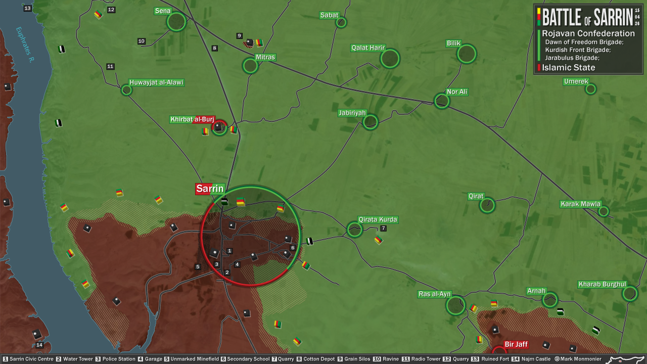
So Sarrin should switch to besieged, but not contested Tgoll774 (talk) 12:04, 27 April 2015 (UTC)
https://pbs.twimg.com/media/CDnp-DoWYAARGJd.jpg Fighting still on outskirts and Khirbat al-Burj still contested. Tgoll774 (talk) 13:20, 28 April 2015 (UTC)
http: //justpaste. it/kvl8 Sarrin is clearly not contested and IS sources state they pushed YPG back and geolocation confirms this is Sarrin. Tgoll774 (talk) 10:39, 2 May 2015 (UTC)
IS claims to have retaken Mitras and Murrabba in this sector https://twitter.com/ActivstMedia999/status/596005854031126528, also a lot of fighting seems to b going on throughout Syria as well with IS hitting Deir Ezzor and Kuwheires as well. Leave it to you guys to corroborate, but it looks like IS Summer Offensive is starting. Tgoll774 (talk) 01:48, 7 May 2015 (UTC)
Sarrin is not contested, repeated photos from the area show YPG is well outside the city having been repulsed. Even YPG sources are saying they been repulsed Tgoll774 (talk) 11:39, 7 May 2015 (UTC)
https://7496bff410df41fc380ad565a50f607d4b1e8372.googledrive.com/host/0BzN49CdHSAwmcGU4eEI5dVBGZXM/KobaniCantonEN-2015-05-10.png Pro-Kurd source confirming a successful IS counterattack in the North. Tgoll774 (talk) 16:10, 10 May 2015 (UTC)
Removing green dot in Kobanê
Why there is still a green dot in Kobanê as well as the nearby villages of Kulmad and Shêran? The FSA left the city and these two villages already in January, when the frontline was shifted to villages far away from the city. Roboskiye (talk) 10:20, 10 May 2015 (UTC)
You don't quite well understand how the map works. I bet 70% of the villages in Kobane area are empty, because obviously YPG needs like 60 000 soldiers to have 24h presence in all of them. We mark villages according to sources who captured them, and how. Of course we also change the situation if a group leaves a town, and another groups captures it. But as we have a joint force situation in Kobane, it's not important to know if a group still has presence in a specific village, because they captured it, and they both move on. Kobane town for example has still rebel presence as FSA Col.Okaidi and (rumours Jamal Marouf) made a HQ in that town. DuckZz (talk) 15:28, 10 May 2015 (UTC)
Okaidi fled the town after a few days visit realizing ISIS is too strong for him to resist. Jamal Marouf presence turned out to be just a rumor. The Sunni/Green presence in Kobanê was not for joint control of the town, rather to use Kobane soil as base for attacks on ISIS who occupies Arab villages around Kobane. Roboskiye (talk) 15:38, 10 May 2015 (UTC)
- DuckZzRoboskiyeThis Kurdish source sometimes showed wher YPG/rebels jointly fight against ISIS.hereherehere So his maps are sometimes very useful. So his maps a sometimes very useful for us. Hanibal911 (talk) 20:44, 10 May 2015 (UTC)
Al Manshara and Debes Checkpoints in Jesr Al Shoughour
Rebel sources claiming shelling of the Manshara CP and taking over Debes CP. This means both checkpoints are SAA held at the moment. [21] [22] ChrissCh94 (talk) 15:20, 10 May 2015 (UTC)
- Reliable source reported that today the clashes continued into the early hours where earlier the rebels retakes some checkpoints from the Syrian troops before being pushed back.Daily Mail Also Syrian TV channel Ikhbariyah reported that today Syrian troops advanced and the tighten their control on the several points and that for now troops a short distance from the city of Jisr al Shughur.Al Ikhbariyah Hanibal911 (talk) 11:41, 11 May 2015 (UTC)
- Also pro opposition source reported that the Regime forces retook Al-Klarin & Sawmill Checkpoint and for now troops stand near sugar factory.here Hanibal911 (talk) 11:44, 11 May 2015 (UTC)
- SOHR also reported that the Syrian troops recaptured two checkpoints near the sugar factory.SOHR Hanibal911 (talk) 11:46, 11 May 2015 (UTC)
- SAA recaptured the barriers(cp's) around Jisr al Shug. road and clashes ongoing around sugar factory and khattab IvanSidorenko1 photo on ground showing circumstance of Sugar Factory. According pro gov PetoLucem SAA took al-Mishrfeh, Tal Qintar and Tal Qartal areas and al laxes leading to Jisr_al_Shughour are now under fire control. Wait for confirmation and localization 217.99.121.133 (talk) 12:28, 11 May 2015 (UTC)
SAA in control of AlMintar and AlKhatab hills near Jisr AlShughour. Photos: here Stharkov (talk) 13:49, 11 May 2015 (UTC)
- These data from the pro government source and we wait confirmation this data from pro opposition or neutral sources. Hanibal911 (talk) 14:53, 11 May 2015 (UTC)