
Talk:Paracel Islands/Archive 2
| This is an archive of past discussions. Do not edit the contents of this page. If you wish to start a new discussion or revive an old one, please do so on the current talk page. |
| Archive 1 | Archive 2 |
Entity locations
Here, I've reverted AGF this series of several edits which changed the locations of a number of entities in the List of entities table. I checked two of the changes: 16°45′N 112°20′E / 16.750°N 112.333°E for Woody Island and 16°25′N 111°40′E / 16.417°N 111.667°E for Duncan Island. The reverted-to location does not match the coords given by the WP article for Woody, but it's close. For both Woody and Duncan, the reverted-to location matches islands shown by Google maps. If there is a problem with this, please discuss here. Wtmitchell (talk) (earlier Boracay Bill) 21:00, 18 July 2014 (UTC)
- Yes, there are some problems. (One example: The precision of some of these co-ordinates greatly exceeds the reality of the situation.) Today I found a reference that seems reliable. I'm about to make whatever Wikipedia says consistent with this reference - whilst this is a work-in-progress, there are likely to be inconsistencies between what-I've-reviewed-so-far and what-I-haven't-reviewed-yet. Cheers, Pdfpdf (talk) 11:27, 19 July 2014 (UTC)
- What is the reference you are using? Relying on it may be a problem if your reference differs significantly with locations shown by other widely-used sources (e.g., Google Maps, Google Earth, Wikimapia. and others shown at the tool page brought up by clicking Coords in a WP article. In the two examples I checked above, the locations you specified did differ significantly. Using links to Google Maps in the following:
- Your location for Woody Island (16°45′N 112°20′E[1]), according to Google Maps and Google Earth, is a point in the South China Sea well south of Woody Island. The reverted-to location (16°50′N 112°19′E[2]) is shown as a point just to the west of Woody Island. The location given in the Woody Island article (16°50′3″N 112°20′15″E[3]) is in the center of Woody Island. A search for "Woody Island" in Google Maps shows a location at 16.8334911N,112.3346379E[4] (equivalent to 16°50′0.568"N 112°20′4.696"E)on Woody Island]
- Your location for Duncan Island (16°25′N 111°40′E[5]) shows a location in the South China Sea southwest of Duncan Island. WP has no article on Duncan Island. A search for "Duncan Island" in Google Maps shows a location at 16.492756N,111.720668E[6] (equivalent to 16°29′33.922"N 111°43′14.405"E) just to the east of Duncan Island.
- Wtmitchell (talk) (earlier Boracay Bill) 23:39, 19 July 2014 (UTC)
- What is the reference you are using? Relying on it may be a problem if your reference differs significantly with locations shown by other widely-used sources (e.g., Google Maps, Google Earth, Wikimapia. and others shown at the tool page brought up by clicking Coords in a WP article. In the two examples I checked above, the locations you specified did differ significantly. Using links to Google Maps in the following:
- I'm a bit confused by your response; the timestamp suggests you made it after my most recent changes, but the answers to all your questions are in Paracel Islands.
- What is the reference you are using? - "Sector 1: The South China Sea - Central Part" (PDF). Sailing Directions - Publication 161 - 14th Edition. National Geospatial-Intelligence Agency, U.S. Government. 12 July 2014. Retrieved 19 July 2014.
Subsequent Publication Data Updates (PDUs) have corrected this publication to 12 July 2014
- Relying on it may be a problem if your reference differs significantly with locations shown by other widely-used sources (e.g., Google Maps, Google Earth, Wikimapia. and others - True. More on that embedded in the following.
- Woody Island
- Your location for Woody Island (16°45′N 112°20′E) was wrong and has been corrected to 16°50′N 112°20′E to match the reference.
- The reverted-to location (16°50′N 112°19′E) is very similar, but not identical.
- The location given in the Woody Island article (16°50′3″N 112°20′15″E) is again similar, but not identical.
- A search for "Woody Island" in Google Maps shows a location at 16.8334911N,112.3346379E (equivalent to 16°50′0.568"N 112°20′4.696"E) which again is similar, but not identical.
- Duncan Island
- Your location for Duncan Island (16°25′N 111°40′E) was wrong and has been corrected to 16°27′N 111°44′E to match the reference.
- ... Google Maps ... (equivalent to 16°29′33.922"N 111°43′14.405"E) - Hmmm. Not quite so similar. I see the reference only gives "Duncan Islands" (plural) - i.e. it doesn't distinguish Duncan Island (singular) from Palm Is. - perhaps my extrapolation is not good enough.
- What is the reference you are using? - "Sector 1: The South China Sea - Central Part" (PDF). Sailing Directions - Publication 161 - 14th Edition. National Geospatial-Intelligence Agency, U.S. Government. 12 July 2014. Retrieved 19 July 2014.
- In any case, it would appear to me that the NGA's Sailing Directions and "Google Maps, Google Earth, Wikimapia and others" pretty much agree with each other - you would rather hope that the would, wouldn't you!! ;-)
- (Which is handy, because now we have a reliable source, whereas previously we were subject to the whims of wikipedants who might irritatingly have argued that using numbers from the other sources amounted to WP:OR.
- Cheers, Pdfpdf (talk) 06:02, 20 July 2014 (UTC)
- I'm a bit confused by your response; the timestamp suggests you made it after my most recent changes, but the answers to all your questions are in Paracel Islands.
- I shamefacedly acknowledge your corrections above, and I thank you for those corrections. It looks like I somehow made transcription errors above and relied on my wrongly transcribed coordinates without rechecking them when I saw problems. I see that the corrected coordinates for Woody Island above match well with its location when clicked and followed to Wikimapia[7] and Google maps[8]. I haven't checked the other features but I'll presume that they match more or less this well -- well enough to unambiguously identify the feature if the coordinates are clicked on and followed to a map. Also, I agree with your point about reliable and verifiable sourcing and that this source is both reliable and verifiable.
- How good is good enough to be unambiguous? The short answer is to follow the links and look at one or more maps. However, one minute is close to one nautical mile (less for E/W positions at locations not on the equator). One second is roughly 100 feet and a hundredth of a minute is roughly half a second. Specifying coordinates as DMS with no decimals or as degrees and decimal minutes to two decimal places ought to be plenty good enough to unambiguously locate an island. A thousandth of a degree is more than 350 feet, but specifying coordinates as decimal degrees to three decimal places ought to be good enough for all but very small islands. Wtmitchell (talk) (earlier Boracay Bill) 03:51, 22 July 2014 (UTC)
- Apologies to all for the confusion. Wtmitchell (talk) (earlier Boracay Bill) 03:51, 22 July 2014 (UTC)
- No! Not at all!! It was me who made the original injudicious changes, and I am indebted to you for pointing this out and causing me to find a reliable source (which, by-the-way, did not support my original changes!!) I'm relieved we have reached a mutually acceptable end-point, and I apologise for inconveniencing you. (Mea culpa). Cheers, Pdfpdf (talk) 16:19, 22 July 2014 (UTC)
Map of Paracel Islands
I have found a map of Paracel Islands from this webpage, which I think is a good figure to use in the article as it supports 3 languages. However I am not familiar with the copyright instructions so I did not upload it to avoid another deletion. Could someone help determine whether it could be uploaded and upload it if so? Thank you. Huydp (talk) 12:41, 18 August 2014 (UTC)
Check name and image caption
In the Xisha section, it says that its name in the Ming dynasty was 万里石塘 (Wanli Shitang), but I think that refers to Spratly Islands (See Spratly Islands#Early cartography). In the Mao Kun map shown, it says on the bottom (from left to right) 石塘, 萬生石塘嶼, and 石星石塘, which could be Paracel, Spratly and Dongsha (or perhaps Zhongsha) respectively. I changed the wording of the caption because it looks wrong to me, given that Paracel can't be the easternmost one. But I don't know much about this, so can someone check that what's written is correct? Hzh (talk) 23:03, 18 July 2015 (UTC)
External links modified
Hello fellow Wikipedians,
I have just added archive links to 6 external links on Paracel Islands. Please take a moment to review my edit. If necessary, add {{cbignore}} after the link to keep me from modifying it. Alternatively, you can add {{nobots|deny=InternetArchiveBot}} to keep me off the page altogether. I made the following changes:
- Added archive https://web.archive.org/20130313233455/http://www.vietnam.vn/the-hoang-sa-paracel-and-truong-sa-spratly-archipelagoes-and-international-law-1988-c1070n20120102121508750.htm to http://www.vietnam.vn/the-hoang-sa-paracel-and-truong-sa-spratly-archipelagoes-and-international-law-1988-c1070n20120102121508750.htm
- Added archive https://web.archive.org/20140517153130/http://www.atimes.com/china/AG15Ad01.html to http://www.atimes.com/china/AG15Ad01.html
- Added archive https://web.archive.org/20130722004321/http://www.atimes.com/atimes/China/LG29Ad01.html to http://www.atimes.com/atimes/China/LG29Ad01.html
- Added archive https://web.archive.org/20131207194127/http://atimes.com/atimes/China/NH10Ad01.html to http://www.atimes.com/atimes/China/NH10Ad01.html
- Added archive https://web.archive.org/20150816025728/http://www.atimes.com/atimes/China/NF13Ad01.html to http://www.atimes.com/atimes/China/NF13Ad01.html
- Added archive https://web.archive.org/20150113122749/http://www.atimes.com/atimes/China/CHINA-01-140213.html to http://www.atimes.com/atimes/China/CHINA-01-140213.html
When you have finished reviewing my changes, please set the checked parameter below to true to let others know.
This message was posted before February 2018. After February 2018, "External links modified" talk page sections are no longer generated or monitored by InternetArchiveBot. No special action is required regarding these talk page notices, other than regular verification using the archive tool instructions below. Editors have permission to delete these "External links modified" talk page sections if they want to de-clutter talk pages, but see the RfC before doing mass systematic removals. This message is updated dynamically through the template {{source check}} (last update: 18 January 2022).
- If you have discovered URLs which were erroneously considered dead by the bot, you can report them with this tool.
- If you found an error with any archives or the URLs themselves, you can fix them with this tool.
Cheers. —cyberbot IITalk to my owner:Online 09:47, 27 August 2015 (UTC)
External links modified
Hello fellow Wikipedians,
I have just added archive links to one external link on Paracel Islands. Please take a moment to review my edit. If necessary, add {{cbignore}} after the link to keep me from modifying it. Alternatively, you can add {{nobots|deny=InternetArchiveBot}} to keep me off the page altogether. I made the following changes:
- Added archive https://web.archive.org/web/20120626045014/http://www.smh.com.au/world/china-gets-tough-as-vietnam-claims-disputed-islands-20120622-20th6.html to http://www.smh.com.au/world/china-gets-tough-as-vietnam-claims-disputed-islands-20120622-20th6.html
When you have finished reviewing my changes, please set the checked parameter below to true or failed to let others know (documentation at {{Sourcecheck}}).
This message was posted before February 2018. After February 2018, "External links modified" talk page sections are no longer generated or monitored by InternetArchiveBot. No special action is required regarding these talk page notices, other than regular verification using the archive tool instructions below. Editors have permission to delete these "External links modified" talk page sections if they want to de-clutter talk pages, but see the RfC before doing mass systematic removals. This message is updated dynamically through the template {{source check}} (last update: 18 January 2022).
- If you have discovered URLs which were erroneously considered dead by the bot, you can report them with this tool.
- If you found an error with any archives or the URLs themselves, you can fix them with this tool.
Cheers.—cyberbot IITalk to my owner:Online 15:09, 22 March 2016 (UTC)
Copyvio concern
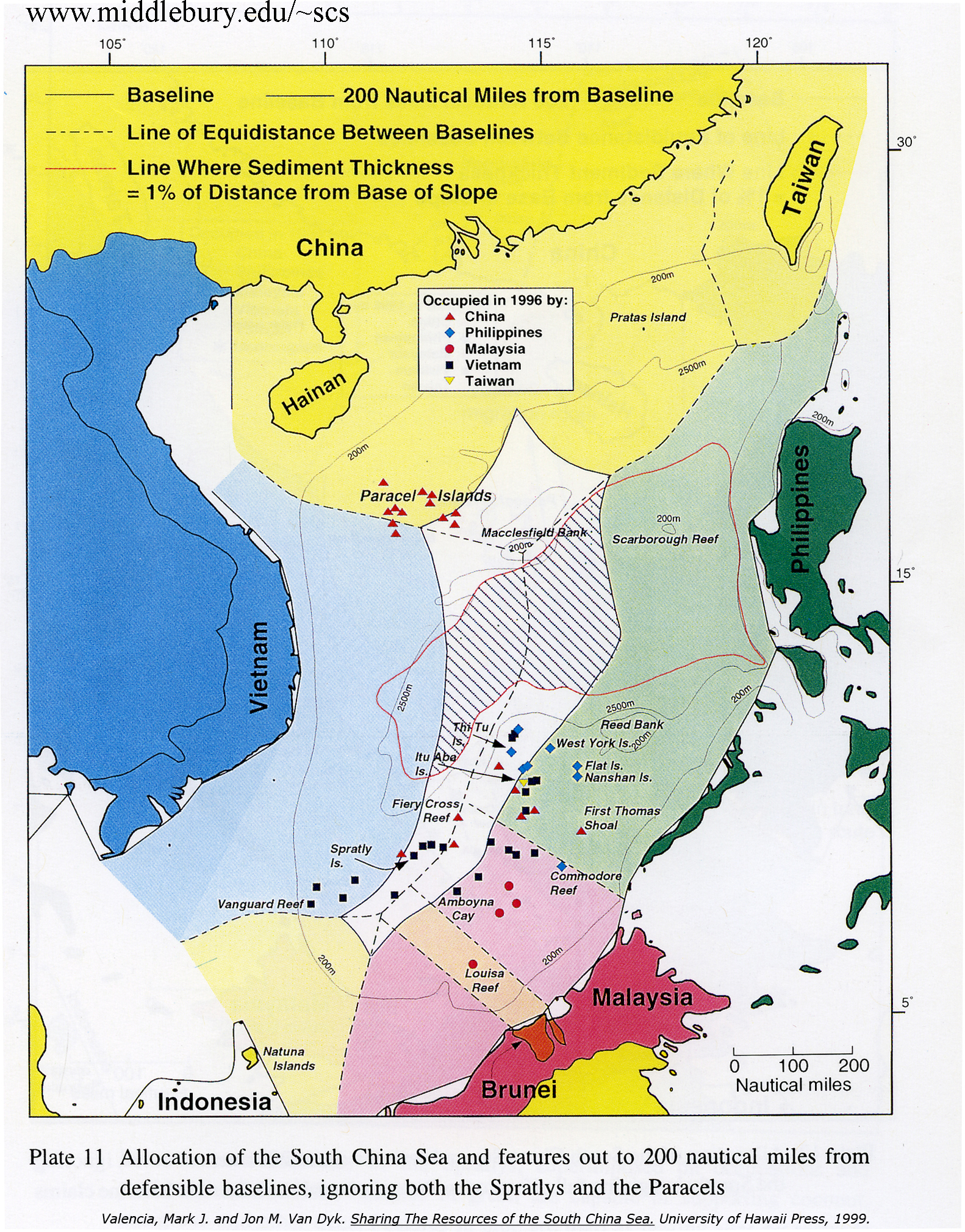
I just made this edit, reverting what appears to be a WP:OR, POV edit of the UNCLOS EEZ section of the article by an anonymous editor. In the process of doing this, I looked at this linked external image of a map which is cited as a supporting source for the assertion which I reverted. I noticed that the image appears to be a copy of Valencia, Mark J.; Dyke, Jon M. Van; Ludwig, Noel A. (1997). Sharing the Resources of the South China Sea. University of Hawaii Press. p. 260. ISBN 978-0-8248-1881-4. The copyright page of that book can be seen here. This raised WP:COPYVIO concerns in my mind (quoting: "Copyright infringing material should also not be linked to"). I'm not a WP:Copyright maven, so I have not taken any action beyond raising the concern here. Wtmitchell (talk) (earlier Boracay Bill) 22:28, 5 August 2016 (UTC)
UNCLOS EEZ section
The UNCLOS EEZ section contained the following:
China claimed that most of the Paracel Islands are within China's 200 nautical-mile EEZ as defined by UNCLOS. However it is not true according to the UNCLOS.
Citing http://www.southchinasea.org/files/2011/08/eez3_full.jpg in support. The cited supporting source is a map on the southchinasea.org website which is atributed to "www.middlebury.edu/~scs" which, as a URL, redirects to the southchinasea.org home page. The map is further attributed in small print at the bottom to the book Mark J. Valencia; Jon M. Van Dyke; Noel A. Ludwig (1997). Sharing the Resources of the South China Sea. University of Hawaii Press. ISBN 978-0-8248-1881-4. The map appears on page 263 of that book, and its presentation on the southchinasea.org website appears to be a copyright violation.
- The cited source does not support the assertion that China claimed that most of the Paracel Islands are within China's 200 nautical-mile EEZ as defined by UNCLOS.
- The cited source does not support any assertion about what is or is not true according to UNCLOS.
- The cited source shows a "200 NM from baseline" line and shows 12 Paracel islands as claimed by China, 7 of which are shown as being within that line, 3 of which are shown on that line, and 2 of which are shown outside that line.
I have rewritten the section to say:
The Paracel islands are claimed by China and the majority of those islands lie within 200 NM from China's geographic baseline.
Citing the map in the book in support. Wtmitchell (talk) (earlier Boracay Bill) 04:12, 13 September 2016 (UTC)
External links modified
Hello fellow Wikipedians,
I have just modified 8 external links on Paracel Islands. Please take a moment to review my edit. If you have any questions, or need the bot to ignore the links, or the page altogether, please visit this simple FaQ for additional information. I made the following changes:
- Added archive https://web.archive.org/web/20140917094345/http://www.visithainan.com.au/feature-report/314-paracel-islands-the-new-great-barrier-reef.html to http://www.visithainan.com.au/feature-report/314-paracel-islands-the-new-great-barrier-reef.html
- Corrected formatting/usage for http://epub.cnki.net/grid2008/detail.aspx?filename=WENW197410000&dbname=CJFQ1979
- Corrected formatting/usage for http://epub.cnki.net/grid2008/detail.aspx?filename=LYWT199004009&dbname=CJFQ1990
- Corrected formatting/usage for http://www.atimes.com/china/AG15Ad01.html
- Corrected formatting/usage for http://www.atimes.com/atimes/China/NH10Ad01.html
- Corrected formatting/usage for http://www.atimes.com/atimes/China/NF13Ad01.html
- Corrected formatting/usage for http://www.atimes.com/atimes/China/CHINA-01-140213.html
- Added archive https://web.archive.org/web/20140517152216/http://www.wantchinatimes.com/news-subclass-cnt.aspx?cid=1701&MainCatID=17&id=20140513000104 to http://www.wantchinatimes.com/news-subclass-cnt.aspx?cid=1701&MainCatID=17&id=20140513000104
When you have finished reviewing my changes, you may follow the instructions on the template below to fix any issues with the URLs.
This message was posted before February 2018. After February 2018, "External links modified" talk page sections are no longer generated or monitored by InternetArchiveBot. No special action is required regarding these talk page notices, other than regular verification using the archive tool instructions below. Editors have permission to delete these "External links modified" talk page sections if they want to de-clutter talk pages, but see the RfC before doing mass systematic removals. This message is updated dynamically through the template {{source check}} (last update: 18 January 2022).
- If you have discovered URLs which were erroneously considered dead by the bot, you can report them with this tool.
- If you found an error with any archives or the URLs themselves, you can fix them with this tool.
Cheers.—InternetArchiveBot (Report bug) 16:02, 26 July 2017 (UTC)
"Paracel Islands/Economy" listed at Redirects for discussion

An editor has asked for a discussion to address the redirect Paracel Islands/Economy. Please participate in the redirect discussion if you wish to do so. 1234qwer1234qwer4 (talk) 17:34, 12 April 2020 (UTC)
"Paracel Islands/Military" listed at Redirects for discussion
An editor has asked for a discussion to address the redirect Paracel Islands/Military. Please participate in the redirect discussion if you wish to do so. 1234qwer1234qwer4 (talk) 17:49, 12 April 2020 (UTC)
"Paracel Islands/Transnational issues" listed at Redirects for discussion
An editor has asked for a discussion to address the redirect Paracel Islands/Transnational issues. Please participate in the redirect discussion if you wish to do so. 1234qwer1234qwer4 (talk) 17:52, 12 April 2020 (UTC)
Semi-protected edit request on 21 April 2020
Description of "Administed by People Republic of China" is absolutely wrong as the islands are disputed area between many countries. Wikipedia must be neutral
- Wikipedia IS neutral, "Administed by" doesn't mean "sovereignty by". minhhuy (talk) 09:38, 21 April 2020 (UTC)
Please split Xisha District from this article
As China officially set this district under Chinese name "西沙区", cf. [9] and [10]. --Liuxinyu970226 (talk) 01:16, 2 May 2020 (UTC)
- Seems
 Done by ASDFGH. --Liuxinyu970226 (talk) 00:30, 12 August 2020 (UTC)
Vietnam control it
I know that because I'm a Vietnamese people , we control all these islands,why you said that China control and administer it ???? I hate Chinaaaaaaaa
- See WP:RS re acceptable suppo9rting soures. Wtmitchell (talk) (earlier Boracay Bill) 14:34, 11 November 2020 (UTC)
Wrong date / Vietnam prioritization
The "5th–17th centuries" subheader in the "Historical perspectives" section has a typo. It's supposed to be the 15th century, not 5th. On a related note, it seems weird for Vietnam's historical perspective to be prioritized by being listed first as China both controls the Islands and has an earlier historic claim. — Preceding unsigned comment added by PurpleYola (talk • contribs) 07:48, 17 January 2021 (UTC)
Missing Geology Section
Are the islands volcanic, carbonate platforms, andesite, or what? Cadwallader (talk) 01:24, 9 November 2021 (UTC)
Non-english addition
Here, I have reverted as unhelpful, but assuming good faith, the addition of a footnote which would have appeared as follows: 大南寔錄前編·顯宗孝明皇帝寔錄下》:廣義平山縣安永社海外有沙州一百三十餘,所相去或一日程,或數更許,延袤不知其幾千里,俗稱萬里黃沙;洲上有井甘泉出焉,所產有海參、玳瑁、文螺、黿鼇等物。國初置黃沙隊七十人,以安永社民充之,歲以三月乘船往三日,夜抵其處採取貨物,以八月回納;又有北海隊,募平順四政村或景陽社人充之,令駕小船往北海崑崙等處採取貨物,亦由黃沙隊併管。
I don't think this addition in that form would improve the article. According to Google Translate, this could be rendered in English as follows: "The First Edition of the Great Southern Records: Emperor Xianzong's Xiaoming Emperor's Records": There are more than 130 Shazhou overseas in the Ernong Society of Pingshan County, Guangxi, and they may go on a schedule, or more, and they extend for thousands of miles, Commonly known as Wanli Huangsha; there are wells and springs on the continent, which produce sea cucumbers, tortoiseshells, snails, scorpions and other things. At the beginning of the country, there were 70 people in the Huangsha team, and they were filled with the people of the Ernst and Young Society. They traveled by boat for three days in March, arrived there at night to collect goods, and returned to pay in August; The people of the Yang Society filled it up and ordered a small boat to go to Kunlun in the North Sea to pick up the goods, which was also managed by the Huangsha team.
That does mention a supporting source. Perhaps it contains what could be a useful addition to the article and information sufficient to identify a supporting cite. I'm not clear oh where I might searching in order to properly cite the source mentioned there. Wtmitchell (talk) (earlier Boracay Bill) 15:39, 3 March 2022 (UTC)
Insertion re 17th parallel
I have moved the following insertion made by @QUOBSERVER: in this edit here for discussion
secretary general at this epoch was Dag Hammarskjold(1905 - 1961). The viêtnamese participants were represented by both Viet Minh and the nationalists represented in person by Her Majesty Chief of State Bảo Đại(1913 - 1997). The Geneva Agreements were signed on July 20,1954 recognizing the 17th latitude as the demarcation line between the two Viêt nam, rejecting the communists' proposal to take the 13rd latitude which theorically included the Paracel Islands, subsequently, agred this archipelago as integral part of the south viêtnamese teritorial sovereignty! What Bảo Đại claimed in his decree signed on March 30,1938. During the development of the Conference, the Bảo Đại's representative was his prime minister Bửu Lộc from January 11th,1954 to June 16th,1954, replaced by Ngo Dinh Diem since July 07,1954, sustained by cardinal bishop Francis Spellman(1889 - 1967),after the
Geneva Conference's concensus to vote for the 17th latitude as demarcation line on June 23rd,1954. The replacement of an aristocrate by a catholic believer prepared to a predictable northern refugees' campaign (up to 1,500,000).This was removed from a point immediately following an assertion reading: "The Paracel archipelago lies south of this line and belongs to South Vietnam accordingly" I have not removed that assertion, but I did tag it {{cn span}} in a previous edit..
This contains a number of spelling and grammatical problems, and also contains unsupported assertions re an agreement re the Paracels reached subsequent to the 1954 Geneva accords.
I'm not sure offhand whether or not the assertions in the boxed text above are supportable. If they are, they need to be supported. I thought it best to remove this from the article until this was resolved. Perhaps there's an easy resolution, or perhaps discussion towards an editorial consensus is needed, Please discuss here rather than WP:edit warring about it in the article. Wtmitchell (talk) (earlier Boracay Bill) 09:14, 20 June 2022 (UTC)
"Champa Kingdom" section
Why is this section allowed to remain as it is? Nearly the entire text of it is completely irrelevant to the topic of the page. It rambles and discusses the Champa Kingdom itself rather its bearing upon or relationship to the Paracel Islands. Precisely one sentence appears relevant to the topic.
This section should be removed or heavily edited. Macraig (talk) 10:05, 3 August 2022 (UTC)
One cite
The cite reading Monique Chemillier-Gendreau, Sovereignty Over the Paracel and Spratly Islands, p36 Archived January 1, 2016, at the Wayback Machine, p37 , p68 , p69 , p71 , p72 , p74 , p129 Archived July 14, 2014, at the Wayback Machine, Kluwer Law International, ISBN 90-411-1381-9. Retrieved August 4, 2009 caught my eye. I tried to follow some of the links there, and found them dead.
Looking back, I see that this work was first mentioned by an anon in this revision as an External links item. I was surprised to find the work -- perhaps a different edition -- partially previewable as Chemillier-Gendreau, M. (2021). Sovereignty over the Paracel and Spratly Islands. Brill. ISBN 978-90-04-47942-5. Looking at page 37 (mentioned in the cite current in the article), I didn't see anything clearly relevant to the content it is cited to support (as far as I could see, anyhow). FWIW, I see that the p37 was added here by @Trinhbaongoc:, but not in its current form.
This looks like it needs a look by an editor with more topical knowledgeable than I have. Wtmitchell (talk) (earlier Boracay Bill) 03:23, 28 August 2022 (UTC)
the distance from Vietnam to paracels?
I think that it is nearer vietnam than China but the website www.paracels.info [11] said: The Paracel Islands (known in Vietnam as the Hoang Sa or Quan Dao Hoang Sa,known in China as the Xisha Islands, or Xisha Dao [ 西沙岛], or Xisha Qundao [ 西沙群島 ] ) about 250 miles off the coast of Hainan. They are also about the same distance off the coast of Vietnam. In 1932, French Indochina annexed the islands and set up a weather station on Pattle Island; maintenance was continued by its successor,Vietnam.The islands were formerly part of Vietnam, and were controlled by Vietnam until 1974 when China forcibly took them from Vietnam Some thing is wrong? — Preceding unsigned comment added by 117.7.2.200 (talk • contribs) 14:13, 28 June 2008 (UTC)
Clarification of polities in the lede.
The original lede obscures the fact that there are two Chinese and two Vietnamese polities involved in the history of the islands.
- The Paracel Islands . . . is a group of islands . . . whose sovereignty is disputed by the People's Republic of China, the Republic of China (Taiwan) and Vietnam. All of the islands are currently controlled as part of China's Hainan Province, which in July 2012, established Sansha City to administer the three townships under its jurisdiction. Chinese and Vietnamese forces both occupied parts of the Paracel Islands before 1974, when the Battle of the Paracel Islands occurred, after which the former took control of the entire group.
The first sentence mentions the two Chinas but the second sentence refers to China, without specifying which one. The last sentence gives the impression that China and Vietnam fought a war over the islands and that Vietnam controlled the islands prior to 1974. In reality though, it was the PRC that took the islands from South Vietnam in 1974. The North Vietnamese government has never controlled the islands but has inherited the Vietnamese claim. My edits clarify those two points. The usage of official names of the two Vietnamese regimes follows the parallel construction of the two Chinese regime names.
- The Paracel Islands . . . is a group of islands . . . whose sovereignty is disputed by the People's Republic of China, the Republic of China (Taiwan) and Vietnam. All of the islands are currently controlled by People's Republic of China, which captured the islands from the Republic of Vietnam (South Vietnam) in January 1974. The Socialist Republic of Vietnam, which unified Vietnam in 1976, has continued to claim the islands. The People's Republic of China established the city of Sansha, under Hainan Province in July 2012, to administer the islands.
— Preceding unsigned comment added by ContinentalAve (talk • contribs) 00:46, 14 May 2014 (UTC)