
Talk:Treaty of Sèvres/Archive 1
| This is an archive of past discussions about Treaty of Sèvres. Do not edit the contents of this page. If you wish to start a new discussion or revive an old one, please do so on the current talk page. |
| Archive 1 |
Assyria
Could anybody tell me where in the Treaty an independent Assyria is mentioned? Can't remember ever reading that, but may be I missed it. Nightworker 23:18, 22 January 2006 (UTC)
- There is no mention of an independent Assyria, the Assyro-Chaldeans were only protected minorities within the new boundaries
- That's exactly as I remembered. Thanks - who ever you are.Nightworker 23:02, 25 January 2006 (UTC)
Soviet Participation
The effect of Soviets looks like a key element in the indipendence war when we read this article but this is not true. Yes Soviets gave us military equipment(Max. 1/5 of the nationalist army used their ammo) but that is all. Mustafa Kemal Pasha used every help to defeat the invaders. With respect, Deliogul 19:22, 10 August 2006 (UTC)
Not clear
This article contains two maps of what is apparently the same thing, "The proposed Armenian state". However, sorry to say that neither of them is clear. One is virtually monochrome and almost entirely illegible. The other has lots of shaded bits but no legend (at least not in English) and captions only in a foreign language (Armenian perhaps?). Reading the article doesn't help. I'm left with no idea what the scope of the proposed state was. -JdSf 16:35, 25 November 2006 (UTC)
Missing Headline
There is a section in the main article which lacks any definition or title. Can it's author edit and present it in a more appropriate manner. It is the section which contains 2 articles from the treaty. Thalion Hurin 10:54, 12 February 2007 (UTC)
Kurdistan
This page only mentions that Kurdistan was to be an autonomus part of turkey. When in fact they (the kurds) would be granted independence from turkey if they wished acording to Section III Article 64: "If within one year from the coming into force of the present Treaty the Kurdish peoples within the areas defined in Article 62 shall address themselves to the Council of the League of Nations in such a manner as to show that a majority of the population of these areas desires independence from Turkey, and if the Council then considers that these peoples are capable of such independence and recommends that it should be granted to them, Turkey hereby agrees to execute such a recommendation, and to renounce all rights and title over these areas."
There is no mention of this! There is also no mention of that the kurdish part called the Mosul Vilayet in the traty, could if they wished join the independent Kurdistan.
- I believe there are areas within Wiki that suggests the Kurds are allowed to have an Independent Kurdistan, however, the treaty was never signed by the Ottoman Sultan. —The preceding unsigned comment was added by 143.81.252.12 (talk • contribs) 22:33, 25 November 2006.
I agree. Why not revise the text? Nightworker 23:03, 25 January 2006 (UTC)
- Write "Turk" by using the capital letter. Deliogul 19:05, 16 February 2007 (UTC)
Material regarding Sèvres should be merged here. There is more than enough room for the material here. -- Cat chi? 01:25, 7 May 2007 (UTC)
- O.K. --OttomanReference 02:41, 7 May 2007 (UTC)
- OK. Correct place.Must.T C 05:10, 7 May 2007 (UTC)
- Sure the material there can be copied here. I am not sure about deleting the section afterwards though, if that's what's meant by this merger. DenizTC 16:56, 7 May 2007 (UTC)
What are you merging exactly? again as collective Turkish group doing "Karanlik isler". Özgūr Talk Hist 18:41, 7 May 2007 (UTC)
- Please stick to English language on English wikipedia. The proposed merge is moving all/most content regarding serves from that article to here. -- Cat chi? 18:43, 7 May 2007 (UTC)
Map caption
I changed one of the map captions: it was described as a "modern Cambridge University" map, but it certainly isn't modern, and Cambridge University Press (the publisher) is not exactly the same thing as the university. I guess this map may be taken from the Cambridge Modern History of the early 20th century. Andrew Dalby 15:23, 8 July 2007 (UTC)
Replaced?
I added a fact tag to the "replaced the Treaty of Sevres" and renamed the supposed "Nullification" section to something more approriate. - Fedayee (talk) 00:18, 27 November 2007 (UTC)
Surely this phrase is opinion or at least should be backed up by references
I found the following sentence to little more than pure opinion - surely it should be backed up by references or removed - what do others think?
"This had been the dream of Christianity for nearly five hundred years beginning with Holy Leagues, the Ottoman Empire put into a condition that can never be revived again in its old form." —Preceding unsigned comment added by Nznewsguy (talk • contribs) 08:42, 28 December 2007 (UTC)
I agree: this is historically nonsensical Gugawn (talk) 19:54, 7 March 2008 (UTC)
Conflicting Statements
This says the Ottoman Empire didn't sign the treaty, yet 'had four signatories on behalf of the Ottoman government'.
So, the meaning is really that it was signed and not ratified, right?
NantucketNoon 15:22, 23 October 2007 (UTC)
Signing a treaty and then having it ratified by the legal body nominally authorized to approve it, in general a congress or assembly or a parliament are two different things. —Preceding unsigned comment added by 173.77.156.90 (talk) 15:52, 21 June 2009 (UTC)
Most populous
To claim that Turks were the most populous is speculation. The two groups who were mostly concentrated in Eastern Anatolia were Kurds and Armenians. There was a considerable population of Circassians, Kurds, Turkmans, Zaza's etc. Assuming that Turks outnumbered Armenians in Eastern Anatolia is original research when the most populous Muslim population there were Kurds not Turks. The Turks were concentrated more Westward, Erzerum was rather the exception than the rule. VartanM 03:24, 17 August 2007 (UTC)
- Flavious, can you please provide sources that confirm your claim. VartanM 02:20, 26 August 2007 (UTC)
- Please make your decision. If Turks exterminated Armenians back in 1915, it is impossible to claim that Armenians were one of the two most populous groups in the region. Even if we don't take the genocide thing into consideration, it is so clear that the Treaty of Serves was giving huge lands to Armenians that contains places where Armenians were not even close to be the "most populous". Also, there are people who claim that there were no 1,5 million Armenians in the region back in 1915 to be exterminated and these numbers are created to support the modern day strategy of Armenia to claim rights on Anatolia. Look, I didn't talk about Turks or Kurds. People just have to see that there are also problems in the stories of the other parties of the debate. Deliogul 07:39, 27 August 2007 (UTC)
Deliogul, were talking about timeperiod before the Armenian Genocide. Modern day Armenia has no claims on Anatolia. can you provide sources that confirm what you just said? Here is my version:
- Armenia: was given a large part of the region; including provinces which didn't have significant Armenian populations remaining after the massacres and deportations, such as the Black Sea port city of Trabzon.
Here is his version:
- Armenia: The Armenians, who had constituted the third largest ethnic group in Eastern Anatolia after the Turks and Kurds even before the Armenian Genocide, were given a large part of the region; including provinces which didn't have significant Armenian populations such as the Black Sea port city of Trabzon.
My version doesn't even mention the "genocide thing". It's clear to me that I'm not going to get any feedback from Flavious. Deliogul, feel free to provide the source claiming that Armenians constituted the third largest ething group in Easter Anatolia after the Turks and Kurds. --VartanM 08:42, 27 August 2007 (UTC)
- So you say modern day Armenia has nothing to do with the Greater Armenia. That doesn't sound rational to me. Also, your version can falsely make people think that Trabzon once was dominated by Armenians. That would be impossible, at least, for the last millennium (see Empire of Trebizond, reign of Mehmed II). By the way, I will have a look at the library of my college to solve this debate. See you, Deliogul 13:37, 27 August 2007 (UTC)
- Let's not forget, that an Empire is a state, that rules other nations and territories of countries. Who are majority or minority has little to do with the territory of the states ruled by an empire.
- however, the numbers cannot be objectively viewed if they are presented by a biased party. Here it is the Empire, as it clearly had an interest of lowering the, let me call them, "undesired-nations'" population in the empire at least on documents. As a result the population numbers on documents could have an effect on parliamentary elections, local governors' choice etc.
- VartanM didn't say that the modern-day Armenia has nothing to do with the Kingdom of Greater Armenia. He said that the Republic of Armenia has not presented territorial claims to the Republic of Turkey.
- I see the discussion wasn't finished after all... Aregakn (talk) 12:32, 26 April 2010 (UTC)
The map

I do not know who removed this map, but this is better than a drawing. --TarikAkin (talk) 04:25, 15 April 2008 (UTC)
The map is an unclear map with wrong borders. Aregakn (talk) 12:35, 26 April 2010 (UTC)
Italy
It says "portions of southern Anatolia, were to pass to Italy". Does anyone know where to find more information about this? A map including what the Italians would have gained would be great--Stavros15 12:51, 22 March 2007 (UTC)
- Parts of the Turkish Aegean and present day Antalya were promised to Italy with couple of agreements during WWI but then Italy had problems with the Allies and withdrew from her promised territories which paved the way for Greece to show up and claim the Western Anatolia. See you, Deliogul 14:27, 22 March 2007 (UTC)
- I also have to add that the British government of the time had a big effect on this political change. Deliogul 21:33, 1 June 2007 (UTC)
ATTENTION. THERE IS A MAJOR MISTAKE CONCERNING ITALY AND THE DODECANESE ISLANDS ARTICLE 122. Turkey renounces in favour of Italy all rights and title over the following islands of the Aegean Sea; Stampalia (Astropalia), Rhodes (Rhodos), Calki (Kharki), Scarpanto, Casos (Casso) Pscopis (Tilos), Misiros (Nisyros), Calymnos (Kalymnos) Leros, Patmos, Lipsos (Lipso), Sini (Symi), and Cos (Kos), which are now occupied by Italy, and the islets dependent thereon, and also over the island of Castellorizzo. —Preceding unsigned comment added by 94.67.140.167 (talk) 10:31, 24 May 2010 (UTC)
Place names
Some placenames are obscure, e.g. "country of Mount Arisarieh", for which Google only returns this treaty. What is it called today? All place names should be linked to the proper Wikipedia article, and those articles should mention the historic names. --LA2 (talk) 04:23, 23 February 2012 (UTC)
Meaning?
'...possibly as a sop to Armenian claims to that region).'
I am supposing this means 'slap'. —Preceding unsigned comment added by NantucketNoon (talk • contribs) 15:15, 23 October 2007 (UTC)
- No it doesn't. It means something like 'small concession' or 'thing to make them feel better'. I know that this is an old commment, but I am just responding in case anyone else has the same question.130.216.234.135 (talk) 04:45, 27 May 2013 (UTC)
Misleading article
So is there not going to be a single mention of the fact that throughout most of the Turkish rule the region was predominantly Turkish or are these articles just written to justify an unjust, illegal treaty. Why is'nt there a single mention of the fact that the Ottoman government was put there by the Allied invaders and did not in any way, shape or form represent the will of the Turkish people? — Preceding unsigned comment added by 88.242.206.116 (talk) 15:00, 11 September 2013 (UTC)
- see Sèvres Syndrome --Երևանցի talk 15:04, 11 September 2013 (UTC) — Preceding unsigned comment added by HouseOfArtaxiad (talk • contribs)
- because nobody other than the ultranationalist user Yerevanci responded, İm going to suggest that the demographics of the region should be included.
- DO it yourself.88.242.208.71 (talk) 09:30, 17 September 2013 (UTC)
- see WP:CIVIL and try to avoid using terms such as "ultranationalist". That does not prove your point. Most of Eastern Turkey was populated by Armenians before the Armenian Genocide. If that makes me a nationalist, then yes, I am a nationalist. If you are so interested in historical ethnography, then you should probably add somewhere in Turkey that large areas of its territory was inhabited by Greeks and Armenians until early 20th century. You and me or any other user is not a judge here to claim that the Sevres Treaty was "unjust, illegal treaty." --Երևանցի talk 17:01, 18 September 2013 (UTC)
- Seeing as how Greeks were the dominant population of Smyrna and the Eastern area was depopulated and formally populated by Armenians, no, I would not say mentioning that is notable, because it's a lie. And do not delete other people's comments. If you continue your vandalism, you will be blocked. HouseOfArtaxiad (talk) 16:44, 18 September 2013 (UTC)
- Eastern Turkey was populated mostly bu Turks. This is proven by every census and estimate except the Armenian Patriarchs and the notoriosly manipulative Arnold Toynbee estimates. İt is also unlikely that Armenians were a majority or even a notable minority in tebizond. Both of your claims are baseless. — Preceding unsigned comment added by 88.242.168.61 (talk) 12:09, 19 September 2013 (UTC)
- It is proven that Armenians were majority both in Van and Mush, also in Zeitun, Hachn, Marash and many more areas. Also, I suggest you stop relying on Ottoman census, because most historians say they were inaccurate and manipulated for political purposes. --Երևանցի talk 15:13, 19 September 2013 (UTC)
- Proven. thats an awfully audacious claim. Proven by whom exactly. Contemporary sources put Armenians as a minority in eastern Turkey. it is also highly unlikely Armenians were a majority in Marash. I suggest you read the demographics of the Ottoman empire page before you make any claims on demographics80.43.13.95 (talk) 12:02, 21 September 2013 (UTC)
Ambassador in Picture
I believe the "unknown" figure in the picture is Paul Cambon, brother of Jules Cambon. Ealtram (talk) 15:06, 20 June 2015 (UTC)
Wilsonian Armenia
Removed the part where it said Trabzon weren't inhabited by Armenians. According the Trabzon page, it was inhabited by Armenian, plus Armenians have been living in that region for centuries even before the Ottoman period. Adorkable Corgi (talk) 10:25, 9 July 2015 (UTC)
Ratification
Correct me if I'm wrong, but wasn't this treaty signed and ratified by Damat Ferid Pasha's government in Constantinople and not Ataturk's in Ankara? How does that work. --92slim (talk) 19:22, 29 January 2016 (UTC)
Question on rewording of US non-involvement
I just now edited the sentence "Of the Principal Allied and Associated powers, the treaty excluded the United States" to include "Associated" since US was not an Allied power. However, the tone of the sentence might (falsely) connote that the treaty expressly excluded the US. I believe on the other hand that the US was (a) uninvolved in that theater of WWI and therefore had no interest to be involved in this treaty and (b) had by this time begun to shrink back into an isolationist stance. Now that is all too off topic for this article. But can someone come up with a better phrasing of the sentence indicative that the US was just uninvolved. Alternatively the sentence could be deleted. Juan Riley (talk) 22:56, 14 January 2016 (UTC)
- I might stand correcting on this, but I think the United States never actually declared war on the Ottoman Empire. All that happened was the Ottoman Empire severed diplomatic relations with the US after America declared war on Germany. If I'm correct, that is a far more likely explanation for exclusion of the US in the treaty. Tiptoethrutheminefield (talk) 21:00, 30 January 2016 (UTC)
- User:Tiptoethrutheminefield: And thus no reason to say they were "excluded"? Just uninvolved. No? Or not mention US at all? (as I have so edited.) Juan Riley (talk) 21:03, 30 January 2016 (UTC)
Map inaccurate
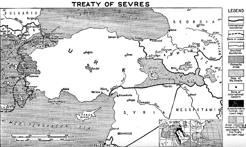
The current "self-made" map is inaccurate, as it describes all coloured regions as "zones", not noting the difference between the independent Armenian state, the proposed independent Kurdistan, the regions under Greek protectorate (Thrace and Smyrna), the Dodecanos annexed by Italy, and the various powers zones of influence within Anatolia itself. Also, the Kurdish "zone" is marked inaccurately as it included Diyarbakir in the French zone as well. Look here: http://www.nipissingu.ca/department/history/MUHLBERGER/uploaded_images/Map-color-Treaty-of-Sevres-748832.png
How can this be rectified? Str1977 (talk) 12:38, 18 September 2007 (UTC)
- I rectified it myself by uploading a new version of the map. Str1977 (talk) 22:34, 19 September 2007 (UTC)
Why are we not using the original map as it appeared in the treaty itself such as http://net.lib.byu.edu/~rdh7/wwi/versa/vmap7.gif ?--Kenneth Cooke (talk) 12:39, 21 June 2009 (UTC)
Because it is completely black and white and hard to make sense of, I guess, there seems to be good map of the treaty available in the whole internet! Akash (talk) 14:32, 3 May 2016 (UTC)
External links modified
Hello fellow Wikipedians,
I have just modified one external link on Treaty of Sèvres. Please take a moment to review my edit. If you have any questions, or need the bot to ignore the links, or the page altogether, please visit this simple FaQ for additional information. I made the following changes:
- Added archive http://web.archive.org/web/20050524215320/http://www.atlas-of-conflicts.com:80/areas/armenia-and-karabakh/turk_arm_war-1-1920.php to http://www.atlas-of-conflicts.com/areas/armenia-and-karabakh/turk_arm_war-1-1920.php
When you have finished reviewing my changes, please set the checked parameter below to true or failed to let others know (documentation at {{Sourcecheck}}).
This message was posted before February 2018. After February 2018, "External links modified" talk page sections are no longer generated or monitored by InternetArchiveBot. No special action is required regarding these talk page notices, other than regular verification using the archive tool instructions below. Editors have permission to delete these "External links modified" talk page sections if they want to de-clutter talk pages, but see the RfC before doing mass systematic removals. This message is updated dynamically through the template {{source check}} (last update: 5 June 2024).
- If you have discovered URLs which were erroneously considered dead by the bot, you can report them with this tool.
- If you found an error with any archives or the URLs themselves, you can fix them with this tool.
Cheers.—cyberbot IITalk to my owner:Online 04:41, 27 May 2016 (UTC)
Wilsonian Armenia relevancy
Tiptoethrutheminefield, are we sure we should be removing information concerning Wilsonian Armenia from this article? The territory concerning "the vilayets of Erzerum, Trebizond, Van and Bitlis" was to be placed under Wilsonian as specified in Article 89 of the Treaty of Sevres. We need to have at least some background information regarding that. Étienne Dolet (talk) 18:40, 6 June 2016 (UTC)
- The section is still there, if anyone want's to add accurate content. I removed the existing content only because I felt it was inaccurate, not because I thought there should be no content about this subject. However any wording or suggestion (such as the claim I removed, which was already fact tagged) that Armenia was actually given (or was ceded) specific territory under the text of the Treaty of Sevres would be false. The text of the treaty set up the arbitration procedure to decide on what (if any) territory would be transferred, and bound all the signing parties to abide by the arbitrator's final decision on this. Tiptoethrutheminefield (talk) 19:09, 6 June 2016 (UTC)
- I agree. But we should work together to add that information back into the article again, bearing in mind a more accurate picture though. Étienne Dolet (talk) 19:24, 6 June 2016 (UTC)
Inclusion of Turkish name
Hi what are everyone's views on this please? I added the Turksh name of the treaty to this article on the grounds that the treaty is about Turkey and anyone interested in knowing more might reasonably want to know what it was called in Turkish. Another editor has removed this info on the grounds that Turkish was not an official language of the treaty. This wasn't the reason for my including it in the first place and I'm not sure that matters very much. Should the Turksh term be in or out? Mccapra (talk) 16:55, 24 January 2017 (UTC)
External links modified
Hello fellow Wikipedians,
I have just modified one external link on Treaty of Sèvres. Please take a moment to review my edit. If you have any questions, or need the bot to ignore the links, or the page altogether, please visit this simple FaQ for additional information. I made the following changes:
- Added archive https://web.archive.org/web/20070629163221/http://www2.mfa.gr/NR/rdonlyres/3E053BC1-EB11-404A-BA3E-A4B861C647EC/0/1923_lausanne_treaty.doc to http://www2.mfa.gr/NR/rdonlyres/3E053BC1-EB11-404A-BA3E-A4B861C647EC/0/1923_lausanne_treaty.doc
When you have finished reviewing my changes, you may follow the instructions on the template below to fix any issues with the URLs.
This message was posted before February 2018. After February 2018, "External links modified" talk page sections are no longer generated or monitored by InternetArchiveBot. No special action is required regarding these talk page notices, other than regular verification using the archive tool instructions below. Editors have permission to delete these "External links modified" talk page sections if they want to de-clutter talk pages, but see the RfC before doing mass systematic removals. This message is updated dynamically through the template {{source check}} (last update: 5 June 2024).
- If you have discovered URLs which were erroneously considered dead by the bot, you can report them with this tool.
- If you found an error with any archives or the URLs themselves, you can fix them with this tool.
Cheers.—InternetArchiveBot (Report bug) 01:56, 22 March 2017 (UTC)
Signatory Caption Confusion
The caption of the photo of the signatories is confusing right now, but I'm not confident enough to know if it should be changed. Right now it talks separately about "the Ottoman education minister Bağdatlı Hadi Pasha" and "Ottoman Minister of Education Hadi Pasha". Claiming the former is in the picture and the latter is not.
Is this true? Or is perhaps either a title or name wrong here? — Preceding unsigned comment added by Rderdwien (talk • contribs) 10:22, 21 October 2019 (UTC)
Inacurate map
The map of Wilsonian Armenia is not correct: the original and correct map is this one: https://external-preview.redd.it/gQ2X5E4Y7QPnEHuqnAW7cZJM3CBBP55ovD6MI0lN3fo.jpg?width=960&crop=smart&auto=webp&s=0b47e27c4523aca76238a5435e7103a3a4381cd9 — Preceding unsigned comment added by Supétudiant (talk • contribs) 15:33, 13 November 2020 (UTC)
Sources
These sources are in further reading but can be the basis for a discussion of the "tripartite treaty":-
Toynbee, Arnold J. (1922). The Western Question in Greece and Turkey: A Study in the Contact of Civilisations (PDF). Constable and Company Ltd. p. 75 et seq. Selfstudier (talk) 09:51, 5 July 2021 (UTC)
The Making of the Treaty of Sevres of 10 August 1920 A. E. Montgomery Journal:The Historical Journal Volume:15 DOI:10.2307/2638042 Date:December, 1972 https://www.jstor.org/stable/2638042 Selfstudier (talk) 09:56, 5 July 2021 (UTC)
For the separate Greece-Turkey treaty regarding about the Aegean Islands, a good source is Joseph Roucek (1944). "The Legal Aspects of Sovereignty Over the Dodecanese". The American Journal of International Law. 38: 701–706. Zerotalk 11:33, 5 July 2021 (UTC)
Sèvres map discussion
This map is completely fake. It was canceled even though I put the correct one. I showed the evidence, but it was deleted. Because I was asked to cite too many sources. The first source is the text of the treaty itself. Is there a better resource than this? In which article of the treaty the zone of influence given for Italy and France is written, please someone show me. No one here has read the treaty even once.
This is the correct map of the treaty.
https://commons.wikimedia.org/wiki/File:The_Treaty_of_S%C3%A8vres_1920_-_English.png
Want to look at other maps?
https://www.info-grece.com/encyclopedia/traite-de-sevres-1920
http://aujourdhuilaturquie.com/fr/le-proche-orient-du-traite-de-sevres-a-nos-jours/
https://www.memoiresdeguerre.com/article-traite-de-lausanne-1923-107400884.html
https://www.revueconflits.com/turquie-traite-sevres-armenie-histoire-lausanne/
https://mindthemap.fr/empire-ottoman-traite-de-lausanne-1923/
https://campusnumeriquearmenien.org/ressources/details/1400
Please someone show me in which article the zone of influence given to Italy and France is written?
Or is it the never-implemented Sykes-Picot project shown on the map in this article? https://russiancouncil.ru/en/analytics-and-comments/analytics/nuzhno-li-prisoedinyat-rossiyu-k-soglasheniyu-sayksa-piko/
In short, we are faced with a great misunderstanding. Luisao Araujo (talk) 13:50, 27 June 2021 (UTC)
- Luisao Araujo I have moved your discussion here as this would be the correct place, while I understand you mean well, you are doing it the wrong way. You shouldn't have added your map across multiple language project before discussing it, and discussions aren't just between you and me and don't end in 1-2 days. That's why I'm removing it.
I will ask you to revert all of your map edits until we establish consensus that your map is better. I don't to comment on your lack of knowledge on Wikipedia policies. Just please read these article on how things work here; WP:V, WP:RS, WP:BRD, WP:OR, WP:SYNTH. I don't have anything against you, but we shouldn't replace a good map with a seemingly inferior one. Also seek further input from other users, I'm not the only editor on this site. - Kevo327 (talk) 10:53, 29 June 2021 (UTC)
- also read WP:BURDEN, because you are the who should "prove their claims before getting reported to the authorities", and not me. - Kevo327 (talk) 10:57, 29 June 2021 (UTC)
I undid the map replacements where I found them, agree we should seek a consensus as to whether the new map is a good replacement for the old...or not. We should investigate the sources some more.Selfstudier (talk) 11:00, 29 June 2021 (UTC)
- Selfstudier, you might as well revert the map replacements on the other wikis until we reach a consensus. File:The Treaty of Sèvres 1920 - English.png. The articles are listed in the bottom of the page. - Kevo327 (talk) 13:32, 29 June 2021 (UTC)
- I reverted all the English Wikipedia replacements.Selfstudier (talk) 14:06, 29 June 2021 (UTC)
This map is unsatisfactory as it has multiple unexplained colors. It also has labels "French Zone" and "Italian Zone" which are dubious. The treaty mentions some islands to be ceded to Italy but it doesn't mention any territorial gain for France that I can see. Perhaps these designations refer to zones of occupation at the end of WWI rather than stipulations of the treaty. In general I think Luisao Araujo has a case worth hearing even though he didn't go about this the right way. Zerotalk 15:12, 29 June 2021 (UTC)
- and hear him we shall, discussion for improvement is always welcome. but till consensus is reached the old maps stay. - Kevo327 (talk) 16:38, 29 June 2021 (UTC)
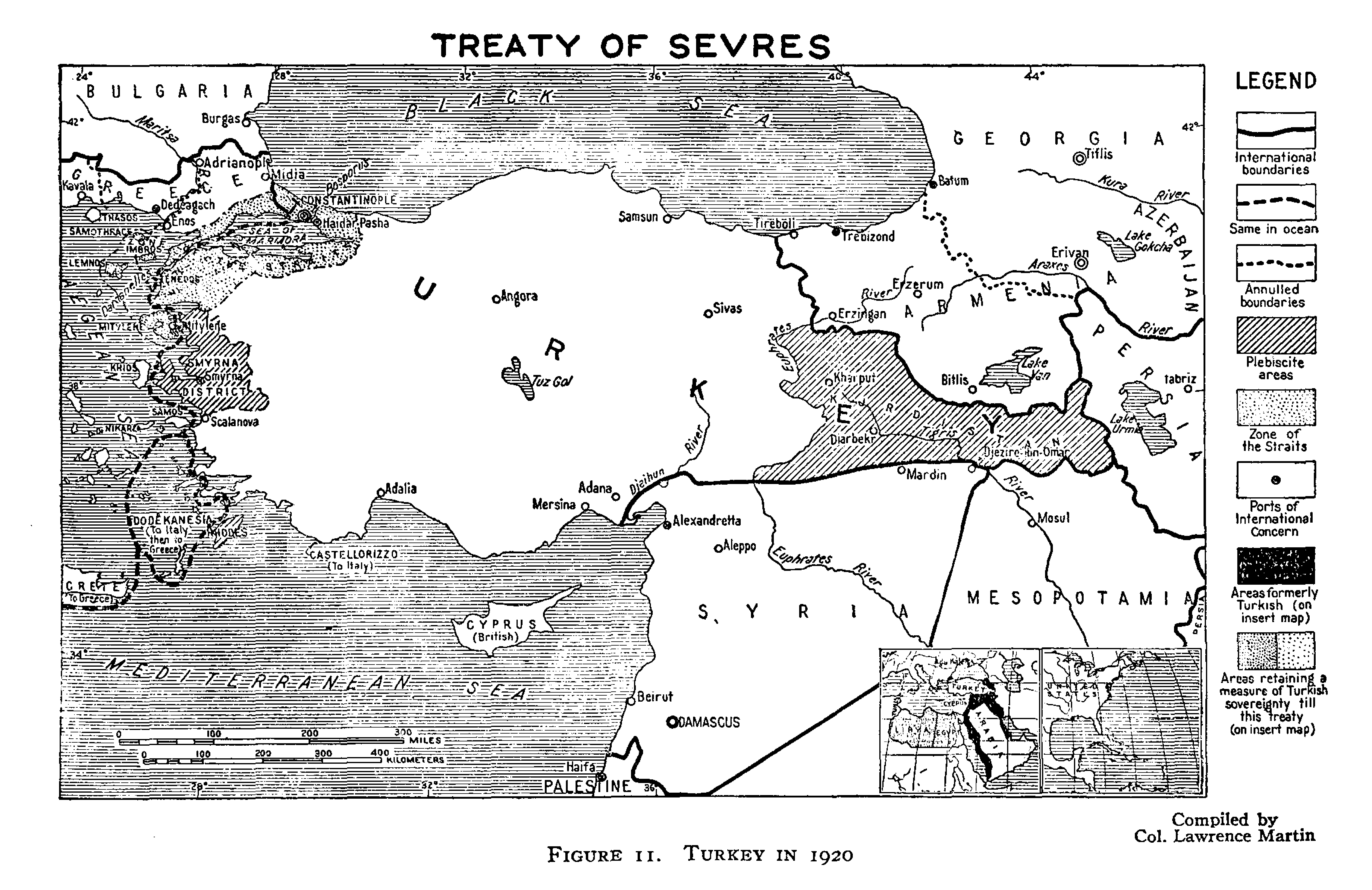
Ok, after investigation I can say for sure that the map in the infobox does not show what it claims. Most of the colored regions are zones of influence under the post-WWI occupation regime. They are not regions defined by the treaty. I also found higher-res (i.e. readable) versions of the three b/w maps that were published with the treaty in Treaties of Peace. I will upload them to commons on top of the low-res versions. I will also make a colored map based on those. Stay tuned. Zerotalk 05:03, 30 June 2021 (UTC)
- pinging buidhe as this discussion might be of interest to them. - Kevo327 (talk) 07:23, 30 June 2021 (UTC)
I have uploaded larger versions of three maps that appeared along with the text of the treaty in Treaties of Peace, 1919-1923, compiler Lawrence Martin, Carnegie Endowment for International Peace, 1924. As always you might need to aggressively clear your cache before the new versions appear. They are:
- Overview. Full size
- Eastern region. Full size
- Armenian region. Full size. This is labeled "President Wilson's Armenian Boundary" (see the article for what this means).
Zerotalk 07:38, 30 June 2021 (UTC)
- I'm holding off making a new map for now. There remains the question of what to show, for example should modern boundaries appear? Zerotalk 07:47, 30 June 2021 (UTC)
- Don't show modern boundaries. That's just projecting the current scenario back into the past before it existed. (t · c) buidhe 08:23, 30 June 2021 (UTC)
- I'm holding off making a new map for now. There remains the question of what to show, for example should modern boundaries appear? Zerotalk 07:47, 30 June 2021 (UTC)
Once there is a decision on the map(s) I have a source for a bit of a write-up on the connection between Sykes-Picot and Sevres, apart from the obvious fact that neither was implemented as imagined.Selfstudier (talk) 09:18, 30 June 2021 (UTC)

Selfstudier buidhe Onceinawhile Kevo327 Luisao Araujo. Here is the first draft of a map based on the 1924 maps mentioned by me above. Please critique. Zerotalk 08:17, 3 July 2021 (UTC)
I said this from the very beginning.
There is no clause in the Treaty of Sevres on zones of influence. If a second agreement has been made regarding this and there are these articles, then that agreement and its articles should be shown. It must be disclosed. And I want to read all the clauses in that agreement.
And this information should be stated separately under this title.
So it should be said: "At the date of the signing of the Treaty of Sevres, some zones of influence were defined by a second treaty. According to this treaty, this zones was left to Italy and the other region to France." Something like that.
- Do you refer here to the tripartite agreement (British, French and Italian)? Selfstudier (talk) 10:24, 4 July 2021 (UTC)
- @Selfstudier: The article attributes the provisions of the tripartite agreement to the main treaty, which is wrong. Actually there are many wrong statements in the article. Zerotalk 13:44, 4 July 2021 (UTC)
- Yep, needs a rework. The special interests existed but they are not of the extensive type that existed in prior agreements, worth mentioning but not mapping.Selfstudier (talk) 14:34, 4 July 2021 (UTC)
No. Some people say that apart from the Treaty of Sevres, a different document signed on the same day defines these zones of influence. In this case, then, I say that, they should show that document and its articles.Luisao Araujo (talk) 11:11, 4 July 2021 (UTC)
- The tripartite agreement was signed on the same day and speaks about "the special interests of France and Italy" (I provided a link to this document in the external links section).Selfstudier (talk) 11:46, 4 July 2021 (UTC)
- @Selfstudier: The article has this wrong.
- The tripartite agreement was signed on the same day and speaks about "the special interests of France and Italy" (I provided a link to this document in the external links section).Selfstudier (talk) 11:46, 4 July 2021 (UTC)
Shall I show you an American source published in 1921?
https://archive.org/details/literarydigestat00upde_0/page/22/mode/2up
This is Greece according to the Sevres.
https://archive.org/details/literarydigestat00upde_0/page/28/mode/2up
And this is Turkey according to the Sevres.
You can also zoom in on the map.
Here are the real maps.
However, on the other hand, I must state that a person who talks about zones of influence should also indicate in which treaty it is, in which article it is written, its definition, the area it covers and the applicable principles. And moreover, between whom was this treaty signed?
On the map in the article, Turkey only appears to consist of the Yellow region. You are aware of that, right? This is the impression the map gives to people.
Unless the mentioned second treaty and its articles are shown and the areas of influence are proven, this information is wrong.
The plaintiff is obliged to prove his claim.
I consulted a historian professor I know closely about this issue. He said that it was mentioned in many places, but he could not find the mentioned zones of influence and such an agreement. He said this was an unproven claim and seemed more like fabricated information.
And I said what I needed to say. I have nothing to add for now.
You will make the decision. I wish you all good work.
Luisao Araujo (talk) 10:03, 3 July 2021 (UTC)
- @Luisao Araujo: You need to pay more attention to the discussion. I just made a map with no "zones of influence" and I propose to put it in the article in place of the existing map. It agrees with the maps you linked to. Yet you continue to argue against zones of influence. That's called "flogging a dead horse". Zerotalk 10:13, 3 July 2021 (UTC)
- @Zero0000:
There is an error on the map. The island of Rhodes was given to Italy. But on condition that a plebiscite is held after 15 years.
And if you can, I would recommend making the Turkish side of the zone of the straits partly orange and the Greek part partly purple. This will be more accurate.
And my advice is you can show Greece with light Blue color, Turkey with Red color, Italian or French region with blue color. This way it will be more understandable.
In general, your map is successful.
Luisao Araujo (talk) 11:37, 3 July 2021 (UTC)
I can recommend you to show the Zone of the Straits as on this map.
Luisao Araujo (talk) 11:42, 3 July 2021 (UTC)
Zero0000, the map seem sgood overall but I have a couple suggestions for it:
- changing Erivan -> Yerevan which is the common name of the city as the Persian name had fallen into disuse by the date of the treaty.
- adding a couple of cities on the like Ankara and Trebizon. - Kevo327 (talk) 12:15, 3 July 2021 (UTC)
after looking a bit more into the map, Armenia's other borders should be better defined and the colour should be different from the neighbouring countries, as Armenia was independent in August 1920 when the treaty was signed, while the sovietization was in December 1920. (see First Republic of Armenia) - Kevo327 (talk) 13:22, 3 July 2021 (UTC)
- Zero0000 great map thank you for creating it. I have four suggestions:
- The original map you posted has the T of Turkey in the Zone of the Straits. Presumably they considered that zone still part of Turkey-widely-defined? I am not sure, but if this is the case then maybe we shouldn’t define Turkey as the smaller area
- I didn’t see the borders of the Plebscite area demarcated? Is Kurdistan mentioned in the treaty?
- Is there a way of deemphasizing those areas which were not impacted? Ie Persia, Bulgaria
- Was Armenia to become part of the USSR? Is so perhaps we should add a label of sorts
- Onceinawhile (talk) 13:12, 3 July 2021 (UTC)
- Zero0000 great map thank you for creating it. I have four suggestions:
Thank you all for your suggestions, but if I implement all of them the map will be unreadable. I'll choose sparingly. Regarding Rhodes, the plebiscite is not in the Treaty of Sèvres at all. It is in "Treaty between Greece and Italy relative to Sovereignty over the Aegean Islands" signed in Paris on the same day. That separate treaty is also where Italy agreed to hand the rest of Dodekahesia to Greece after acquiring it from Turkey. I have a copy of it. I must add this information to the article. Kurdistan (which I will color) was granted local autonomy with an option to petition the League of Nations for independence after one year with no guarantee of success. A plebiscite is not mentioned, but evidence of majority support for independence must be provided. Zerotalk 13:49, 3 July 2021 (UTC)
The Zone of the Straits was divided between Greece and Turkey where the international borders are shown. It is indicated on maps because the Treaty has a large number of special provisions for it, Articles 37–61 and some scattered Articles. Zerotalk 13:55, 3 July 2021 (UTC)
Regarding Armenia, the reason the other borders are not shown is that they weren't defined. This map shows an area as "area given to Armenia by the Treaty of Sèvres" but that is incorrect. Also note the big difference between that map and the map at Democratic Republic of Georgia. What the Sèvres Treaty says (Article 92) is "The frontiers between Armenia and Azerbaijan and Georgia respectively will be determined by direct agreement between the States concerned", with the Principal Allied Powers making the decision if those States can't agree by the time the Turkey-Armenia boundary is determined. Exactly when those other boundaries were determined I don't know, but they weren't determined in the Treaty or by the time of the Treaty. Zerotalk 14:18, 3 July 2021 (UTC)
The USSR did not exist until 1922 and there is no mention of Armenia having a particular relationship with Russia. The Treaty says that Armenia will be a "free and independent state". Zerotalk 03:53, 4 July 2021 (UTC)
New version
Here is a new edition (refresh the page until you see Ankara in the middle of Turkey). I added a bunch of cities and renamed Yerevan. I colored the Zone of the Straits according to sovereignty. I marked the areas subject to plebiscite or similar (incorporating the Greco-Italian treaty). The case of Smyrna is too complicated to represent on a map. It was under Turkish sovereignty but Greek governance and there was a Commission established. Zerotalk 04:16, 4 July 2021 (UTC)
The map is successful, but the color choices seemed a bit strange to me.
It might be better if you show Greece with any blue tint and Turkey with any Red tint. And maybe if you show İzmir (Smyrna) in yellow, it will be more emphatic. Finally, I might ask you to show mesopotamia and Cyprus the same color. Because both belonged to the British.
Or, instead of all these, you can only show Turkey with yellow color.Luisao Araujo (talk) 07:12, 4 July 2021 (UTC)
I adjusted colors again and made some other minor tweaks. The Greek portion has Adianople if you are viewing the newest edition. Cyprus and Mesopotamia are now the traditional British red. Turkey is lighter but I see no problem with it otherwise. I propose to put it in the article now. Zerotalk 08:55, 5 July 2021 (UTC)
- Looks good, I made the switch at Sykes–Picot Agreement.Selfstudier (talk) 09:14, 5 July 2021 (UTC)
I think this map is successful and accurate. This should be the map that should be put in the article.
The issue of spheres of influence is an agreement between England, France and Italy, and according to this agreement, British and French companies will not enter the region where Italian companies will operate. Likewise, there would be no English and Italian companies in the region where French companies were located. In other words, this treaty was intended to prevent conflicts between allies. The administration of the region belonged to the Turkish government.
I think these domains should be specified separately and have a separate map in the article. Again, according to this treaty, England, France and Italy had to withdraw their troops from Turkey, including their spheres of influence.
It should not be on the main map of the Treaty of Sevres. This should be stated as additional information in the article. Because someone who looks at that map thinks that the half of Turkey belongs entirely to Italy and France.Luisao Araujo (talk) 15:19, 5 July 2021 (UTC)
I replaced the map in the infobox. Next, I want to remove the 1927 map in old Turkish script. I don't think it adds anything more than mystery to the article. Who will disagree? Zerotalk 01:47, 6 July 2021 (UTC)
I agree with you. Luisao Araujo (talk) 10:16, 6 July 2021 (UTC)
No objection.Selfstudier (talk) 10:50, 6 July 2021 (UTC)
New map for the article
What is a problem? I didn't replace your old map in the section, even it's obvious this map:
, is way more better. Old English map look like a drawn plan of the new borders, rather than a map of independent country. It's always welcomed in Wikipedia, to add new and better illustrations in the articles.Culminatio (talk) 13:53, 25 July 2021 (UTC)
- Culminatio, new maps are always welcome when they are factually correct, the map that you are adding is an original work unrelated to the treaty, the treaty didn't demarcate the borders of the three states. - Kevo327 (talk) 16:24, 25 July 2021 (UTC)
- I would still like to know what is the connection between this map and https://commons.wikimedia.org/wiki/File:Treaty_of_Kars_1921(ARMENIA_GEORGIA_AZERBAIJAN).jpg? In any case, 3 editors have reverted this inclusion so you need to do more work if you want this in. There must have been some context for this map in the source publication, what was it? Selfstudier (talk) 17:01, 25 July 2021 (UTC)
- Unfortunately even maps of the same treaties are different, probably reflecting nationalistic wishful thinking. In the case of this map, only the border between Armenia and Turkey is relevant to this article. Zerotalk 09:22, 26 July 2021 (UTC)
.jpg)