This is the talk page for discussing improvements to the Vlad the Impaler article. This is not a forum for general discussion of the article's subject.
The subject of this article is controversial and content may be in dispute. When updating the article, be bold, but not reckless. Feel free to try to improve the article, but don't take it personally if your changes are reversed; instead, come here to the talk page to discuss them. Content must be written from a neutral point of view. Include citations when adding content and consider tagging or removing unsourced information.
This article is within the scope of WikiProject Biography, a collaborative effort to create, develop and organize Wikipedia's articles about people. All interested editors are invited to join the project and contribute to the discussion. For instructions on how to use this banner, please refer to the documentation.BiographyWikipedia:WikiProject BiographyTemplate:WikiProject Biographybiography articles
This article is within the scope of WikiProject European history, a collaborative effort to improve the coverage of the history of Europe on Wikipedia. If you would like to participate, please visit the project page, where you can join the discussion and see a list of open tasks.European historyWikipedia:WikiProject European historyTemplate:WikiProject European historyEuropean history articles
This article is within the scope of the Military history WikiProject. If you would like to participate, please visit the project page, where you can join the project and see a list of open tasks. To use this banner, please see the full instructions.Military historyWikipedia:WikiProject Military historyTemplate:WikiProject Military historymilitary history articles
This article is within the scope of WikiProject Middle Ages, a collaborative effort to improve the coverage of the Middle Ages on Wikipedia. If you would like to participate, please visit the project page, where you can join the discussion and see a list of open tasks.Middle AgesWikipedia:WikiProject Middle AgesTemplate:WikiProject Middle AgesMiddle Ages articles
This article is within the scope of WikiProject Romania, a collaborative effort to improve the coverage of Romania-related topics on Wikipedia. If you would like to participate, please visit the project page, where you can join the discussion and see a list of open tasks.RomaniaWikipedia:WikiProject RomaniaTemplate:WikiProject RomaniaRomania articles
This article was copy edited by Corinne, a member of the Guild of Copy Editors, on 13 December 2016.Guild of Copy EditorsWikipedia:WikiProject Guild of Copy EditorsTemplate:WikiProject Guild of Copy EditorsGuild of Copy Editors articles
Laszlo Panaflex, what's wrong with the new map, is it too big? How do you suggest I fix it? NeimWiki (talk) 22:21, 18 August 2023 (UTC)[reply]
It is far too large, sandwiching text down to a few words per line. Please see MOS:IMGSIZE for guidance on image sizing. Laszlo Panaflex (talk) 22:27, 18 August 2023 (UTC)[reply]
Also, text should not be sandwiched between two images, there is no need for AD (WP:BCE) and a caption does not take a period unless it is a complete sentence (MOS:CAPFRAG). Aligning the map with the second paragraph also places it next to the pertinent text. Laszlo Panaflex (talk) 22:39, 18 August 2023 (UTC)[reply]
Hi NeimWiki, that map is incorrect again. We had several discussions before regarding many wrong maps.
At the above link I showed many international academic maps. Please fix that map! OrionNimrod (talk) 23:54, 18 August 2023 (UTC)[reply]
How about you read the page we're on before claiming a map is incorrect? NeimWiki (talk) 07:50, 19 August 2023 (UTC)[reply]
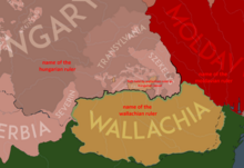
South Transylvania clearly was not part of Wallachia as it is your maps, 1390s, 1450s, 1460s. Where do you get this? Also I do not know what is the small yellow and red patches inside Hungary, what is the source for that patches?
Do you deny the international academic maps? Even on all academic Hungarian history maps that region is part of Hungary. We should follow academic maps not our fantasy painting. OrionNimrod (talk) 10:06, 19 August 2023 (UTC)[reply]
Hi @NeimWiki, It seems you have understanding problem what the medieval feudal fief means. If Romanian voivodes got Transylvanian fiefs in the 14th century from the Hungarian king it does not mean that region became part of Wallachia. The Hungarian king donated his land which belonged to the Hungarian crown = the Hungarian king was the overlord of those people who got properties from him = that land was still part of the Hungarian crown. But in 1464 Matthias Corvinus took it out of their hands and gave it to János Geréb, the later voivode of Transylvania. Which means, we can see again who was the overlord = the region was part of the Hungarian crown.
However it is interesting me, on your medieval maps only Hungary is feudal fragmented but Wallachia and Moldavia not. You want to show that Fogaras was the property of the Wallachian voivode, following your logic Wallachia should colored as Hungary because Hungary was the overlord of Wallachia (many times at that time).
It was also many personal union in history, like King Louis was the king of Poland and Hungary, and it does not mean the 2 countries were united. OrionNimrod (talk) 17:36, 21 August 2023 (UTC)[reply]
Hi, NeimWiki, I see you want to show in any case that regions were Wallachian fiefs: It consisted of a form of property holding or other rights granted by an overlord to a vassal, who held it in fealty or "in fee" in return for a form of feudal allegiance, services, and/or payments. = that land was part of the Kingdom of Hungary, and it is a history falsification that you detach clearly that region from Hungary.
If English nobles had fiefs in the land of the French crown in France it does not mean that region was part of England, or if French nobles had fiefs on the land of English crown in England, it does not mean that region was part of France.
I suggested a solution, I draw a fast example, you need empasize the state borders, and you colorize fiefs inside Hungary, it would be good to add captions for better understanding, like the other example map the orange region is clearly marked as "fief by Mircea as Hungarian vassal" = fiefs on the Hungarian crown land.
Btw why only Hungary is feudal fragmented on your maps???
Dude, stop removing my maps or I'll have to report you. Your inabilitity to understand how feudalism worked should not be my problem.
As I've previously explained to you, Fagaras and Amlas were Wallachian possessions inside of Transylvania at verious time periods, often given to the Voivode by the King of Hungary. Same goes for the Moldavian possessions of Ciceu and Balta. The Hungarian king exchanged these territories initially as compensation for the Voivode's subordination. This was not the case for Vlad the Impaler, who claimed and exercised his rule in Fagaras and Amlas, and had Matthias, his future ally, ask his Saxon vassals to refrain from antagonising him, which you would have realised had you read the very article of this talk page.
My maps show a clear distinction between Walachia and the Duchy of Fagaras and Amlas, as they're not only labeled separately but also have their own borders, nobody with good eyesight would mistake Fagaras for a Wallachian province.
I do not see the need to continue this discussion, as you refuse to accept anything I'm saying while claiming I don't "recognise international academic maps" and that what I'm showing are "fantasy paintings". If you can actually find written sources, not a map you saw one time (like you've presented me so far), which mention Vlad as a vassal of Matthias Corvinus in 1457 and 1461, I'll happily edit my maps to show it. NeimWiki (talk) 15:59, 22 August 2023 (UTC)[reply]
Please report me, that I remove your own photoshopped maps which are not matching with academic history maps. It is a clear history falsification that you detach south Transylvania and patches from medieval Hungary to Wallachia. It is a clear history falsification that you show patches inside Hungary as Ottoman vassal area.
"Wallachian possessions inside of Transylvania" = fiefs which was given by the Hungarian king as overlord to their vassals and that regions were part of the Hungarian crown, ie the Kingdom of Hungary
"The regions are outlined as Ottoman vassals in https://commons.wikimedia.org/wiki/File:1457VOIVODATE.png because they were Wallachian holdings," No, the region was part of the Hungarian crown and the lands was given as fief estate to the Wallachian ruler by the Hungarian overlord, that region was not an Ottoman vassal area. Did you not hear about the dual suzerainty? I suggested a solution which show the Wallachian fiefs as part of Hungarian crown as it was. OrionNimrod (talk) 16:08, 22 August 2023 (UTC)[reply]
Semi-protected edit request on 24 January 2024[edit]
This edit request has been answered. Set the |answered= or |ans= parameter to no to reactivate your request.
delete "Doğrugöz" and correct the name as "Eğrigöz, Emet".
There were two Eğrigöz cities in Turkey. The one mentioned here is not the correct one and it seems that there is a confusion. Vlad the Impaler was kept in the castle of Eğrigöz, Emet. ( More details can be also found here: https://tr.wikipedia.org/wiki/E%C4%9Frig%C3%B6z,_Emet) . The other one does not even have a castle and changed its name later on. Toprak77 (talk) 07:51, 24 January 2024 (UTC)[reply]
Language of medieval Slavic work of “The Tale of Dracula the Voievode”[edit]
The language of this Tale is undoubtedly Old Russian rather than South Slavic, as some Romanian authors believe and as stated in this article. Moreover, the ideological content of the work corresponds strictly to Russian themes. More information on this can be found here:


 Done
Done