Taxat-Senat
Taxat-Senat | |
|---|---|
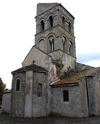
 The church in Senat | |
| Coordinates: 46°12′06″N 3°08′20″E / 46.2017°N 3.1389°E | |
| Country | France |
| Region | Auvergne-Rhône-Alpes |
| Department | Allier |
| Arrondissement | Vichy |
| Canton | Gannat |
| Intercommunality | Saint-Pourçain Sioule Limagne |
| Government | |
| • Mayor (2020–2026) | Jean-Philippe Guittard[1] |
Area 1 | 13.62 km2 (5.26 sq mi) |
| Population (2022)[2] | 211 |
| • Density | 15/km2 (40/sq mi) |
| Time zone | UTC+01:00 (CET) |
| • Summer (DST) | UTC+02:00 (CEST) |
| INSEE/Postal code | 03278 /03140 |
| Elevation | 267–406 m (876–1,332 ft) (avg. 273 m or 896 ft) |
| 1 French Land Register data, which excludes lakes, ponds, glaciers > 1 km2 (0.386 sq mi or 247 acres) and river estuaries. | |
Taxat-Senat is a commune in the Allier department in Auvergne-Rhône-Alpes in central France. It is located 16.5 kilometres (10.3 mi) northwest of Gannat along the D223 road, northwest of Charroux, southwest of Chezelle, west of Ussel-d'Allier and northeast of Bellenaves and Naves.[3][4]
Population
[edit]| Year | Pop. | ±% p.a. |
|---|---|---|
| 1968 | 321 | — |
| 1975 | 274 | −2.24% |
| 1982 | 239 | −1.93% |
| 1990 | 213 | −1.43% |
| 1999 | 210 | −0.16% |
| 2009 | 226 | +0.74% |
| 2014 | 223 | −0.27% |
| 2020 | 189 | −2.72% |
| Source: INSEE[5] | ||
Economy
[edit]As of 2020, the working age population was 117 people, of which 74% were active (7% unemployed) and 26% were inactive (11% retired, 10% students).[6]
Sights
[edit]The commune contains the Église romane Saint-André de Taxat,[7] dated to the twelfth century with rich frescoes of the fourteenth century.[8] It is listed on the Supplementary List of Historic Monuments and is partly ruined,[9] especially the floor of the nave and is subject to a restoration plan. The other church, Église de Senat, the parish church, has an apse and bell tower which are also on Supplementary List of Historic Monuments.[10]
Personalities
[edit]- Hubert Pradon-Vallancy (1891–1943), Deputy of the Allier Department from 1928 to 1932. He was born in the Château de Mont in Taxat-Senat and was also mayor of Taxat-Senat.
See also
[edit]References
[edit]- ^ "Répertoire national des élus: les maires" (in French). data.gouv.fr, Plateforme ouverte des données publiques françaises. 13 September 2022.
- ^ "Populations de référence 2022" (in French). The National Institute of Statistics and Economic Studies. 19 December 2024.
- ^ Fanaud, Lucien (2005). Voies romaines et Vieux Chemins en Bourbonnais. Editions de Borée. p. 231. ISBN 978-2-84494-006-3. Retrieved 30 May 2012.
- ^ Maps (Map). Google Maps.
- ^ Population en historique depuis 1968, INSEE
- ^ Population active, emploi et chômage au sens du recensement en 2020, INSEE
- ^ Courtillé, Anne (1997). Marie En Auvergne, Bourbonnais Et Velay. Editions de Borée. p. 91. ISBN 978-2-908592-56-6. Retrieved 30 May 2012.
- ^ Génermont, Marcel; Pradel, Pierre (1938). Allier. Letouzey et Ané. p. 266. Retrieved 30 May 2012.
- ^ Grégoire, C., Le Canton de Chantelle [Canton of Chantelle], 1910; reprinted as Chantelle (et ses environs) [Chantelle and its surroundings], coll. « Monographies des villes et villages de France » (Micberth), Paris, Res Universis, 1990, pp. 297–317.
- ^ Sauvegarde de l'art français (Association) (1979). La Sauvegarde de l'art français. Picard. p. 198. ISBN 978-2-7084-0481-6. Retrieved 30 May 2012.


