
Testa, Zanskar
Testa
Tetha | |
|---|---|
village | |
 Testa village from the south | |
 Testa | |
| Coordinates: 33°10′42″N 77°10′00″E / 33.1782023°N 77.1666792°E | |
| Country | |
| State | Ladakh |
| Area | |
| • Total | 1.71 km2 (0.66 sq mi) |
| Elevation | 3,980 m (13,060 ft) |
| Population (2011) | |
| • Total | 460 |
| • Density | 270/km2 (700/sq mi) |
| Languages | |
| Time zone | UTC+5:30 (IST) |
| Postal Index Number | 194302 |
| Website | https://kargil.nic.in/ |
Testa (also Tetha) is a small village in the Lungnak valley in Zanskar tehsil, Kargil district, Ladakh, India. The village is situated on a plateau at the base of a mountain range on the right bank of the Kargiakh River. It is located on a rural road that runs on the right bank opposite the Padum-Darcha road. Testa is 61 km (38 mi) south from Padum.
Description
[edit]Testa (elevation 3,980 m (13,060 ft)[1]) is a small village in the Lungnak valley on the right bank of the Tsarap River. It is located at a distance of 61 km (38 mi) from Padum on the Padum-Darcha road.[2] The distance from Darcha in Lahaul is 68 km (42 mi), the road climbing over the 5,091 m (16,703 ft) Shinko La pass. Testa village has an area of 170.80 hectares (422.1 acres).[3]: 80
Demographics
[edit]
The population as of the 2011 Census was 460 with 71 households. Females comprised 48.5% of the population. The literacy rate was 53%. 97.4% of the inhabitants belonged to scheduled tribes.[3]: 80-81 The pre-dominant religion is Buddhism.[4]: 48
Amenities
[edit]Testa has pre-primary, primary and middle schools. It has a dispensary, it is served by a mobile phone operator and electricity supply is available.[4]: 147-149,151
Economy
[edit]
The economy is largely agrarian with tourism also providing jobs and income. Annual precipitation is low, fields are irrigated through channels from streams fed by snow-melt.[5] In 2011, 47% of the cultivated land was irrigated.[4]: 152
Transport
[edit]In June 2024, the Himachal Road Transport Corporation (HRTC) announced that it would soon commence a bus service from Keylong in Lahaul to Padum. This would run on the Nimmu-Padum-Darcha road and would serve Testa.[6]
Tourism
[edit]Testa is a way-point on the popular Darcha-Padum trek. This trek of moderate difficulty takes 9-10 days. It crosses the 5,091 m (16,703 ft) Shinko La pass, then alternates on the left and right sides of the Lungnak valley. A day hike in the middle is a visit to Phuktal Gompa.[7] With the completion of the Darcha-Padum road, this trek has lost its appeal.[citation needed]
Gallery
[edit]-
 Kargiakh river and Testa plateau from the right bank
 -
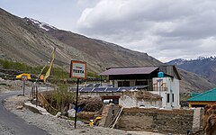 Testa sign on the left bank road
 -
 Willow and birch trees
 -
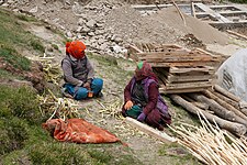 Stripping bark from willow sticks
 -
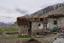 Traditional house
 -
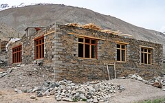 Modern house under construction


See also
[edit]References
[edit]- ^ "Node: Testa". OpenStreetMap. March 2024. Retrieved 28 July 2024.
- ^ "Padum - Testa route". OpenStreetMap. 28 July 2024. Retrieved 28 July 2024.
- ^ a b District Census Handbook: Kargil, Jammu & Kashmir -- Village and Town Wise Primary Census Abstract (PCA). 3 Part XII B. Directorate of Census Operations, Himachal Pradesh, Ministry of Home Affairs, Govt of India. 2011.
- ^ a b c District Census Handbook: Kargil, Jammu & Kashmir -- Village and Town Directory. 2 Part XII A. Directorate of Census Operations, Himachal Pradesh, Ministry of Home Affairs, Govt of India. 2011.
- ^ "Kargil - Ladakh: The climate and soil condition of the district". LAHDCK – Ladakh Autonomous Hill Development Council, Kargil. 13 July 2024. Retrieved 24 July 2024.
- ^ Tribune News Service (22 June 2024). "Keylong-Padum trial run a success, service on anvil". The Tribune (India). Retrieved 21 July 2024.
- ^ Mahanta, R. (2011). "The Complete Guide to Darcha Padum Trek". India Hikes. Retrieved 28 July 2024.