
The Blue Mountains, Ontario
The Blue Mountains | |
|---|---|
| Town of The Blue Mountains | |
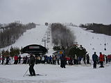
 Town of The Blue Mountains viewed from the top of Blue Mountain | |
 The Blue Mountains  The Blue Mountains | |
| Coordinates: 44°29′N 80°23′W / 44.483°N 80.383°W | |
| Country | Canada |
| Province | Ontario |
| County | Grey |
| Formed | January 1, 2001 |
| Government | |
| • Mayor | Andrea Matrosovs |
| • Federal riding | Simcoe—Grey |
| • Prov. riding | Simcoe—Grey |
| Area | |
| • Land | 287.24 km2 (110.90 sq mi) |
| Population (2016)[1] | |
| • Total | 7,025 |
| • Density | 24.5/km2 (63/sq mi) |
| Time zone | UTC-5 (EST) |
| • Summer (DST) | UTC-4 (EDT) |
| Postal Code | N0H 2P0 |
| Area code | 519 & 226 |
| Highways | |
| Website | www.thebluemountains.ca |
The Blue Mountains is a town in Grey County, southwestern Ontario, Canada, located where the Beaver River flows into Nottawasaga Bay. It is named for the Blue Mountain, and hence the economy of the town is centred on tourism, particularly on the Blue Mountain ski resort and the private Georgian Peaks, Osler, Craigleith and Alpine Ski Clubs.
The town was formed on January 1, 2001, when the Town of Thornbury was amalgamated with the Township of Collingwood. Thornbury is home to the architecturally unique L.E. Shore Memorial Library, named after the founding partner of the architectural practice of Shore Tilbe Irwin + Partners, and designed by the firm.
During the Southern Ontario Tornado Outbreak of 2009, a tornado passed through the Blue Mountains area on August 20. The tornado passed by Thornbury and hit Craigleith before moving out onto Georgian Bay.
Ravenna is the setting for the novel Ravenna Gets by author Tony Burgess.[citation needed]
Recreation[edit]
The Blue Mountains has a host of recreational activities for all the seasons. Most notably is the winter skiing, snowboarding, snowshoeing and cross-country skiing. In the summer there is hiking, downhill/cross-country biking, an extravagant mini putt,[2] the Ridge Runner[3] and events such as Met Con Blue.[4] If physical activities are not what you are looking for, The Village at Blue Mountain[5] has a plethora of boutiques, coffee shops, restaurants, hotels and chalets, as well as golf courses within walking distance. Less than a 5-minute drive away there is the Scandinave Spa[6] which situated on 25 acres of natural Ontario birch, as well as the Scenic Caves.[7]
Craigleith Provincial Park is located along Highway 26 near Blue Mountain resort.
The Bruce Trail passes through sections of the town. The Kolapore area for mountain biking and cross-country skiing, Metcalfe Rock which is popular with rock climbers as well as the Duncan Crevice Caves Nature Reserve are in the area as well.
Communities[edit]


The primary population centres are Thornbury and the modern resort-style communities clustered around the foot of the escarpment near the ski resorts. Additionally the town's territory also includes the rural communities of Banks, Camperdown, Castle Glen Estates, Christie Beach, Clarksburg, Craigleith, Duncan, Gibraltar, Swiss Meadows, Heathcote, Kolapore, Little Germany, Lora Bay, Loree, Ravenna, Red Wing, Slabtown, and Victoria Corners.
Thornbury[edit]
Thornbury was first incorporated in 1831 and divided from Collingwood Township in 1887 as a separate administration.[8] This existed until 2001 when it remerged with Collingwood Township to form Town of The Blue Mountains municipality. The town was a shipping and processing centre for local agricultural produce especially apples through its harbour on Georgian Bay, Lake Huron. There was also a small fishing fleet that operated from the harbour and the post office dates from 1854.[9]

Rail service reached Thornbury on September 2, 1872, when the Northern Railway of Canada's North Grey Railway was built westward through Grey County from Collingwood to Meaford; the line reached Meaford later that year, in December.[10] The line was originally planned to extend all the way to Owen Sound, but this vision went unrealized due to factors such as terrain, financial limitations, and competition from the Toronto, Grey and Bruce Railway, which reached Owen Sound in 1873.[11] The railway was later part of the Grand Trunk Railway and Canadian National Railways (CNR) systems. Thereafter, it became known as the CN Meaford Subdivision. Regular passenger service ceased in 1960; the line itself was abandoned in 1985.[11]
Many large late nineteenth century houses on tree lined streets characterize the town suburbs.[12] Thornbury is home to the architecturally unique L.E. Shore Memorial Library, built in 1995 and named after the founding partner of the architectural practice of Shore Tilbe Irwin + Partners who designed it.[13] In more recent years, Thornbury has become a winter and summer destination for individuals from across Ontario to vacation. The town also holds an annual Canada Day celebration that takes place on the main street.[14]
Climate[edit]
| Climate data for Thornbury, Ontario (1981−2010) | |||||||||||||
|---|---|---|---|---|---|---|---|---|---|---|---|---|---|
| Month | Jan | Feb | Mar | Apr | May | Jun | Jul | Aug | Sep | Oct | Nov | Dec | Year |
| Record high °C (°F) | 15.0 (59.0) |
18.0 (64.4) |
24.0 (75.2) |
30.5 (86.9) |
32.8 (91.0) |
34.0 (93.2) |
35.5 (95.9) |
36.0 (96.8) |
33.5 (92.3) |
28.9 (84.0) |
22.5 (72.5) |
20.0 (68.0) |
36.0 (96.8) |
| Mean daily maximum °C (°F) | −2.6 (27.3) |
−1.5 (29.3) |
2.9 (37.2) |
10.2 (50.4) |
16.6 (61.9) |
22.0 (71.6) |
24.8 (76.6) |
24.0 (75.2) |
20.1 (68.2) |
13.2 (55.8) |
6.5 (43.7) |
0.6 (33.1) |
11.4 (52.5) |
| Daily mean °C (°F) | −6.3 (20.7) |
−5.4 (22.3) |
−1.5 (29.3) |
5.5 (41.9) |
11.5 (52.7) |
16.7 (62.1) |
19.8 (67.6) |
19.2 (66.6) |
15.5 (59.9) |
9.1 (48.4) |
3.1 (37.6) |
−2.7 (27.1) |
7.0 (44.6) |
| Mean daily minimum °C (°F) | −9.9 (14.2) |
−9.3 (15.3) |
−5.8 (21.6) |
0.9 (33.6) |
6.2 (43.2) |
11.4 (52.5) |
14.8 (58.6) |
14.3 (57.7) |
10.8 (51.4) |
4.9 (40.8) |
−0.3 (31.5) |
−5.9 (21.4) |
2.7 (36.9) |
| Record low °C (°F) | −30.6 (−23.1) |
−31.5 (−24.7) |
−28.0 (−18.4) |
−13.3 (8.1) |
−3.3 (26.1) |
0.6 (33.1) |
5.0 (41.0) |
3.9 (39.0) |
−2.0 (28.4) |
−5.0 (23.0) |
−16.5 (2.3) |
−26.0 (−14.8) |
−31.5 (−24.7) |
| Average precipitation mm (inches) | 100.0 (3.94) |
68.4 (2.69) |
64.0 (2.52) |
65.3 (2.57) |
82.7 (3.26) |
79.1 (3.11) |
72.1 (2.84) |
78.2 (3.08) |
95.9 (3.78) |
87.3 (3.44) |
99.6 (3.92) |
99.4 (3.91) |
991.9 (39.05) |
| Average rainfall mm (inches) | 20.9 (0.82) |
19.4 (0.76) |
36.7 (1.44) |
57.4 (2.26) |
82.7 (3.26) |
79.1 (3.11) |
72.1 (2.84) |
78.2 (3.08) |
95.9 (3.78) |
84.0 (3.31) |
70.4 (2.77) |
28.5 (1.12) |
725.3 (28.56) |
| Average snowfall cm (inches) | 79.1 (31.1) |
49.0 (19.3) |
27.4 (10.8) |
7.9 (3.1) |
0.0 (0.0) |
0.0 (0.0) |
0.0 (0.0) |
0.0 (0.0) |
0.0 (0.0) |
3.3 (1.3) |
29.2 (11.5) |
70.8 (27.9) |
266.6 (105.0) |
| Average precipitation days (≥ 0.2 mm) | 18.9 | 13.3 | 12.5 | 12.6 | 12.0 | 10.6 | 9.5 | 10.8 | 13.2 | 15.8 | 16.3 | 17.6 | 163.0 |
| Average rainy days (≥ 0.2 mm) | 4.2 | 3.8 | 6.9 | 11.5 | 12.0 | 10.6 | 9.5 | 10.8 | 13.2 | 15.5 | 12.5 | 6.4 | 116.9 |
| Average snowy days (≥ 0.2 cm) | 15.9 | 10.6 | 7.0 | 2.2 | 0.0 | 0.0 | 0.0 | 0.0 | 0.0 | 0.67 | 5.0 | 12.3 | 53.6 |
| Source: Environment Canada[15] | |||||||||||||
Demographics[edit]
| Year | Pop. | ±% |
|---|---|---|
| 1991 | 5,036 | — |
| 1996 | 5,667 | +12.5% |
| 2001 | 6,116 | +7.9% |
| 2006 | 6,825 | +11.6% |
| 2011 | 6,453 | −5.5% |
| 2016 | 7,025 | +8.9% |
In the 2021 Census of Population conducted by Statistics Canada, The Blue Mountains had a population of 9,390 living in 4,348 of its 7,396 total private dwellings, a change of 33.7% from its 2016 population of 7,025. With a land area of 284.65 km2 (109.90 sq mi), it had a population density of 33.0/km2 (85.4/sq mi) in 2021.[16]
| 2016 | 2011 | |
|---|---|---|
| Population | 7,025 (+8.9% from 2011) | 6,453 (-5.5% from 2006) |
| Land area | 287.24 km2 (110.90 sq mi) | 287.23 km2 (110.90 sq mi) |
| Population density | 24.5/km2 (63/sq mi) | 22.5/km2 (58/sq mi) |
| Median age | 57.6 (M: 57.7, F: 57.6) | |
| Private dwellings | 6,477 (total) | 6,200 (total) |
| Median household income | $78,490 |
Population trend:[21]
- Population total in 1996: 5667
- Collingwood (township): 3904
- Thornbury (town): 1763
- Population in 1991:
- Collingwood (township): 3390
- Thornbury (town): 1646
| Canada 2016 Census | Population | % of Total population | |
|---|---|---|---|
| Visible minority group Source:[22] |
South Asian | 0 | 0 |
| Chinese | 20 | 0.2 | |
| Black | 0 | 0 | |
| Filipino | 20 | 0.2 | |
| Latin American | 0 | 0 | |
| Southeast Asian | 0 | 0 | |
| Other visible minority | 60 | 0.8 | |
| Total visible minority population | 100 | 1.4 | |
| Aboriginal group Source:[22] |
First Nations | 80 | 1.1 |
| Métis | 30 | 0.4 | |
| Inuit | 0 | 0 | |
| Total Aboriginal population | 105 | 1.4 | |
| White | 6,820 | 97.1 | |
| Total population | 7,025 | 100 | |
Notable residents[edit]
- Cecil Dillon – NHL hockey player of the 1930s
- Captain Charles Stuart – Anglo-American abolitionist who helped freed slaves make their way to Ontario via the Underground Railroad
- Walter Trier - Czech-German illustrator
Images[edit]
-
 The eponymous Blue Mountains
 -
 The Craigleith Provincial Park on the shore of the Georgian Bay


See also[edit]
References[edit]
- ^ a b "Census Profile, 2016 Census: The Blue Mountains, Town". Statistics Canada. Retrieved June 13, 2019.
- ^ Cascade Putting Course
- ^ Ridge Runner Mountain Coaster
- ^ Met Con Blue Mountain Adventure Race
- ^ Blue Mountain Village
- ^ Scandinave Spa Blue Mountain
- ^ Scenic Caves Nature Adventures
- ^ "Thornbury BIA - 3". www.thornbury.ca. Retrieved 2016-07-11.
- ^ Hamilton, William (1978). The Macmillan Book of Canadian Place Names. Toronto: Macmillan. p. 174. ISBN 0-7715-9754-1.
- ^ Smith, Jeffrey P. (20 June 2016). "C.N.Rys. Meaford Subdivision". CNR-in-Ontario.com. Retrieved 19 December 2021.
- ^ a b Cooper, Charles. "The North Grey Railway" (PDF).
- ^ "We Used to have a Railway Running through Thornbury" (PDF). beavervalleyprobus.com/. Retrieved July 11, 2016.
- ^ "The Leonard E. Shore Memorial Library: A Living Legacy" (PDF). The Blue Mountains Public Library. 30 Nov 2012.
- ^ "Canada Day - Town of the Blue Mountains, ON".
- ^ "Thornbury Slama". Canadian Climate Normals 1981–2010. Environment Canada. 25 September 2013. Archived from the original on July 24, 2019. Retrieved July 24, 2019.
- ^ "Population and dwelling counts: Canada, provinces and territories, census divisions and census subdivisions (municipalities), Ontario". Statistics Canada. February 9, 2022. Retrieved March 30, 2022.
- ^ "2016 Community Profiles". 2016 Canadian Census. Statistics Canada. August 12, 2021. Retrieved 2019-06-13.
- ^ "2011 Community Profiles". 2011 Canadian Census. Statistics Canada. March 21, 2019. Retrieved 2012-03-15.
- ^ "2006 Community Profiles". 2006 Canadian Census. Statistics Canada. August 20, 2019.
- ^ "2001 Community Profiles". 2001 Canadian Census. Statistics Canada. July 18, 2021.
- ^ Statistics Canada: 1996, 2001, 2006 census
- ^ a b "Blue Mountains, Ontario (Town) Census Subdivision". Community Profiles, Canada 2006 Census. Statistics Canada.
- "Blue Mountains". Geographical Names Data Base. Natural Resources Canada. Retrieved 2010-07-11.
- "Toporama - Topographic Map Sheet 41A9". Atlas of Canada. Natural Resources Canada. Retrieved 2010-07-11.
External links[edit]
Places adjacent to The Blue Mountains, Ontario | ||||||||||||||||
|---|---|---|---|---|---|---|---|---|---|---|---|---|---|---|---|---|
| ||||||||||||||||
| Authority control databases: Geographic |
|---|