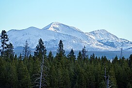
Trilobite Point
Tools
Actions
General
Print/export
In other projects
Appearance
From Wikipedia, the free encyclopedia
Mountain in Montana, United States
| Trilobite Point | |
|---|---|
 Trilobite Point (right of Mount Holmes) from Madison River | |
| Highest point | |
| Elevation | 10,010 ft (3,050 m) |
| Coordinates | 44°49′01″N 110°50′38″W / 44.81694°N 110.84389°W / 44.81694; -110.84389 (Trilobite Point)[1] |
| Geography | |
| Location | Yellowstone National Park, Park County, Montana |
| Parent range | Gallatin Range |
Trilobite Point is a mountain peak in the southern section of the Gallatin Range in Yellowstone National Park. It has an elevation of 10,010 feet (3,050 m).
See also
[edit]Notes
[edit]Yellowstone National Park - Mammoth Hot Springs | ||
|---|---|---|
Historic structures and other attractions in the Mammoth Hot Springs area | ||
| Structures and history | ||
| Geography and geology | ||
| ||


