
Tvarožná (Brno-Country District)
Tvarožná | |
|---|---|
 View from the west | |
 Flag  Coat of arms | |
 Tvarožná Location in the Czech Republic | |
| Coordinates: 49°11′30″N 16°46′17″E / 49.19167°N 16.77139°E | |
| Country | |
| Region | South Moravian |
| District | Brno-Country |
| First mentioned | 1288 |
| Area | |
| • Total | 8.81 km2 (3.40 sq mi) |
| Elevation | 257 m (843 ft) |
| Population (2023-01-01)[1] | |
| • Total | 1,339 |
| • Density | 150/km2 (390/sq mi) |
| Time zone | UTC+1 (CET) |
| • Summer (DST) | UTC+2 (CEST) |
| Postal code | 664 05 |
| Website | www |
Tvarožná (German: Bosenitz) is a municipality and village in Brno-Country District in the South Moravian Region of the Czech Republic. It has about 1,300 inhabitants.
Geography[edit]
Tvarožná is located about 10 kilometres (6 mi) east of Brno. It lies on the border between the Drahany Highlands and Dyje–Svratka Valley. The highest point is at 400 m (1,300 ft) above sea level. The brook of Tvaroženský potok flows through the municipality. There is one fishpond in the municipal territory.
History[edit]
The first written mention of Tvarožnice (written as Twarszonicz) is from 1288. The village was originally formed from two separate settlements, Tvarožnice and Važanice, which merged into one in the 15th century and were renamed Tvarožná.[2]
The municipality is famous for the Battle of Austerlitz in 1805. Santon hill in the municipality was a strategic location for Napoleon's army, being occupied by the French general Claparèd and his 17th regiment.[3]
Demographics[edit]
|
|
| ||||||||||||||||||||||||||||||||||||||||||||||||||||||
| Source: Censuses[4][5] | ||||||||||||||||||||||||||||||||||||||||||||||||||||||||
Transport[edit]
The D1 motorway from Brno to Ostrava passes through the southern part of the municipal territory.
Sights[edit]
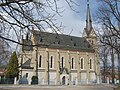
The Church of Saint Nicholas is the landmark of the village. It was built in the neo-Gothic style in 1880–1881 and replaced an old structure from the early 14th century.[6]
The Santon hill with an elevation of 296 metres (971 ft) is a view-point protected as a nature monument. On the top of the hill is the Chapel of Saint Mary Major from 1832.[7]
In Tvarožná is a replica of the French canon Gribeauval to commemorate the Battle of Austerlitz. It was originally placed on the Santon hill and later moved to the centre of the village.[8]
Gallery[edit]
-
 Church of Saint Nicholas
 -
 Chapel on Santon hill
 -
 Santon hill
 -
 View of Tvarožná from Santon
 -
 Panorama
 -
 Common in Tvarožná


References[edit]
- ^ "Population of Municipalities – 1 January 2023". Czech Statistical Office. 2023-05-23.
- ^ "Nejstarší dějiny obce" (in Czech). Obec Tvarožná. Retrieved 2023-11-01.
- ^ "Bitva u Slavkova" (in Czech). Československá napoleonská společnost. Retrieved 2021-11-13.
- ^ "Historický lexikon obcí České republiky 1869–2011 – Okres Brno-venkov" (in Czech). Czech Statistical Office. 2015-12-21. pp. 13–14.
- ^ "Population Census 2021: Population by sex". Public Database. Czech Statistical Office. 2021-03-27.
- ^ "Kostel sv. Mikuláše" (in Czech). Obec Tvarožná. Retrieved 2021-11-13.
- ^ "Významné památky a krajinné prvky" (in Czech). Obec Tvarožná. Retrieved 2021-11-13.
- ^ "Kopie francouzského osmiliberního kanonu" (in Czech). Obec Tvarožná. Retrieved 2021-11-13.
External links[edit]
- Official website
- Project Austerlitz – information about the battle
| International | |
|---|---|
| National | |